TROPICAL STORM BARRY AL02
………BARRY GETS A LITTLE STRONGER AS IT NEARS THE LOUISIANA COAST…
…DANGEROUS STORM SURGE, HEAVY RAINS, AND WIND CONDITIONS
EXPECTED ACROSS THE NORTH-CENTRAL GULF COAST…..Barry is expected to be a hurricane when the
center reaches the Louisiana coast during the next several hours..NHC
A Hurricane Warning is in effect for…
* Intracoastal City to Grand Isle
A Tropical Storm Warning is in effect for…
* Mouth of the Pearl River to Grand Isle
* Lake Pontchartrain and Lake Maurepas including metropolitan New
Orleans
* Intracoastal City to Cameron
A Storm Surge Warning is in effect for…
* Intracoastal City to Biloxi
* Lake Pontchartrain
A Storm Surge Watch is in effect for…
* Biloxi to the Mississippi/Alabama border
A Hurricane Watch is in effect for…
* Mouth of the Mississippi River to Grand Isle
* Intracoastal City to Cameron
A Tropical Storm Watch is in effect for…
* East of the Mouth of the Pearl River to the Mississippi/Alabama
border
SEE UPDATES IN COMMENTS AT BOTTOM OF PAGE
NATIONAL HURRICANE CENTER FL
Storm Surge
Watch/Warning (link)

D: Tropical Depression – wind speed less than 39 MPH
S: Tropical Storm – wind speed between 39 MPH and 73 MPH
H: Hurricane – wind speed between 74 MPH and 110 MPH
M: Major Hurricane – wind speed greater than 110 MPH


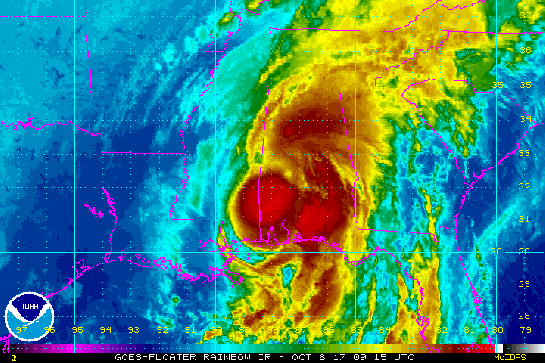
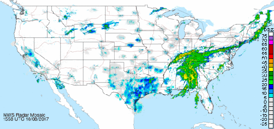
NWS radar Image from New Orleans/Baton Rouge, LA


000
WTNT32 KNHC 131152
TCPAT2
BULLETIN
Tropical Storm Barry Intermediate Advisory Number 12A
NWS National Hurricane Center Miami FL AL022019
700 AM CDT Sat Jul 13 2019
…BARRY GETS A LITTLE STRONGER AS IT NEARS THE LOUISIANA COAST…
…DANGEROUS STORM SURGE, HEAVY RAINS, AND WIND CONDITIONS
EXPECTED ACROSS THE NORTH-CENTRAL GULF COAST…
SUMMARY OF 700 AM CDT…1200 UTC…INFORMATION
———————————————-
LOCATION…29.3N 91.9W
ABOUT 50 MI…80 KM WSW OF MORGAN CITY LOUISIANA
ABOUT 60 MI…95 KM S OF LAFAYETTE LOUISIANA
MAXIMUM SUSTAINED WINDS…70 MPH…115 KM/H
PRESENT MOVEMENT…NW OR 305 DEGREES AT 5 MPH…7 KM/H
MINIMUM CENTRAL PRESSURE…991 MB…29.26 INCHES
WATCHES AND WARNINGS
——————–
CHANGES WITH THIS ADVISORY…
None.
SUMMARY OF WATCHES AND WARNINGS IN EFFECT…
A Hurricane Warning is in effect for…
* Intracoastal City to Grand Isle
A Tropical Storm Warning is in effect for…
* Mouth of the Pearl River to Grand Isle
* Lake Pontchartrain and Lake Maurepas including metropolitan New
Orleans
* Intracoastal City to Cameron
A Storm Surge Warning is in effect for…
* Intracoastal City to Biloxi
* Lake Pontchartrain
A Storm Surge Watch is in effect for…
* Biloxi to the Mississippi/Alabama border
A Hurricane Watch is in effect for…
* Mouth of the Mississippi River to Grand Isle
* Intracoastal City to Cameron
A Tropical Storm Watch is in effect for…
* East of the Mouth of the Pearl River to the Mississippi/Alabama
border
A Hurricane Warning means that hurricane conditions are expected
somewhere within the warning area. A warning is typically issued
36 hours before the anticipated first occurrence of
tropical-storm-force winds, conditions that make outside
preparations difficult or dangerous. Preparations to protect life
and property should be rushed to completion.
A Tropical Storm Warning means that tropical storm conditions are
expected somewhere within the warning area within 36 hours.
A Storm Surge Warning means there is a danger of life-threatening
inundation from rising water moving inland from the coastline
during the next 36 hours in the indicated locations. For a
depiction of areas at risk please see the National Weather
Service Storm Surge Watch/Warning Graphic available at
hurricanes.gov. This is a life-threatening situation. Persons
located within these areas should take all necessary actions to
protect life and property from rising water and the potential for
other dangerous conditions. Promptly follow evacuation and other
instructions from local officials.
A Storm Surge Watch means there is a possibility of life-
threatening inundation from rising water moving inland from the
coastline in the indicated locations during the next 48 hours.
A Hurricane Watch means that hurricane conditions are possible
within the watch area. A watch is typically issued 48 hours
before the anticipated first occurrence of tropical-storm-force
winds conditions that make outside preparations difficult or
dangerous.
A Tropical Storm Watch means that tropical storm conditions are
possible within the watch area generally within 48 hours.
For storm information specific to your area, including possible
inland watches and warnings, please monitor products issued by your
local National Weather Service forecast office.
DISCUSSION AND OUTLOOK
———————-
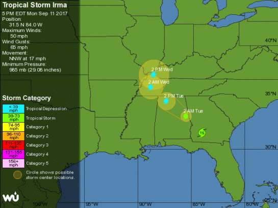
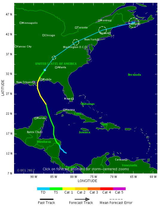
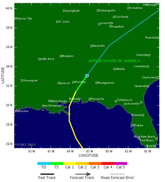
At 700 AM CDT (1200 UTC), the center of Tropical Storm Barry was
located near latitude 29.3 North, longitude 91.9 West. Barry is
moving toward the northwest near 5 mph (7 km/h), and a turn
toward the north is expected tonight or Sunday. On the forecast
track, the center of Barry will make landfall along the
south-central Louisiana coast during the next several hours.
After landfall, Barry is expected to move generally northward
through the Mississippi Valley through Sunday night.
Maximum sustained winds have increased to near near 70 mph
(115 km/h) with higher gusts. Additional strengthening is forecast
before landfall, and Barry is expected to be a hurricane when the
center reaches the Louisiana coast during the next several hours.
Steady weakening is expected after Barry moves inland.
Tropical-storm-force winds extend outward up to 175 miles (280 km)
from the center. The National Ocean Service station at Eugene
Island, Louisiana recently reported sustained winds of 71 mph and a
wind gust of 85 mph.
The estimated minimum central pressure based on surface observations
is 991 mb (29.26 inches). An Air Force Reserve Hurricane Hunter
aircraft is currently enroute to investigate Barry.
HAZARDS AFFECTING LAND
———————-
Key Messages for Barry can be found in the Tropical Cyclone
Discussion under AWIPS header MIATCDAT2 and WMO header WTNT42 KNHC.
STORM SURGE: The combination of a dangerous storm surge and the
tide will cause normally dry areas near the coast to be flooded by
rising waters moving inland from the shoreline. The water could
reach the following heights above ground somewhere in the indicated
areas if the peak surge occurs at the time of high tide…
Intracoastal City to Shell Beach…3 to 6 ft
Shell Beach to Biloxi MS…3 to 5 ft
Lake Pontchartrain…3 to 5 ft
Biloxi MS to the Mississippi/Alabama border…2 to 4 ft
Lake Maurepas…1 to 3 ft
Surge-related flooding depends on the relative timing of the surge
and the tidal cycle, and can vary greatly over short distances. For
information specific to your area, please see products issued by
your local National Weather Service forecast office.
RAINFALL: Barry is expected to produce total rain accumulations of
10 to 20 inches over south-central and southeast Louisiana and
southwest Mississippi, with isolated maximum amounts of 25 inches.
These rains are expected to lead to dangerous, life threatening
flooding over portions of the central Gulf Coast into the Lower
Mississippi Valley beginning as early as later this morning. Across
the remainder of the Lower Mississippi Valley, total rain
accumulations of 4 to 8 inches are expected, with isolated maximum
amounts of 12 inches. By early next week, Barry is expected to
produce rainfall accumulations of 4 to 8 inches across western
portions of the Tennessee Valley.
WIND: Hurricane conditions are expected in the Hurricane Warning
area later this morning, with tropical storm conditions currently
spreading across the area. Hurricane conditions are possible within
the Hurricane Watch area later this morning. Tropical storm
conditions are occurring across the Tropical Storm Warning area in
southeastern Louisiana at this time. Tropical storm conditions are
possible in the Tropical Storm Watch area later today. Wind gusts
to tropical-storm force in squalls are possible along portions of
the coasts of Alabama and the western Florida Panhandle through
tonight.
TORNADOES: A few tornadoes are possible through tonight across
the southeast Louisiana, southern Mississippi, and southern Alabama.
NEXT ADVISORY
————-
Next complete advisory at 1000 AM CDT.
$$
Forecaster Beven
Local Products
| Issuing WFO Homepage | Local Impacts | Local Statement |
|---|---|---|
| New Orleans / Baton Rouge, LA | Threats and Impacts | 457 AM CDT Sat Jul 13 |
| Lake Charles, LA | Threats and Impacts | 503 AM CDT Sat Jul 13 |


TROPICAL STORM RISK
University College London, UK
N Atlantic: Storm Alert issued at 13 Jul, 2019 9:00 GMT
Tropical Storm BARRY is currently located near 29.1 N 91.8 W with maximum 1-min sustained winds of 55kts (63 mph). BARRY is forecast to affect land to the following likelihood(s) at the given lead time(s):
Red Alert Country(s) or Province(s)
the United States
probability for CAT 1 or above is 35% within 9 hours
probability for TS is 100% currently
Yellow Alert City(s) and Town(s)
Baton Rouge (30.5 N, 91.2 W)
probability for TS is 85% within 9 hours
New Orleans (30.0 N, 90.1 W)
probability for TS is 65% within 9 hours
Note that
Red Alert (Severe) is CAT 1 or above to between 31% and 100% probability.
Yellow Alert (Elevated) is CAT 1 or above to between 10% and 30% probability, or TS to above 50% probability.
CAT 1 means Hurricane strength winds of at least 74 mph, 119 km/h or 64 knots 1-min sustained.
TS means Tropical Storm strength winds of at least 39 mph, 63 km/h or 34 knots 1-min sustained.
For graphical forecast information and further details please visit http://www.tropicalstormrisk.com/


Current probability of tropical storm winds

Current probability of Cat 1 or above winds

Other

(Image: @RoshinRowjee)
MARITIME/SHIPPING
Offshore Waters Forecast (Gulf of Mexico)
000
FZNT24 KNHC 130845
OFFNT4
Offshore Waters Forecast for the Gulf of Mexico
NWS National Hurricane Center Miami, FL
445 AM EDT Sat Jul 13 2019
Offshore Waters Forecast for the Gulf of Mexico
Seas given as significant wave height, which is the average
height of the highest 1/3 of the waves. Individual waves may be
more than twice the significant wave height.
GMZ001-132045-
Synopsis for the Gulf of Mexico
445 AM EDT Sat Jul 13 2019
.SYNOPSIS…Tropical Storm Barry near 29.1N 91.8W 993 mb at 5 AM
EDT moving WNW at 4 kt. Maximum sustained winds 55 kt gusts 65 kt.
Barry is forecast to reach hurricane strength as it nears the
coast just prior to landfall. Barry will move inland to 29.8N
92.1W this afternoon, to 30.9N 92.6W Sun morning, weaken to a
tropical depression near 32.3N 92.9W Sun afternoon, to 33.8N 93.0W
Mon morning, and 35.0N 93.0W Tue morning. Barry will become a
remnant low as it moves to 36.5N 92.5W early Wed, and dissipate by
Thu. Winds and seas will diminish and subside across the basin Sun
into early next week as high pres ridging builds westward across
the basin.
$$
GMZ011-132045-
NW Gulf including Stetson Bank-
445 AM EDT Sat Jul 13 2019
.TODAY…W winds 15 to 20 kt. Seas 4 to 6 ft.
Numerous showers and scattered thunderstorms.
.TONIGHT…S to SW winds 15 to 20 kt. Seas 4 to 6 ft.
Scattered showers and isolated thunderstorms.
.SUN…S to SW winds 15 to 20 kt. Seas 4 to 6 ft.
Scattered showers and isolated thunderstorms.
.SUN NIGHT…S winds 10 to 15 kt. Seas 3 to 5 ft.
.MON…S winds 10 to 15 kt. Seas 3 to 5 ft.
.MON NIGHT…SE to S winds 10 to 15 kt. Seas 2 to 4 ft.
.TUE…SE to S winds 10 to 15 kt. Seas 2 to 4 ft.
.TUE NIGHT…SE to S winds 10 to 15 kt. Seas 2 to 4 ft.
.WED…SE to S winds 10 to 15 kt. Seas 2 to 4 ft.
.WED NIGHT…SE to S winds 10 to 15 kt. Seas 2 to 4 ft.
$$
GMZ013-132045-
N Central Gulf including Flower Garden Banks Marine Sanctuary-
445 AM EDT Sat Jul 13 2019
…TROPICAL STORM WARNING…
.TODAY…TROPICAL STORM CONDITIONS. S to SW winds 30 to 40 kt.
Seas 9 to 14 ft. Numerous showers and scattered thunderstorms.
.TONIGHT…TROPICAL STORM CONDITIONS POSSIBLE. S winds 25 to 30
kt. Seas 7 to 11 ft. Scattered showers and isolated thunderstorms.
.SUN…S winds 20 to 25 kt. Seas 6 to 8 ft.
Scattered showers and isolated thunderstorms.
.SUN NIGHT…S winds 20 to 25 kt. Seas 4 to 6 ft.
.MON…SE to S winds 15 to 20 kt. Seas 3 to 5 ft.
.MON NIGHT…SE to S winds 10 to 15 kt. Seas 2 to 4 ft.
.TUE…SE winds 10 to 15 kt. Seas 2 to 4 ft.
.TUE NIGHT…SE winds 10 to 15 kt. Seas 3 ft or less.
.WED…SE winds 10 to 15 kt. Seas 3 ft or less.
$$
GMZ015-132045-
NE Gulf N of 25N E of 87W-
445 AM EDT Sat Jul 13 2019
.TODAY…SE winds 15 to 20 kt S of 27N, and SE to S 20 to 25 kt
elsewhere. Seas 7 to 11 ft in W swell. Isolated thunderstorms.
.TONIGHT…SE winds 15 to 20 kt. Seas 6 to 8 ft in W swell.
.SUN…SE winds 15 to 20 kt. Seas 5 to 7 ft.
.SUN NIGHT…SE winds 10 to 15 kt. Seas 3 to 5 ft.
.MON…SE winds 10 to 15 kt. Seas 2 to 4 ft.
.MON NIGHT…E to SE winds 10 kt. Seas 3 ft or less.
.TUE…E to SE winds 10 to 15 kt. Seas 3 ft or less.
.TUE NIGHT…E winds 10 kt. Seas 3 ft or less.
.WED…E to SE winds 10 kt. Seas 3 ft or less.
.WED NIGHT…SE winds 10 kt. Seas 3 ft or less.
$$
GMZ017-132045-
W Central Gulf from 22N to 26N W of 94W-
445 AM EDT Sat Jul 13 2019
.TODAY…S to SW winds 15 to 20 kt, becoming S 10 to 15 kt in
the afternoon. Seas 3 to 5 ft.
Scattered showers and isolated thunderstorms.
.TONIGHT…SE to S winds 10 to 15 kt. Seas 3 to 5 ft.
.SUN…SE to S winds 10 to 15 kt. Seas 3 to 5 ft.
.SUN NIGHT…SE to S winds 10 to 15 kt. Seas 2 to 4 ft.
.MON…SE to S winds 10 to 15 kt. Seas 2 to 4 ft.
.MON NIGHT…SE winds 10 to 15 kt. Seas 2 to 4 ft.
.TUE…SE winds 10 to 15 kt. Seas 2 to 4 ft.
.TUE NIGHT…SE winds 10 to 15 kt. Seas 2 to 4 ft.
.WED…SE winds 10 to 15 kt. Seas 2 to 4 ft.
.WED NIGHT…SE winds 10 to 15 kt. Seas 2 to 4 ft.
$$
GMZ019-132045-
Central Gulf from 22N to 26N between 87W and 94W-
445 AM EDT Sat Jul 13 2019
.TODAY…SE to S winds 20 to 25 kt. Seas 6 to 9 ft in W to NW
swell. Scattered showers and isolated thunderstorms.
.TONIGHT…SE winds 15 to 20 kt. Seas 5 to 7 ft.
.SUN…SE to S winds 15 to 20 kt. Seas 5 to 7 ft.
.SUN NIGHT…E to SE winds 15 to 20 kt. Seas 3 to 5 ft.
.MON…SE winds 15 to 20 kt. Seas 2 to 4 ft.
.MON NIGHT…E to SE winds 15 to 20 kt. Seas 2 to 4 ft.
.TUE…E to SE winds 15 to 20 kt. Seas 2 to 4 ft.
.TUE NIGHT…E to SE winds 15 to 20 kt. Seas 2 to 4 ft.
.WED…E to SE winds 15 to 20 kt. Seas 2 to 4 ft.
.WED NIGHT…E to SE winds 10 to 15 kt. Seas 2 to 4 ft.
$$
GMZ021-132045-
E Gulf from 22N to 25N E of 87W including Straits of Florida-
445 AM EDT Sat Jul 13 2019
.TODAY…SE winds 10 to 15 kt. Seas 4 to 6 ft.
Isolated thunderstorms.
.TONIGHT…E to SE winds 10 to 15 kt. Seas 3 to 5 ft.
.SUN…E to SE winds 10 to 15 kt. Seas 3 to 5 ft.
.SUN NIGHT…E winds 10 to 15 kt. Seas 3 to 5 ft.
.MON…E to SE winds 10 to 15 kt. Seas 2 to 4 ft.
.MON NIGHT…E winds 10 to 15 kt. Seas 3 ft or less.
.TUE…E to SE winds 10 to 15 kt. Seas 3 ft or less.
.TUE NIGHT…E winds 10 to 15 kt. Seas 3 ft or less.
.WED…E to SE winds 10 to 15 kt. Seas 3 ft or less.
.WED NIGHT…E winds 10 kt. Seas 3 ft or less.
$$
GMZ023-132045-
SW Gulf S of 22N W of 94W-
445 AM EDT Sat Jul 13 2019
.TODAY…SE winds 10 kt. Seas 3 ft or less.
.TONIGHT…E to SE winds 10 to 15 kt. Seas 3 ft or less.
.SUN…E to SE winds 10 to 15 kt. Seas 2 to 4 ft.
.SUN NIGHT…E winds 10 to 15 kt. Seas 2 to 4 ft.
.MON…E to SE winds 10 to 15 kt. Seas 2 to 4 ft.
.MON NIGHT…E winds 10 to 15 kt. Seas 3 ft or less.
.TUE…E to SE winds 10 to 15 kt. Seas 3 ft or less.
.TUE NIGHT…E winds 10 to 15 kt. Seas 3 ft or less.
.WED…E winds 10 to 15 kt. Seas 2 to 4 ft.
.WED NIGHT…E winds 10 to 15 kt. Seas 3 ft or less.
$$
GMZ025-132045-
E Bay of Campeche including Campeche Bank-
445 AM EDT Sat Jul 13 2019
.TODAY…E to SE winds 15 to 20 kt. Seas 3 to 5 ft.
.TONIGHT…E winds 15 to 20 kt. Seas 3 to 5 ft.
.SUN…E to SE winds 15 to 20 kt. Seas 3 to 5 ft.
.SUN NIGHT…E winds 15 to 20 kt. Seas 3 to 5 ft.
.MON…E to SE winds 15 to 20 kt. Seas 2 to 4 ft.
.MON NIGHT…NE to E winds 15 to 20 kt. Seas 2 to 4 ft.
.TUE…E to SE winds 10 to 15 kt. Seas 3 ft or less.
.TUE NIGHT…NE to E winds 15 to 20 kt. Seas 2 to 4 ft.
.WED…E to SE winds 15 to 20 kt. Seas 2 to 4 ft.
.WED NIGHT…NE to E winds 15 to 20 kt. Seas 2 to 4 ft.
$$
Forecaster Lewitsky
High Seas Forecast (Tropical Atlantic)
000
FZNT02 KNHC 130849
HSFAT2
HIGH SEAS FORECAST
NWS NATIONAL HURRICANE CENTER MIAMI FL
1030 UTC SAT JUL 13 2019
SUPERSEDED BY NEXT ISSUANCE IN 6 HOURS
SEAS GIVEN AS SIGNIFICANT WAVE HEIGHT…WHICH IS THE AVERAGE
HEIGHT OF THE HIGHEST 1/3 OF THE WAVES. INDIVIDUAL WAVES MAY BE
MORE THAN TWICE THE SIGNIFICANT WAVE HEIGHT.
SECURITE
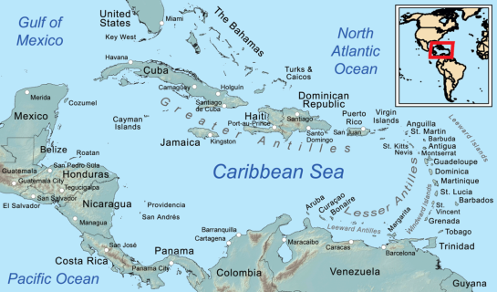
ATLANTIC FROM 07N TO 31N W OF 35W INCLUDING CARIBBEAN SEA AND
GULF OF MEXICO
SYNOPSIS VALID 0600 UTC SAT JUL 13.
24 HOUR FORECAST VALID 0600 UTC SUN JUL 14.
48 HOUR FORECAST VALID 0600 UTC MON JUL 15.
.WARNINGS.
…GULF OF MEXICO HURRICANE WARNING…
.TROPICAL STORM BARRY NEAR 29.1N 91.8W 993 MB AT 0900 UTC JUL 13
MOVING WNW OR 300 DEG AT 4 KT. MAXIMUM SUSTAINED WINDS 55 KT
GUSTS 65 KT. TROPICAL STORM FORCE WINDS WITHIN 90 NM NE
QUADRANT…150 NM SE QUADRANT…130 NM SW QUADRANT…AND 70 NM
NW QUADRANT. SEAS 12 FT OR GREATER WITHIN 300 NM NE QUADRANT…
180 NM SE QUADRANT…60 NM SW QUADRANT…AND 30 NM NW QUADRANT
WITH SEAS TO 23 FT. ELSEWHERE WITHIN 22N89W TO 30N93W TO 27N89W
TO 31N88W TO 27N84W TO 22N89W WINDS 20 TO 33 KT. SEAS 8 TO 12 FT.
.06 HOUR FORECAST HURRICANE BARRY 29.4N 91.9W. MAXIMUM SUSTAINED
WINDS 65 KT GUSTS 80 KT. TROPICAL STORM FORCE WINDS WITHIN 90 NM
NE QUADRANT…150 NM SE QUADRANT…130 NM SW QUADRANT…AND 70
NM NW QUADRANT. SEAS 12 FT OR GREATER WITHIN 300 NM NE
QUADRANT…270 NM SE QUADRANT…90 NM SW QUADRANT AND 0 NM NW
QUADRANT WITH SEAS TO 25 FT. ELSEWHERE WITHIN 24N90W TO 26N94W TO
30N93W TO 28N89W TO 29N84W TO 24N90W WINDS 20 TO 33 KT. SEAS 8
TO 12 FT.
.24 HOUR FORECAST TROPICAL STORM BARRY INLAND NEAR 30.9N 92.6W.
MAXIMUM SUSTAINED WINDS 45 KT GUSTS 55 KT. TROPICAL STORM FORCE
WINDS WITHIN 50 NM NE QUADRANT…150 NM SE QUADRANT…105 NM SW
QUADRANT…AND 0 NM NW QUADRANT. SEAS 12 FT OR GREATER OVER
FORECAST WATERS WITHIN 150 NM SE QUADRANT WITH SEAS TO 12 FT.
ELSEWHERE WITHIN 27N90W TO 27N94W TO 29N94W TO 30N90W TO 29N86W
TO 27N90W WINDS 20 TO 33 KT. SEAS 8 TO 12 FT.
.48 HOUR FORECAST TROPICAL DEPRESSION BARRY INLAND NEAR 33.8N
93.0W. MAXIMUM SUSTAINED WINDS 25 KT GUSTS 35 KT. OVER FORECAST
WATERS WINDS 20 KT OR LESS. SEAS LESS THAN 8 FT.
.72 HOUR FORECAST TROPICAL DEPRESSION BARRY NEAR 35.0N 93.0W.
MAXIMUM SUSTAINED WINDS 20 KT GUSTS 30 KT.
EXTENDED OUTLOOK…USE FOR GUIDANCE ONLY…ERRORS MAY BE LARGE.
.96 HOUR FORECAST POST-TROPICAL REMNANT LOW BARRY NEAR 36.5N
92.5W. MAXIMUM SUSTAINED WINDS 20 KT GUSTS 30 KT.
.120 HOUR FORECAST…DISSIPATED.
FORECAST WINDS IN AND NEAR ACTIVE TROPICAL CYCLONES SHOULD BE
USED WITH CAUTION DUE TO UNCERTAINTY IN FORECAST TRACK…SIZE
AND INTENSITY.
.SYNOPSIS AND FORECAST.
.ATLC WITHIN 12N40W TO 12N41W TO 13N40W TO 12N40W NE TO E WINDS
20 TO 25 KT. SEAS TO 8 FT.
.24 HOUR FORECAST WITHIN 13N46W TO 12N48W TO 13N48W TO 13N47W TO
13N46W NE TO E WINDS 20 TO 25 KT. SEAS TO 8 FT.
.48 HOUR FORECAST WITHIN 14N54W TO 12N55W TO 14N60W TO 16N59W TO
16N56W TO 14N54W NE TO E WINDS 20 TO 25 KT. SEAS 8 TO 9 FT.
.CARIBBEAN WITHIN 11N71W TO 11N75W TO 13N77W TO 14N75W TO 14N72W
TO 11N71W NE TO E WINDS 20 TO 30 KT. SEAS 8 TO 11 FT.
.24 HOUR FORECAST WITHIN 11N74W TO 12N78W TO 17N73W TO 18N72W TO
15N72W TO 11N74W NE TO E WINDS 20 TO 30 KT. SEAS 8 TO 11 FT.
.48 HOUR FORECAST WITHIN 11N71W TO 11N75W TO 14N77W TO 17N73W TO
15N70W TO 11N71W E WINDS 20 TO 30 KT. SEAS 8 TO 12 FT.
.CARIBBEAN WITHIN 16N86W TO 16N87W TO 16N88W TO 18N88W TO 18N86W
TO 16N86W E TO SE WINDS 20 TO 25 KT. SEAS TO 8 FT.
.06 HOUR FORECAST WINDS 20 KT OR LESS. SEAS LESS THAN 8 FT.
.REMAINDER OF AREA WINDS 20 KT OR LESS. SEAS LESS THAN 8 FT.
$$
.FORECASTER LEWITSKY. NATIONAL HURRICANE CENTER.
===========================================================================================================
Do not use any information on this site for life or death decisions. All information is intended as supplementary to official sources. Kindly refer to your country’s official weather agency/government website for local warnings, advisories and bulletins.


 CANADA