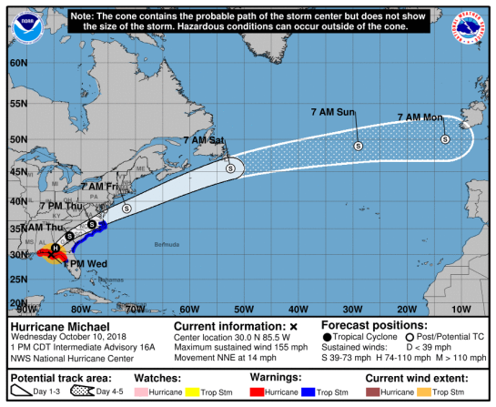
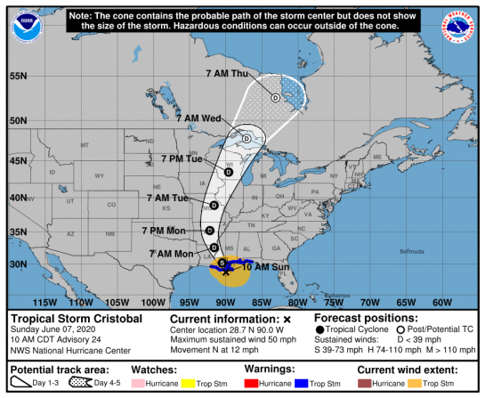
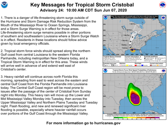
MAJOR HURRICANE MICHAEL
Michael is an extremely dangerous category 4 hurricane on the Saffir-Simpson Hurricane Wind Scale.
…MICHAEL INTENSIFIES AS IT MAKES LANDFALL NEAR MEXICO BEACH FLORIDA…
…LIFE-THREATENING STORM SURGE…HURRICANE FORCE WINDS…AND HEAVY
RAINFALL OCCURING OVER THE FLORIDA PANHANDLE… NHC
A Storm Surge Warning is in effect for…
* Okaloosa/Walton County Line Florida to Anclote River Florida
A Storm Surge Watch is in effect for…
* Anclote River Florida to Anna Maria Island Florida, including
Tampa Bay
* Ocracoke Inlet North Carolina to Duck North Carolina
A Hurricane Warning is in effect for…
* Alabama/Florida border to Suwannee River Florida
A Tropical Storm Warning is in effect for…
* Suwanee River Florida to Chassahowitzka Florida
* North of Fernandina Beach Florida to Duck North Carolina
* Pamlico and Albemarle Sounds
National Hurricane Center


TORNADOES (see below)
000
WTNT34 KNHC 101737
TCPAT4
BULLETIN
Hurricane Michael Intermediate Advisory Number 16A
NWS National Hurricane Center Miami FL AL142018
100 PM CDT Wed Oct 10 2018
…MICHAEL INTENSIFIES AS IT MAKES LANDFALL NEAR MEXICO BEACH
FLORIDA…
…LIFE-THREATENING STORM SURGE…HURRICANE FORCE WINDS…AND HEAVY
RAINFALL OCCURING OVER THE FLORIDA PANHANDLE…
SUMMARY OF 100 PM CDT…1800 UTC…INFORMATION
———————————————-
LOCATION…30.0N 85.5W
ABOUT 5 MI…10 KM NW OF MEXICO BEACH FLORIDA
ABOUT 20 MI…30 KM SE OF PANAMA CITY FLORIDA
MAXIMUM SUSTAINED WINDS…155 MPH…250 KM/H
PRESENT MOVEMENT…NNE OR 20 DEGREES AT 14 MPH…22 KM/H
MINIMUM CENTRAL PRESSURE…919 MB…27.41 INCHES
WATCHES AND WARNINGS
——————–
CHANGES WITH THIS ADVISORY:
The Tropical Storm Warning has been discontinued west of the
Alabama/Florida border.
The Tropical Storm Watch along the west coast of Florida has been
discontinued south of Chassahowitzka.
SUMMARY OF WATCHES AND WARNINGS IN EFFECT:
A Storm Surge Warning is in effect for…
* Okaloosa/Walton County Line Florida to Anclote River Florida
A Storm Surge Watch is in effect for…
* Anclote River Florida to Anna Maria Island Florida, including
Tampa Bay
* Ocracoke Inlet North Carolina to Duck North Carolina
A Hurricane Warning is in effect for…
* Alabama/Florida border to Suwannee River Florida
A Tropical Storm Warning is in effect for…
* Suwanee River Florida to Chassahowitzka Florida
* North of Fernandina Beach Florida to Duck North Carolina
* Pamlico and Albemarle Sounds
A Storm Surge Warning means there is a danger of life-threatening
inundation, from rising water moving inland from the coastline. For
a depiction of areas at risk, please see the National Weather
Service Storm Surge Watch/Warning Graphic, available at
hurricanes.gov.
A Hurricane Warning means that hurricane conditions are expected
somewhere within the warning area.
A Tropical Storm Warning means that tropical storm conditions are
expected somewhere within the warning area.
A Storm Surge Watch means there is a possibility of life-
threatening inundation, from rising water moving inland from the
coastline.
Interests elsewhere across the southeastern United States should
monitor the progress of Michael.
For storm information specific to your area, including possible
inland watches and warnings, please monitor products issued by your
local National Weather Service forecast office.
DISCUSSION AND OUTLOOK
———————-
Satellite, aircraft, and radar data indicate that the eye of
Michael is making landfall just northwest of Mexico Beach, Florida.
At 100 PM CDT (1800 UTC), the eye of Hurricane Michael was located
near latitude 30.0 North, longitude 85.5 West. Michael is moving
toward the north-northeast near 14 mph (22 km/h). A turn toward the
northeast is expected this afternoon or tonight. A motion toward
the northeast at a faster forward speed is forecast on Thursday
through Friday night. On the forecast track, the core of Michael
will move inland across the Florida Panhandle this afternoon, and
across southeastern Alabama and southwestern Georgia tonight.
Michael will move northeastward across the southeastern United
States through Thursday night, and then move off the Mid-Atlantic
coast away from the United States on Friday.
Recent data from NOAA and Air Force Reserve Hurricane Hunter
aircraft indicate that maximum sustained winds have increased to
near 155 mph (250 km/h) with higher gusts. Michael is an extremely
dangerous category 4 hurricane on the Saffir-Simpson Hurricane Wind
Scale. Michael should weaken as it crosses the southeastern United
States. Michael is forecast to become a post-tropical cyclone on
Friday, and strengthening is forecast as the system moves over the
western Atlantic.
Hurricane-force winds extend outward up to 45 miles (75 km) from
the center and tropical-storm-force winds extend outward up to 175
miles (280 km). A wind gust of 130 mph (210 mph) was recently
reported at a University of Florida/Weatherflow observing site near
Tyndall Air Force Base before the instrument failed. A wind gust to
129 mph (207 km/h) was reported at the Panama City Airport.
The latest minimum central pressure based on data from an Air Force
Reserve reconnaissance aircraft is 919 mb (27.41 inches).
A minimum pressure of 920 mb was recently reported by a University
of Florida/Weatherflow observing site near Tyndall Air Force Base.
HAZARDS AFFECTING LAND
———————-
STORM SURGE: The combination of a dangerous storm surge and the
tide will cause normally dry areas near the coast to be flooded by
rising waters moving inland from the shoreline. The water has the
potential to reach the following heights above ground if peak surge
occurs at the time of high tide…
Tyndall Air Force Base FL to Aucilla River FL…9-14 ft
Okaloosa/Walton County Line FL to Tyndall Air Force Base FL…6-9 ft
Aucilla River FL to Cedar Key FL…6-9 ft
Cedar Key FL to Chassahowitzka FL…4-6 ft
Chassahowitzka to Anna Maria Island FL including Tampa Bay…2-4 ft
Sound side of the North Carolina Outer Banks from Ocracoke Inlet to
Duck…2-4 ft
Water levels continue to rise quickly along the coast of the Florida
Panhandle. A National Ocean Service water level station at
Apalachicola recently reported over 6.5 feet of inundation above
ground level.
WIND: Tropical storm and hurricane conditions will continue
to spread inland across portions of the Florida Panhandle,
southeastern Alabama and southwestern Georgia this afternoon and
tonight.
With the landfall of Michael’s eye occurring, everyone in the
landfall area is reminded not to venture out into the relative calm
of the eye, as hazardous winds will increase very quickly as the eye
passes!
Tropical storm conditions are expected to spread northward within
the warning area along the southeast U.S. coast beginning tonight
through Friday.
RAINFALL: Michael is expected to produce the following rainfall
amounts through Friday…
Florida Panhandle and Big Bend, southeast Alabama, and portions of
southwest and central Georgia…4 to 8 inches, with isolated maximum
amounts of 12 inches. This rainfall could lead to life-threatening
flash floods.
The remainder of Georgia, the Carolinas, and southern Virginia…3
to 6 inches, with isolated maximum amounts of 8 inches. This
rainfall could lead to life-threatening flash floods.
Florida Peninsula, eastern Mid Atlantic, southern New England
coast…1-3 inches.
SURF: Swells generated by Michael will affect the coasts of the
eastern, northern, and western Gulf of Mexico during the next day
or so. These swells are likely to cause life-threatening surf
and rip current conditions. Please consult products from your local
weather office.
TORNADOES: Tornadoes are possible across parts of the Florida
Panhandle and the northern Florida Peninsula through this afternoon.
This risk will spread northward into parts of Georgia and southern
South Carolina this afternoon and tonight.
NEXT ADVISORY
————-
Next complete advisory at 400 PM CDT.
$$
Forecaster Brown
000
WTNT34 KNHC 100848
TCPAT4
000
WTNT64 KNHC 101854
TCUAT4
Hurricane Michael Tropical Cyclone Update
NWS National Hurricane Center Miami FL AL142018
200 PM CDT Wed Oct 10 2018
…2 PM CDT POSITION UPDATE…
…EYE OF MICHAEL MOVING INLAND OVER THE FLORIDA PANHANDLE EAST
OF PANAMA CITY…
…LIFE THREATENING STORM SURGE AND CATASTROPHIC WINDS CONTINUE…
Radar data indicate that the eye of Michael is moving inland over
portions of Bay and Calhoun counties in the Florida Panhandle.
Everyone in these areas is reminded not to venture out into the
relative calm of the eye, as hazardous winds will increase very
quickly as the eye passes!
Recently reported wind gusts include:
Tyndall Air Force Base: 119 mph (191 km/h)
Florida State University Panama City Campus: 116 mph (187 km/h)
University of Florida/Weatherflow Mexico Beach: 104 mph (167 km/h)
Panama City Treatment Plant: 94 mph (151 km/h)
Panama City Beach National Ocean Service: 78 mph (126 km/h)
Dangerous storm surge continues along the coast of the Florida
Panhandle. A National Ocean Service water level station at
Apalachicola recently reported over 7.7 feet of inundation above
ground level.
SUMMARY OF 200 PM CDT…1900 UTC…INFORMATION
———————————————–
LOCATION…30.4N 85.3W
ABOUT 30 MI…45 KM ENE OF PANAMA CITY FLORIDA
ABOUT 60 MI…95 KM W OF TALLAHASSEE FLORIDA
MAXIMUM SUSTAINED WINDS…150 MPH…240 KM/H
PRESENT MOVEMENT…NNE OR 25 DEGREES AT 15 MPH…24 KM/H
MINIMUM CENTRAL PRESSURE…922 MB…27.22 INCHES
$$
Forecaster Brennan
SPC
TORNADOES

Mesoscale Discussion 1559
NWS Storm Prediction Center Norman OK
1229 PM CDT Wed Oct 10 2018
Areas affected…Portions of central and southern GA…north
FL…and southern SC
Concerning…Severe potential…Tornado Watch likely
Valid 101729Z – 102030Z
Probability of Watch Issuance…95 percent
SUMMARY…A tornado watch will be issued by mid afternoon across
portions of central and southeast Georgia, and perhaps including
parts of north Florida and southern South Carolina. A tornado
threat will spread to the northeast as Hurricane Michael tracks
toward southwest Georgia by early evening, after making landfall
early this afternoon.
DISCUSSION…Trends in mosaic radar imagery suggest a new outer rain
band may be developing across southeast into south-central GA (from
approximately 25 WSW KSSI to 25 WSW KMCN). The combination of
high-moisture-content air (surface dew points in the middle 70s) and
surface heating, given the presence of filtered sunshine through
high thin cirrus on the northeast periphery of Michael, is resulting
in moderate instability. Meanwhile, trends in low-level shear per
VAD profile at Valdosta, GA adjusted for storm motions of embedded
cells in the rain bands indicated steady strengthening, with 0-1 km
SRH approaching 300 m2/s2 and 0-1 km shear around 40 kt. This
strengthening trend is expected to persist through the afternoon and
evening and expand northward and east some across central and
eastern GA into adjacent southern SC, and perhaps north FL, as
Michael tracks toward southwest GA. This high low-level shear
environment favors an increasing tornado threat and the need for a
tornado watch to the north and northeast of WW 406.
..Peters/Guyer.. 10/10/2018
…Please see http://www.spc.noaa.gov for graphic product…
ATTN…WFO…CHS…CAE…JAX…FFC…TAE…BMX…
LAT…LON 31888448 31508509 33078472 33558396 33538277 33418140
33398098 32528062 31678085 30768128 30208157 29938224
29858269 30928290 31848305 31888448
TROPICAL STORM RISK (TSR)
N Atlantic: Storm Alert issued at 10 Oct, 2018 17:00 GMT
Intense Hurricane MICHAEL is currently located near 29.9 N 85.7 W with maximum 1-min sustained winds of 130 kts (150 mph). MICHAEL is a category 4 storm on the Saffir Simpson Hurricane Wind Scale. MICHAEL is forecast to affect land to the following likelihood(s) at the given lead time(s):
Red Alert Country(s) or Province(s)
the United States
probability for CAT 1 or above is 100% currently
probability for TS is 100% currently
Red Alert City(s) and Town(s)
Tallahassee (30.4 N, 84.3 W)
probability for CAT 1 or above is 60% within 7 hours
probability for TS is 100% currently
Yellow Alert Country(s) or Province(s)
Canada
probability for TS is 70% in about 67 hours
Yellow Alert City(s) and Town(s)
Pensacola (30.7 N, 87.0 W)
probability for TS is 95% currently
Wilmington (34.2 N, 77.9 W)
probability for TS is 75% in about 31 hours
Columbia (34.0 N, 81.0 W)
probability for TS is 75% in about 31 hours
Myrtle Beach (33.7 N, 79.1 W)
probability for TS is 75% in about 31 hours
Charleston (32.9 N, 80.0 W)
probability for TS is 75% in about 31 hours
Norfolk (36.9 N, 76.2 W)
probability for TS is 75% in about 43 hours
Kitty Hawk (36.1 N, 75.7 W)
probability for TS is 75% in about 43 hours
Hatteras (35.2 N, 75.6 W)
probability for TS is 75% in about 43 hours
Savannah (32.0 N, 81.0 W)
probability for TS is 70% in about 19 hours
Raleigh (35.8 N, 78.6 W)
probability for TS is 70% in about 31 hours
Capeville (37.2 N, 75.9 W)
probability for TS is 70% in about 43 hours
Montgomery (32.4 N, 86.3 W)
probability for TS is 65% within 7 hours
Charlotte (35.2 N, 80.8 W)
probability for TS is 65% in about 31 hours
Salisbury (38.3 N, 75.6 W)
probability for TS is 65% in about 43 hours
Atlantic City (39.0 N, 74.8 W)
probability for TS is 60% in about 43 hours
Chatham (41.7 N, 70.1 W)
probability for TS is 60% in about 67 hours
Atlanta (33.8 N, 84.4 W)
probability for TS is 55% in about 19 hours
Richmond (37.5 N, 77.5 W)
probability for TS is 55% in about 43 hours
St John’s (47.5 N, 52.7 W)
probability for TS is 55% in about 67 hours
Green Alert Country(s) or Province(s)
St. Pierre and Miquelon
probability for TS is 50% in about 67 hours
Green Alert City(s) and Town(s)
Jacksonville (30.3 N, 81.7 W)
probability for TS is 50% in about 19 hours
Fredericksburg (38.2 N, 77.5 W)
probability for TS is 45% in about 43 hours
Montauk (41.0 N, 72.2 W)
probability for TS is 45% in about 43 hours
Belmar (40.1 N, 74.1 W)
probability for TS is 45% in about 43 hours
Sydney (46.1 N, 60.1 W)
probability for TS is 45% in about 67 hours
Halifax (44.6 N, 63.6 W)
probability for TS is 45% in about 67 hours
Philadelphia (39.9 N, 75.2 W)
probability for TS is 40% in about 43 hours
Baltimore (39.5 N, 76.0 W)
probability for TS is 40% in about 43 hours
Boston (42.3 N, 71.0 W)
probability for TS is 40% in about 67 hours
Roanoke (37.0 N, 80.0 W)
probability for TS is 35% in about 31 hours
Washington D.C. (38.9 N, 77.0 W)
probability for TS is 35% in about 43 hours
Siasconset (41.2 N, 70.2 W)
probability for TS is 35% in about 43 hours
New York (40.7 N, 73.9 W)
probability for TS is 35% in about 43 hours
Note that
Red Alert (Severe) is CAT 1 or above to between 31% and 100% probability.
Yellow Alert (Elevated) is CAT 1 or above to between 10% and 30% probability, or TS to above 50% probability.
Green Alert (Low) is TS to between 31% and 50% probability.
CAT 1 means Hurricane strength winds of at least 74 mph, 119 km/h or 64 knots 1-min sustained.
TS means Tropical Storm strength winds of at least 39 mph, 63 km/h or 34 knots 1-min sustained.
For graphical forecast information and further details please visit http://www.tropicalstormrisk.com/


Current probability of tropical storm winds

Current probability of Cat 1 or above winds

OTHER

MARITIME/SHIPPING
000
FZNT24 KNHC 101452
OFFNT4
Offshore Waters Forecast for the Gulf of Mexico
NWS National Hurricane Center Miami, FL
1052 AM EDT Wed Oct 10 2018
Offshore Waters Forecast for the Gulf of Mexico
Seas given as significant wave height, which is the average
height of the highest 1/3 of the waves. Individual waves may be
more than twice the significant wave height.
GMZ001-110300-
Synopsis for the Gulf of Mexico
1052 AM EDT Wed Oct 10 2018
.SYNOPSIS…Major Hurricane Michael near 29.4N 86.0W 928 mb at
11 AM EDT moving NNE at 12 kt. Maximum sustained winds are 125 kt
with gusts to 150 kt. Michael is expected to make landfall as a
Category 4 hurricane along the central panhandle of Florida this
afternoon, then accelerate off to the NE tonight. Conditions
will gradually improve in the NE Gulf Thu through Fri as Michael
moves quickly towards the Cape Hatteras and Tidewater areas. A
cold front will push into the NW Gulf behind the exiting Michael
tonight and Thu and reach from the Florida Panhandle to west-
central Gulf by early Sat.
$$
GMZ011-110300-
NW Gulf including Stetson Bank-
1052 AM EDT Wed Oct 10 2018
.TODAY…N winds 5 to 10 kt. Seas 7 to 10 ft in E swell.
.TONIGHT…N to NE winds 10 to 15 kt. Seas 6 to 8 ft in E swell.
.THU…NE winds 15 to 20 kt. Seas 4 to 6 ft.
.THU NIGHT…NE to E winds 10 to 15 kt. Seas 3 to 5 ft.
.FRI…E winds 10 to 15 kt. Seas 2 to 4 ft.
.FRI NIGHT…E to SE winds 10 to 15 kt. Seas 3 ft or less.
.SAT…SE winds 10 to 15 kt. Seas 3 ft or less.
.SAT NIGHT…SE winds 15 to 20 kt. Seas 2 to 4 ft.
.SUN…SE to S winds 15 to 20 kt. Seas 2 to 4 ft.
$$
GMZ013-110300-
N Central Gulf including Flower Garden Banks Marine Sanctuary-
1052 AM EDT Wed Oct 10 2018
…TROPICAL STORM WARNING…
.TODAY…TROPICAL STORM CONDITIONS. W of 90W, NW winds 10 to
15 kt. Elsewhere, W to NW winds 45 to 50 kt, diminishing to
35 to 40 kt in the afternoon. Seas 15 to 23 ft in NE to E swell,
subsiding to 11 to 17 ft in NE to E swell towards evening.
Scattered squalls and thunderstorms.
.TONIGHT…NW to N winds 10 to 15 kt W of 90W, and W to NW 20 to
25 kt elsewhere. Seas 9 to 13 ft in NE to E swell, subsiding to
6 to 8 ft in NE swell late.
.THU…N winds 15 to 20 kt. Seas 4 to 6 ft.
.THU NIGHT…N to NE winds 15 to 20 kt. Seas 3 to 5 ft.
.FRI…N to NE winds 15 to 20 kt. Seas 2 to 4 ft.
.FRI NIGHT…NE winds 10 to 15 kt. Seas 3 ft or less.
.SAT…NE to E winds 10 to 15 kt. Seas 3 ft or less.
.SAT NIGHT…E to SE winds 10 to 15 kt. Seas 3 ft or less.
.SUN…SE winds 10 to 15 kt. Seas 3 ft or less.
$$
GMZ015-110300-
NE Gulf N of 25N E of 87W-
1052 AM EDT Wed Oct 10 2018
…HURRICANE WARNING…
.TODAY…TROPICAL STORM CONDITIONS. S of 27N, S to SW winds
25 to 30 kt. Seas 9 to 14 ft. Elsewhere, SW winds 100 to 120 kt,
diminishing to 45 to 55 kt in the afternoon. Seas 24 to 36 ft,
subsiding to 18 to 27 ft in the afternoon. Frequent squalls and
thunderstorms. VSBY 1 NM or less.
.TONIGHT…TROPICAL STORM CONDITIONS POSSIBLE. SW to W winds
25 to 30 kt. S of 27N, seas 7 to 10 ft. Elsewhere, seas 10 to
16 ft, subsiding to 7 to 11 ft late. Scattered showers and
thunderstorms.
.THU…W winds 15 to 20 kt. Seas 5 to 7 ft.
.THU NIGHT…NW winds 15 to 20 kt. Seas 3 to 5 ft.
.FRI…NW to N winds 15 to 20 kt. Seas 2 to 4 ft.
.FRI NIGHT…N winds 10 to 15 kt. Seas 3 ft or less.
.SAT…N to NE winds 10 to 15 kt. Seas 3 ft or less.
.SAT NIGHT…NE to E winds 5 to 10 kt. Seas 3 ft or less.
.SUN…E to SE winds 5 to 10 kt. Seas 3 ft or less.
$$
GMZ017-110300-
W Central Gulf from 22N to 26N W of 94W-
1052 AM EDT Wed Oct 10 2018
.TODAY…SE to S winds less than 5 kt, shifting to NE towards
evening. Seas 6 to 9 ft in NE to E swell.
.TONIGHT…NE to E winds 10 to 15 kt. Seas 6 to 8 ft in NE to E
swell.
.THU…NE to E winds 10 to 15 kt. Seas 4 to 6 ft. Scattered
showers.
.THU NIGHT…NE to E winds 10 to 15 kt. Seas 3 to 5 ft.
.FRI…E winds 10 to 15 kt. Seas 2 to 4 ft.
.FRI NIGHT…E to SE winds 10 to 15 kt. Seas 3 ft or less.
.SAT…SE winds 15 to 20 kt. Seas 3 ft or less.
.SAT NIGHT…SE winds 15 to 20 kt. Seas 2 to 4 ft.
.SUN…SE winds 15 to 20 kt. Seas 2 to 4 ft.
$$
GMZ019-110300-
Central Gulf from 22N to 26N between 87W and 94W-
1052 AM EDT Wed Oct 10 2018
.TODAY…W winds 15 to 20 kt. Seas 7 to 10 ft in NE swell.
Scattered showers and isolated thunderstorms.
.TONIGHT…NW to N winds 10 to 15 kt. Seas 6 to 8 ft in NE swell.
.THU…N winds 10 to 15 kt. Seas 4 to 6 ft.
.THU NIGHT…N to NE winds 10 to 15 kt. Seas 2 to 4 ft.
.FRI…NE winds 10 to 15 kt. Seas 2 to 4 ft.
.FRI NIGHT…NE winds 10 to 15 kt. Seas 3 ft or less.
.SAT…NE to E winds 5 to 10 kt. Seas 3 ft or less.
.SAT NIGHT…E winds 10 to 15 kt. Seas 3 ft or less.
.SUN…E to SE winds 10 to 15 kt. Seas 3 ft or less.
$$
GMZ021-110300-
E Gulf from 22N to 25N E of 87W including Straits of Florida-
1052 AM EDT Wed Oct 10 2018
.TODAY…S to SW winds 15 to 20 kt. Seas 6 to 9 ft in W swell.
Scattered showers and isolated thunderstorms.
.TONIGHT…S to SW winds 10 to 15 kt. Seas 5 to 7 ft in NW to N
swell.
.THU…SW to W winds 5 to 10 kt. Seas 4 to 6 ft in NW to N swell.
.THU NIGHT…W winds 5 to 10 kt. Seas 2 to 4 ft.
.FRI…NW winds 5 to 10 kt. Seas 3 ft or less.
.FRI NIGHT…N winds 5 to 10 kt. Seas 3 ft or less.
.SAT…NE winds 5 to 10 kt. Seas 3 ft or less.
.SAT NIGHT…NE to E winds 5 to 10 kt. Seas 3 ft or less.
.SUN…E winds 5 to 10 kt. Seas 3 ft or less.
$$
GMZ023-110300-
SW Gulf S of 22N W of 94W-
1052 AM EDT Wed Oct 10 2018
.TODAY…SE to S winds 10 to 15 kt. Seas 4 to 6 ft in NE swell.
.TONIGHT…SE winds 5 to 10 kt. Seas 4 to 6 ft in NE swell.
Scattered showers.
.THU…S winds 5 to 10 kt, shifting to E in the afternoon. Seas
4 to 6 ft. Scattered showers.
.THU NIGHT…E winds 5 to 10 kt. Seas 2 to 4 ft. Scattered
showers.
.FRI…E winds 5 to 10 kt. Seas 2 to 4 ft.
.FRI NIGHT…E winds 5 to 10 kt. Seas 3 ft or less.
.SAT…SE winds 5 to 10 kt. Seas 3 ft or less.
.SAT NIGHT…E to SE winds 10 to 15 kt. Seas 3 ft or less.
.SUN…SE winds 10 to 15 kt. Seas 3 ft or less.
$$
GMZ025-110300-
E Bay of Campeche including Campeche Bank-
1052 AM EDT Wed Oct 10 2018
.TODAY…SE winds 5 to 10 kt. Seas 4 to 6 ft in N to NE swell.
.TONIGHT…NE to E winds 5 to 10 kt. Seas 4 to 6 ft in N to NE
swell.
.THU…E winds 5 to 10 kt, shifting to N to NE late in the
afternoon. Seas 3 to 5 ft in N to NE swell. Scattered showers.
.THU NIGHT…NE winds 5 to 10 kt. Seas 2 to 4 ft.
.FRI…NE winds 5 to 10 kt. Seas 3 ft or less.
.FRI NIGHT…NE winds 5 to 10 kt. Seas 3 ft or less.
.SAT…NE to E winds 5 to 10 kt. Seas 3 ft or less.
.SAT NIGHT…NE to E winds 10 to 15 kt. Seas 3 ft or less.
.SUN…E to SE winds 10 to 15 kt. Seas 3 ft or less.
$$
Forecaster Stripling
000
FZNT02 KNHC 101602
HSFAT2
HIGH SEAS FORECAST
NWS NATIONAL HURRICANE CENTER MIAMI FL
1630 UTC WED OCT 10 2018
SUPERSEDED BY NEXT ISSUANCE IN 6 HOURS
SEAS GIVEN AS SIGNIFICANT WAVE HEIGHT…WHICH IS THE AVERAGE
HEIGHT OF THE HIGHEST 1/3 OF THE WAVES. INDIVIDUAL WAVES MAY BE
MORE THAN TWICE THE SIGNIFICANT WAVE HEIGHT.
PAN PAN
ATLANTIC FROM 07N TO 31N W OF 35W INCLUDING CARIBBEAN SEA AND
GULF OF MEXICO
SYNOPSIS VALID 1200 UTC WED OCT 10.
24 HOUR FORECAST VALID 1200 UTC THU OCT 11.
48 HOUR FORECAST VALID 1200 UTC FRI OCT 12.
.WARNINGS.
…GULF OF MEXICO HURRICANE WARNING…
.HURRICANE MICHAEL NEAR 29.4N 86.0W 928 MB AT 1500 UTC OCT 10
MOVING NNE OR 015 DEG AT 12 KT. MAXIMUM SUSTAINED WINDS 125 KT
GUSTS 150 KT. TROPICAL STORM FORCE WINDS WITHIN 150 NM NE
QUADRANT…140 NM SE QUADRANT…80 NM SW QUADRANT…AND 120 NM
NW QUADRANT. SEAS 12 FT OR GREATER WITHIN 120 NM N SEMICIRCLE…
240 NM SE QUADRANT AND 210 NM SW QUADRANT WITH SEAS TO 44 FT.
ELSEWHERE N OF 24N E OF 89W WINDS 20 TO 33 KT. SEAS 8 TO 15 FT.
REMAINDER OF AREA N OF 24N WINDS 20 KT OR LESS. SEAS 8 TO 11 FT
IN N TO NE SWELL. FREQUENT SQUALLS AND THUNDERSTORMS N OF 28N E
OF 88W.
.24 HOUR FORECAST TROPICAL STORM MICHAEL INLAND NEAR 33.6N
82.1W. MAXIMUM SUSTAINED WINDS 40 KT GUSTS 50 KT. TROPICAL STORM
FORCE WINDS WITHIN 70 NM NE QUADRANT…140 NM SE QUADRANT…60
NM SW QUADRANT…AND 50 NM NW QUADRANT. N OF 28N E OF 86W WINDS
20 KT OR LESS. SEAS TO 8 FT IN SW SWELL.
.48 HOUR FORECAST POST-TROPICAL EXTRATROPICAL MICHAEL OVER ATLC
WATERS NEAR 38.7N 71.6W. MAXIMUM SUSTAINED WINDS 55 KT GUSTS 65
KT. TROPICAL STORM FORCE WINDS WITHIN 120 NM NE QUADRANT…240
NM SE QUADRANT…180 NM SW QUADRANT…AND 90 NM NW QUADRANT.
OVER GULF WATERS WINDS 20 KT OR LESS. SEAS LESS THAN 8 FT.
.72 HOUR FORECAST POST-TROPICAL EXTRATROPICAL MICHAEL NEAR 45.5N
52.5W. MAXIMUM SUSTAINED WINDS 60 KT GUSTS 75 KT.
EXTENDED OUTLOOK…USE FOR GUIDANCE ONLY…ERRORS MAY BE LARGE.
.96 HOUR FORECAST POST-TROPICAL EXTRATROPICAL MICHAEL NEAR 49.0N
29.0W. MAXIMUM SUSTAINED WINDS 60 KT GUSTS 75 KT.
.120 HOUR FORECAST POST-TROPICAL EXTRATROPICAL MICHAEL NEAR
50.0N 13.0W. MAXIMUM SUSTAINED WINDS 35 KT GUSTS 45 KT.
…ATLC HURRICANE WARNING…
.HURRICANE LESLIE NEAR 27.8N 42.3W 980 MB AT 1500 UTC OCT 10
MOVING SSE OR 150 DEG AT 6 KT. MAXIMUM SUSTAINED WINDS 65 KT
GUSTS 80 KT. TROPICAL STORM FORCE WINDS WITHIN 130 NM NE
QUADRANT…90 NM SE QUADRANT…120 NM SW QUADRANT…AND 240 NM
NW QUADRANT. SEAS 12 FT OR GREATER WITHIN 360 NM NE QUADRANT…
270 NM SE QUADRANT…240 NM SW QUADRANT…AND 540 NM NW QUADRANT
WITH SEAS TO 28 FT. ELSEWHERE OVER FORECAST WATERS WITHIN 360 NM
NW AND 270 NM SE SEMICIRCLES WINDS 20 TO 33 KT. SEAS 12 TO 18
FT. REMAINDER OF AREA N OF 17N E OF 63W WINDS 20 KT OR LESS.
SEAS TO 11 FT IN MIXED SWELL.
.24 HOUR FORECAST HURRICANE LESLIE NEAR 28.4N 39.7W. MAXIMUM
SUSTAINED WINDS 75 KT GUSTS 90 KT. TROPICAL STORM FORCE WINDS
WITHIN 130 NM OF CENTER EXCEPT 150 NM NW QUADRANT. SEAS 12 FT OR
GREATER WITHIN 240 NM NE AND 360 SW SEMICIRCLES WITH SEAS TO 36
FT. ELSEWHERE OVER FORECAST WATERS WITHIN 300 NM OF CENTER WINDS
20 TO 33 KT. SEAS 10 TO 15 FT. EXCEPT AS NOTED WITH NADINE…
REMAINDER OF AREA N OF 16N E OF 59W WINDS 20 KT OR LESS. SEAS TO
11 FT IN MIXED SWELL.
.48 HOUR FORECAST HURRICANE LESLIE NEAR 30.7N 31.8W. MAXIMUM
SUSTAINED WINDS 75 KT GUSTS 90 KT. TROPICAL STORM FORCE WINDS
WITHIN 140 NM OF CENTER. SEAS 12 FT OR GREATER WITHIN 1200 NM N
AND 360 NM S SEMICIRCLES WITH SEAS TO 36 FT. EXCEPT AS NOTED
WITH NADINE…ELSEWHERE N OF 12N E OF 52W WINDS 20 KT OR LESS.
SEAS TO 11 FT IN MIXED SWELL.
.72 HOUR FORECAST TROPICAL STORM LESLIE NEAR 31.5N 23.0W.
MAXIMUM SUSTAINED WINDS 60 KT GUSTS 75 KT.
EXTENDED OUTLOOK…USE FOR GUIDANCE ONLY…ERRORS MAY BE LARGE.
.96 HOUR FORECAST TROPICAL STORM LESLIE NEAR 29.5N 22.0W.
MAXIMUM SUSTAINED WINDS 40 KT GUSTS 50 KT.
.120 HOUR FORECAST TROPICAL STORM LESLIE NEAR 27.0N 26.0W.
MAXIMUM SUSTAINED WINDS 35 KT GUSTS 45 KT.
…ATLC TROPICAL STORM WARNING…
.TROPICAL STORM NADINE NEAR 12.6N 31.6W 997 MB AT 1500 UTC OCT
10 MOVING NW OR 325 DEG AT 6 KT. MAXIMUM SUSTAINED WINDS 55 KT
GUSTS 65 KT. TROPICAL STORM FORCE WINDS WITHIN 70 NM NE
QUADRANT…60 NM SE QUADRANT…30 NM SW QUADRANT…AND 50 NM NW
QUADRANT. SEAS 12 FT OR GREATER WITHIN 60 NM OF CENTER EXCEPT 30
NM SW QUADRANT WITH SEAS TO 18 FT.
.24 HOUR FORECAST TROPICAL STORM NADINE NEAR 14.6N 32.9W.
MAXIMUM SUSTAINED WINDS 50 KT GUSTS 60 KT. TROPICAL STORM FORCE
WINDS WITHIN 50 NM NW AND SE QUADRANTS…70 NM NE QUADRANT AND
30 NM SW QUADRANT. SEAS 12 FT OR GREATER WITHIN 75 NM NE AND 30
NM SW SEMICIRCLES WITH SEAS TO 20 FT. ELSEWHERE FROM FROM 11N TO
20N E OF 37W WINDS 20 KT OR LESS. SEAS TO 11 FT IN MIXED SWELL.
.48 HOUR FORECAST TROPICAL STORM NADINE NEAR 16.5N 35.2W.
MAXIMUM SUSTAINED WINDS 35 KT GUSTS 45 KT. TROPICAL STORM FORCE
WINDS WITHIN 0 NM S SEMICIRCLE…60 NM NE QUADRANT AND 30 NM NW
QUADRANT. SEAS 12 FT OR GREATER WITHIN 45 NM N QUADRANT WITH
SEAS TO 15 FT. ELSEWHERE OVER FORECAST WATERS WITHIN 180 NM NE
AND 60 NM SW SEMICIRCLES WINDS 20 TO 33 KT. SEAS 8 TO 10 FT.
REMAINDER OF AREA FROM 11N TO 20N E OF 42W WINDS 20 KT OR LESS.
SEAS 8 TO 10 FT IN MIXED SWELL.
.72 HOUR FORECAST TROPICAL DEPRESSION NADINE NEAR 17.5N 39.1W.
MAXIMUM SUSTAINED WINDS 30 KT GUSTS 40 KT.
EXTENDED OUTLOOK…USE FOR GUIDANCE ONLY…ERRORS MAY BE LARGE.
.96 HOUR FORECAST…DISSIPATED.
FORECAST WINDS IN AND NEAR ACTIVE TROPICAL CYCLONES SHOULD BE
USED WITH CAUTION DUE TO UNCERTAINTY IN FORECAST TRACK…SIZE
AND INTENSITY.
.SYNOPSIS AND FORECAST.
.ATLC N OF 26N W OF 79W S WINDS 20 TO 25 KT. SEAS TO 8 FT ALONG
31N. ELSEWHERE N OF 25N OUTSIDE OF BAHAMAS BETWEEN 71W AND
80W WINDS 20 KT OR LESS. SEAS TO 9 FT IN MIXED SWELL.
.24 HOUR FORECAST IN ASSOCIATION WITH MICHAEL…N OF 29N W OF
75W S TO SW WINDS 20 TO 25 KT. SEAS TO 10 FT.
.48 HOUR FORECAST IN ASSOCIATION WITH MICHAEL…N OF 30N BETWEEN
73W AND 76W WINDS 20 KT OR LESS. SEAS TO 8 FT IN MIXED SWELL.
.REMAINDER OF AREA WINDS 20 KT OR LESS. SEAS LESS THAN 8 FT.
$$
.FORECASTER STRIPLING. NATIONAL HURRICANE CENTER.
===========================================================================================================
Do not use any information on this site for life or death decisions. All information is intended as supplementary to official sources. Kindly refer to your country’s official weather agency/government website for local warnings, advisories and bulletins.


![Surviving MSF staff were in shock after the clinic in Kunduz sustained heavy damage in the bombardment [MSF/Al Jazeera]](https://goatysnews.files.wordpress.com/2015/10/65e55653ff804a04ad9debf64ba3aaf5_18.jpg)


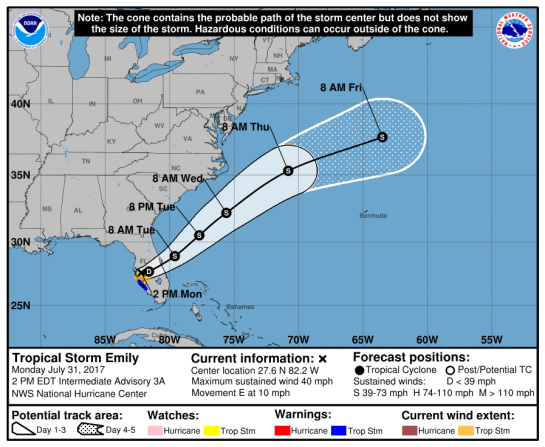
![[Image of 5-day forecast and coastal areas under a warning or a watch]](http://www.nhc.noaa.gov/storm_graphics/AT04/refresh/AL0414W5_NL_sm2+gif/204224W5_NL_sm.gif)


![[Image of 3-day forecast and coastal areas under a warning or a watch]](http://www.nhc.noaa.gov/storm_graphics/AT03/refresh/AL0314W_NL_sm2+gif/174431W_NL_sm.gif)


