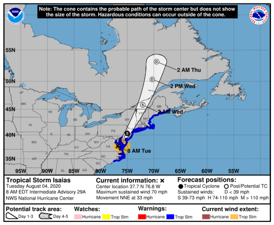
Tropical Storm ISAIAS (09L)
…………….CENTER OF ISAIAS MOVING RAPIDLY ACROSS EASTERN MARYLAND…
…STRONG WINDS…HEAVY RAINFALL…AND TORNADOES WILL CONTINUE TO
SPREAD NORTH-NORTHEASTWARD ALONG THE MID-ATLANTIC COAST TODAY………NHC FL
A Tropical Storm Warning is in effect for…
* North of Duck North Carolina to Eastport Maine
* Chesapeake Bay
* Tidal Potomac River
* Delaware Bay
* Long Island and Long Island Sound
* Martha’s Vineyard, Nantucket, and Block Island
CANADA: Isaias will approach Quebec and New Brunswick through New England tonight (Canadian Hurricane Centre)
National Hurricane Center (FL)


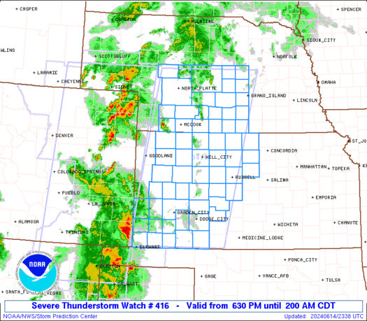
Source: https://www.spc.noaa.gov/products/watch/ww0416.html


ZCZC MIATCPAT4 ALL
TTAA00 KNHC DDHHMM
BULLETIN
Tropical Storm Isaias Advisory Number 30
NWS National Hurricane Center Miami FL AL092020
1100 AM EDT Tue Aug 04 2020
…CENTER OF ISAIAS MOVING RAPIDLY ACROSS EASTERN MARYLAND…
…STRONG WINDS…HEAVY RAINFALL…AND TORNADOES WILL CONTINUE TO
SPREAD NORTH-NORTHEASTWARD ALONG THE MID-ATLANTIC COAST TODAY…
SUMMARY OF 1100 AM EDT…1500 UTC…INFORMATION
———————————————–
LOCATION…39.1N 76.1W
ABOUT 20 MI…30 KM SSW OF FREDERICK MARYLAND
ABOUT 70 MI…110 KM SW OF PHILADELPHIA PENNSYLVANIA
MAXIMUM SUSTAINED WINDS…70 MPH…110 KM/H
PRESENT MOVEMENT…NNE OR 20 DEGREES AT 35 MPH…56 KM/H
MINIMUM CENTRAL PRESSURE…993 MB…29.33 INCHES
WATCHES AND WARNINGS
——————–
CHANGES WITH THIS ADVISORY:
The Tropical Storm Warning has been discontinued south of Duck,
North Carolina, including the Pamlico and Albemarle Sounds.
The Storm Surge Warning has been discontinued.
SUMMARY OF WATCHES AND WARNINGS IN EFFECT:
A Tropical Storm Warning is in effect for…
* North of Duck North Carolina to Eastport Maine
* Chesapeake Bay
* Tidal Potomac River
* Delaware Bay
* Long Island and Long Island Sound
* Martha’s Vineyard, Nantucket, and Block Island
A Tropical Storm Warning means that tropical storm conditions are
expected somewhere within the warning area, in this case
within the next 12 to 18 hours.
For storm information specific to your area, including possible
inland watches and warnings, please monitor products issued by your
local National Weather Service forecast office.
DISCUSSION AND OUTLOOK
———————-
At 1100 AM EDT (1500 UTC), the center of Tropical Storm Isaias was
located by NOAA Doppler weather radars and surface observations
near latitude 39.1 North, longitude 76.1 West. Isaias is moving
toward the north-northeast near 35 mph (56 km/h), and this general
motion accompanied by some increase in forward speed is expected
through tonight. On the forecast track, the center of Isaias will
continue to move near or along the coast of the mid-Atlantic states
today, and move across the northeastern United States into southern
Canada tonight.
Data from Doppler weather radars along with surface observations
indicate that maximum sustained winds remain near 70 mph (110 km/h)
with higher gusts. Only gradual weakening is anticipated while
Isaias moves north-northeastward near the mid-Atlantic coast today.
A faster rate of weakening is expected to begin tonight, and the
system is forecast to become post-tropical tonight or early
Wednesday.
Tropical-storm-force winds extend outward up to 140 miles (220 km)
from the center. During the past hour, a sustained wind of 55 mph
(89 km/h) and a gust to 65 mph (105 km/h) were reported by a
Weatherflow site at Ocean City, Maryland. A sustained wind of 45
mph (72 km/h) and a gust to 57 mph (92 km/h) were reported at Ocean
City-South Beach, New Jersey.
The estimated minimum central pressure based on surface
observations is 993 mb (29.33 inches).
HAZARDS AFFECTING LAND
———————-
Key messages for Isaias can be found in the Tropical Cyclone
Discussion under AWIPS header MIATCDAT4, WMO header WTNT44 KNHC,
and on the web at http://www.hurricanes.gov/text/MIATCDAT4.shtml.
STORM SURGE: The combination of storm surge and the tide will
cause normally dry areas near the coast to be flooded by rising
waters moving inland from the shoreline. The water could reach the
following heights above ground somewhere in the indicated areas if
the peak surge occurs at the time of high tide…
Ocracoke Inlet NC to the North Carolina/Virginia border including
Pamlico Sound, Albemarle Sound, Pamlico and Neuse Rivers…1-2 ft
North of the North Carolina/Virginia border to Martha’s Vineyard
including the Chesapeake Bay, the Tidal Potomac River, Delaware Bay,
Long Island Sound, Block Island Sound, Narragansett Bay, Buzzards
Bay, and Vineyard Sound…1-3 ft
The deepest water will occur along the immediate coast in areas of
onshore winds, where the surge will be accompanied by large waves.
Surge-related flooding depends on the relative timing of the surge
and the tidal cycle, and can vary greatly over short distances.
For information specific to your area, please see products issued
by your local National Weather Service forecast office.
WIND: Widespread tropical-storm conditions are expected in the
tropical storm warning area in the mid-Atlantic states, including
portions of the Chesapeake Bay region today, with wind gusts to
hurricane force possible. These winds could cause significant tree
damage and power outages.
Tropical storm conditions are expected to reach southern New
England this afternoon and northern New England tonight.
Gale-force winds are expected to spread into southeastern Quebec
tonight and Wednesday. See products issued by Environment
Canada for more information.
RAINFALL: The following rainfall accumulations are expected along
and near the track of Isaias:
Central and Northern Mid-Atlantic: Additional 2 to 4 inches,
isolated maximum storm totals of 8 inches.
Eastern New York into Vermont: 2 to 4 inches, isolated maximum
totals 6 inches.
Western Connecticut, western Massachusetts, New Hampshire and
western Maine: 1 to 3 inches.
Heavy rainfall along the East Coast, near the path of Isaias, will
result in flash and urban flooding, some of which may be significant
in the mid-Atlantic and Northeast through tonight. Potentially
life-threatening urban flooding remains possible Philadelphia, and
elsewhere along and just west of the I-95 corridor today. Scattered
minor to moderate river flooding is likely across portions of the
Mid-Atlantic. Quick-responding rivers in the Northeast will also be
susceptible to minor river flooding.
TORNADOES: A few tornadoes are possible across northern New Jersey
and southeastern New York, through southern New England, by late
afternoon. A risk for tornadoes may continue across northern New
England through this evening.
SURF: Swells generated by Isaias will spread northward along the
mid-Atlantic and Northeast coasts of the United States today. These
swells are likely to cause life-threatening surf and rip current
conditions. Please consult products from your local weather office.
NEXT ADVISORY
————-
Next intermediate advisory at 200 PM EDT.
Next complete advisory at 500 PM EDT.
$$
Forecaster Stewart
NNNN
Local info on Isaias: Wilmington NC, Raleigh NC, Newport/Morehead City NC, Wakefield VA, Baltimore/Washington, Philadelphia PA, New York NY, Albany NY, Boston MA, Portland ME, Caribou ME
CANADA

Tropical Cyclone Information Statements
8:36 AM ADT Tuesday 04 August 2020
Tropical cyclone information statement for:
New Brunswick
Québec – south:
- Amqui – Matapédia Valley
- Beauce
- Charlevoix
- Eastern Townships
- Forillon National Park – Gaspé – Percé
- Gaspésie National Park – Murdochville
- Kamouraska – Rivière-du-Loup – Trois-Pistoles
- Matane
- Montmagny – L’Islet
- New Carlisle – Chandler
- Québec
- Restigouche – Bonaventure
- Rimouski – Mont-Joli
- Sainte-Anne-des-Monts – Grande-Vallée
- Témiscouata
For Tropical Storm Isaias.
The next information statement will be issued by 2:00 p.m. EDT today.
1. Summary of basic information at 8:00 a.m. EDT.
Location: 37.7 North 76.8 West.
About 54 kilometres east-northeast of Richmond, VA.
Maximum sustained winds: 100 kilometres per hour.
Present movement: north-northeast at 46 kilometres per hour.
Minimum central pressure: 994 millibars.
2. Public weather impacts and warnings summary.
The Canadian Hurricane Centre is closely monitoring the progress of Tropical Storm Isaias (pronounced ees-ah-EE-ahs). Isaias will approach Quebec and New Brunswick through New England tonight. The expected impacts for Canada are heavy rainfall in southern and eastern parts of Quebec and moderate gusty winds including New Brunswick.
a. Wind.
Southeasterly winds gusting to 50 km/h are likely over New Brunswick and parts of Quebec including eastern Townships and areas along the St. Lawrence River tonight. As the low moves northward through Quebec Wednesday expect warm and humid southerly winds across the region. New Brunswick and the Gaspe region could see gusts up to 70 km/h Wednesday afternoon.
b. Rainfall.
A brief period of heavy rain from the direct remnants of the storm is expected over parts of southern Quebec after midnight tonight into early tomorrow morning. The eastern Townships northward to the Quebec City area is most likely to be affected with up to 60 mm. Most of the rain will fall over a short period of time (2-3 hours) therefore some minor flooding may occur in prone locations.
Additional note on rainfall as of Tuesday morning: Showers well ahead and to the west of the storm track throughout today are not directly related to Isaias. Also note that heavy rainfall may occur further west into the Montreal area as well due to a combination of Isaias’ remnants and a non-tropical low farther west.
c. Surge/Waves.
Nothing significant expected. Waves of 2-3 m along the southwestern portion of New Brunswick are expected tonight and into Wednesday.
3. Marine weather impacts and warnings summary.
Marginal gale-force winds can be expected over westernmost Maritime marine regions including the mouth of the St. Lawrence River tonight and into Wednesday. Seas of 2-3 metres are expected. Small craft operators should take precautions.
Forecasters: Fogarty/Spencer/Hatt
Please continue to monitor alerts issued by the Canadian Hurricane Centre and forecasts issued by Environment Canada.
For more comprehensive information about track tables and forecast rationale, please see the Technical Discussion
Source: Canadian Hurricane Centre (link)


TROPICAL STORM RISK
University College London, UK
STORM ALERT NOT AVAILABLE AT THIS TIME
For graphical forecast information and further details please visit http://www.tropicalstormrisk.com/
![]()
![]()
Current probability of tropical storm winds
![]()
Current probability of Cat 1 or above winds
![]()
MARITIME/SHIPPING
WTNT24 KNHC 041441
TCMAT4
TROPICAL STORM ISAIAS FORECAST/ADVISORY NUMBER 30
NWS NATIONAL HURRICANE CENTER MIAMI FL AL092020
1500 UTC TUE AUG 04 2020
CHANGES IN WATCHES AND WARNINGS WITH THIS ADVISORY…
THE TROPICAL STORM WARNING HAS BEEN DISCONTINUED SOUTH OF
DUCK…NORTH CAROLINA…INCLUDING THE PAMLICO AND ALBEMARLE SOUNDS.
THE STORM SURGE WARNING HAS BEEN DISCONTINUED.
SUMMARY OF WATCHES AND WARNINGS IN EFFECT…
A TROPICAL STORM WARNING IS IN EFFECT FOR…
* NORTH OF DUCK NORTH CAROLINA TO EASTPORT MAINE
* CHESAPEAKE BAY
* TIDAL POTOMAC RIVER
* DELAWARE BAY
* LONG ISLAND AND LONG ISLAND SOUND
* MARTHA’S VINEYARD…NANTUCKET…AND BLOCK ISLAND
A TROPICAL STORM WARNING MEANS THAT TROPICAL STORM CONDITIONS ARE
EXPECTED SOMEWHERE WITHIN THE WARNING AREA…IN THIS CASE
WITHIN THE NEXT 12 TO 18 HOURS.
TROPICAL STORM CENTER LOCATED NEAR 39.1N 76.1W AT 04/1500Z
POSITION ACCURATE WITHIN 25 NM
PRESENT MOVEMENT TOWARD THE NORTH-NORTHEAST OR 20 DEGREES AT 30 KT
ESTIMATED MINIMUM CENTRAL PRESSURE 993 MB
MAX SUSTAINED WINDS 60 KT WITH GUSTS TO 80 KT.
50 KT……. 60NE 60SE 0SW 0NW.
34 KT…….110NE 120SE 40SW 40NW.
12 FT SEAS..180NE 180SE 0SW 0NW.
WINDS AND SEAS VARY GREATLY IN EACH QUADRANT. RADII IN NAUTICAL
MILES ARE THE LARGEST RADII EXPECTED ANYWHERE IN THAT QUADRANT.
REPEAT…CENTER LOCATED NEAR 39.1N 76.1W AT 04/1500Z
AT 04/1200Z CENTER WAS LOCATED NEAR 37.7N 76.8W
FORECAST VALID 05/0000Z 43.2N 73.8W…INLAND
MAX WIND 50 KT…GUSTS 65 KT.
50 KT… 40NE 70SE 20SW 0NW.
34 KT…120NE 180SE 40SW 40NW.
FORECAST VALID 05/1200Z 48.2N 71.7W…POST-TROP/INLAND
MAX WIND 35 KT…GUSTS 45 KT.
34 KT… 0NE 180SE 0SW 0NW.
FORECAST VALID 06/0000Z 52.0N 71.1W…POST-TROP/EXTRATROP
MAX WIND 30 KT…GUSTS 40 KT.
FORECAST VALID 06/1200Z 53.6N 69.5W…POST-TROP/EXTRATROP
MAX WIND 20 KT…GUSTS 30 KT.
FORECAST VALID 07/0000Z…DISSIPATED
REQUEST FOR 3 HOURLY SHIP REPORTS WITHIN 300 MILES OF 39.1N 76.1W
INTERMEDIATE PUBLIC ADVISORY…WTNT34 KNHC/MIATCPAT4…AT 04/1800Z
NEXT ADVISORY AT 04/2100Z
$$
FORECASTER STEWART
CANADA
- Marine Weather Warnings
- Latest Satellite images
- Latest Radar Image
=========================================================================

