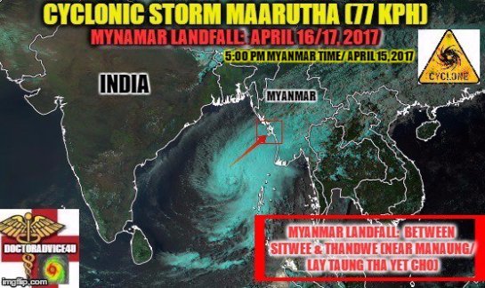
Tropical Cyclone Frances (29U, 17S)
Intensity Category 1 Cyclone Frances is moving southwest across the Timor Sea tonight and is slowly intensifying (BOM NT TCWC)
MAXIMUM SIGNIFICANT WAVE HEIGHT AT 270000ZIS 10 FEET (JTWC)

IDD20150
Australian Government Bureau of Meteorology
Northern Territory
Tropical Cyclone Warning Centre
Media: The Standard Emergency Warning Signal should NOT be used with this warning.
TOP PRIORITY FOR IMMEDIATE BROADCAST
TROPICAL CYCLONE WARNING
TROPICAL CYCLONE ADVICE NUMBER 2
Issued at 10:54 pm ACST [9:24 pm AWST] on Thursday 27 April 2017
Headline:
Category 1 Cyclone Frances is moving southwest across the Timor Sea tonight and is slowly intensifying.
Areas Affected:
Warning Zone
Kuri Bay to Wyndham, not including Wyndham.
Watch Zone
None.
Cancelled Zone
None.
Details of Tropical Cyclone Frances at 9:30 pm ACST [8:00 pm AWST]:
Intensity: Category 1, sustained winds near the centre of 85 kilometres per hour with wind gusts to 120 kilometres per hour.
Location: within 55 kilometres of 11.0 degrees South 128.3 degrees East, estimated to be 235 kilometres west of Pirlangimpi and 410 kilometres north northeast of Kalumburu.
Movement: west southwest at 19 kilometres per hour.
Tropical Cyclone Frances is expected to intensify as it moves southwest through the Timor Sea tonight, possibly developing into a Category 2 system early on Friday. The cyclone is expected to remain over water as it heads towards the Indian Ocean, however If it takes a more southerly track peripheral gales may affect the north Kimberley coast later on Friday.
Hazards:
GALES with gusts to 110 kilometres per hour may develop in coastal parts between Kuri Bay and Wyndham, not including Wyndham, later on Friday.
Tides between Kalumburu and Wyndham are likely to rise above normal high tide mark with very rough seas and flooding of low-lying coastal areas.
Recommended Action:
DFES-State Emergency Service advises that there are no community alerts at present.
People in the Kimberley are advised to stay up to date with weather forecasts and warnings.
People between Kuri Bay and Wyndham should listen for the next advice.
People needing DFES assistance can call 132 500. In a life threatening situation call 000.
For more safety tips visit http://www.dfes.wa.gov.au.
Next Advice:
The next advice will be issued by 2:00 am ACST Friday 28 April [12:30 am AWST Friday 28 April].
This advice is available on telephone NT-1300 659 211 and WA-1300 659 210
=================================================================================
IDJ21031
CLIMATOLOGY AND GEOPHYSICS AND METEOROLOGICAL AGENCY
Tropical Cyclone Warning Centre (TCWC) In Jakarta
TROPICAL CYCLONE INFORMATION BULLETIN
Issued by the TROPICAL CYCLONE WARNING CENTER JAKARTA
In: 17:05 EST 27/04/2017
Tropical Cyclone FRANCES
The condition of the date 27/04/2017 at 13:00 PM EST:
Position: 10, 1LS, 129, 4BT (about 630 km east of Kupang)
The direction of motion: West-Southwest, the speed of 8 knots (15 km/h) and move towards the region of Indonesia
Speed
Maximum wind: 35 knots (65 km/h)
24-hour predictions, date 28/04/2017 at 13:00 PM EST:
Position: 11, 2LS, 126, 6BT (about 340 km east southeast of Kupang)
The direction of motion: moving away from the southwestern region of Indonesia
Speed
Wind maximum: 55 knots (100 km/h)
Prediction of 48 hours, the date of 29/04/2017 at 13:00 PM EST:
Position: 12, 2LS, 123, 5BT
The direction of motion: moving away from the southwestern region of Indonesia
Speed
Wind maximum: 40 knots (75 km/h)
72 hours predictions, date 30/04/2017 at 13:00 PM EST:
Position: 13, 0LS, 121, 0BT
The direction of motion: moving away from the southwestern region of Indonesia
Speed
Maximum: wind 20 knots (35 km/h)
IMPACT ON THE WEATHER IN INDONESIA:
Tropical cyclone FRANCES gave impact on weather conditions in the region of Indonesia in the form of:
–Rain with medium intensity up to thick on the territory of NTT and the southern and Southeast Maluku.
–Waves with a height of 1.25–2.5 meters in territorial waters south of Sumba, Bali Strait, Lombok Strait, Selat Alas southern waters of the island of Savu sea, Savu sea, Southern Ocean Waters up to Sermata Islands Sea, Arafuru Leti Central and Eastern parts, and the Indian Ocean south of the NTB.
–Waves with a height of 2.5-4 meters in territorial waters south of Kupang, Timor Sea, Arafuru Sea and parts of the West.
IDJ21031
BADAN METEOROLOGI KLIMATOLOGI DAN GEOFISIKA
Tropical Cyclone Warning Centre (TCWC) Jakarta
BULETIN INFORMASI SIKLON TROPIS
Dikeluarkan oleh TROPICAL CYCLONE WARNING CENTRE JAKARTA
Pada: 17:05 WIB 27/04/2017
Siklon Tropis FRANCES
Kondisi tanggal 27/04/2017 pukul 13:00 WIB :
Posisi : 10,1LS, 129,4BT (sekitar 630 km sebelah timur Kupang)
Arah Gerak : barat barat daya, kecepatan 8 knots (15 km/jam) bergerak menuju wilayah Indonesia
Kecepatan
Angin Maksimum: 35 knots (65 km/jam)
Prediksi 24 jam, tanggal 28/04/2017 pukul 13:00 WIB :
Posisi : 11,2LS, 126,6BT (sekitar 340 km sebelah timur tenggara Kupang)
Arah Gerak : Barat daya bergerak menjauhi wilayah Indonesia
Kecepatan
Angin Maksimum: 55 knots (100 km/jam)
Prediksi 48 jam, tanggal 29/04/2017 pukul 13:00 WIB :
Posisi : 12,2LS, 123,5BT
Arah Gerak : Barat daya bergerak menjauhi wilayah Indonesia
Kecepatan
Angin Maksimum: 40 knots (75 km/jam)
Prediksi 72 jam, tanggal 30/04/2017 pukul 13:00 WIB :
Posisi : 13,0LS, 121,0BT
Arah Gerak : Barat daya bergerak menjauhi wilayah Indonesia
Kecepatan
Angin Maksimum: 20 knots (35 km/jam)
DAMPAK TERHADAP CUACA DI INDONESIA :
Siklon tropis FRANCES memberikan dampak terhadap kondisi cuaca di wilayah Indonesia berupa :
– Hujan dengan intensitas sedang hingga lebat di wilayah NTT dan Maluku bagian selatan dan Tenggara.
– Gelombang dengan ketinggian 1.25 – 2.5 meter di wilayah Perairan selatan Sumba, Selat Bali, Selat Lombok, Selat Alas bagian selatan, Perairan Pulau Sawu, Laut Sawu bagian selatan, Perairan Kepulauan Sermata hingga Leti, Laut Arafuru bagian tengah dan timur, dan Samudera Hindia selatan NTB.
– Gelombang dengan ketinggian 2.5 – 4 meter di wilayah Perairan selatan Kupang, Laut Timor, dan Laut Arafuru bagian barat.

Joint Typhoon Warning Center (JTWC)

Google Earth Overlay 
WTXS31 PGTW 270300
MSGID/GENADMIN/JOINT TYPHOON WRNCEN PEARL HARBOR HI//
SUBJ/TROPICAL CYCLONE 17S (SEVENTEEN) WARNING NR 001//
REF/A/MSG/JOINT TYPHOON WRNCEN PEARL HARBOR HI/260251ZAPR2017//
AMPN/REF A IS A TROPICAL CYCLONE FORMATION ALERT.//
RMKS/
1. TROPICAL CYCLONE 17S (SEVENTEEN) WARNING NR 001
01 ACTIVE TROPICAL CYCLONE IN SOUTHIO
MAX SUSTAINED WINDS BASED ON ONE-MINUTE AVERAGE
WIND RADII VALID OVER OPEN WATER ONLY
—
WARNING POSITION:
270000Z — NEAR 9.6S 130.2E
MOVEMENT PAST SIX HOURS – 225 DEGREES AT 08 KTS
POSITION ACCURATE TO WITHIN 020 NM
POSITION BASED ON CENTER LOCATED BY SATELLITE
PRESENT WIND DISTRIBUTION:
MAX SUSTAINED WINDS – 035 KT, GUSTS 045 KT
WIND RADII VALID OVER OPEN WATER ONLY
RADIUS OF 034 KT WINDS – 045 NM NORTHEAST QUADRANT
065 NM SOUTHEAST QUADRANT
060 NM SOUTHWEST QUADRANT
040 NM NORTHWEST QUADRANT
REPEAT POSIT: 9.6S 130.2E
—
FORECASTS:
12 HRS, VALID AT:
271200Z — 10.2S 128.9E
MAX SUSTAINED WINDS – 040 KT, GUSTS 050 KT
WIND RADII VALID OVER OPEN WATER ONLY
RADIUS OF 034 KT WINDS – 050 NM NORTHEAST QUADRANT
105 NM SOUTHEAST QUADRANT
095 NM SOUTHWEST QUADRANT
040 NM NORTHWEST QUADRANT
VECTOR TO 24 HR POSIT: 245 DEG/ 08 KTS
—
24 HRS, VALID AT:
280000Z — 10.8S 127.5E
MAX SUSTAINED WINDS – 045 KT, GUSTS 055 KT
WIND RADII VALID OVER OPEN WATER ONLY
RADIUS OF 034 KT WINDS – 045 NM NORTHEAST QUADRANT
110 NM SOUTHEAST QUADRANT
090 NM SOUTHWEST QUADRANT
040 NM NORTHWEST QUADRANT
VECTOR TO 36 HR POSIT: 245 DEG/ 09 KTS
—
36 HRS, VALID AT:
281200Z — 11.6S 125.9E
MAX SUSTAINED WINDS – 045 KT, GUSTS 055 KT
WIND RADII VALID OVER OPEN WATER ONLY
RADIUS OF 034 KT WINDS – 015 NM NORTHEAST QUADRANT
110 NM SOUTHEAST QUADRANT
050 NM SOUTHWEST QUADRANT
020 NM NORTHWEST QUADRANT
VECTOR TO 48 HR POSIT: 245 DEG/ 07 KTS
—
EXTENDED OUTLOOK:
48 HRS, VALID AT:
290000Z — 12.2S 124.6E
MAX SUSTAINED WINDS – 040 KT, GUSTS 050 KT
WIND RADII VALID OVER OPEN WATER ONLY
RADIUS OF 034 KT WINDS – 015 NM NORTHEAST QUADRANT
085 NM SOUTHEAST QUADRANT
050 NM SOUTHWEST QUADRANT
020 NM NORTHWEST QUADRANT
VECTOR TO 72 HR POSIT: 245 DEG/ 05 KTS
—
72 HRS, VALID AT:
300000Z — 13.0S 122.6E
MAX SUSTAINED WINDS – 035 KT, GUSTS 045 KT
WIND RADII VALID OVER OPEN WATER ONLY
DISSIPATING AS A SIGNIFICANT TROPICAL CYCLONE OVER WATER
RADIUS OF 034 KT WINDS – 015 NM NORTHEAST QUADRANT
065 NM SOUTHEAST QUADRANT
035 NM SOUTHWEST QUADRANT
020 NM NORTHWEST QUADRANT
VECTOR TO 96 HR POSIT: 255 DEG/ 04 KTS
—
LONG RANGE OUTLOOK:
—
96 HRS, VALID AT:
010000Z — 13.4S 121.1E
MAX SUSTAINED WINDS – 030 KT, GUSTS 040 KT
WIND RADII VALID OVER OPEN WATER ONLY
DISSIPATED AS A SIGNIFICANT TROPICAL CYCLONE OVER WATER
—
REMARKS:
270300Z POSITION NEAR 9.7S 129.9E.
TROPICAL CYCLONE (TS) 17S (SEVENTEEN), LOCATED APPROXIMATELY 179 NM
NORTH-NORTHWEST OF DARWIN, AUSTRALIA, HAS TRACKED SOUTHWESTWARD
AT 08 KNOTS OVER THE PAST SIX HOURS. ANIMATED MULTISPECTRAL
SATELLITE IMAGERY DEPICTS A PARTIALLY EXPOSED LOW LEVEL CIRCULATION
CENTER (LLCC) WITH DEEP FLARING CONVECTION ALONG THE SOUTHERN
PERIPHERY. A 270102Z ASCAT BULLSEYE SHOWS A DEFINED LLCC WITH 35
KNOT WINDS ALONG THE SOUTHERN SIDE WRAPPING INTO THE CENTER. THE
CURRENT POSITION AND INTENSITY ARE BASED ON THE SCATTEROMETER PASS
WITH HIGH CONFIDENCE. ENVIRONMENTAL CONDITIONS ARE
FAVORABLE WITH LOW TO MODERATE VERTICAL WIND SHEAR, STRONG DIVERGENT
OUTFLOW AND WARM SEA SURFACE TEMPERATURES. TS 17S IS TRACKING ALONG
THE NORTHERN PERIPHERY OF AN EXTENSION OF THE SUB-TROPICAL RIDGE
LOCATED TO THE EAST. THE FAVORABLE ENVIRONMENT WILL SUPPORT A PERIOD
OF INTENSIFICATION OVER THE NEXT 24 HOURS AS THE CYCLONE TRACKS
WESTWARD. AFTERWARDS, INCREASING VWS WILL BEGIN TO WEAKEN THE
CYCLONE AND LEAD TO ITS COMPLETE DISSIPATION BY THE END OF THE
FORECAST PERIOD. AVAILABLE MODEL GUIDANCE IS IN PRETTY GOOD
AGREEMENT OVER THE FIRST 36 HOURS BUT BEGIN TO DIVERGE AS THE
CYCLONE WEAKENS. THIS DIVERGENCE IN GUIDANCE LENDS LOW CONFIDENCE IN
THE JTWC FORECAST TRACK. MAXIMUM SIGNIFICANT WAVE HEIGHT AT 270000Z
IS 10 FEET. NEXT WARNINGS AT 271500Z AND 280300Z. THIS CANCELS AND
SUPERSEDES REF A (WTXS21 PGTW 260300).//
NNNN
S Indian Ocean: TSR Storm Alert issued at 27 Apr, 2017 12:00 GMT
Tropical Storm FRANCES is currently located near 10.9 S 128.4 E with maximum 1-min sustained winds of 45kts (52 mph). FRANCES is forecast to affect land to the following likelihood(s) at the given lead time(s):
Green Alert Country(s) or Province(s)
Australia
probability for TS is 50% within 12 hours
Green Alert City(s) and Town(s)
Kalumburu (14.2 S, 126.6 E)
probability for TS is 40% in about 24 hours
Note that
Green Alert (Low) is TS to between 31% and 50% probability.
TS means Tropical Storm strength winds of at least 39 mph, 63 km/h or 34 knots 1-min sustained.

(Image: TSR)
MARITIME/SHIPPING
METAREA10 / TROPICAL_CYCLONE_WARNING_DARWIN / 1339
WTAU03 ADRM 271339 RRB
WINDS TO 50 KNOTS NEAR CENTRE.
AT 1200 UTC 28 APRIL: WITHIN 80 NAUTICAL MILES OF 11.8 SOUTH 124.7
EAST
CENTRAL PRESSURE 990 HPA.
WINDS TO 55 KNOTS NEAR CENTRE.
REMARKS
ALL SHIPS IN THE AREA PLEASE SEND WEATHER REPORTS EVERY THREE HOURS.
REGULAR WEATHER OBSERVING SHIPS USE NORMAL CHANNELS.
OTHER SHIPS PLEASE USE EITHER EMAIL TO NTTCWC.BOM.GOV.AU OR FAX TO
+6189203829
OR SATELLITE USING SAC1241 THROUGH LAND EARTH STATION BURUM 312 .OR
212 AS
APPROPRIATE. VIA PERTH.
NEXT WARNING WILL BE ISSUED BY 1930 UTC 27 APRIL 2017.
DARWIN TROPICAL CYCLONE WARNING CENTRE
IDD20020
TROPICAL CYCLONE TECHNICAL BULLETIN: AUSTRALIA – NORTHERN REGION
Issued by DARWIN TROPICAL CYCLONE WARNING CENTRE
at: 1404 UTC 27/04/2017
Name: Tropical Cyclone Frances
Identifier: 29U
Data At: 1200 UTC
Latitude: 11.0S
Longitude: 128.3E
Location Accuracy: within 30 nm [55 km]
Movement Towards: west southwest [241 deg]
Speed of Movement: 10 knots [19 km/h]
Maximum 10-Minute Wind: 45 knots [85 km/h]
Maximum 3-Second Wind Gust: 65 knots [120 km/h]
Central Pressure: 994 hPa
Radius of 34-knot winds NE quadrant: 30 nm [55 km]
Radius of 34-knot winds SE quadrant: 75 nm [140 km]
Radius of 34-knot winds SW quadrant: 75 nm [140 km]
Radius of 34-knot winds NW quadrant: 30 nm [55 km]
Radius of 48-knot winds NE quadrant:
Radius of 48-knot winds SE quadrant:
Radius of 48-knot winds SW quadrant:
Radius of 48-knot winds NW quadrant:
Radius of 64-knot winds:
Radius of Maximum Winds: 25 nm [45 km]
Dvorak Intensity Code: T3.0/3.0/D1.5/24HRS
Pressure of outermost isobar: 1008 hPa
Radius of outermost closed isobar: 150 nm [280 km]
FORECAST DATA
Date/Time : Location : Loc. Accuracy: Max Wind : Central Pressure
[UTC] : degrees : nm [km]: knots[km/h]: hPa
+06: 27/1800: 11.2S 127.4E: 040 [080]: 050 [095]: 993
+12: 28/0000: 11.5S 126.4E: 055 [100]: 050 [095]: 992
+18: 28/0600: 11.7S 125.6E: 065 [125]: 055 [100]: 990
+24: 28/1200: 11.8S 124.7E: 080 [145]: 055 [100]: 990
+36: 29/0000: 12.4S 122.9E: 100 [180]: 045 [085]: 996
+48: 29/1200: 12.8S 121.5E: 120 [220]: 035 [065]: 1000
+60: 30/0000: 13.1S 120.3E: 140 [255]: 030 [055]: 1002
+72: 30/1200: 13.2S 119.3E: 155 [290]: 025 [045]: 1005
+96: 01/1200: 13.2S 118.1E: 200 [370]: 025 [045]: 1004
+120: 02/1200: 12.8S 116.7E: 290 [535]: 025 [045]: 1006
REMARKS:
The 12Z position of Tropical Cyclone Frances was made with reasonable confidence
based on recent microwave passes and infra-red imagery.
Intensity was based on a shear pattern with low level centre having moved
underneath the dense overcast, giving a DT of 3.5. Development over the last 24
hours has been D+, giving a MET of 3.0, PAT of 3.0 with Final T at 3.0. Ascat
pass at 0103 UTC indicated winds of 30-35 knots on the southern side.
The cyclone is located in a moist environment in a diffluent upper-level outflow
pattern just north of the upper level ridge. This is creating strong upper-level
divergence with twin outflow channels seen in recent satellite imagery. Earlier
in the day the system moved into a more favourable low shear environment. This,
in conjunction with the arrival of a strong east to southeasterly surge from a
developing ridge over Australia, has sustained continued development of the
cyclone.
Model consensus suggest the cyclone will move towards the southwest over the
next few days due to mid level ridges located to the south and east. On this
southwesterly track, the system is expected to remain in a low sheared
environment and in a diffluent upper pattern, with even a chance of rapid
development. There is a small chance though that the system could turn more
towards the west into an increasingly sheared environment. Dry air intrusion may
also limit development in the short term.
From later Saturday, the cyclone is expected to move into a higher shear
environment, due to a mid to upper level trough approaching from the west, with
dry air entrainment weakening the system to below Tropical Cyclone strength.
Copyright Commonwealth of Australia
==
The next bulletin for this system will be issued by: 27/2000 UTC by Darwin TCWC.
Do not use any information on this site for life or death decisions. All information is intended as supplementary to official sources. Kindly refer to your country’s official weather agency/government website for local warnings, advisories and bulletins.