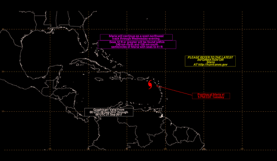
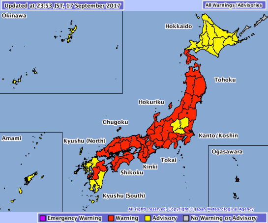
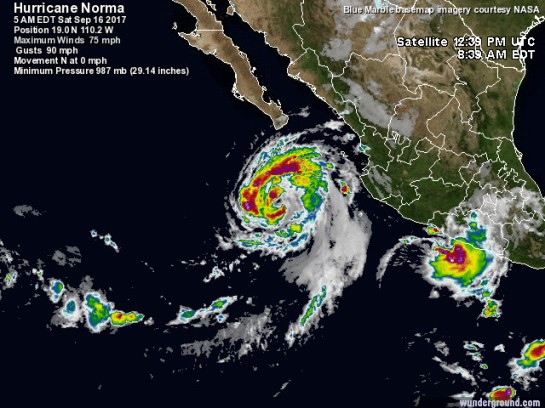
…LIDIA’S CENTER JUST OFFSHORE THE SOUTHWESTERN COAST OF BAJA
CALIFORNIA SUR…
…HEAVY RAINS CONTINUE OVER SOUTHERN BAJA CALIFORNIA SUR…
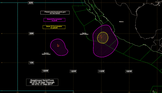
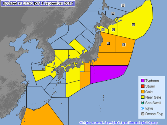
A Tropical Storm Warning is in effect for…
* Baja California peninsula from San Jose de Las Palomas to Isla
San Luis
* Mainland Mexico from Altata to Puerto Libertad
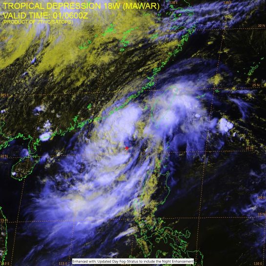
(Image: @wunderground)
(Image: @wunderground)
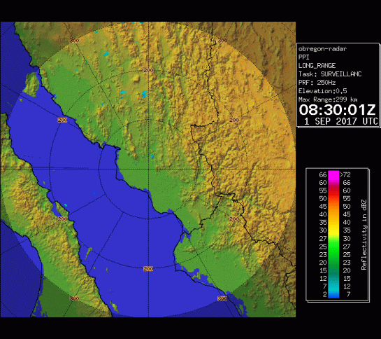
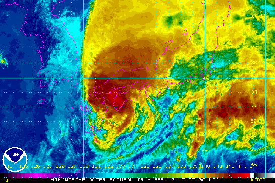
Obregón Radar Mexico
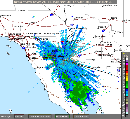
NWS radar Image from Yuma, AZ
National Hurricane Center (FL)
000
WTPZ34 KNHC 010846
TCPEP4
BULLETIN
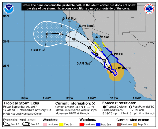
Tropical Storm Lidia Advisory Number 11
NWS National Hurricane Center Miami FL EP142017
300 AM MDT Fri Sep 01 2017
…LIDIA’S CENTER JUST OFFSHORE THE SOUTHWESTERN COAST OF BAJA
CALIFORNIA SUR…
…HEAVY RAINS CONTINUE OVER SOUTHERN BAJA CALIFORNIA SUR…
SUMMARY OF 300 AM MDT…0900 UTC...INFORMATION
———————————————-
LOCATION…23.8N 111.0W
ABOUT 50 MI…85 KM WSW OF LA PAZ MEXICO
ABOUT 105 MI…170 KM SE OF CABO SAN LAZARO MEXICO
MAXIMUM SUSTAINED WINDS…65 MPH…100 KM/H
PRESENT MOVEMENT…NW OR 325 DEGREES AT 8 MPH…13 KM/H
MINIMUM CENTRAL PRESSURE…987 MB…29.15 INCHES
WATCHES AND WARNINGS
——————–
CHANGES WITH THIS ADVISORY:
The government of Mexico has extended the Tropical Storm Warning on
the west coast of the Baja California peninsula northward to San
Jose de Las Palomas, on the east coast northward to Isla San
Luis, and along the coast of mainland Mexico northward to Puerto
Libertad.
The government of Mexico has discontinued the Hurricane Watch for
Baja California Sur, as well as the Tropical Storm Warning south of
Altata on the coast of mainland Mexico.
SUMMARY OF WATCHES AND WARNINGS IN EFFECT:
A Tropical Storm Warning is in effect for…
* Baja California peninsula from San Jose de Las Palomas to Isla
San Luis
* Mainland Mexico from Altata to Puerto Libertad
A Tropical Storm Warning means that tropical storm conditions are
expected somewhere within the warning area within 36 hours.
Interests elsewhere in western Mexico and the Baja California
peninsula should monitor the progress of Lidia.
For storm information specific to your area, please monitor
products issued by your national meteorological service.
DISCUSSION AND 48-HOUR OUTLOOK
——————————
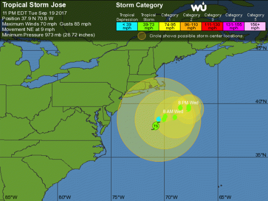
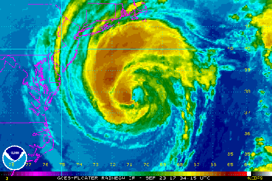
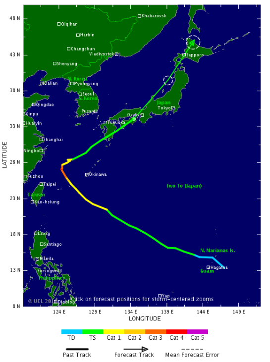
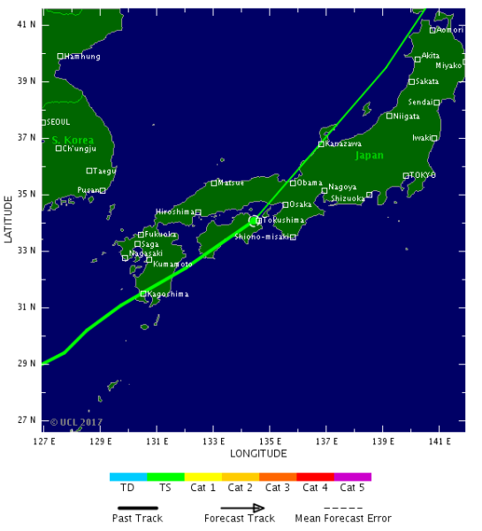
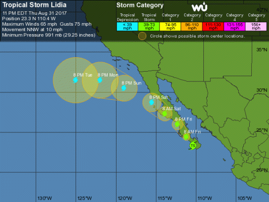
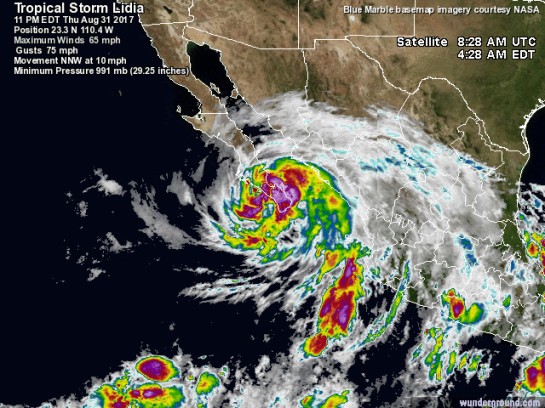
At 300 AM MDT (0900 UTC), the center of Tropical Storm Lidia was
located near latitude 23.8 North, longitude 111.0 West. Lidia is
moving toward the northwest near 8 mph (13 km/h), and this
direction with an increase in forward speed is expected through
Saturday night. On the forecast track, the center of Lidia will
move near or along the west coast of the Baja California peninsula
through Saturday and then move west of the peninsula over the
Pacific waters Saturday night.
Maximum sustained winds are near 65 mph (100 km/h) with higher
gusts. Weakening is forecast during the next couple of days while
Lidia interacts with the mountainous terrain of the Baja California
peninsula. Lidia is expected to become a remnant low by Saturday
night.
Tropical-storm-force winds extend outward up to 195 miles (315 km),
especially to the northeast and southeast of the center.
The estimated minimum central pressure is 987 mb (29.15 inches).
HAZARDS AFFECTING LAND
———————-
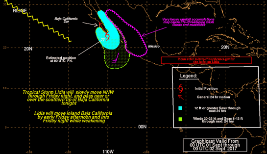
RAINFALL: Lidia is expected to produce total rain accumulations of
6 to 12 inches across the Mexican states of Baja California Sur into
Baja California, Sinaloa, and the coastal section of Sonora, with
isolated maximum amounts of 20 inches. These rains may cause
life-threatening flash floods and mudslides. Some of the tropical
moisture from Lidia may reach parts of the Desert Southwest this
holiday weekend, including southern California, southern Nevada, and
southwestern Arizona.
WIND: Tropical storm conditions are occurring over the southern
portion of Baja California Sur at this time. These conditions
should spread northward across the warning areas of the Baja
California peninsula and mainland Mexico through Saturday. Wind
speeds atop and on the windward sides of hills and mountains are
often up to 30 percent stronger than the near-surface winds
indicated in this advisory, and in some elevated locations could be
even greater.
STORM SURGE: A dangerous storm surge is expected to produce coastal
flooding in areas of onshore winds on the southern portion of Baja
California Sur. Near the coast, the surge will be accompanied by
large and destructive waves.
SURF: Swells generated by Lidia are affecting portions of the coast
of southwestern and western Mexico and southern portions of Baja
California Sur, and could cause life-threatening surf and rip
current conditions. Please consult products from your local weather
office.
NEXT ADVISORY
————-
Next intermediate advisory at 600 AM MDT.
Next complete advisory at 900 AM MDT.
$$
Forecaster Berg
=============================================================================
MARITIME/SHIPPING
METAREA12 / HURRICANE_ADVISORY / 1436
WTPZ24 KNHC 010845 RRA
TCMEP4
TROPICAL STORM LIDIA FORECAST/ADVISORY NUMBER 11
NWS NATIONAL HURRICANE CENTER MIAMI FL EP142017
0900 UTC FRI SEP 01 2017
CHANGES IN WATCHES AND WARNINGS WITH THIS ADVISORY…
THE GOVERNMENT OF MEXICO HAS EXTENDED THE TROPICAL STORM WARNING ON
THE WEST COAST OF THE BAJA CALIFORNIA PENINSULA NORTHWARD TO SAN
JOSE DE LAS PALOMAS… ON THE EAST COAST NORTHWARD TO ISLA SAN
LUIS… AND ALONG THE COAST OF MAINLAND MEXICO NORTHWARD TO PUERTO
LIBERTAD.
THE GOVERNMENT OF MEXICO HAS DISCONTINUED THE HURRICANE WATCH FOR
BAJA CALIFORNIA SUR… AS WELL AS THE TROPICAL STORM WARNING SOUTH
OF ALTATA ON THE COAST OF MAINLAND MEXICO.
SUMMARY OF WATCHES AND WARNINGS IN EFFECT…
A TROPICAL STORM WARNING IS IN EFFECT FOR…
. BAJA CALIFORNIA PENINSULA FROM SAN JOSE DE LAS PALOMAS TO ISLA
SAN LUIS
… MAINLAND MEXICO FROM ALTATA TO PUERTO LIBERTAD
A TROPICAL STORM WARNING MEANS THAT TROPICAL STORM CONDITIONS ARE
EXPECTED SOMEWHERE WITHIN THE WARNING AREA WITHIN 36 HOURS.
INTERESTS ELSEWHERE IN WESTERN MEXICO AND THE BAJA CALIFORNIA
PENINSULA SHOULD MONITOR THE PROGRESS OF LIDIA.
TROPICAL STORM CENTER LOCATED NEAR 23.8N 111.0W AT 01/0900Z
POSITION ACCURATE WITHIN 40 NM
PRESENT MOVEMENT TOWARD THE NORTHWEST OR 325 DEGREES AT 7 KT
ESTIMATED MINIMUM CENTRAL PRESSURE 987 MB
MAX SUSTAINED WINDS 55 KT WITH GUSTS TO 65 KT.
50 KT……. 30NE 30SE 0SW 30NW.
34 KT…….170NE 130SE 50SW 60NW.
12 FT SEAS..180NE 240SE 90SW 90NW.
WINDS AND SEAS VARY GREATLY IN EACH QUADRANT. RADII IN NAUTICAL
MILES ARE THE LARGEST RADII EXPECTED ANYWHERE IN THAT QUADRANT.
REPEAT…CENTER LOCATED NEAR 23.8N 111.0W AT 01/0900Z
FZPN02 KWBC 010525
HSFEPI
HIGH SEAS FORECAST FOR METAREA XII
NWS OCEAN PREDICTION CENTER WASHINGTON DC
0545 UTC FRI SEP 01 2017
CCODE/1:31:12:01:00/AOW+POR/NWS/CCODE
SUPERSEDED BY NEXT ISSUANCE IN 6 HOURS
SEAS GIVEN AS SIGNIFICANT WAVE HEIGHT…WHICH IS THE AVERAGE
HEIGHT OF THE HIGHEST 1/3 OF THE WAVES. INDIVIDUAL WAVES MAY
BE MORE THAN TWICE THE SIGNIFICANT WAVE HEIGHT.
SECURITE
PACIFIC N OF 30N AND S OF 67N E OF A LINE FROM BERING STRAIT
TO 50N 160E
SYNOPSIS VALID 0000 UTC SEP 01.
24 HOUR FORECAST VALID 0000 UTC SEP 02.
48 HOUR FORECAST VALID 0000 UTC SEP 03.
.WARNINGS.
…GALE WARNING…
.LOW 50N174E 1008 MB MOVING E 25 KT. FROM 42N TO 49N BETWEEN
178W AND 170E WINDS 20 TO 30 KT. SEAS TO 8 FT. OVER FORECAST
WATERS WITHIN 540 NM S QUADRANT WINDS TO 25 KT. SEAS LESS THAN 8
FT.
.24 HOUR FORECAST LOW 49N172W 1002 MB. FRONT TO EXTEND FROM
49N169W TO 45N169W TO 40N172W. WITHIN 120 NM E OF FRONT WINDS 25
TO 35 KT. SEAS TO 12 FT. ELSEWHERE FROM 38N TO 50N BETWEEN 163W
AND 179W WINDS 20 TO 30 KT. SEAS TO 9 FT.
.48 HOUR FORECAST COMPLEX LOW WITH MAIN LOW 53N162W 977 MB.
FRONT TO EXTEND FROM 55N159W TO 50N157W TO SECOND LOW 47N159W
985 MB TO 40N169W. WITHIN 120 NM N AND NW SEMICIRCLES MAIN LOW
AND 300 NM E AND SE OF FRONT WINDS 35 TO 45 KT. SEAS 12 TO 21
FT. ELSEWHERE WITHIN 360 NM N…600 NM E AND W AND 960 NM S
QUADRANTS MAIN LOW WINDS 25 TO 35 KT. SEAS 8 TO 13 FT.
.SYNOPSIS AND FORECAST.
.BOGOSLOF VOLCANO AT 53.92N 168.03W IS CURRENTLY IN A HEIGHTENED
STATE OF UNREST AND REMAINS ACTIVE. MARINERS TRAVELING IN THE
VICINITY OF BOGOSLOF VOLCANO ARE URGED TO EXERCISE CAUTION. IF
MARINERS ENCOUNTER ANY VOLCANIC ASH…REPORT THE OBSERVATION TO
THE OCEAN PREDICTION CENTER BY CALLING 301-683-1520.
.FROM 31N TO 45N BETWEEN 122W AND 129W AREA OF N TO NW WINDS 20
TO 30 KT. SEAS TO 12 FT.
.24 HOUR FORECAST WITHIN 240 NM E OF A LINE FROM 37N134W TO
43N130W TO 47N126W AREA OF N WINDS 20 TO 30 KT. SEAS TO 12 FT.
.48 HOUR FORECAST WITHIN FROM 42N TO 48N E OF 129W AREA OF N TO
NE WINDS TO 25 KT. SEAS TO 9 FT.
.FROM 54N TO 59N BETWEEN 148W AND 162W WINDS TO 25 KT. SEAS TO 8
FT.
.24 HOUR FORECAST CONDITIONS DIMINISHED.
.LOW 56N169W 1006 MB MOVING E 15 KT. WITHIN 120 NM SE AND 180 NM
SW QUADRANTS WINDS TO 25 KT. SEAS TO 8 FT.
.24 HOUR FORECAST LOW DISSIPATED WITH CONDITIONS DIMINISHED.
.FROM 51N TO 56N BETWEEN 131W AND 138W WINDS TO 25 KT. SEAS TO
11 FT.
.24 HOUR FORECAST CONDITIONS DIMINISHED.
.LOW 45N144W 1012 MB MOVING NE 35 KT. FRONT EXTENDS FROM 48N135W
TO LOW TO 31N162W. WITHIN 300 NM E OF FRONT WINDS TO 25 KT. SEAS
TO 8 FT.
.24 HOUR FORECAST LOW INLAND. FRONT TO EXTEND FROM 49N136W TO
42N145W TO 34N154W. WITHIN 120 NM EITHER SIDE OF FRONT WINDS TO
25 KT. SEAS TO 9 FT.
.48 HOUR FORECAST NEW LOW 42N146W 1008 MB. WITHIN 240 NM SE
SEMICIRCLE WINDS 20 TO 30 KT. SEAS TO 9 FT.
.LOW NW OF AREA 58N163E 994 MB MOVING SE 25 KT. OVER FORECAST
WATERS WITHIN 420 NM SE QUADRANT WINDS TO 25 KT. SEAS LESS THAN
8 FT.
.24 HOUR FORECAST LOW 56N178W 996 MB. FROM 49N TO 55N W OF 173W
WINDS TO 25 KT. SEAS TO 9 FT.
.48 HOUR FORECAST LOW ABSORBED AND CONDITIONS DESCRIBED IN
WARNINGS SECTION ABOVE.
.24 HOUR FORECAST LOW 47N173E 1009 MB. FROM 42N TO 47N BETWEEN
179W AND 163E AREA OF SW WINDS 20 TO 30 KT. SEAS TO 10 FT.
.48 HOUR FORECAST LOW ABSORBED AND CONDITIONS DESCRIBED IN
WARNINGS SECTION ABOVE.
.48 HOUR FORECAST OVER FORECAST WATERS W OF A LINE FROM 34N162E
TO 45N169E WINDS TO 25 KT. SEAS TO 10 FT.
.DENSE FOG. VSBY OCCASIONALLY LESS THAN 1 NM WITHIN 120 NM SE OF
A LINE FROM 46N140W TO 40N147W AND WITHIN 300 NM N OF A LINE
FROM 39N160E TO 41N168E TO 45N176E.
.24 HOUR FORECAST DENSE FOG WITHIN 300 NM N OF A LINE FROM
39N160E TO 42N169E TO 43N180W AND FROM 43N TO 49N BETWEEN 130W
AND 141W.
.48 HOUR FORECAST DENSE FOG FROM 38N TO 43N BETWEEN 160E AND
170E AND FROM 40N TO 49N BETWEEN 126W AND 133W.
.HIGH 45N130W 1024 MB MOVING NE 10 KT.
.24 HOUR FORECAST HIGH 48N127W 1020 MB.
.48 HOUR FORECAST HIGH DISSIPATED.
.HIGH 40N135W 1024 MB DRIFTING NW.
.24 HOUR FORECAST HIGH 41N136W 1021 MB.
.48 HOUR FORECAST LITTLE CHANGE.
.HIGH 32N145W 1022 MB MOVING NW 05 KT.
.24 HOUR FORECAST HIGH 33N147W 1020 MB.
.48 HOUR FORECAST HIGH DISSIPATED.
.HIGH 41N175W 1029 MB MOVING SW 15 KT.
.24 HOUR FORECAST HIGH MERGED WITH HIGH 37N179E BELOW.
.HIGH 38N176E 1025 MB MOVING SE 10 KT.
.24 HOUR FORECAST HIGH 37N179E 1026 MB.
.48 HOUR FORECAST HIGH 35N178E 1025 MB.
.48 HOUR FORECAST NEW HIGH 54N138W 1022 MB.
.FORECASTER KOSIER. OCEAN PREDICTION CENTER.
NATIONAL HURRICANE CENTER MIAMI FL
E PACIFIC FROM THE EQUATOR TO 30N E OF 140W AND 03.4S TO THE
EQUATOR E OF 120W
SYNOPSIS VALID 0000 UTC FRI SEP 01.
24 HOUR FORECAST VALID 0000 UTC SAT SEP 02.
48 HOUR FORECAST VALID 0000 UTC SUN SEP 03.
.WARNINGS.
…TROPICAL STORM WARNING…
.TROPICAL STORM LIDIA NEAR 23.3N 110.4W 991 MB AT 0300 UTC SEP
01 MOVING NNW OR 335 DEG AT 9 KT. MAXIMUM SUSTAINED WINDS 55 KT
GUSTS 65 KT. TROPICAL STORM FORCE WINDS WITHIN 160 NM NE
QUADRANT…150 NM SE QUADRANT…40 NM SW QUADRANT…AND 60 NM NW
QUADRANT. SEAS 12 FT OR GREATER WITHIN 60 NM W SEMICIRCLE…180
NM NE QUADRANT AND 270 NM SE QUADRANT WITH SEAS TO 23 FT.
ELSEWHERE WITHIN AREA BOUNDED BY 25N115W TO 25N104W TO 16N105W
TO 17N109W TO 22N114W TO 25N115W WINDS 20 TO 33 KT. SEAS 8 TO 12
FT.
.24 HOUR FORECAST TROPICAL STORM INLAND NEAR 26.0N 112.3W.
MAXIMUM SUSTAINED WINDS 45 KT GUSTS 55 KT. TROPICAL STORM FORCE
WINDS WITHIN 140 NM NE QUADRANT…80 NM SE QUADRANT…30 NM SW
QUADRANT…AND 50 NM NW QUADRANT. SEAS 12 FT OR GREATER OVER
FORECAST WATERS WITHIN 150 NM E SEMICIRCLE…90 NM SW QUADRANT
AND 60 NM NW QUADRANT OF THE CENTER WITH SEAS TO 18 FT.
ELSEWHERE OVER FORECAST WATERS WITHIN AREA BOUNDED BY 28N112W TO
26N110W TO 23N108W TO 24N112W TO 22N109W TO 22N114W TO 26N114W
TO 28N112W WINDS WINDS 20 TO 33 KT. SEAS 8 TO 12 FT. FROM 15N TO
22N BETWEEN 106W AND 114W WINDS 20 KT OR LESS. SEAS 8 TO 9 FT IN
MIXED SW AND NW SWELL.
.48 HOUR FORECAST TROPICAL STORM LIDIA OVER WATER NEAR 28.7N
115.5W. MAXIMUM SUSTAINED WINDS 30 KT GUSTS 40 KT. SEAS LESS
THAN 12 FT. ELSEWHERE WITHIN AREA BOUNDED BY 28N115W TO 23N112W
TO 25N115W TO 28N115W WINDS 20 TO 30 KT. SEAS 8 TO 9 FT. GULF OF
CALIFORNIA FROM 27N TO 28N SE WINDS 20 TO 25 KT. SEAS TO 8 FT.
.72 HOUR FORECAST POST-TROPICAL REMNANT LOW LIDIA NEAR 30.5N
119.0W. MAXIMUM SUSTAINED WINDS 25 KT GUSTS 35 KT.
EXTENDED OUTLOOK…USE FOR GUIDANCE ONLY…ERRORS MAY BE LARGE.
.96 HOUR FORECAST POST-TROPICAL REMNANT LOW LIDIA NEAR 31.5N
122.0W. MAXIMUM SUSTAINED WINDS 20 KT GUSTS 30 KT.
.120 HOUR FORECAST POST-TROPICAL REMNANT LOW LIDIA NEAR 31.5N
125.0W. MAXIMUM SUSTAINED WINDS 20 KT GUSTS 30 KT.
FORECAST WINDS IN AND NEAR ACTIVE TROPICAL CYCLONES SHOULD BE
USED WITH CAUTION DUE TO UNCERTAINTY IN FORECAST TRACK…SIZE
AND INTENSITY.
.SYNOPSIS AND FORECAST.
.WITHIN AREA BOUNDED BY 17N114W TO 17N109W TO 16N105W TO 11N110W
TO 10N116W TO 12N122W TO 15N115W TO 17N114W WINDS 20 KT OR LESS.
SEAS 8 TO 10 FT IN SW SWELL.
.24 HOUR FORECAST WITHIN 60 NM OF LINE FROM 12N127W TO 09N140W
WINDS 20 KT OR LESS. SEAS 8 FT IN SW SWELL.
.48 HOUR FORECAST WITHIN 60 NM OF LINE FROM 12N127W TO 09N140W
WINDS 20 KT OR LESS. SEAS 8 FT IN MIXED SE AND SW SWELL.
.WITHIN AREA BOUNDED BY 05N123W TO 01N118W TO 03.4S106W TO
03.4S120W TO 00N120W TO 00N128W TO 05N123W WINDS 20 KT OR LESS.
SEAS 8 FT IN MIXED SE AND SW SWELL.
.24 HOUR FORECAST WITHIN AREA BOUNDED BY 15N109W TO 09N118W TO
12N118W TO 14N115W TO 15N109W WINDS 20 KT OR LESS. SEAS 8 FT IN
MIXED SE AND SW SWELL.
.48 HOUR FORECAST WITHIN AREA BOUNDED BY 07N123W TO 03N115W TO
03.4S103W TO 03.4S120W TO 00N125W TO 03N131W TO 07N123W WINDS
20 KT OR LESS. SEAS 8 FT IN MIXED SE AND SW SWELL.
.REMAINDER OF AREA WINDS 20 KT OR LESS. SEAS LESS THAN 8 FT.
CONVECTION VALID AT 0215 UTC FRI SEP 01…
.TROPICAL STORM LIDIA…NUMEROUS STRONG WITHIN 60 NM E
SEMICIRCLE. SCATTERED STRONG ELSEWHERE WITHIN 120 NM E
SEMICIRCLE. SCATTERED MODERATE ISOLATED STRONG WITHIN 150 NM SW
QUADRANT AND 30 NM NW QUADRANT. SCATTERED MODERATE ISOLATED
STRONG IS WITHIN 45 NM EITHER SIDE OF A LINE FROM 17N107W TO
JUST INLAND THE COAST OF MEXICO AT CABO CORRIENTES.
.LOW PRES NEAR 12N133W…SCATTERED STRONG WITHIN 30 NM OF
13N132W.
.TROPICAL WAVE ALONG 97W N OF 11N…SCATTERED MODERATE WITHIN
30 NM EITHER SIDE OF LINE FROM 16N95W TO 13N91W.
.INTERTROPICAL CONVERGENCE ZONE/MONSOON TROUGH…
MONSOON TROUGH AXIS EXTENDS FROM 08N78W TO 12N94W TO 14N106W.
IT RESUMES FROM 15N110W TO 13N122W TO 13N126W TO LOW PRES NEAR
12N133W 1010 MB TO 11N140W. SCATTERED MODERATE WITHIN 60 NM OF
AXIS BETWEEN 90W AND 93W.
.FORECASTER AGUIRRE. NATIONAL HURRICANE CENTER.
NATIONAL WEATHER SERVICE HONOLULU HI
NORTH PACIFIC EQUATOR TO 30N BETWEEN 140W AND 160E
SYNOPSIS VALID 0000 UTC SEP 01 2017.
24 HOUR FORECAST VALID 0000 UTC SEP 02 2017.
48 HOUR FORECAST VALID 0000 UTC SEP 03 2017.
.WARNINGS.
.NONE.
.SYNOPSIS AND FORECAST.
.COLD FRONT 30N164W 26N177W MOVING SE SLOWLY. ISOLATED MODERATE
TSTMS WITHIN 180 NM W OF FRONT N OF 28N.
.24 HOUR FORECAST FRONT 30N160W 28N167W 28N175W.
.48 HOUR FORECAST FRONT 30N156W 26N164W 26N175W.
.RIDGE FROM 30N146W 27N157W 27N167W MOVING SE SLOWLY.
.RIDGE FROM 30N174E 27N178W NEARLY STATIONARY AND WEAKENING.
.WINDS 20 TO 25 KT N OF 24N W OF 165E.
.24 HOUR FORECAST WINDS 20 TO 25 KT N OF 28N W OF 162E AND N OF
28N BETWEEN 173E AND 175W.
.48 HOUR FORECAST WINDS DIMINISHED TO 20 KT OR LESS.
.WINDS 20 KT OR LESS OVER REMAINDER OF AREA.
.SEAS 8 TO 10 FT N OF 25N W OF 164E. SEAS 8 TO 9 FT FROM 09N TO
13N BETWEEN 156W AND 168W.
.24 HOUR FORECAST SEAS 8 TO 9 FT N OF 28N W OF 162E AND FROM 09N
TO 13N BETWEEN 164W AND 175W.
.48 HOUR FORECAST SEAS 8 TO 9 FT N OF 25N W OF 162E.
.ITCZ 10N140W 07N166W 08N180W 07N172E 08N160E. SCATTERED
MODERATE TO STRONG TSTMS WITHIN 180 NM OF ITCZ BETWEEN 174E AND
175W. ISOLATED MODERATE TSTMS ELSEWHERE WITHIN 120 NM OF ITCZ.
.ISOLATED MODERATE TSTMS N OF 20N W OF 165E…FROM 10N TO 14N W
OF 166E AND WITHIN 90 NM OF 17N174E.
$$
.FORECASTER BURKE. HONOLULU HI.=
=============================================================================
Do not use any information on this site for life or death decisions. All information is intended as supplementary to official sources. Kindly refer to your country’s official weather agency/government website for local warnings, advisories and bulletins.

 CANADA