United States/Canada: Tropical Storm ISAIAS 09L 04/1500Z 39.1N 76.1W, moving NNE ~30.23kt. Max sus wind ~59.39kt. 994mb (NHC FL) – Updated 04 Aug 2020 1515Z (GMT/UTC)

Tropical Storm ISAIAS (09L)

…………….CENTER OF ISAIAS MOVING RAPIDLY ACROSS EASTERN MARYLAND…
…STRONG WINDS…HEAVY RAINFALL…AND TORNADOES WILL CONTINUE TO
SPREAD NORTH-NORTHEASTWARD ALONG THE MID-ATLANTIC COAST TODAY………NHC FL

A Tropical Storm Warning is in effect for…
* North of Duck North Carolina to Eastport Maine
* Chesapeake Bay
* Tidal Potomac River
* Delaware Bay
* Long Island and Long Island Sound
* Martha’s Vineyard, Nantucket, and Block Island

CANADA: Isaias will approach Quebec and New Brunswick through New England tonight (Canadian Hurricane Centre)

National Hurricane Center (FL)

091800_5day_cone_no_line_and_wind


Source: https://www.spc.noaa.gov/products/watch/ww0416.html


ZCZC MIATCPAT4 ALL
TTAA00 KNHC DDHHMM

BULLETIN
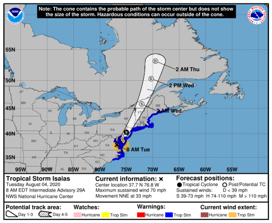
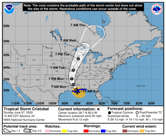
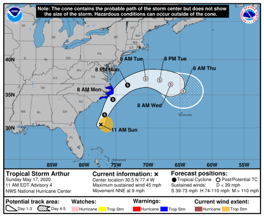
Tropical Storm Isaias Advisory Number 30
NWS National Hurricane Center Miami FL AL092020
1100 AM EDT Tue Aug 04 2020

…CENTER OF ISAIAS MOVING RAPIDLY ACROSS EASTERN MARYLAND…
…STRONG WINDS…HEAVY RAINFALL…AND TORNADOES WILL CONTINUE TO
SPREAD NORTH-NORTHEASTWARD ALONG THE MID-ATLANTIC COAST TODAY…
SUMMARY OF 1100 AM EDT…1500 UTC…INFORMATION
———————————————–
LOCATION…39.1N 76.1W
ABOUT 20 MI…30 KM SSW OF FREDERICK MARYLAND
ABOUT 70 MI…110 KM SW OF PHILADELPHIA PENNSYLVANIA
MAXIMUM SUSTAINED WINDS…70 MPH…110 KM/H
PRESENT MOVEMENT…NNE OR 20 DEGREES AT 35 MPH…56 KM/H
MINIMUM CENTRAL PRESSURE…993 MB…29.33 INCHES
WATCHES AND WARNINGS
——————–
CHANGES WITH THIS ADVISORY:

The Tropical Storm Warning has been discontinued south of Duck,
North Carolina, including the Pamlico and Albemarle Sounds.

The Storm Surge Warning has been discontinued.

SUMMARY OF WATCHES AND WARNINGS IN EFFECT:

A Tropical Storm Warning is in effect for…
* North of Duck North Carolina to Eastport Maine
* Chesapeake Bay
* Tidal Potomac River
* Delaware Bay
* Long Island and Long Island Sound
* Martha’s Vineyard, Nantucket, and Block Island

A Tropical Storm Warning means that tropical storm conditions are
expected somewhere within the warning area, in this case
within the next 12 to 18 hours.

For storm information specific to your area, including possible
inland watches and warnings, please monitor products issued by your
local National Weather Service forecast office.
DISCUSSION AND OUTLOOK
———————-
At 1100 AM EDT (1500 UTC), the center of Tropical Storm Isaias was
located by NOAA Doppler weather radars and surface observations
near latitude 39.1 North, longitude 76.1 West. Isaias is moving
toward the north-northeast near 35 mph (56 km/h), and this general
motion accompanied by some increase in forward speed is expected
through tonight. On the forecast track, the center of Isaias will
continue to move near or along the coast of the mid-Atlantic states
today, and move across the northeastern United States into southern
Canada tonight.

Data from Doppler weather radars along with surface observations
indicate that maximum sustained winds remain near 70 mph (110 km/h)
with higher gusts. Only gradual weakening is anticipated while
Isaias moves north-northeastward near the mid-Atlantic coast today.
A faster rate of weakening is expected to begin tonight, and the
system is forecast to become post-tropical tonight or early
Wednesday.

Tropical-storm-force winds extend outward up to 140 miles (220 km)
from the center. During the past hour, a sustained wind of 55 mph
(89 km/h) and a gust to 65 mph (105 km/h) were reported by a
Weatherflow site at Ocean City, Maryland. A sustained wind of 45
mph (72 km/h) and a gust to 57 mph (92 km/h) were reported at Ocean
City-South Beach, New Jersey.

The estimated minimum central pressure based on surface
observations is 993 mb (29.33 inches).
HAZARDS AFFECTING LAND
———————-
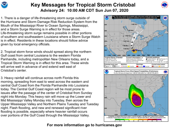
Key messages for Isaias can be found in the Tropical Cyclone
Discussion under AWIPS header MIATCDAT4, WMO header WTNT44 KNHC,
and on the web at http://www.hurricanes.gov/text/MIATCDAT4.shtml.

STORM SURGE: The combination of storm surge and the tide will
cause normally dry areas near the coast to be flooded by rising
waters moving inland from the shoreline. The water could reach the
following heights above ground somewhere in the indicated areas if
the peak surge occurs at the time of high tide…

Ocracoke Inlet NC to the North Carolina/Virginia border including
Pamlico Sound, Albemarle Sound, Pamlico and Neuse Rivers…1-2 ft

North of the North Carolina/Virginia border to Martha’s Vineyard
including the Chesapeake Bay, the Tidal Potomac River, Delaware Bay,
Long Island Sound, Block Island Sound, Narragansett Bay, Buzzards
Bay, and Vineyard Sound…1-3 ft

The deepest water will occur along the immediate coast in areas of
onshore winds, where the surge will be accompanied by large waves.
Surge-related flooding depends on the relative timing of the surge
and the tidal cycle, and can vary greatly over short distances.
For information specific to your area, please see products issued
by your local National Weather Service forecast office.

WIND: Widespread tropical-storm conditions are expected in the
tropical storm warning area in the mid-Atlantic states, including
portions of the Chesapeake Bay region today, with wind gusts to
hurricane force possible. These winds could cause significant tree
damage and power outages.

Tropical storm conditions are expected to reach southern New
England this afternoon and northern New England tonight.

Gale-force winds are expected to spread into southeastern Quebec
tonight and Wednesday. See products issued by Environment
Canada for more information.

RAINFALL: The following rainfall accumulations are expected along
and near the track of Isaias:

Central and Northern Mid-Atlantic: Additional 2 to 4 inches,
isolated maximum storm totals of 8 inches.

Eastern New York into Vermont: 2 to 4 inches, isolated maximum
totals 6 inches.

Western Connecticut, western Massachusetts, New Hampshire and
western Maine: 1 to 3 inches.

Heavy rainfall along the East Coast, near the path of Isaias, will
result in flash and urban flooding, some of which may be significant
in the mid-Atlantic and Northeast through tonight. Potentially
life-threatening urban flooding remains possible Philadelphia, and
elsewhere along and just west of the I-95 corridor today. Scattered
minor to moderate river flooding is likely across portions of the
Mid-Atlantic. Quick-responding rivers in the Northeast will also be
susceptible to minor river flooding.

TORNADOES: A few tornadoes are possible across northern New Jersey
and southeastern New York, through southern New England, by late
afternoon. A risk for tornadoes may continue across northern New
England through this evening.

SURF: Swells generated by Isaias will spread northward along the
mid-Atlantic and Northeast coasts of the United States today. These
swells are likely to cause life-threatening surf and rip current
conditions. Please consult products from your local weather office.
NEXT ADVISORY
————-
Next intermediate advisory at 200 PM EDT.
Next complete advisory at 500 PM EDT.

$$
Forecaster Stewart

NNNN

Local info on Isaias: Wilmington NC, Raleigh NC, Newport/Morehead City NC, Wakefield VA, Baltimore/Washington, Philadelphia PA, New York NY, Albany NY, Boston MA, Portland ME, Caribou ME

CANADA

Latest Radar Image (link)


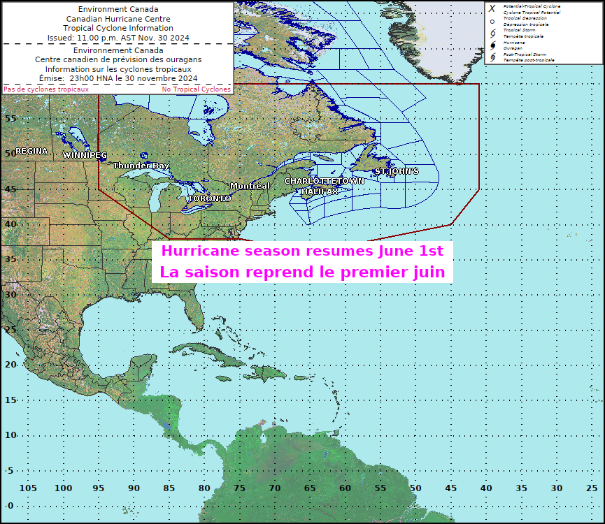
Tropical Cyclone Information Statements


8:36 AM ADT Tuesday 04 August 2020
Tropical cyclone information statement for:

New Brunswick

Québec – south:

  • Amqui – Matapédia Valley
  • Beauce
  • Charlevoix
  • Eastern Townships
  • Forillon National Park – Gaspé – Percé
  • Gaspésie National Park – Murdochville
  • Kamouraska – Rivière-du-Loup – Trois-Pistoles
  • Matane
  • Montmagny – L’Islet
  • New Carlisle – Chandler
  • Québec
  • Restigouche – Bonaventure
  • Rimouski – Mont-Joli
  • Sainte-Anne-des-Monts – Grande-Vallée
  • Témiscouata

For Tropical Storm Isaias.

The next information statement will be issued by 2:00 p.m. EDT today.

1. Summary of basic information at 8:00 a.m. EDT.

Location: 37.7 North 76.8 West.

About 54 kilometres east-northeast of Richmond, VA.

Maximum sustained winds: 100 kilometres per hour.

Present movement: north-northeast at 46 kilometres per hour.

Minimum central pressure: 994 millibars.

2. Public weather impacts and warnings summary.

The Canadian Hurricane Centre is closely monitoring the progress of Tropical Storm Isaias (pronounced ees-ah-EE-ahs). Isaias will approach Quebec and New Brunswick through New England tonight. The expected impacts for Canada are heavy rainfall in southern and eastern parts of Quebec and moderate gusty winds including New Brunswick.

a. Wind.

Southeasterly winds gusting to 50 km/h are likely over New Brunswick and parts of Quebec including eastern Townships and areas along the St. Lawrence River tonight. As the low moves northward through Quebec Wednesday expect warm and humid southerly winds across the region. New Brunswick and the Gaspe region could see gusts up to 70 km/h Wednesday afternoon.

b. Rainfall.

A brief period of heavy rain from the direct remnants of the storm is expected over parts of southern Quebec after midnight tonight into early tomorrow morning. The eastern Townships northward to the Quebec City area is most likely to be affected with up to 60 mm. Most of the rain will fall over a short period of time (2-3 hours) therefore some minor flooding may occur in prone locations.

Additional note on rainfall as of Tuesday morning: Showers well ahead and to the west of the storm track throughout today are not directly related to Isaias. Also note that heavy rainfall may occur further west into the Montreal area as well due to a combination of Isaias’ remnants and a non-tropical low farther west.

c. Surge/Waves.

Nothing significant expected. Waves of 2-3 m along the southwestern portion of New Brunswick are expected tonight and into Wednesday.

3. Marine weather impacts and warnings summary.

Marginal gale-force winds can be expected over westernmost Maritime marine regions including the mouth of the St. Lawrence River tonight and into Wednesday. Seas of 2-3 metres are expected. Small craft operators should take precautions.

Forecasters: Fogarty/Spencer/Hatt

Please continue to monitor alerts issued by the Canadian Hurricane Centre and forecasts issued by Environment Canada.

For more comprehensive information about track tables and forecast rationale, please see the Technical Discussion

Source: Canadian Hurricane Centre (link)


TROPICAL STORM RISK
University College London, UK

STORM ALERT NOT AVAILABLE AT THIS TIME

For graphical forecast information and further details please visit http://www.tropicalstormrisk.com/

Current probability of tropical storm winds

Current probability of Cat 1 or above winds

MARITIME/SHIPPING

WTNT24 KNHC 041441
TCMAT4

TROPICAL STORM ISAIAS FORECAST/ADVISORY NUMBER 30
NWS NATIONAL HURRICANE CENTER MIAMI FL AL092020
1500 UTC TUE AUG 04 2020

CHANGES IN WATCHES AND WARNINGS WITH THIS ADVISORY…

THE TROPICAL STORM WARNING HAS BEEN DISCONTINUED SOUTH OF
DUCK…NORTH CAROLINA…INCLUDING THE PAMLICO AND ALBEMARLE SOUNDS.

THE STORM SURGE WARNING HAS BEEN DISCONTINUED.

SUMMARY OF WATCHES AND WARNINGS IN EFFECT…

A TROPICAL STORM WARNING IS IN EFFECT FOR…
* NORTH OF DUCK NORTH CAROLINA TO EASTPORT MAINE
* CHESAPEAKE BAY
* TIDAL POTOMAC RIVER
* DELAWARE BAY
* LONG ISLAND AND LONG ISLAND SOUND
* MARTHA’S VINEYARD…NANTUCKET…AND BLOCK ISLAND

A TROPICAL STORM WARNING MEANS THAT TROPICAL STORM CONDITIONS ARE
EXPECTED SOMEWHERE WITHIN THE WARNING AREA…IN THIS CASE
WITHIN THE NEXT 12 TO 18 HOURS.

TROPICAL STORM CENTER LOCATED NEAR 39.1N 76.1W AT 04/1500Z
POSITION ACCURATE WITHIN 25 NM

PRESENT MOVEMENT TOWARD THE NORTH-NORTHEAST OR 20 DEGREES AT 30 KT

ESTIMATED MINIMUM CENTRAL PRESSURE 993 MB
MAX SUSTAINED WINDS 60 KT WITH GUSTS TO 80 KT.
50 KT……. 60NE 60SE 0SW 0NW.
34 KT…….110NE 120SE 40SW 40NW.
12 FT SEAS..180NE 180SE 0SW 0NW.
WINDS AND SEAS VARY GREATLY IN EACH QUADRANT. RADII IN NAUTICAL
MILES ARE THE LARGEST RADII EXPECTED ANYWHERE IN THAT QUADRANT.

REPEAT…CENTER LOCATED NEAR 39.1N 76.1W AT 04/1500Z
AT 04/1200Z CENTER WAS LOCATED NEAR 37.7N 76.8W

FORECAST VALID 05/0000Z 43.2N 73.8W…INLAND
MAX WIND 50 KT…GUSTS 65 KT.
50 KT… 40NE 70SE 20SW 0NW.
34 KT…120NE 180SE 40SW 40NW.

FORECAST VALID 05/1200Z 48.2N 71.7W…POST-TROP/INLAND
MAX WIND 35 KT…GUSTS 45 KT.
34 KT… 0NE 180SE 0SW 0NW.

FORECAST VALID 06/0000Z 52.0N 71.1W…POST-TROP/EXTRATROP
MAX WIND 30 KT…GUSTS 40 KT.

FORECAST VALID 06/1200Z 53.6N 69.5W…POST-TROP/EXTRATROP
MAX WIND 20 KT…GUSTS 30 KT.

FORECAST VALID 07/0000Z…DISSIPATED

REQUEST FOR 3 HOURLY SHIP REPORTS WITHIN 300 MILES OF 39.1N 76.1W

INTERMEDIATE PUBLIC ADVISORY…WTNT34 KNHC/MIATCPAT4…AT 04/1800Z

NEXT ADVISORY AT 04/2100Z

$$
FORECASTER STEWART

CANADA


=========================================================================

Do not use any information on this site for life or death decisions. All information is intended as supplementary to official sources. Kindly refer to your country’s official weather agency/government website for local warnings, advisories and bulletins.


Mexico/ US: Tropical Storm HANNA 26/1500Z 26.1N 99.7W, moving WSW ~8.09kt. Wind ~40.49kt. 995mb (NHC FL) – Updated 26 Jul 2020 1655Z (GMT/UTC)

Tropical Storm HANNA

…CENTER OF HANNA CONTINUES TO MOVE INLAND OVER NORTHEASTERN
MEXICO…
…HEAVY RAIN AND DANGEROUS FLASH FLOODING CONTINUES OVER FAR
SOUTHEAST TEXAS AND NORTHEAST MEXICO…

Mexico beware!

A Tropical Storm Warning is in effect for…
* Barra el Mezquital Mexico to the Mouth of the Rio Grande

Interests in northeastern Mexico should monitor the progress of
Hanna.

The center of Hanna should continue to move farther inland
over northeastern Mexico through tonight.

National Hurricane Center (FL)


145044_5day_cone_no_line_and_wind


704
WTNT33 KNHC 261444
TCPAT3

BULLETIN
Tropical Storm Hanna Advisory Number 15
NWS National Hurricane Center Miami FL AL082020
1000 AM CDT Sun Jul 26 2020

…CENTER OF HANNA CONTINUES TO MOVE INLAND OVER NORTHEASTERN
MEXICO…
…HEAVY RAIN AND DANGEROUS FLASH FLOODING CONTINUES OVER FAR
SOUTHEAST TEXAS AND NORTHEAST MEXICO…
SUMMARY OF 1000 AM CDT…1500 UTC…INFORMATION
———————————————–
LOCATION…26.1N 99.7W
ABOUT 75 MI…120 KM NE OF MONTERREY MEXICO
ABOUT 90 MI…150 KM W OF MCALLEN TEXAS
MAXIMUM SUSTAINED WINDS…45 MPH…75 KM/H
PRESENT MOVEMENT…WSW OR 250 DEGREES AT 9 MPH…15 KM/H
MINIMUM CENTRAL PRESSURE…995 MB…29.39 INCHES
WATCHES AND WARNINGS
——————–
CHANGES WITH THIS ADVISORY:

The Tropical Storm Warning along the coast of Texas south of Baffin
Bay has been discontinued.

SUMMARY OF WATCHES AND WARNINGS IN EFFECT:

A Tropical Storm Warning is in effect for…
* Barra el Mezquital Mexico to the Mouth of the Rio Grande

Interests in northeastern Mexico should monitor the progress of
Hanna.

For storm information specific to your area, please monitor
products issued by your national meteorological service.
DISCUSSION AND OUTLOOK
———————-
At 1000 AM CDT (1500 UTC), the center of Tropical Storm Hanna was
located near latitude 26.1 North, longitude 99.7 West. Hanna is
moving toward the west-southwest near 9 mph (15 km/h) and this
motion is expected to continue through Monday. On the forecast
track, the center of Hanna should continue to move farther inland
over northeastern Mexico through tonight.

Maximum sustained winds have decreased to near 45 mph (75 km/h)
with higher gusts. Additional weakening is expected as the
center of Hanna moves farther inland, and the cyclone is expected
to weaken to a tropical depression later today and dissipate Monday
or Monday night.

Tropical-storm-force winds extend outward up to 105 miles (165 km)
from the center.

The estimated minimum central pressure is 995 mb (29.39 inches).
HAZARDS AFFECTING LAND
———————-
Key messages for Hanna can be found in the Tropical Cyclone
Discussion under AWIPS header MIATCDAT3, WMO header WTNT43 KNHC and
on the web at http://www.hurricanes.gov/text/MIATCDAT3.shtml.

STORM SURGE: Water levels along the Texas coast will gradually
subside through this afternoon. Consult products issued by your
local National Weather Service forecast office for additional
information.

WIND: Tropical storm conditions will continue near the center of
Hanna for the next several hours, and along the coast of Mexico
within the warning area for a few more hours.

RAINFALL: Hanna is expected to produce the following rain
accumulations and flood threats through Monday:

South Texas…Additional 2 to 5 inches. Storm total amounts 6 to 12
inches, isolated 16 inches.
Northern Mexican states of Coahuila, Nuevo Leon, Tamaulipas…6 to
12 inches, isolated 16 inches.
Northern Mexican states of northern Zacatecas and eastern
Durango…1 to 4 inches.

This rain will produce life-threatening flash flooding, rapid rises
on small streams, and isolated minor to moderate river flooding in
South Texas. Flash flooding and mudslides are likely across Northern
Mexican states.

SURF: Swells generated by Hanna will continue to affect much
of the Texas and Louisiana coasts for another day or so. These
swells are likely to cause life-threatening surf and rip current
conditions. Please consult products from your local weather
office.

TORNADOES: A few tornadoes are possible today into this evening
across parts of south Texas.
NEXT ADVISORY
————-
Next intermediate advisory at 100 PM CDT.
Next complete advisory at 400 PM CDT.

$$
Forecaster Brown


Local information on Hanna: Houston/Galveston TX, Corpus Cristi TX, Brownsville TX

MEXICO

See https://smn.conagua.gob.mx/files/pdfs/comunicados-de-prensa/Comunicado588-20.pdf

https://smn.conagua.gob.mx/es/


TROPICAL STORM RISK
University College London, UK

N Atlantic: Storm Alert issued at 26 Jul, 2020 15:00 GMT

Tropical Storm HANNA is currently located near 26.1 N 99.7 W with maximum 1-min sustained winds of 40kts (46 mph). HANNA is forecast to affect land to the following likelihood(s) at the given lead time(s):
Yellow Alert Country(s) or Province(s)
    Mexico
        probability for TS is 95% currently
    the United States
        probability for TS is 90% currently
Yellow Alert City(s) and Town(s)
    Monterrey (25.7 N, 100.3 W)
        probability for TS is 55% currently

Green Alert City(s) and Town(s)
    San Fernando (24.9 N, 98.2 W)
        probability for TS is 35% currently

Note that
Yellow Alert (Elevated) is CAT 1 or above to between 10% and 30% probability, or TS to above 50% probability.
Green Alert (Low) is TS to between 31% and 50% probability.
CAT 1 means Hurricane strength winds of at least 74 mph, 119 km/h or 64 knots 1-min sustained.
TS means Tropical Storm strength winds of at least 39 mph, 63 km/h or 34 knots 1-min sustained.

For graphical forecast information and further details please visit http://www.tropicalstormrisk.com/


Current probability of tropical storm winds


MARITIME/SHIPPING

WTNT23 KNHC 261444
TCMAT3

TROPICAL STORM HANNA FORECAST/ADVISORY NUMBER 15
NWS NATIONAL HURRICANE CENTER MIAMI FL AL082020
1500 UTC SUN JUL 26 2020

CHANGES IN WATCHES AND WARNINGS WITH THIS ADVISORY…

THE TROPICAL STORM WARNING ALONG THE COAST OF TEXAS SOUTH OF BAFFIN
BAY HAS BEEN DISCONTINUED.

SUMMARY OF WATCHES AND WARNINGS IN EFFECT…

A TROPICAL STORM WARNING IS IN EFFECT FOR…
* BARRA EL MEZQUITAL MEXICO TO THE MOUTH OF THE RIO GRANDE

INTERESTS IN NORTHEASTERN MEXICO SHOULD MONITOR THE PROGRESS OF
HANNA.

TROPICAL STORM CENTER LOCATED NEAR 26.1N 99.7W AT 26/1500Z
POSITION ACCURATE WITHIN 40 NM

PRESENT MOVEMENT TOWARD THE WEST-SOUTHWEST OR 250 DEGREES AT 8 KT

ESTIMATED MINIMUM CENTRAL PRESSURE 995 MB
MAX SUSTAINED WINDS 40 KT WITH GUSTS TO 50 KT.
34 KT……. 60NE 90SE 30SW 30NW.
WINDS AND SEAS VARY GREATLY IN EACH QUADRANT. RADII IN NAUTICAL
MILES ARE THE LARGEST RADII EXPECTED ANYWHERE IN THAT QUADRANT.

REPEAT…CENTER LOCATED NEAR 26.1N 99.7W AT 26/1500Z
AT 26/1200Z CENTER WAS LOCATED NEAR 26.2N 99.2W

FORECAST VALID 27/0000Z 25.5N 100.6W…INLAND
MAX WIND 30 KT…GUSTS 40 KT.

FORECAST VALID 27/1200Z 25.0N 101.9W…INLAND
MAX WIND 25 KT…GUSTS 35 KT.

FORECAST VALID 28/0000Z 24.9N 102.9W…POST-TROP/INLAND
MAX WIND 20 KT…GUSTS 30 KT.

FORECAST VALID 28/1200Z…DISSIPATED

REQUEST FOR 3 HOURLY SHIP REPORTS WITHIN 300 MILES OF 26.1N 99.7W

INTERMEDIATE PUBLIC ADVISORY…WTNT33 KNHC/MIATCPAT3…AT 26/1800Z

NEXT ADVISORY AT 26/2100Z

$$
FORECASTER BROWN

=========================================================================

Do not use any information on this site for life or death decisions. All information is intended as supplementary to official sources. Kindly refer to your country’s official weather agency/government website for local warnings, advisories and bulletins.


Hawaii/ Central Pacific: Hurricane DOUGLAS CAT1 26/1500Z 20.7N 154.3W, moving WNW ~14.03kt. Wind ~80.99kt. 983mb (CPHC FL) – Updated 26 Jul 2020 1530Z (GMT/UTC)

HURRICANE DOUGLAS (08E)

………DANGEROUS HURRICANE DOUGLAS CLOSING IN ON THE HAWAIIAN ISLANDS……HURRICANE WARNING ISSUED FOR MAUI COUNTY……NHC FL

DOUGLAS is a category 1 storm on the Saffir Simpson Hurricane Wind Scale (TSR UCL London data)

A Hurricane Warning is in effect for…
* Maui County, including the islands of Maui, Lanai, Molokai and
Kahoolawe
* Oahu
* Kauai County, including the islands of Kauai and Niihau
A Tropical Storm Warning is in effect for…
* Hawaii County

Interests elsewhere in the Papahanaumokuakea Marine National
Monument should monitor the progress of this system.

Douglas will pass near, or over, the islands from
Maui to Kauai today and tonight.

Hawaii /Hawaiian Islands beware

Central Pacific Hurricane Center (FL)

144537_5day_cone_no_line_and_wind


000
WTPA32 PHFO 261439
TCPCP2

BULLETIN
Hurricane Douglas Advisory Number 25
NWS Central Pacific Hurricane Center Honolulu HI EP082020
500 AM HST Sun Jul 26 2020

…DANGEROUS HURRICANE DOUGLAS CLOSING IN ON THE HAWAIIAN ISLANDS…
…HURRICANE WARNING ISSUED FOR MAUI COUNTY…
SUMMARY OF 500 AM HST…1500 UTC…INFORMATION
———————————————-
LOCATION…20.7N 154.3W
ABOUT 145 MI…230 KM E OF KAHULUI HAWAII
ABOUT 235 MI…380 KM E OF HONOLULU HAWAII
MAXIMUM SUSTAINED WINDS…90 MPH…150 KM/H
PRESENT MOVEMENT…WNW OR 285 DEGREES AT 16 MPH…26 KM/H
MINIMUM CENTRAL PRESSURE…983 MB…29.03 INCHES
WATCHES AND WARNINGS
——————–
CHANGES WITH THIS ADVISORY…

The Hurricane Watch for Maui County, including the islands of Maui,
Lanai, Molokai and Kahoolawe has been upgraded to a Hurricane
Warning.

The Hurricane Watch has been canceled for Hawaii County.

A Tropical Storm Watch has been issued for portions of the
Papahanaumokuakea Marine National Monument from French Frigate
Shoals to Maro Reef.

SUMMARY OF WATCHES AND WARNINGS IN EFFECT…

A Hurricane Warning is in effect for…
* Maui County, including the islands of Maui, Lanai, Molokai and
Kahoolawe
* Oahu
* Kauai County, including the islands of Kauai and Niihau

A Tropical Storm Warning is in effect for…
* Hawaii County

A Tropical Storm Watch is in effect for…
* Portions of the Papahanaumokuakea Marine National Monument from
Nihoa to French Frigate Shoals to Maro Reef.

A Hurricane Warning means that hurricane conditions are expected
somewhere within the warning area, in this case within the next
24 hours.

A Tropical Storm Warning means that tropical storm conditions are
expected somewhere within the warning area, in this case within the
next 12 hours.

A Tropical Storm Watch means that tropical storm conditions are
possible within the watch area, in this case within the next 36 to
48 hours.

Interests elsewhere in the Papahanaumokuakea Marine National
Monument should monitor the progress of this system.

For storm information specific to your area, please monitor
products issued by the National Weather Service office in
Honolulu Hawaii.
DISCUSSION AND OUTLOOK
———————-
At 500 AM HST (1500 UTC), the center of Hurricane Douglas was
located near latitude 20.7 North, longitude 154.3 West. Douglas is
moving toward the west-northwest near 16 mph (26 km/h) and this
motion is expected to continue over the next couple of days. On the
forecast track, Douglas will pass near, or over, the islands from
Maui to Kauai today and tonight.

Maximum sustained winds are near 90 mph (150 km/h) with higher
gusts. Gradual weakening is forecast during the next 48 hours, but
Douglas is expected to remain a hurricane as it moves through the
islands.

Hurricane-force winds extend outward up to 30 miles (45 km) from the
center and tropical-storm-force winds extend outward up to 105 miles
(165 km).

The estimated minimum central pressure is 983 mb (29.03 inches).
HAZARDS AFFECTING LAND
———————-
WIND: Hurricane conditions are expected in portions of Maui County
today, on Oahu by this afternoon, and on Kauai and Niihau tonight.
Tropical Storm conditions are imminent across the Big Island.
Due to the steep terrain of the islands, hurricane-force wind
gusts are possible even within the tropical storm warning area.

SURF: Large swells generated by Douglas will affect the Hawaiian
Islands into Monday, producing life-threatening and potentially
destructive surf along exposed shores.

STORM SURGE: The combination of higher than predicted water
levels, dangerous storm surge, and large breaking waves will raise
water levels by as much as 3 feet above normal tides near the center
of Douglas.

RAINFALL: Heavy rainfall associated with Douglas is expected to
affect portions of the main Hawaiian Islands from early this
morning into Monday. Total rain accumulations of 5 to 10 inches are
possible from Maui County westward to Kauai County, with the
greatest amounts up to 15 inches in elevated terrain. This rain may
result in life-threatening flash flooding and land slides, as well
as rapid water level rises on small streams. Douglas could produce
an additional 2 to 4 inches of rainfall over the northern half of
the Big Island.

Key messages for Douglas can be found in the Tropical Cyclone
Discussion under AWIPS header HFOTCDCP2 and WMO header WTPA32 PHFO.
NEXT ADVISORY
————-
Next intermediate advisory at 800 AM HST.
Next complete advisory at 1100 AM HST.

$$
Forecaster Birchard


TROPICAL STORM RISK
University College London, UK

NE Pacific: Storm Alert issued at 25 Jul, 2020 9:00 GMT

NE Pacific: Storm Alert issued at 26 Jul, 2020 15:00 GMT

Hurricane DOUGLAS is currently located near 20.7 N 154.3 W with maximum 1-min sustained winds of 80 kts (92 mph). DOUGLAS is a category 1 storm on the Saffir Simpson Hurricane Wind Scale. DOUGLAS is forecast to affect land to the following likelihood(s) at the given lead time(s):

Red Alert City(s) and Town(s)
    Honolulu (21.3 N, 157.8 W)
        probability for CAT 1 or above is 40% in about 21 hours
        probability for TS is 60% within 9 hours

Yellow Alert City(s) and Town(s)
    Hilo (19.7 N, 155.1 W)
        probability for TS is 60% within 9 hours

Note that
Red Alert (Severe) is CAT 1 or above to between 31% and 100% probability.
Yellow Alert (Elevated) is CAT 1 or above to between 10% and 30% probability, or TS to above 50% probability.
CAT 1 means Hurricane strength winds of at least 74 mph, 119 km/h or 64 knots 1-min sustained.
TS means Tropical Storm strength winds of at least 39 mph, 63 km/h or 34 knots 1-min sustained.


For graphical forecast information and further details please visit http://www.tropicalstormrisk.com/


Current probability of tropical storm wind


Current probability of Cat 1 or above winds


MARITIME/SHIPPING

WTPA22 PHFO 261434
TCMCP2

HURRICANE DOUGLAS FORECAST/ADVISORY NUMBER 25
NWS CENTRAL PACIFIC HURRICANE CENTER HONOLULU HI EP082020
1500 UTC SUN JUL 26 2020

CHANGES IN WATCHES AND WARNINGS WITH THIS ADVISORY…

THE HURRICANE WATCH FOR MAUI COUNTY…INCLUDING THE ISLANDS OF
MAUI…LANAI…MOLOKAI AND KAHOOLAWE HAS BEEN UPGRADED TO A
HURRICANE WARNING.

THE HURRICANE WATCH HAS BEEN CANCELED FOR HAWAII COUNTY.

A TROPICAL STORM WATCH HAS BEEN ISSUED FOR PORTIONS OF THE
PAPAHANAUMOKUAKEA MARINE NATIONAL MONUMENT FROM FRENCH FRIGATE
SHOALS TO MARO REEF.

SUMMARY OF WATCHES AND WARNINGS IN EFFECT…

A HURRICANE WARNING IS IN EFFECT FOR…
* MAUI COUNTY…INCLUDING THE ISLANDS OF MAUI…LANAI…MOLOKAI AND
KAHOOLAWE
* OAHU
* KAUAI COUNTY…INCLUDING THE ISLANDS OF KAUAI AND NIIHAU

A TROPICAL STORM WARNING IS IN EFFECT FOR…
* HAWAII COUNTY

A TROPICAL STORM WATCH IS IN EFFECT FOR…
* PORTIONS OF THE PAPAHANAUMOKUAKEA MARINE NATIONAL MONUMENT FROM
NIHOA TO FRENCH FRIGATE SHOALS TO MARO REEF.

A HURRICANE WARNING MEANS THAT HURRICANE CONDITIONS ARE EXPECTED
SOMEWHERE WITHIN THE WARNING AREA…IN THIS CASE WITHIN THE NEXT
36 HOURS.

A TROPICAL STORM WARNING MEANS THAT TROPICAL STORM CONDITIONS ARE
EXPECTED SOMEWHERE WITHIN THE WARNING AREA…IN THIS CASE WITHIN THE
NEXT 12 HOURS.

A TROPICAL STORM WATCH MEANS THAT TROPICAL STORM CONDITIONS ARE
POSSIBLE WITHIN THE WATCH AREA…IN THIS CASE WITHIN THE NEXT 36 TO
48 HOURS.

INTERESTS ELSEWHERE IN THE PAPAHANAUMOKUAKEA MARINE NATIONAL
MONUMENT SHOULD MONITOR THE PROGRESS OF THIS SYSTEM.

HURRICANE CENTER LOCATED NEAR 20.7N 154.3W AT 26/1500Z
POSITION ACCURATE WITHIN 10 NM

PRESENT MOVEMENT TOWARD THE WEST-NORTHWEST OR 285 DEGREES AT 14 KT

ESTIMATED MINIMUM CENTRAL PRESSURE 983 MB
MAX SUSTAINED WINDS 80 KT WITH GUSTS TO 100 KT.
64 KT……. 25NE 15SE 10SW 25NW.
50 KT……. 40NE 35SE 20SW 40NW.
34 KT……. 90NE 60SE 40SW 90NW.
12 FT SEAS..240NE 150SE 150SW 240NW.
WINDS AND SEAS VARY GREATLY IN EACH QUADRANT. RADII IN NAUTICAL
MILES ARE THE LARGEST RADII EXPECTED ANYWHERE IN THAT QUADRANT.

REPEAT…CENTER LOCATED NEAR 20.7N 154.3W AT 26/1500Z
AT 26/1200Z CENTER WAS LOCATED NEAR 20.5N 153.6W

FORECAST VALID 27/0000Z 21.4N 156.6W
MAX WIND 75 KT…GUSTS 90 KT.
64 KT… 20NE 10SE 10SW 20NW.
50 KT… 40NE 30SE 20SW 40NW.
34 KT… 90NE 60SE 40SW 90NW.

FORECAST VALID 27/1200Z 22.3N 159.5W
MAX WIND 70 KT…GUSTS 85 KT.
64 KT… 10NE 0SE 0SW 10NW.
50 KT… 30NE 20SE 10SW 30NW.
34 KT… 80NE 50SE 30SW 80NW.

FORECAST VALID 28/0000Z 22.8N 162.7W
MAX WIND 60 KT…GUSTS 75 KT.
50 KT… 20NE 10SE 10SW 20NW.
34 KT… 80NE 40SE 30SW 80NW.

FORECAST VALID 28/1200Z 23.3N 166.1W
MAX WIND 55 KT…GUSTS 65 KT.
50 KT… 20NE 10SE 5SW 20NW.
34 KT… 80NE 20SE 10SW 80NW.

FORECAST VALID 29/0000Z 23.7N 169.5W
MAX WIND 50 KT…GUSTS 60 KT.
50 KT… 10NE 0SE 0SW 10NW.
34 KT… 70NE 20SE 10SW 70NW.

FORECAST VALID 29/1200Z 24.0N 173.0W
MAX WIND 45 KT…GUSTS 55 KT.
34 KT… 70NE 20SE 10SW 70NW.

EXTENDED OUTLOOK. NOTE…ERRORS FOR TRACK HAVE AVERAGED NEAR 150 NM
ON DAY 4 AND 200 NM ON DAY 5…AND FOR INTENSITY NEAR 20 KT EACH DAY

OUTLOOK VALID 30/1200Z 24.5N 179.5E
MAX WIND 35 KT…GUSTS 45 KT.

OUTLOOK VALID 31/1200Z 25.5N 172.0E
MAX WIND 30 KT…GUSTS 40 KT.

REQUEST FOR 3 HOURLY SHIP REPORTS WITHIN 300 MILES OF 20.7N 154.3W

INTERMEDIATE PUBLIC ADVISORY…WTNT32 PHFO/HFOTCPCP2…AT 26/1800Z

NEXT ADVISORY AT 26/2100Z

$$
FORECASTER BIRCHARD

=========================================================================

Do not use any information on this site for life or death decisions. All information is intended as supplementary to official sources. Kindly refer to your country’s official weather agency/government website for local warnings, advisories and bulletins.


Philippines/ China/ South China Sea: Tropical Storm NURI 02W 12/1200Z 16.8N 117.2E, moving W 11kt. Max wind 35kt. 998hPa (RSMC Tokyo) – Published 12 Jun 2020 1425Z (GMT/UTC)

Tropical Storm NURI 02W

“BUTCHOY” SLIGHTLY INTENSIFIES AS IT MOVES WEST-NORTHWESTWARD AWAY FROM LUZON (PAGASA)

The tropical cyclone now over the central part of the South China Sea is expected to intensify gradually, and will edge closer to the coast of western Guangdong in the next couple of days. (HKO)

logo

2002-00


TS 2002 (Nuri)
Issued at 13:05 UTC, 12 June 2020

<Analysis at 12 UTC, 12 June>
Scale
Intensity
Center position N16°50′ (16.8°)
E117°10′ (117.2°)
Direction and speed of movement W 20 km/h (11 kt)
Central pressure 998 hPa
Maximum wind speed near center 18 m/s (35 kt)
Maximum wind gust speed 25 m/s (50 kt)
≥ 30 kt wind area ALL 220 km (120 NM)
<Forecast for 00 UTC, 13 June>
Intensity
Center position of probability circle N18°25′ (18.4°)
E115°25′ (115.4°)
Direction and speed of movement NW 20 km/h (12 kt)
Central pressure 996 hPa
Maximum wind speed near center 20 m/s (40 kt)
Maximum wind gust speed 30 m/s (60 kt)
Radius of probability circle 65 km (35 NM)
<Forecast for 12 UTC, 13 June>
Intensity
Center position of probability circle N20°00′ (20.0°)
E113°35′ (113.6°)
Direction and speed of movement NW 20 km/h (12 kt)
Central pressure 992 hPa
Maximum wind speed near center 23 m/s (45 kt)
Maximum wind gust speed 35 m/s (65 kt)
Radius of probability circle 95 km (50 NM)
<Forecast for 12 UTC, 14 June>
Intensity
TD
Center position of probability circle N23°30′ (23.5°)
E110°20′ (110.3°)
Direction and speed of movement NW 20 km/h (12 kt)
Central pressure 1002 hPa
Radius of probability circle 165 km (90 NM)


CMA LOGO

eng_nmc_tcbu_sfer_eme_acwp_l89_0w00010000_20200612170000007


Typhoon Message
20200612 20:56

National Meteorological Center No.1872
Analysis Time: Jun. 12th 12 UTC
Name of TC: NURI
Num. of TC: 2002
Current Location: 17.1°N 117.2°E
Max. 10-min Wind Speed: 18m/s(64.8km/h)
Central Pressure: 998hPa
Radius of 34knots Winds: NE 180km SE 150km SW 140km NW 120km
Forecast movement: next 24hrs NURI will moving NW at speed of 17km/h

xxxxx

Philippines

Tropical Depression”Butchoy”

Tropical Cyclone: ALERT

Issued at 11:00 am, 12 June 2020
(Valid for broadcast until the next advisory to be issued at 11:00 PM today or earlier.)
“BUTCHOY” SLIGHTLY INTENSIFIES AS IT MOVES WEST-NORTHWESTWARD AWAY FROM LUZON.
  • Tropical Depression BUTCHOY is forecast to intensify into a tropical storm within 24 hours. It is also expected to exit the Philippine Area of Responsibility (PAR) tonight or tomorrow morning and is forecast to move generally northwestward towards southern China.
  • All tropical cyclone wind signals have been lifted. However, occasional gusts associated with the Southwest Monsoon may still be experienced over most of Northern and Central Luzon and the western section of Southern Luzon and Visayas.
  • Heavy Rainfall Outlook
  • Today: Moderate to heavy rains over Zambales, Bataan, Pangasinan, the northern portion of Palawan including Calamian and Cuyo Islands, and Occidental Mindoro. Light to moderate with at times heavy monsoon rains over Metro Manila, Western Visayas, and the rest of Luzon.
  • Flooding and rain-induced landslides may occur during heavy or prolonged rainfall especially in areas that are highly or very highly susceptible to these hazards. The public and disaster risk reduction and management offices are advised to take appropriate measures and monitor the Rainfall or Thunderstorm Advisories or Heavy Rainfall Warnings of PAGASA Regional Services Divisions.
  • Coastal Water Conditions
  • In the next 24 hours, moderate to very rough seas (1.5 to 4.5 m) will be experienced over the seaboards of Northern and Central Luzon especially over the seaboards of Ilocos Region, Zambales and Bataan due to BUTCHOY and the Southwest Monsoon. Sea travel is risky especially for those using small seacrafts.
Location of Eye/center

At 10:00 AM today, the center of Tropical Depression “BUTCHOY” was estimated based on all available data at 140 km West Northwest of Iba, Zambales or 165 km West of Dagupan City, Pangasinan (15.9 °N, 118.8 °E )

Movement

Moving West Northwestward at 25 km/h

Strength

Maximum sustained winds of 55 km/h near the center and gustiness of up to 70 km/h

Forecast Position
  • 24 Hour(Tomorrow morning): 390 km West of Sinait, Ilocos Sur (OUTSIDE PAR)(17.4°N, 116.7°E)
  • 48 Hour(Sunday morning):915 km West of Extreme Northern Luzon (OUTSIDE PAR)(20.9°N, 113.2°E)
Wind Signal
No Tropical Cyclone Wind Signal
The public and the disaster risk reduction and management council concerned are advised to take appropriate actions and watch for the next update to be incorporated in the 4 PM Public Weather Forecast and in the next Severe Weather Bulletin to be issued at 11 PM today.


TROPICAL STORM RISK
University College London, UK

For graphical forecast information and further details please visit http://www.tropicalstormrisk.com/


Current probability of tropical storm winds


MARITIME/SHIPPING

WTJP21 RJTD 121200
WARNING 121200.
WARNING VALID 131200.
WARNING IS UPDATED EVERY 6 HOURS.
GALE WARNING.
TROPICAL STORM 2002 NURI (2002) UPGRADED FROM TROPICAL DEPRESSION 998
HPA
AT 16.8N 117.2E SOUTH CHINA SEA MOVING WEST 11 KNOTS.
POSITION POOR.
MAX WINDS 35 KNOTS NEAR CENTER.
RADIUS OF OVER 30 KNOT WINDS 120 MILES.
FORECAST POSITION FOR 130000UTC AT 18.4N 115.4E WITH 35 MILES RADIUS
OF 70 PERCENT PROBABILITY CIRCLE.
996 HPA, MAX WINDS 40 KNOTS NEAR CENTER.
FORECAST POSITION FOR 131200UTC AT 20.0N 113.6E WITH 50 MILES RADIUS
OF 70 PERCENT PROBABILITY CIRCLE.
992 HPA, MAX WINDS 45 KNOTS NEAR CENTER.
EXTENDED OUTLOOK.
FORECAST POSITION FOR 141200UTC AT 23.5N 110.3E WITH 90 MILES RADIUS
OF 70 PERCENT PROBABILITY CIRCLE.
1002 HPA.
BECOMING TROPICAL DEPRESSION.

JAPAN METEOROLOGICAL AGENCY.=

CHINA

海事天气公报
制作:赵伟   2020 年  06 月  12 日  18 时

MESSAGE FOR NAVAREA XI(IOR) ISSUED BY NMC BEIJING

AT 1015UTC JUN.12 2020=

MESSAGE IS UPDATED EVERY 06 HOURS=

SYNOPSIS VALID 0600UTC JUN.12=

FCST VALID 0600UTC JUN.13=

WARNNING=

NIL=

SUMMARY=

TD(01) 1000HPA AT 16.5N 118.3E MVG WNW 17KMH

AND MAX WINDS 15M/S NEAR CENTER(SEAS UP TO 4.0M)

AND FCST FOR 130600UTC AT 18.9N 115.0E 990HPA

AND MAX WINDS 23M/S NEAR CENTER=

SW WINDS FROM 12 TO 14M/S GUSTS 16M/S SEAS UP TO

3.0M OVER SEA SOUTH OF JAPAN=

SE WINDS FROM 12 TO 16M/S GUSTS 18M/S SEAS UP TO

2.5M OVER BASHI CHANNEL AND SEA EAST OF THE

PHILIPPINES

AND NORTHEASTERN PART OF SOUTH CHINA SEA=

DENSE FOG OBSERVED LOCALLY OVER BOHAI STRAIT AND

NORTHERN AND CENTRAL PARTS OF YELLOW SEA AND

SOUTHWESTERN PART OF JAPAN SEA AND HORIZONTAL

VISIBILITY LESS THAN 1KM=

HORIZONTAL VISIBILITY LESS THAN 10KM ALSO OVER

NORTHERN PART OF EAST CHINA SEA AND KOREA STRAIT

AND SEA SOUTH OF JAPAN AND EAST CENTRAL SOUTH

CHINA SEA AND ANDAMAN SEA AND LAUT MALUKU=

FCST=

BOHAI SEA

S WINDS 04 TO 07M/S SEA STATE SLT TO SMOOTH FOG

VIS POOR TO MOD=

BOHAI STRAIT

S WINDS BACK E 04 TO 07M/S SEA STATE SMOOTH HVY

FOG VIS VERY POOR=

NORTHERN PART OF YELLOW SEA

S WINDS BACK E 04 TO 07M/S SEA STATE SMOOTH HVY

FOG VIS VERY POOR=

CENTRAL PART OF YELLOW SEA

E WINDS 04 TO 07M/S INCR 07 TO 10M/S GUSTS 08 TO

12M/S SEA STATE SLT FOG BECMG HVY FOG VIS VERY

POOR=

SOUTHERN PART OF YELLOW SEA

E WINDS VEER SW 07 TO 10M/S SEA STATE SLT TO MOD

MOD RAIN BECMG HVY RAIN VIS VERY POOR=

NORTHERN PART OF EAST CHINA SEA

S WINDS 07 TO 10M/S GUSTS 08 TO 12M/S VEER SW

WINDS 08 TO 12M/S GUSTS 12 TO 15M/S SEA STATE MOD

OVERCAST BECMG CLOUDY VIS POOR TO GOOD=

SOUTHERN PART OF EAST CHINA SEA

S WINDS 08 TO 12M/S GUSTS 12 TO 15M/S SEA STATE

MOD OVERCAST VIS GOOD=

TAIWAN STRAIT

SE WINDS 08 TO 12M/S GUSTS 12 TO 15M/S SEA STATE

MOD OVERCAST VIS GOOD TO MOD=

SEA EAST OF TAIWAN

S WINDS 07 TO 10M/S GUSTS 08 TO 12M/S INCR 08 TO

12M/S GUSTS 12 TO 15M/S SEA STATE MOD OVERCAST

VIS POOR=

BASHI CHANNEL

SE WINDS 12 TO 15M/S GUSTS 14 TO 18M/S SEA STATE

ROUGH OVERCAST VIS POOR TO MOD=

NORTHEASTERN PART OF SOUTH CHINA SEA

E WINDS 12 TO 15M/S GUSTS 14 TO 18M/S BECMG

CYCLONIC WINDS 14 TO 18M/S GUSTS 18 TO 24M/S SEA

STATE ROUGH TO VERY ROUGH OVERCAST VIS POOR TO

VERY=

EAST CENTRAL SOUTH CHINA SEA

CYCLONIC WINDS 14 TO 18M/S GUSTS 18 TO 24M/S SEA

STATE ROUGH HVY RAIN VIS VERY POOR=

SOUTHWESTERN PART OF SOUTH CHINA SEA

SW WINDS 07 TO 10M/S SEA STATE MOD CLOUDY BECMG

LIGHT RAIN VIS POOR=

SOUTHEASTERN PART OF SOUTH CHINA SEA

SW WINDS 07 TO 10M/S SEA STATE MOD CLOUDY BECMG

LIGHT RAIN VIS POOR=

NORTHEASTERN PART OF JAPAN SEA

W WINDS BACK SW 07 TO 10M/S SEA STATE SLT HVY FOG

VIS MOD TO POOR=

SOUTHWESTERN PART OF JAPAN SEA

S WINDS VEER SW 04 TO 07M/S SEA STATE SLT HVY FOG

VIS POOR TO VERY=

KOREA STRAIT

SW WINDS 07 TO 10M/S GUSTS 08 TO 12M/S INCR 08 TO

12M/S GUSTS 12 TO 15M/S SEA STATE SLT TO MOD FOG

BECMG RAINSTORM VIS VERY POOR=

SEA SOUTH OF JAPAN

SW WINDS 12 TO 15M/S GUSTS 14 TO 18M/S DECR 08 TO

12M/S GUSTS 12 TO 15M/S SEA STATE MOD LIGHT RAIN

BECMG OVERCAST VIS VERY POOR TO POOR=

SEA NORTHEAST OF THE PHILIPPINES

SE WINDS 08 TO 12M/S GUSTS 12 TO 15M/S DECR 07 TO

10M/S GUSTS 08 TO 12M/S SEA STATE MOD OVERCAST

VIS POOR TO MOD=

SEA SOUTHEAST OF THE PHILIPPINES

E WINDS 04 TO 07M/S INCR 07 TO 10M/S GUSTS 08 TO

12M/S SEA STATE MOD CLOUDY VIS POOR TO MOD=

SEA WEST OF GUAM

E WINDS 07 TO 10M/S SEA STATE MOD LIGHT RAIN VIS

POOR=

SEA SOUTHWEST OF THE PHILIPPINES

SE WINDS 04 TO 07M/S SEA STATE SLT CLOUDY VIS MOD

TO POOR=

SEA NORTHEAST OF INDONESIA

E WINDS 04 TO 07M/S SEA STATE SLT TO MOD LIGHT

RAIN VIS POOR=

SEA SOUTHEAST OF INDONESIA

SE WINDS 07 TO 10M/S SEA STATE MOD LIGHT RAIN VIS

POOR=

SEA SOUTH OF JAWA

SE WINDS 07 TO 10M/S SEA STATE MOD CLOUDY VIS MOD=

SEA WEST OF SUMATERA

SE WINDS 07 TO 10M/S GUSTS 08 TO 12M/S INCR 08 TO

12M/S GUSTS 12 TO 15M/S SEA STATE MOD TO ROUGH

CLOUDY VIS POOR TO MOD=

MALACCA STRAIT

SE WINDS VEER S 04 TO 07M/S SEA STATE SLT CLOUDY

VIS POOR TO MOD=

SEA EAST OF SINGAPORE

SW WINDS 04 TO 07M/S BACK S WINDS 07 TO 10M/S SEA

STATE SMOOTH TO SLT LIGHT RAIN BECMG CLOUDY VIS

POOR=

SEA SOUTH OF VIETNAM

W WINDS BACK SW 07 TO 10M/S SEA STATE SLT LIGHT

RAIN VIS POOR=

GULF OF THAILAND

W WINDS 04 TO 07M/S INCR 07 TO 10M/S GUSTS 08 TO

12M/S SEA STATE SLT CLOUDY BECMG LIGHT RAIN VIS

POOR=

ANDAMAN SEA

SW WINDS VEER W 04 TO 07M/S SEA STATE MOD CLOUDY

BECMG LIGHT RAIN VIS POOR=

海事公报(北京,中央气象台)

2020年06月12日1015时(世界时)

06月12日0600时(世界时)海事分析

06月13日0600时(世界时)海事预报

海事分析

热带低压(01)位于北纬16.5度、东经118.3度,中心气压1000百帕,中心附近最大风速15米/秒,浪高4.0米,以17公里/小时的速度向西西北方向移动。

预计13日0600时(世界时)位于北纬18.9度、东经115.0度,中心气压990百帕,中心附近最大风速23米/秒。

日本以南洋面出现了6~7级、阵风8级的西南风,浪高3.0米;

巴士海峡、菲律宾以东洋面、南海东北部海域出现了6~7级、阵风8级的东南风,浪高2.5米;

渤海海峡、黄海北部和中部海域、日本海西南部海域出现了能见度不足1公里的大雾。

能见度不足10公里的海域还有东海北部海域、朝鲜海峡、日本以南洋面、南海中东部海域、安达曼海以及马鲁古海等海域。

海事预报

渤海

南风3~4级,海况轻浪转小浪,雾,能见度差转中等。

渤海海峡

南风转东风3~4级,海况小浪,大雾,能见度极差。

黄海北部海域

南风转东风3~4级,海况小浪,大雾,能见度极差。

黄海中部海域

东风3~4级增大至4~5级,海况轻浪,雾转大雾,能见度极差。

黄海南部海域

东风转西南风4~5级,海况轻浪转中浪,中雨转大雨,能见度极差。

东海北部海域

南风4~5级、阵风5~6级转西南风5~6级、阵风6~7级,海况中浪,阴转多云,能见度差转好。

东海南部海域

南风5~6级、阵风6~7级,海况中浪,阴,能见度好。

台湾海峡

东南风5~6级、阵风6~7级,海况中浪,阴,能见度好转中等。

台湾以东洋面

南风4~5级、阵风5~6级增大至5~6级、阵风6~7级,海况中浪,阴,能见度差。

巴士海峡

东南风6~7级、阵风7~8级,海况大浪,阴,能见度差转中等。

南海东北部海域

东风6~7级、阵风7~8级转旋转风7~8级、阵风8~9级,海况大浪转巨浪,阴,能见度差转极差。

南海中东部海域

旋转风7~8级、阵风8~9级,海况大浪,大雨,能见度极差。

南海西南部海域

西南风4~5级,海况中浪,多云转小雨,能见度差。

南海东南部海域

西南风4~5级,海况中浪,多云转小雨,能见度差。

日本海东北部海域

西风转西南风4~5级,海况轻浪,大雾,能见度中等转差。

日本海西南部海域

南风转西南风3~4级,海况轻浪,大雾,能见度差转极差。

朝鲜海峡

西南风4~5级、阵风5~6级增大至5~6级、阵风6~7级,海况轻浪转中浪,雾转暴雨,能见度极差。

日本以南洋面

西南风6~7级、阵风7~8级减小至5~6级、阵风6~7级,海况中浪,小雨转阴,能见度极差转差。

菲律宾东北洋面

东南风5~6级、阵风6~7级减小至4~5级、阵风5~6级,海况中浪,阴,能见度差转中等。

菲律宾东南洋面

东风3~4级增大至4~5级,海况中浪,多云,能见度差转中等。

关岛以西洋面

东风4~5级,海况中浪,小雨,能见度差。

菲律宾西南海域

东南风3~4级,海况轻浪,多云,能见度中等转差。

印度尼西亚东北海域

东风3~4级,海况轻浪转中浪,小雨,能见度差。

印度尼西亚东南海域

东南风4~5级,海况中浪,小雨,能见度差。

爪哇岛以南海域

东南风4~5级,海况中浪,多云,能见度中等。

苏门答腊以西洋面

东南风4~5级、阵风5~6级增大至5~6级、阵风6~7级,海况中浪转大浪,多云,能见度差转中等。

马六甲海峡

东南风转南风3~4级,海况轻浪,多云,能见度差转中等。

新加坡以东海域

西南风3~4级转南风4~5级,海况小浪转轻浪,小雨转多云,能见度差。

越南以南海域

西风转西南风4~5级,海况轻浪,小雨,能见度差。

泰国湾

西风3~4级增大至4~5级,海况轻浪,多云转小雨,能见度差。

安达曼海

西南风转西风3~4级,海况中浪,多云转小雨,能见度差。

Hong Kong

Bulletin issued at 21:30 HKT 12/Jun/2020

Tropical Cyclone Warning

Tropical depression over the central part of the South China Sea with central pressure 998 hectopascals was named Nuri. At 121200 UTC, it was centred within 90 nautical miles of one six point seven degrees north (16.7 N) one one seven point eight degrees east (117.8 E) and is forecast to move northwest at about 12 knots for the next 24 hours.

Maximum winds near the centre are estimated to be 30 knots. Radius of over 2 metre waves 180 nautical miles.

Forecast position and intensity at 131200 UTC Two zero point three degrees north (20.3 N) One one four point three degrees east (114.3 E) Maximum winds 50 knots. Forecast position and intensity at 141200 UTC Two three point seven degrees north (23.7 N) One one one point one degrees east (111.1 E) Maximum winds 25 knots. Forecast position and intensity at 151200 UTC Dissipated over land.

The Hong Kong Observatory’s tropical cyclone warnings for shipping are issued about one and a half hours after the time of observation. They incorporate additional information derived from surface and upper-air data and may therefore be slightly different from the real-time satellite or radar-based positions given in the hourly bulletins for public.

While the forecast positions and track indicate the most likely future path of the tropical cyclone, they may deviate from the actual path taken by the storm.

Tropical Cyclone Track

Tropical Cyclone Warning |  Track and Positions of Tropical Cyclones
Current Weather |  Local Weather Forecast |  9-day Weather Forecast
South China Coastal Waters |  Marine Forecast
This link will open in a new windowSevere Weather Information Centre

Philippines Tropical Cyclone Warning (link)

=========================================================================

Do not use any information on this site for life or death decisions. All information is intended as supplementary to official sources. Kindly refer to your country’s official weather agency/government website for local warnings, advisories and bulletins.


United States/ Canada: Tropical Storm Cristobal 07/1500Z 28.7N 90.0W, moving N ~10.25kt. Wind ~45.89kt. 994mb (NHC FL) – 07 Jun 2020 1520Z (GMT/UTC)

Tropical Storm Cristobal

…CRISTOBAL MOVING CLOSER TO SOUTHEASTERN LOUISIANA…
…HEAVY RAINFALL AND STORM SURGE EXPECTED FROM SOUTHEASTERN
LOUISIANA EASTWARD TO THE FLORIDA PANHANDLE…

A Storm Surge Warning is in effect for…
* Mouth of the Mississippi River to Ocean Springs Mississippi
* Lake Borgne

A Storm Surge Watch is in effect for…
* East of Morgan City Louisiana to the mouth of the Mississippi
River

A Tropical Storm Warning is in effect for…
* Intracoastal City Louisiana to the Okaloosa/Walton County
Florida line
* Lake Pontchartrain and Lake Maurepas

Tornado Watch for portions of
Coastal Alabama
Coastal Mississippi
Coastal Waters

National Hurricane Center FL

145206_5day_cone_no_line_and_wind


Key Msgs

000
WTNT33 KNHC 071447
TCPAT3

BULLETIN
Tropical Storm Cristobal Advisory Number 24
NWS National Hurricane Center Miami FL AL032020
1000 AM CDT Sun Jun 07 2020

…CRISTOBAL MOVING CLOSER TO SOUTHEASTERN LOUISIANA…
…HEAVY RAINFALL AND STORM SURGE EXPECTED FROM SOUTHEASTERN
LOUISIANA EASTWARD TO THE FLORIDA PANHANDLE…
SUMMARY OF 1000 AM CDT…1500 UTC…INFORMATION
———————————————–
LOCATION…28.7N 90.0W
ABOUT 90 MI…145 KM S OF NEW ORLEANS LOUISIANA
MAXIMUM SUSTAINED WINDS…50 MPH…85 KM/H
PRESENT MOVEMENT…N OR 355 DEGREES AT 12 MPH…19 KM/H
MINIMUM CENTRAL PRESSURE...994 MB…29.36 INCHES
WATCHES AND WARNINGS
——————–
CHANGES WITH THIS ADVISORY:

None.

SUMMARY OF WATCHES AND WARNINGS IN EFFECT:

A Storm Surge Warning is in effect for…
* Mouth of the Mississippi River to Ocean Springs Mississippi
* Lake Borgne

A Storm Surge Watch is in effect for…
* East of Morgan City Louisiana to the mouth of the Mississippi
River

A Tropical Storm Warning is in effect for…
* Intracoastal City Louisiana to the Okaloosa/Walton County
Florida line
* Lake Pontchartrain and Lake Maurepas

A Storm Surge Warning means there is a danger of life-threatening
inundation, from rising water moving inland from the coastline,
during the next 36 hours in the indicated locations. For a depiction
of areas at risk, please see the National Weather Service Storm
Surge Watch/Warning Graphic, available at hurricanes.gov. This is a
life-threatening situation. Persons located within these areas
should take all necessary actions to protect life and property from
rising water and the potential for other dangerous conditions.
Promptly follow evacuation and other instructions from local
officials.

A Storm Surge Watch means there is a possibility of life-
threatening inundation, from rising water moving inland from the
coastline, in the indicated locations during the next 48 hours.

A Tropical Storm Warning means that tropical storm conditions are
expected somewhere within the warning area within the next 24 hours.

For storm information specific to your area, including possible
inland watches and warnings, please monitor products issued by your
local National Weather Service forecast office.
DISCUSSION AND OUTLOOK
———————-
At 1000 AM CDT (1500 UTC), the center of Tropical Storm Cristobal
was located near latitude 28.7 North, longitude 90.0 West. Cristobal
is moving toward the north near 12 mph (19 km/h), and this general
motion is expected to continue today, followed by a gradual turn
toward the north-northwest late today or tonight. On the forecast
track, the center of Cristobal will approach the northern Gulf of
Mexico coast this afternoon, then move inland across Louisiana late
today through Monday morning, and northward across Arkansas and
Missouri Monday afternoon into Tuesday.

Data from an Air Force Reserve reconnaissance aircraft and NOAA
Doppler weather radars indicate that maximum sustained winds remain
near 50 mph (85 km/h) with higher gusts. Little change in strength
is forecast before landfall. Gradual weakening will begin once
Cristobal moves inland.

Tropical-storm-force winds extend outward up to 205 miles (335 km),
mainly to the east of the center. A Weatherflow site at Bayou
Bienvenue, Louisiana, recently measured a sustained wind of 37 mph
(60 km/h) and a gust to 47 mph (76 km/h).

The estimated minimum central pressure is 994 mb (29.36 inches).
HAZARDS AFFECTING LAND
———————-
Key messages for Cristobal can be found in the Tropical Cyclone
Discussion under AWIPS header MIATCDAT3, WMO header WTNT43 KNHC, and
on the web at http://www.hurricanes.gov/text/MIATCDAT3.shtml

STORM SURGE: The combination of a dangerous storm surge and the
tide will cause normally dry areas near the coast to be flooded by
rising waters moving inland from the shoreline. The water could
reach the following heights above ground somewhere in the indicated
areas if the peak surge occurs at the time of high tide…

Mouth of the Mississippi River to Ocean Springs MS including Lake
Borgne…3-5 ft
Morgan City LA to Mouth of the Mississippi River…2-4 ft
Ocean Springs MS to Marco Island FL including Mobile Bay, Pensacola
Bay, and Tampa Bay…1-3 ft

The deepest water will occur along the immediate coast in areas of
onshore winds and will likely extend along the coast well to the
east of the center. Surge-related flooding depends on the relative
timing of the surge and the tidal cycle, and can vary greatly over
short distances. For information specific to your area, please see
products issued by your local National Weather Service forecast
office.

WIND: Tropical storm conditions are expected within the Tropical
Storm Warning area along the northern Gulf coast through tonight.

RAINFALL: Cristobal is expected to produce total rainfall
accumulations of 4 to 8 inches across portions of the central Gulf
Coast into the Lower Mississippi Valley, with isolated amounts to
12 inches. Rainfall totals of 2 to 4 inches with local amounts to
6 inches are expected across portions of the eastern Gulf Coast,
along with the Mid to Upper Mississippi Valley and Northern Plains
near and in advance of Cristobal. This rainfall will likely lead
to flash flooding and widespread flooding on smaller streams across
portions of the central Gulf Coast into the Lower Mississippi
Valley. New and renewed significant river flooding is possible
along the central Gulf Coast and into the Mississippi Valley.

TORNADOES: A few tornadoes are possible today and tonight across
eastern Louisiana, southern Mississippi, southern Alabama, and
northern Florida.

SURF: Swells generated by Cristobal will affect portions of the
northern and eastern Gulf coast during the next couple of days.
These swells are likely to cause life-threatening surf and rip
current conditions. Please consult products from your local
weather office.
NEXT ADVISORY
————-
Next intermediate advisory at 100 PM CDT.
Next complete advisory at 400 PM CDT.

$$
Forecaster Stewart


TORNADOES

CANADA


https://weather.gc.ca/warnings/index_e.htmlhttps://weather.gc.ca/warnings/index_e.html


TROPICAL STORM RISK
University College London, UK

N Atlantic: Storm Alert issued at 7 Jun, 2020 15:00 GMT

Tropical Storm CRISTOBAL is currently located near 28.7 N 90.0 W with maximum 1-min sustained winds of 45kts (52 mph). CRISTOBAL is forecast to affect land to the following likelihood(s) at the given lead time(s):
Yellow Alert Country(s) or Province(s)
    the United States
        probability for TS is 100% currently
Yellow Alert City(s) and Town(s)
    New Orleans (30.0 N, 90.1 W)
        probability for TS is 100% currently
    Mobile (30.7 N, 88.1 W)
        probability for TS is 95% within 9 hours
    Baton Rouge (30.5 N, 91.2 W)
        probability for TS is 95% within 9 hours
    Jackson (32.3 N, 90.2 W)
        probability for TS is 90% within 9 hours
    Meridian (32.4 N, 88.7 W)
        probability for TS is 85% within 9 hours

Green Alert Country(s) or Province(s)
    Canada
        probability for TS is 40% in about 69 hours
Green Alert City(s) and Town(s)
    Pensacola (30.7 N, 87.0 W)
        probability for TS is 45% within 9 hours
    Memphis (35.1 N, 90.0 W)
        probability for TS is 40% in about 21 hours

Note that
Yellow Alert (Elevated) is CAT 1 or above to between 10% and 30% probability, or TS to above 50% probability.
Green Alert (Low) is TS to between 31% and 50% probability.
CAT 1 means Hurricane strength winds of at least 74 mph, 119 km/h or 64 knots 1-min sustained.
TS means Tropical Storm strength winds of at least 39 mph, 63 km/h or 34 knots 1-min sustained.


For graphical forecast information and further details please visit http://www.tropicalstormrisk.com/


Current probability of tropical storm winds


MARITIME/SHIPPING

WTNT23 KNHC 071445
TCMAT3

TROPICAL STORM CRISTOBAL FORECAST/ADVISORY NUMBER 24
NWS NATIONAL HURRICANE CENTER MIAMI FL AL032020
1500 UTC SUN JUN 07 2020

CHANGES IN WATCHES AND WARNINGS WITH THIS ADVISORY…

NONE.

SUMMARY OF WATCHES AND WARNINGS IN EFFECT…

A STORM SURGE WARNING IS IN EFFECT FOR…
* MOUTH OF THE MISSISSIPPI RIVER TO OCEAN SPRINGS MISSISSIPPI
* LAKE BORGNE

A STORM SURGE WATCH IS IN EFFECT FOR…
* EAST OF MORGAN CITY LOUISIANA TO THE MOUTH OF THE MISSISSIPPI
RIVER

A TROPICAL STORM WARNING IS IN EFFECT FOR…
* INTRACOASTAL CITY LOUISIANA TO THE OKALOOSA/WALTON COUNTY
FLORIDA LINE
* LAKE PONTCHARTRAIN AND LAKE MAUREPAS

A STORM SURGE WARNING MEANS THERE IS A DANGER OF LIFE-THREATENING
INUNDATION…FROM RISING WATER MOVING INLAND FROM THE
COASTLINE…DURING THE NEXT 36 HOURS IN THE INDICATED LOCATIONS.
FOR A DEPICTION OF AREAS AT RISK…PLEASE SEE THE NATIONAL WEATHER
SERVICE STORM SURGE WATCH/WARNING GRAPHIC…AVAILABLE AT
HURRICANES.GOV. THIS IS A LIFE-THREATENING SITUATION. PERSONS
LOCATED WITHIN THESE AREAS SHOULD TAKE ALL NECESSARY ACTIONS TO
PROTECT LIFE AND PROPERTY FROM RISING WATER AND THE POTENTIAL FOR
OTHER DANGEROUS CONDITIONS. PROMPTLY FOLLOW EVACUATION AND OTHER
INSTRUCTIONS FROM LOCAL OFFICIALS.

A STORM SURGE WATCH MEANS THERE IS A POSSIBILITY OF LIFE-
THREATENING INUNDATION…FROM RISING WATER MOVING INLAND FROM THE
COASTLINE…IN THE INDICATED LOCATIONS DURING THE NEXT 48 HOURS.

A TROPICAL STORM WARNING MEANS THAT TROPICAL STORM CONDITIONS ARE
EXPECTED SOMEWHERE WITHIN THE WARNING AREA WITHIN THE NEXT 24 HOURS.

TROPICAL STORM CENTER LOCATED NEAR 28.7N 90.0W AT 07/1500Z
POSITION ACCURATE WITHIN 30 NM

PRESENT MOVEMENT TOWARD THE NORTH OR 355 DEGREES AT 10 KT

ESTIMATED MINIMUM CENTRAL PRESSURE 994 MB
MAX SUSTAINED WINDS 45 KT WITH GUSTS TO 55 KT.
34 KT…….180NE 180SE 90SW 140NW.
12 FT SEAS..300NE 330SE 150SW 150NW.
WINDS AND SEAS VARY GREATLY IN EACH QUADRANT. RADII IN NAUTICAL
MILES ARE THE LARGEST RADII EXPECTED ANYWHERE IN THAT QUADRANT.

REPEAT…CENTER LOCATED NEAR 28.7N 90.0W AT 07/1500Z
AT 07/1200Z CENTER WAS LOCATED NEAR 28.2N 89.9W

FORECAST VALID 08/0000Z 30.2N 90.5W…INLAND
MAX WIND 45 KT…GUSTS 55 KT.
34 KT…180NE 170SE 50SW 70NW.

FORECAST VALID 08/1200Z 32.6N 91.6W…INLAND
MAX WIND 30 KT…GUSTS 40 KT.

FORECAST VALID 09/0000Z 35.2N 92.2W…INLAND
MAX WIND 25 KT…GUSTS 35 KT.

FORECAST VALID 09/1200Z 38.9N 91.6W…INLAND
MAX WIND 25 KT…GUSTS 35 KT.

FORECAST VALID 10/0000Z 43.5N 89.6W…INLAND
MAX WIND 25 KT…GUSTS 35 KT.

FORECAST VALID 10/1200Z 47.8N 87.1W…POST-TROP/EXTRATROP
MAX WIND 30 KT…GUSTS 40 KT.

EXTENDED OUTLOOK. NOTE…ERRORS FOR TRACK HAVE AVERAGED NEAR 150 NM
ON DAY 4 AND 175 NM ON DAY 5…AND FOR INTENSITY NEAR 15 KT EACH DAY

OUTLOOK VALID 11/1200Z 52.6N 83.1W…POST-TROP/EXTRATROP
MAX WIND 30 KT…GUSTS 40 KT.

OUTLOOK VALID 12/1200Z…DISSIPATED

REQUEST FOR 3 HOURLY SHIP REPORTS WITHIN 300 MILES OF 28.7N 90.0W

INTERMEDIATE PUBLIC ADVISORY…WTNT33 KNHC/MIATCPAT3…AT 07/1800Z

NEXT ADVISORY AT 07/2100Z

$$
FORECASTER STEWART

=========================================================================

Do not use any information on this site for life or death decisions. All information is intended as supplementary to official sources. Kindly refer to your country’s official weather agency/government website for local warnings, advisories and bulletins.


Australia: Tropical Cyclone Mangga 27S 22/1500Z 13.4S 95.5E, moving SSE ~15.65kt. Wind ~35.09kt, gusts to ~51.29kt (TCWC Perth) – Published 22 May 2020 1700Z (GMT/UTC)

Tropical Cyclone Mangga

Heavy rain and gales remain possible on the Cocos Keeling Islands overnight as Tropical Cyclone Mangga passes to the southwest.

Warning zone: Cocos Keeling Islands.


AUSTRALIAN GOVERNMENT BUREAU OF METEOROLOGY
TROPICAL CYCLONE WARNING CENTRE PERTH

TROPICAL CYCLONE FORECAST TRACK MAP

Tropical Cyclone Mangga

Issued at 10:04 pm CCT Friday 22 May 2020. Refer to Tropical Cyclone Advice Number 12.

idw60280


Community Threat

Warning Zone
Gales within 24 hours
example of orange colour
Watch Zone
Gales from 24-48 hours
example of yellow colour

Past Cyclone Details

Past Location and Intensity Number
example of icon
Past Track and Movement
example of track

Current Cyclone Details

Current Location and Intensity Number
example of icon
Very Destructive Winds
example of region
Destructive Winds
example of region
Gale Force Winds
example of region

Forecast Cyclone Details
(Up to 72 hours from time of issue)

Forecast Location and Intensity Number
example of icon
Very Destructive Wind Boundary
example of region
Destructive Wind Boundary
example of region
Gale Force Wind Boundary
example of region
Most Likely Future Track
example of track
Range of Likely Tracks of Cyclone Centre
example of region

The forecast path shown above is the Bureau’s best estimate of the cyclone’s future movement and intensity. There is always some uncertainty associated with tropical cyclone forecasting and the grey zone indicates the range of likely tracks of the cyclone centre.

Due to the uncertainty in the future movement, the indicated winds will almost certainly extend to regions outside the rings on this map. The extent of the warning and watch zones reflects this.

This product is designed for land-based communities; mariners should read the coastal waters and high seas warnings.

Headline:

Heavy rain and gales remain possible on the Cocos Keeling Islands overnight as Tropical Cyclone Mangga passes to the southwest.

Areas affected:

Warning zone: Cocos Keeling Islands.

Watch zone: None.

Cancelled zones: None.

Details of Tropical Cyclone Mangga at 9:30 pm CCT:

Intensity: category 1, sustained winds near the centre of 65 kilometres per hour with wind gusts to 95 kilometres per hour.
Location: within 75 kilometres of 13.4 degrees South, 95.5 degrees East , 195 kilometres southwest of Cocos Island .
Movement: south southeast at 29 kilometres per hour .

The centre of tropical cyclone Mangga is passing to the southwest of Cocos Keeling Islands. Conditions will ease during Saturday morning as the system moves away.

Hazards:

GALES with gusts to 100 kilometres per hour remain possible at Cocos Keeling Islands for the next few hours if the system intensifies. Any GALES should ease on Saturday morning as the cyclone moves away. Heavy rain is also possible.

Recommended Action:

The Australian Federal Police advise of a BLUE ALERT for the Cocos Keeling Islands. Communities on Home and West Islands need to prepare for cyclonic weather and organise an emergency kit including first aid kit, torch, portable radio, spare batteries, food and water.

Details:

Time (CCT) Intensity Category Latitude
(decimal deg.)
Longitude
(decimal deg.)
Estimated Position
Accuracy (km)
0hr 10 pm May 22 1 13.4S 95.5E 75
+6hr 4 am May 23 1 14.7S 96.7E 115
+12hr 10 am May 23 tropical low 16.2S 98.3E 135
+18hr 4 pm May 23 tropical low 17.7S 100.4E 160
+24hr 10 pm May 23 tropical low 19.2S 103.0E 185
+36hr 10 am May 24 tropical low XXX XXX XXX
+48hr 10 pm May 24 tropical low XXX XXX XXX
+60hr 10 am May 25 tropical low XXX XXX XXX
+72hr 10 pm May 25 tropical low XXX XXX XXX

Tropical Cyclone information is also available in MetEye

Next Issue

The next Forecast Track Map will be issued by 1:30 am CCT Saturday

IDW24400

Australian Government Bureau of Meteorology
Western Australia
Tropical Cyclone Warning Centre

Media: The Standard Emergency Warning Signal should NOT be used with this warning.

TOP PRIORITY FOR IMMEDIATE BROADCAST TROPICAL CYCLONE ADVICE NUMBER 12
Issued at 11:34 pm WST on Friday 22 May 2020

Headline:
Heavy rain and gales remain possible on the Cocos Keeling Islands overnight as Tropical Cyclone Mangga passes to the southwest.

Areas Affected:
Warning Zone
Cocos Keeling Islands.

Watch Zone
None.

Cancelled Zone
None.

Details of Tropical Cyclone Mangga at 9:30 pm CCT:
Intensity: Category 1, sustained winds near the centre of 65 kilometres per hour with wind gusts to 95 kilometres per hour.

Location: within 75 kilometres of 13.4 degrees South 95.5 degrees East, estimated to be 195 kilometres southwest of Cocos Island.

Movement: south southeast at 29 kilometres per hour.


The centre of tropical cyclone Mangga is passing to the southwest of Cocos Keeling Islands. Conditions will ease during Saturday morning as the system moves away.

Hazards:
GALES with gusts to 100 kilometres per hour remain possible at Cocos Keeling Islands for the next few hours if the system intensifies. Any GALES should ease on Saturday morning as the cyclone moves away. Heavy rain is also possible.

Recommended Action:
The Australian Federal Police advise of a BLUE ALERT for the Cocos Keeling Islands. Communities on Home and West Islands need to prepare for cyclonic weather and organise an emergency kit including first aid kit, torch, portable radio, spare batteries, food and water.

Next Advice:
The next advice will be issued by 1:30 am CCT Saturday 23 May.

Cyclone advices and DFES Alerts are available by dialling 13 DFES (13 3337)


TROPICAL STORM RISK
University College London, UK

S Indian Ocean: Storm Alert issued at 22 May, 2020 12:00 GMT


Tropical Storm MANGGA is currently located near 12.5 S 95.2 E with maximum 1-min sustained winds of 35kts (40 mph). MANGGA is forecast to affect land to the following likelihood(s) at the given lead time(s):
Yellow Alert Country(s) or Province(s)
    Australia
        probability for TS is 100% in about 48 hours
Yellow Alert City(s) and Town(s)
    Carnarvon (24.9 S, 113.8 E)
        probability for TS is 100% in about 48 hours
    Useless Loop (26.3 S, 113.4 E)
        probability for TS is 100% in about 48 hours
    Home Is. (12.2 S, 96.8 E)
        probability for TS is 95% within 12 hours
    Kalbarri (27.7 S, 114.2 E)
        probability for TS is 95% in about 48 hours
    Northampton (28.4 S, 114.6 E)
        probability for TS is 95% in about 48 hours
    Gascoyne Junction (25.1 S, 115.2 E)
        probability for TS is 90% in about 48 hours
    Geraldton (28.8 S, 114.6 E)
        probability for TS is 90% in about 48 hours
    Cardabia (23.0 S, 113.9 E)
        probability for TS is 80% in about 48 hours
    Green Head (30.1 S, 115.0 E)
        probability for TS is 70% in about 48 hours
    Exmouth (21.9 S, 114.2 E)
        probability for TS is 60% in about 48 hours
    Warramboo (28.0 S, 117.9 E)
        probability for TS is 60% in about 48 hours

Green Alert City(s) and Town(s)
    Meekatharra (26.5 S, 118.5 E)
        probability for TS is 50% in about 48 hours
    Moora (30.7 S, 116.0 E)
        probability for TS is 50% in about 48 hours
    Onslow (21.7 S, 115.0 E)
        probability for TS is 40% in about 48 hours

Note that
Yellow Alert (Elevated) is CAT 1 or above to between 10% and 30% probability, or TS to above 50% probability.
Green Alert (Low) is TS to between 31% and 50% probability.
CAT 1 means Tropical Cyclone strength winds of at least 74 mph, 119 km/h or 64 knots 1-min sustained.
TS means Tropical Storm strength winds of at least 39 mph, 63 km/h or 34 knots 1-min sustained.

http://www.tropicalstormrisk.com/ 


Current probability of tropical storm winds


Hurricane/Typhoon/Cyclone Alerts

NONE


(Image: @RoshinRowjee)

MARITIME/SHIPPING

WTAU05 APRF 221252
IDW23100
40:2:2:24:13S095E400:11:00
SECURITE

OCEAN WIND WARNING FOR METAREA 10 ISSUED BY THE
AUSTRALIAN BUREAU OF METEOROLOGY TROPICAL CYCLONE WARNING CENTRE PERTH
AT 1252UTC 22 MAY 2020

GALE WARNING

Please be aware, wind gusts can be a further 40 percent stronger than the
averages given here, and maximum waves may be up to twice the height.

SITUATION
At 1200 UTC Tropical Cyclone Mangga was centred within 50 nautical miles of
latitude twelve decimal six south (12.6S)
longitude ninety five decimal zero east (95.0E)
Recent movement : south southeast at 13 knots
Maximum winds : 35 knots
Central pressure: 995 hPa

AREA AFFECTED
Within 180 nautical miles in NE quadrant and within 120 nautical miles in SE
quadrant.

FORECAST
Maximum winds to 35 knots near the centre increasing to 40 knots by 0000 UTC 23
May.

Winds above 34 knots within 180 nautical miles in NE quadrant and within 120
nautical miles in SE quadrant.
Rough to very rough seas and moderate swell.

Forecast positions
At 0000 UTC 23 May: Within 75 nautical miles of 15.3 south 97.4 east
Central pressure 995 hPa.
Winds to 40 knots near centre.
At 1200 UTC 23 May: Within 100 nautical miles of 18.3 south 101.6 east
Central pressure 995 hPa.
Winds to 40 knots near centre.

REMARKS
All ships in the area please send weather reports every three hours.
Regular weather observing ships use normal channels.
Other ships please use either email to tcwcwa@bom.gov.au or fax to +61892632261
or satellite using SAC1241 through Land Earth Station Burum 312 [or 212 as
appropriate] via Perth.

Next warning will be issued by 1900 UTC 22 May 2020.

WEATHER PERTH


===========================================================================================================
Do not use any information on this site for life or death decisions. All information is intended as supplementary to official sources. Kindly refer to your country’s official weather agency/government website for local warnings, advisories and bulletins.


India/ Bangladesh/ Bay Of Bengal: Tropical Cyclone (Super Cyclone) AMPHAN 19/1500Z position 17.9N 87.1E, moving N 09kt (JTWC) – Updated 19 May 2020 1930Z (GMT/UTC)

Tropical Cyclone AMPHAN 01B

INDIA: Super Cyclone AMPHAN is expected to cross West Bengal–Bangladesh coasts between Digha (West Bengal) and Hatiya Islands (Bangladesh) close to Sundarbans during afternoon to evening of 20th May 2020.  This cyclone has extensive damaging potential – See details below (RSMC New Delhi)

BANGLADESH: AMPHAN LIKELY TO MOVE IN A NORTH-NORTHEASTERLY DIRECTION AND MAY CROSS BANGLADESH COAST BETWEEN KHULNA-CHATTOGRAM DURING AFTERNOON / EVENING 20 MAY 2020. (See below for details)

AMPHAN was a category 3 storm on the Saffir Simpson Hurricane Wind Scale at 19 May, 2020 12:00 GMT – (TSR UCL London)

MAXIMUM SIGNIFICANT WAVE HEIGHT AT 191200Z IS 40 FEET – JTWC

JTWC Tropical Warnings

Tropical Cyclone 01B (Amphan) Warning #14
Issued at 19/1500Z


io0120-2

Google Earth Overlay

WTIO31 PGTW 191500
MSGID/GENADMIN/JOINT TYPHOON WRNCEN PEARL HARBOR HI//
SUBJ/TROPICAL CYCLONE 01B (AMPHAN) WARNING NR 014//
RMKS/
1. TROPICAL CYCLONE 01B (AMPHAN) WARNING NR 014
01 ACTIVE TROPICAL CYCLONE IN NORTHIO
MAX SUSTAINED WINDS BASED ON ONE-MINUTE AVERAGE
WIND RADII VALID OVER OPEN WATER ONLY

WARNING POSITION:
191200Z — NEAR 17.4N 87.0E
MOVEMENT PAST SIX HOURS – 010 DEGREES AT 09 KTS
POSITION ACCURATE TO WITHIN 025 NM
POSITION BASED ON EYE FIXED BY SATELLITE
PRESENT WIND DISTRIBUTION:
MAX SUSTAINED WINDS – 100 KT, GUSTS 125 KT
WIND RADII VALID OVER OPEN WATER ONLY
RADIUS OF 064 KT WINDS – 045 NM NORTHEAST QUADRANT
045 NM SOUTHEAST QUADRANT
035 NM SOUTHWEST QUADRANT
030 NM NORTHWEST QUADRANT
RADIUS OF 050 KT WINDS – 095 NM NORTHEAST QUADRANT
090 NM SOUTHEAST QUADRANT
100 NM SOUTHWEST QUADRANT
105 NM NORTHWEST QUADRANT
RADIUS OF 034 KT WINDS – 175 NM NORTHEAST QUADRANT
200 NM SOUTHEAST QUADRANT
145 NM SOUTHWEST QUADRANT
160 NM NORTHWEST QUADRANT
REPEAT POSIT: 17.4N 87.0E

FORECASTS:
12 HRS, VALID AT:
200000Z — 19.5N 87.6E
MAX SUSTAINED WINDS – 085 KT, GUSTS 105 KT
WIND RADII VALID OVER OPEN WATER ONLY
RADIUS OF 064 KT WINDS – 030 NM NORTHEAST QUADRANT
040 NM SOUTHEAST QUADRANT
040 NM SOUTHWEST QUADRANT
030 NM NORTHWEST QUADRANT
RADIUS OF 050 KT WINDS – 070 NM NORTHEAST QUADRANT
070 NM SOUTHEAST QUADRANT
080 NM SOUTHWEST QUADRANT
070 NM NORTHWEST QUADRANT
RADIUS OF 034 KT WINDS – 170 NM NORTHEAST QUADRANT
180 NM SOUTHEAST QUADRANT
130 NM SOUTHWEST QUADRANT
130 NM NORTHWEST QUADRANT
VECTOR TO 24 HR POSIT: 015 DEG/ 12 KTS

24 HRS, VALID AT:
201200Z — 21.9N 88.3E
MAX SUSTAINED WINDS – 070 KT, GUSTS 085 KT
WIND RADII VALID OVER OPEN WATER ONLY
DISSIPATING AS A SIGNIFICANT TROPICAL CYCLONE OVER LAND
RADIUS OF 064 KT WINDS – 020 NM NORTHEAST QUADRANT
020 NM SOUTHEAST QUADRANT
020 NM SOUTHWEST QUADRANT
010 NM NORTHWEST QUADRANT
RADIUS OF 050 KT WINDS – 050 NM NORTHEAST QUADRANT
050 NM SOUTHEAST QUADRANT
050 NM SOUTHWEST QUADRANT
040 NM NORTHWEST QUADRANT
RADIUS OF 034 KT WINDS – 130 NM NORTHEAST QUADRANT
160 NM SOUTHEAST QUADRANT
100 NM SOUTHWEST QUADRANT
090 NM NORTHWEST QUADRANT
VECTOR TO 36 HR POSIT: 015 DEG/ 11 KTS

36 HRS, VALID AT:
210000Z — 24.1N 88.9E
MAX SUSTAINED WINDS – 045 KT, GUSTS 055 KT
WIND RADII VALID OVER OPEN WATER ONLY
DISSIPATING AS A SIGNIFICANT TROPICAL CYCLONE OVER LAND
RADIUS OF 034 KT WINDS – 080 NM NORTHEAST QUADRANT
100 NM SOUTHEAST QUADRANT
050 NM SOUTHWEST QUADRANT
050 NM NORTHWEST QUADRANT
VECTOR TO 48 HR POSIT: 020 DEG/ 07 KTS

EXTENDED OUTLOOK:
48 HRS, VALID AT:
211200Z — 25.5N 89.4E
MAX SUSTAINED WINDS – 030 KT, GUSTS 040 KT
WIND RADII VALID OVER OPEN WATER ONLY
DISSIPATED AS A SIGNIFICANT TROPICAL CYCLONE OVER LAND

REMARKS:
191500Z POSITION NEAR 17.9N 87.1E.
19MAY20. TROPICAL CYCLONE (TC) 01B (AMPHAN), LOCATED APPROXIMATELY 322
NM SOUTH-SOUTHWEST OF KOLKATA, INDIA, HAS TRACKED NORTHWARD AT 09
KNOTS OVER THE PAST SIX HOURS. ANIMATED MULTISPECTRAL SATELLITE
IMAGERY (MSI) DEPICTS A WEAKENED SYSTEM THAT STILL RETAINS TIGHTLY
WRAPPED BANDING DESPITE NO LONGER PRESENTING A VISIBLE EYE. THE
INITIAL POSITION IS SUPPORTED BY LONG-RANGE RADAR DATA FROM INDIA,
WHICH CAPTURES THE INTENSE WESTERN EYEWALL, IN ADDITION TO A MICROWAVE
EYE SEEN IN A 191033Z SSMIS 91GHZ PASS. THE EYEWALL IS OPEN ON THE
EASTERN SIDE OF THE EYE, INDICATIVE OF THE EASTERLY SHEAR AND MID-
LEVEL DRY AIR. THE INITIAL INTENSITY OF 100 KNOTS IS IN AGREEMNT GIVEN
THE PGTW CURRENT INTENSITY ESTIMATE OF T5.5 (102 KNOTS) AND AN
ADVANCED DVORAK TECHNIQUE (ADT) CURRENT INTENSITY ESTIMATE AT 191215Z
OF T5.9 (95 KNOTS). TC 01B IS TRACKING THROUGH A GENERALLY FAVORABLE
ENVIRONMENT WITH LOW TO MODERATE (15-20 KNOTS) VERTICAL WIND SHEAR
(VWS), VERY WARM (31 DEG CELSIUS) SEA SURFACE TEMPERATURES AND FAIR
POLEWARD OUTFLOW. TC 01B IS TRACKING NORTH-NORTHEASTWARD ALONG THE
WESTERN PERIPHERY OF A DEEP-LAYER NER TO THE EAST AND IS EXPECTED TO
CONTINUE ALONG ITS NORTH-NORTHEASTWARD TRACK THROUGH THE DURATION OF
THE FORECAST PERIOD. TC 01B IS EXPECTED TO CONTINUE WEAKENING DUE TO
HIGH (25-30 KNOTS) VWS AND A DETERIORATING UPPER LEVEL ENVIRONMENT
UNTIL IT MAKES LANDFALL SHORTLY BEFORE TAU 24. DISSIPATION IS EXPECTED
BEFORE TAU 48 DUE TO HIGH (>25 KNOTS) VWS AND TERRAIN INTERACTION.
TRACK GUIDANCE REMAINS IN VERY GOOD AGREEMENT THROUGH TAU 48 WITH ONLY
MINIMAL SPREAD (50 NM) AT LANDFALL, WITH INCREASING UNCERTAINTY
THEREAFTER AS MODELS HAVE DIFFICULTY IN TRACKING THE VORTEX. THERE IS
HIGH CONFIDENCE IN THE JTWC TRACK FORECAST. WITH THE EXCEPTION OF
COTI, INTENSITY GUIDANCE SHOWS A STEADY WEAKENING TREND THROUGH THE
ENTIRE FORECAST. THE JTWC INTENSITY FORECAST IS AGREEMENT WITH THE
MULTI-MODEL CONSENSUS THROUGH THE REMAINDER OF THE FORECAST. THERE IS
OVERALL FAIR CONFIDENCE IN THE JTWC INTENSITY FORECAST. MAXIMUM
SIGNIFICANT WAVE HEIGHT AT 191200Z IS 40 FEET. NEXT WARNINGS AT
192100Z, 200300Z, 200900Z AND 201500Z.//
NNNN

sat_infrared-1

INDIA


Cyclone Warning Division, India Meteorological Department, Ministry of Earth Sciences.Phone:(91) 11-24652484, FAX: (91) 11-24643128, 24623220, Website: rsmcnewdelhi.imd.gov.in

IMD Press

Click to access press-release.pdf

BANGLADESH

bd statement

http://live3.bmd.gov.bd/p/Special-Weather-Bulletin/


TROPICAL STORM RISK
University College London, UK

N Indian Ocean: Storm Alert issued at 19 May, 2020 12:00 GMT

Severe Cyclonic Storm AMPHAN is currently located near 17.4 N 87.0 E with maximum 1-min sustained winds of 100 kts (115 mph). AMPHAN is a category 3 storm on the Saffir Simpson Hurricane Wind Scale. AMPHAN is forecast to affect land to the following likelihood(s) at the given lead time(s):

Red Alert Country(s) or Province(s)
    India
        probability for CAT 1 or above is 50% in about 24 hours
        probability for TS is 100% within 12 hours

Yellow Alert Country(s) or Province(s)
    Bangladesh
        probability for CAT 1 or above is 25% in about 24 hours
        probability for TS is 95% in about 24 hours
Yellow Alert City(s) and Town(s)
    Puri (19.9 N, 85.9 E)
        probability for TS is 95% within 12 hours
    Baleshwar (21.5 N, 87.0 E)
        probability for CAT 1 or above is 10% in about 24 hours
        probability for TS is 90% in about 24 hours
    Kolkata (22.5 N, 88.3 E)
        probability for CAT 1 or above is 30% in about 24 hours
        probability for TS is 90% in about 24 hours
    Cuttack (20.5 N, 85.9 E)
        probability for TS is 85% within 12 hours
    Jessore (23.2 N, 89.2 E)
        probability for TS is 80% in about 24 hours
    Khulna (22.9 N, 89.6 E)
        probability for TS is 80% in about 24 hours
    Kharagpur (22.4 N, 87.3 E)
        probability for CAT 1 or above is 15% in about 24 hours
        probability for TS is 80% in about 24 hours
    Brahmapur (19.3 N, 84.9 E)
        probability for TS is 70% within 12 hours
    Barisal (22.7 N, 90.3 E)
        probability for TS is 65% in about 24 hours

Green Alert City(s) and Town(s)
    Naupada (18.6 N, 84.2 E)
        probability for TS is 50% within 12 hours
    Rajshahi (24.4 N, 88.6 E)
        probability for TS is 50% in about 36 hours
    Dhaka (23.7 N, 90.4 E)
        probability for TS is 50% in about 48 hours
    Jamshedpur (22.8 N, 86.2 E)
        probability for TS is 40% in about 36 hours
    Comilla (23.4 N, 91.2 E)
        probability for TS is 35% in about 36 hours

Note that
Red Alert (Severe) is CAT 1 or above to between 31% and 100% probability.
Yellow Alert (Elevated) is CAT 1 or above to between 10% and 30% probability, or TS to above 50% probability.
Green Alert (Low) is TS to between 31% and 50% probability.
CAT 1 means Severe Cyclonic Storm strength winds of at least 74 mph, 119 km/h or 64 knots 1-min sustained.
TS means Tropical Storm strength winds of at least 39 mph, 63 km/h or 34 knots 1-min sustained.
For graphical forecast information and further details please visit http://www.tropicalstormrisk.com/


Current probability of tropical storm winds


Current probability of Cat 1 (US scale) or above winds


Hurricane/Typhoon/Cyclone Alerts

A19 DocR

(Image: @RoshinRowjee)

MARITIME/SHIPPING

WTIN01 DEMS 191800

GMDSS BULLETIN FOR MET. AREA VIII (N), NORTH OF EQUATOR

VALID FOR 24/48 HOURS FROM 1800 UTC 19 MAY 2020.

PART-I STORM WARNING

SUB: SUPER CYCLONIC STORM AMPHAN (PRONOUNCED AS UM-PUN) OVER
WESTCENTRAL AND ADJOINING NORTHWEST BAY OF BENGAL: CYCLONE WARNING
FOR WEST BENGAL AND NORTH ODISHA COASTS: RED MESSAGE.

THE EXTREMELY SEVERE CYCLONIC STORM AMPHAN (PRONOUNCED AS
UM-PUN) OVER WESTCENTRAL BAY OF BENGAL MOVED NEARLY NORTHWARDS WITH A
SPEED OF 09 KNOTS DURING PAST 06 HOURS AND LAY CENTRED AT 1200 UTC OF
19TH MAY, 2020 OVER WESTCENTRAL AND ADJOINING NORTHWEST BAY OF BENGAL
NEAR LATITUDE 17.4 DEG N AND LONGITUDE 87.0 DEG E, ABOUT 320 KM
NEARLY SOUTH OF PARADIP (ODISHA), 470 KM SOUTH-SOUTHWEST OF DIGHA
(WEST BENGAL) AND 610 KM SOUTH-SOUTHWEST OF KHEPUPARA (BANGLADESH).

IT IS VERY LIKELY TO MOVE NORTH-NORTHEASTWARDS ACROSS NORTHWEST BAY
OF BENGAL AND CROSS WEST BENGAL \U2013 BANGLADESH COASTS BETWEEN
DIGHA (WEST BENGAL) AND HATIYA ISLANDS (BANGLADESH) CLOSE TO
SUNDARBANS DURING AFTERNOON TO EVENING HOURS OF 20TH MAY 2020 WITH
MAXIMUM SUSTAINED WIND SPEED OF 83-89 KNOTS GUSTING TO 100 KNOTS.(.)

THE ESTIMATED MAXIMUM SUSTAINED WIND SPEED IS 105 KNOTS GUSTING TO
115 KNOTS. THE SEA CONDITION IS PHENOMENAL AROUND THE SYSTEM CENTER.
THE ESTIMATED CENTRAL PRESSURE IS 950 HPA (.)

12 HRS VALID 2020/05/20 AT 00 UTC 19.4 N / 87.4 E MAX WIND 95 KTS
EXTREMLY SEVERE CYCLONIC STORM (.)

24 HRS VALID 2020/05/20 AT 12 UTC 21.8 N / 88.3 E MAX WIND 85 KTS
VERY SEVERE CYCLONIC STORM (.)

PART-II NIL (.)

ARB A1 ARABIAN SEA: EQUATOR TO 10 DEG. N AND W OF 80 DEG.E (.)

A1-FORECAST FOR 24 HOURS

I)WINDSPEED AND DIRECTION: 1)W OF 60 DEG E: SW/W-LY 10/20 KTS (.)

2)REST AREA: NW/W-LY 15/20 KTS BEC SW/W-LY 15/20 KTS TO THE E OF 72
DEG E (.)

II)WEATHER:1)E OF 60 DEG E: WIDESPREAD RA/TS (.)

2)REST AREA: FAIRLY WIDESPREAD RA/TS (.)

III)VISIBILITY: 1)E OF 60 DEG E: 3-2 NM (.)

2)REST AREA: 4-3 NM (.)

IV)WAVE HEIGHT: 1.5-3.5 MTR (.)

A1-FORECAST FOR 48 HOURS

I)WINDSPEED AND DIRECTION: 1)W OF 62 DEG E: SW/W 15/25 KTS (.)

2)REST AREA: NW/W-LY 10/20 KTS BEC SW/W-LY 10/25 KTS

TO THE E OF 75 DEG E(.)

II)WEATHER: WIDESPREAD RA/TS (.)

III)VISIBILITY: 3-2 NM (.)

IV)WAVE HEIGHT: 2.0-4.5 MTR (.)

ARB A2-ARABIAN SEA:-23 DEG 45 MIN N 68 DEG E TO 12 DEG N 63 DEG E

TO CAPE GARDAFUI TO N OF 10 DEG N (.)

A2-FORECAST FOR 24 HOURS

I)WINDSPEED AND DIRECTION:1)N OF 20 DEG N : SW/W-LY 05/10 KTS (.)

2)REST AREA: SW/W-LY 10/15 KTS BEC NW-LY 10/15 KTS TO THE E OF

60 DEG E (.)

II)WEATHER:1)S OF 13 DEG N TO E OF 68 EG E: FAIRLY WIDESPREAD RA/TS
(.)

2)REST AREA: FAIR (.)

III)VISIBILITY: 1)S OF 13 DEG N TO E OF 68 DEG E: 4-3 NM (.)

2)REST AREA: 10-8 NM (.)

IV)WAVE HEIGHT: 1.5-2.5 MTR (.)

A2-FORCAST FOR 48 HOURS

I)WINDSPEED AND DIRECTION:1)N OF 20 DEG N : SW/W-LY 10/15 KTS (.)

2)REST AREA: SW/W-LY 05/15 KTS BEC NW/W-LY 10/15 KTS TO THE E OF

60 DEG E (.)

II)WEATHER:1)S OF 14 DEG N TO E OF 70 DEG E:FAIRLY WIDESPREAD RA/TS
(.)

2)REST AREA: FAIR (.)

III)VISIBILITY: 1)S OF 14 DEG N TO E OF 70 DEG E:4-3 NM (.)

2)REST AREA: 10-8 NM (.)

IV)WAVE HEIGHT: 1.0-2.5 MTR (.)

BOB A3-BAY OF BENGAL: EQUATOR TO 10 DEG N BETWEEN E OF 80

DEG E AND WEST OF 10 DEG N/98 DEG 30 MIN E TO 6 DEG N/95 DEG

E AND THENCE S-WARDS TO EQUATOR (.)

A3-FORECAST FOR 24 HOURS

I)WINDSPEED AND DIRECTION: 1)S OF 4 DEG N: SW-LY 20/25 KTS BEC NW-LY

10/15 KTS TO THE E OF 92 DEG E (.)

2)REST AREA: SW-LY 15/25 KTS(.)

II)WEATHER: 1)E OF 88 DEG E: WIDESPREAD RA/TS (.)

2)S OF 6 DEG N TO W OF 85 DEG E: FAIRLY WIDESPREAD RA/TS (.)

3)REST AREA: FAIR(.)

III)VISIBILITY: 1)E OF 88 DEG E: 3-2NM (.)

2)S OF 6 DEG N TO W OF 85 DEG E: 4-3NM (.)

3)REST AREA: 10-8 NM(.)

IV)WAVE HEIGHT: 3.5-4.5 MTR (.)

A3-FORECAST FOR 48 HOURS

I)WINDSPEED AND DIRECTION: SW-LY 15/25 KTS (.)

II)WEATHER: 1)S OF 7 DEG N TO W OF 87 DEG E: FAIRLY WIDESPREAD RA/TS
(.)

2)REST AREA: SCATTERED RA/TS (.)

III)VISIBILITY: 1)S OF 7 DEG N TO W OF 87 DEG E:4-3 NM (.)

2)REST AREA: 6-4 NM (.)

IV)WAVE HEIGHT: 4.0-6.0 MTR (.)

BOB: A4: BAY OF BENGAL N OF 10 DEG N AND E OF 80 DEG E (.)

A4-FORECAST FOR 24 HOURS

I)WINDSPEED AND DIRECTION: 1)N OF 13 CYCLONIC 90/105 KTS (.)

2)S OF 14 DEG N: SW-LY 20/30 KTS(.)

II)WEATHER: 1)N OF 18 DEG N: WIDESPREAD RA/TS (.)

2)S OF 18 DEG N TO E OF 88 DEG E: WIDESPREAD RA/TS (.)

3)REST AREA: FAIR (.)

III)VISIBILITY: 1)N OF 18 DEG N: 3-2 NM (.)

2)S OF 18 DEG N TO E OF 88 DEG E: 3-2 NM (.)

3)REST AREA: 10-8 NM (.)

IV)WAVE HEIGHT: OVER 14.0 MTR (.)

A4-FORECAST FOR 48 HOURS

I)WINDSPEED AND DIRECTION: SW-LY 20/30 KTS BEC SE-LY 25/35 KTS

TO THE N OF 20 DEG N (.)

II)WEATHER: 1)S OF 15 DEG N TO E OF 93 DEG E: FAIRLY WIDESPREAD
RA/TS(.)

2)E OF 88 TO 93 DEG E: ISOLATED RA/TS (.)

3)REST AREA: FAIR (.)

III)VISIBILITY: 1)S OF 15 DEG N TO E OF 93 DEG E: 4-3 NM(.)

2)E OF 88 TO 93 DEG E: 8-6 NM (.)

3)REST AREA: 10-8 NM (.)

IV)WAVE HEIGHT: OVER 2.5-4.5 MTR (.)

———————————————————–

TOO:-19/2330=

Weather chart 19.05.2020 0600 UTC (Bangladesh Met)


Bangladesh Special Weather Bulletin (link)

===========================================================================================================
Do not use any information on this site for life or death decisions. All information is intended as supplementary to official sources. Kindly refer to your country’s official weather agency/government website for local warnings, advisories and bulletins.

United States (NC): Tropical Storm ARTHUR 17/1500Z 30.5N 77.4W, moving NNE ~8.09kt 1002mb (NHC FL) – Published 17 May 2020 1700Z (GMT/UTC)

Tropical Storm ARTHUR

A Tropical Storm Warning is in effect for…
* Surf City to Duck NC
* Pamlico and Albemarle Sounds

…RECONNAISSANCE AIRCRAFT FINDS ARTHUR A LITTLE STRONGER…NHC FL

NATIONAL HURRICANE CENTER FL

144602_5day_cone_no_line_and_wind

000
WTNT31 KNHC 171444
TCPAT1

BULLETIN
Tropical Storm Arthur Advisory Number 4
NWS National Hurricane Center Miami FL AL012020
1100 AM EDT Sun May 17 2020

…RECONNAISSANCE AIRCRAFT FINDS ARTHUR A LITTLE STRONGER…
SUMMARY OF 1100 AM EDT…1500 UTC…INFORMATION
———————————————–
LOCATION…30.5N 77.4W
ABOUT 345 MI…550 KM SSW OF CAPE HATTERAS NORTH CAROLINA
MAXIMUM SUSTAINED WINDS…45 MPH…75 KM/H
PRESENT MOVEMENT…NNE OR 15 DEGREES AT 9 MPH…15 KM/H
MINIMUM CENTRAL PRESSURE…1002 MB…29.59 INCHES
WATCHES AND WARNINGS
——————–
CHANGES WITH THIS ADVISORY:

None

SUMMARY OF WATCHES AND WARNINGS IN EFFECT:

A Tropical Storm Warning is in effect for…
* Surf City to Duck NC
* Pamlico and Albemarle Sounds

A Tropical Storm Warning means that tropical storm conditions are
expected somewhere within the warning area, in this case within the
next 24 hours.

For storm information specific to your area, including possible
inland watches and warnings, please monitor products issued by your
local National Weather Service forecast office.
DISCUSSION AND OUTLOOK
———————-
At 1100 AM EDT (1500 UTC), the center of Tropical Storm Arthur was
located near latitude 30.5 North, longitude 77.4 West. Arthur is
moving toward the north-northeast near 9 mph (15 km/h). A turn
toward the northeast with an increase in forward speed is expected
during the next 24 to 48 hours. On the forecast track, Arthur will
remain well offshore the east coast of Florida, Georgia, and
South Carolina today, and then move near or just east of the coast
of North Carolina on Monday. Arthur is forecast to turn away from
the U.S. East Coast on Tuesday.

Maximum sustained winds have increased to near 45 mph (75 km/h)
with higher gusts. Some additional strengthening is forecast
during the next 24 to 36 hours. Arthur is likely to lose tropical
characteristics on Tuesday.

Tropical-storm-force winds extend outward up to 115 miles (185 km)
from the center.

The minimum central pressure reported by an Air Force
reconnaissance aircraft is 1002 mb (29.59 inches).
HAZARDS AFFECTING LAND
———————-
WIND: Tropical storm conditions are expected within the Tropical
Storm Warning area on Monday.

RAINFALL: Arthur is expected to produce total rain accumulations of
1 to 3 inches over coastal North Carolina tonight and Monday,
with locally higher amounts.

SURF: Swells generated by Arthur are affecting portions of
the southeast U.S. coast and are expected to spread northward along
the U.S. mid-Atlantic coast during the next day or two. These
swells could cause life-threatening surf and rip current conditions
across much of the U.S. southeast and mid-Atlantic coasts. Please
consult products from your local weather office.
NEXT ADVISORY
————-
Next intermediate advisory at 200 PM EDT.
Next complete advisory at 500 PM EDT.

$$
Forecaster Brown


TROPICAL STORM RISK
University College London, UK

N Atlantic: Storm Alert issued at 17 May, 2020 15:00 GMT


Tropical Storm ARTHUR is currently located near 30.5 N 77.4 W with maximum 1-min sustained winds of 40kts (46 mph). ARTHUR is forecast to affect land to the following likelihood(s) at the given lead time(s):
Yellow Alert Country(s) or Province(s)
    the United States
        probability for TS is 65% in about 21 hours
Yellow Alert City(s) and Town(s)
    Hatteras (35.2 N, 75.6 W)
        probability for TS is 65% in about 21 hours

Green Alert City(s) and Town(s)
    Kitty Hawk (36.1 N, 75.7 W)
        probability for TS is 45% in about 21 hours

Note that
Yellow Alert (Elevated) is CAT 1 or above to between 10% and 30% probability, or TS to above 50% probability.
Green Alert (Low) is TS to between 31% and 50% probability.
CAT 1 means Hurricane strength winds of at least 74 mph, 119 km/h or 64 knots 1-min sustained.
TS means Tropical Storm strength winds of at least 39 mph, 63 km/h or 34 knots 1-min sustained.


For graphical forecast information and further details please visit http://www.tropicalstormrisk.com/


Current probability of tropical storm winds


MARITIME/SHIPPING

WTNT21 KNHC 171444
TCMAT1

TROPICAL STORM ARTHUR FORECAST/ADVISORY NUMBER 4
NWS NATIONAL HURRICANE CENTER MIAMI FL AL012020
1500 UTC SUN MAY 17 2020

CHANGES IN WATCHES AND WARNINGS WITH THIS ADVISORY…

NONE

SUMMARY OF WATCHES AND WARNINGS IN EFFECT…

A TROPICAL STORM WARNING IS IN EFFECT FOR…
* SURF CITY TO DUCK NC
* PAMLICO AND ALBEMARLE SOUNDS

A TROPICAL STORM WARNING MEANS THAT TROPICAL STORM CONDITIONS ARE
EXPECTED SOMEWHERE WITHIN THE WARNING AREA…IN THIS CASE WITHIN THE
NEXT 24 HOURS.

TROPICAL STORM CENTER LOCATED NEAR 30.5N 77.4W AT 17/1500Z
POSITION ACCURATE WITHIN 20 NM

PRESENT MOVEMENT TOWARD THE NORTH-NORTHEAST OR 15 DEGREES AT 8 KT

ESTIMATED MINIMUM CENTRAL PRESSURE 1002 MB
MAX SUSTAINED WINDS 40 KT WITH GUSTS TO 50 KT.
34 KT…….100NE 100SE 0SW 0NW.
12 FT SEAS..120NE 90SE 0SW 105NW.
WINDS AND SEAS VARY GREATLY IN EACH QUADRANT. RADII IN NAUTICAL
MILES ARE THE LARGEST RADII EXPECTED ANYWHERE IN THAT QUADRANT.

REPEAT…CENTER LOCATED NEAR 30.5N 77.4W AT 17/1500Z
AT 17/1200Z CENTER WAS LOCATED NEAR 30.3N 77.4W

FORECAST VALID 18/0000Z 32.0N 76.8W
MAX WIND 45 KT…GUSTS 55 KT.
34 KT…110NE 110SE 0SW 0NW.

FORECAST VALID 18/1200Z 34.3N 75.5W
MAX WIND 50 KT…GUSTS 60 KT.
50 KT… 0NE 40SE 0SW 0NW.
34 KT…110NE 110SE 0SW 50NW.

FORECAST VALID 19/0000Z 36.4N 73.2W
MAX WIND 50 KT…GUSTS 60 KT.
50 KT… 0NE 40SE 0SW 0NW.
34 KT…120NE 120SE 40SW 50NW.

FORECAST VALID 19/1200Z 37.3N 70.4W…POST-TROP/EXTRATROP
MAX WIND 50 KT…GUSTS 60 KT.
50 KT… 40NE 40SE 0SW 0NW.
34 KT…150NE 120SE 70SW 90NW.

FORECAST VALID 20/0000Z 37.1N 68.2W…POST-TROP/EXTRATROP
MAX WIND 50 KT…GUSTS 60 KT.
50 KT… 40NE 40SE 0SW 0NW.
34 KT…180NE 120SE 70SW 120NW.

FORECAST VALID 20/1200Z 36.5N 66.5W…POST-TROP/EXTRATROP
MAX WIND 45 KT…GUSTS 55 KT.
34 KT…180NE 90SE 70SW 120NW.

EXTENDED OUTLOOK. NOTE…ERRORS FOR TRACK HAVE AVERAGED NEAR 150 NM
ON DAY 4 AND 175 NM ON DAY 5…AND FOR INTENSITY NEAR 15 KT EACH DAY

OUTLOOK VALID 21/1200Z 35.5N 64.5W…POST-TROP/EXTRATROP
MAX WIND 35 KT…GUSTS 45 KT.

OUTLOOK VALID 22/1200Z…DISSIPATED

REQUEST FOR 3 HOURLY SHIP REPORTS WITHIN 300 MILES OF 30.5N 77.4W

INTERMEDIATE PUBLIC ADVISORY…WTNT31 KNHC/MIATCPAT1…AT 17/1800Z

NEXT ADVISORY AT 17/2100Z

$$
FORECASTER BROWN

===========================================================================================================
Do not use any information on this site for life or death decisions. All information is intended as supplementary to official sources. Kindly refer to your country’s official weather agency/government website for local warnings, advisories and bulletins.


Philippines/Taiwan/Japan: Typhoon VONGFONG (STC Ambo in PH) 01W 13/1200Z 12.1°N 127.9°E, moving WNW 06kt. Wind 70kt, gust 100kt. 1006 hPa (RSMC Tokyo) – Updated 12 May 2020 1330Z (GMT/UTC)

TYPHOON VONGFONG 01W
(Severe Tropical Cyclone Ambo in Philippines)

“AMBO” INTENSIFIES INTO A SEVERE TROPICAL STORM WHILE MOVING WEST-NORTHWESTWARD

AMBO is forecast to further intensify as it approaches the Eastern Visayas-Bicol Region area – PAGASA

VONGFONG is a category 1 storm on the Saffir Simpson Hurricane Wind Scale. Expected to become a category 2 storm by 13 May, 18:00 UTC and further intensify to a category 3 storm on the Saffir Simpson Hurricane Wind Scale by 14 May, 6:00 UTC  (TSR UCL London data)

MAXIMUM SIGNIFICANT WAVE HEIGHT AT 130600Z IS 22 FEET (JTWC)

JMA logo

2001-00


xxxx

TY 2001 (Vongfong)
Issued at 12:40 UTC, 13 May 2020

<Analysis at 12 UTC, 13 May>
Scale
Intensity
Center position N12°05′ (12.1°)
E127°55′ (127.9°)
Direction and speed of movement WNW 10 km/h (6 kt)
Central pressure 975 hPa
Maximum wind speed near center 35 m/s (70 kt)
Maximum wind gust speed 50 m/s (100 kt)
≥ 50 kt wind area ALL 75 km (40 NM)
≥ 30 kt wind area NE 220 km (120 NM)
SW 165 km (90 NM)
<Forecast for 12 UTC, 14 May>
Intensity
Center position of probability circle N12°40′ (12.7°)
E125°05′ (125.1°)
Direction and speed of movement W 15 km/h (7 kt)
Central pressure 960 hPa
Maximum wind speed near center 40 m/s (80 kt)
Maximum wind gust speed 60 m/s (115 kt)
Radius of probability circle 95 km (50 NM)
Storm warning area ALL 175 km (95 NM)
<Forecast for 12 UTC, 15 May>
Intensity Very strong
Center position of probability circle N14°35′ (14.6°)
E122°10′ (122.2°)
Direction and speed of movement WNW 15 km/h (8 kt)
Central pressure 955 hPa
Maximum wind speed near center 45 m/s (85 kt)
Maximum wind gust speed 60 m/s (120 kt)
Radius of probability circle 165 km (90 NM)
Storm warning area ALL 260 km (140 NM)
<Forecast for 12 UTC, 16 May>
Intensity Very strong
Center position of probability circle N17°50′ (17.8°)
E120°35′ (120.6°)
Direction and speed of movement NNW 15 km/h (9 kt)
Central pressure 955 hPa
Maximum wind speed near center 45 m/s (85 kt)
Maximum wind gust speed 60 m/s (120 kt)
Radius of probability circle 260 km (140 NM)
Storm warning area ALL 350 km (190 NM)
<Forecast for 12 UTC, 17 May>
Intensity
Center position of probability circle N20°50′ (20.8°)
E122°35′ (122.6°)
Direction and speed of movement NNE 15 km/h (9 kt)
Central pressure 975 hPa
Maximum wind speed near center 35 m/s (70 kt)
Maximum wind gust speed 50 m/s (100 kt)
Radius of probability circle 370 km (200 NM)
Storm warning area ALL 430 km (230 NM)
<Forecast for 12 UTC, 18 May>
Intensity
Center position of probability circle N25°35′ (25.6°)
E129°05′ (129.1°)
Direction and speed of movement NE 35 km/h (19 kt)
Central pressure 992 hPa
Maximum wind speed near center 25 m/s (50 kt)
Maximum wind gust speed 35 m/s (70 kt)
Radius of probability circle 650 km (360 NM)

Philippines

Severe Tropical Storm”Ambo”

Tropical Cyclone: WARNING

Issued at 05:00 pm, 13 May 2020
(Valid for broadcast until the next advisory to be issued at 11:00 PM today.)
“AMBO” INTENSIFIES INTO A SEVERE TROPICAL STORM WHILE MOVING WEST-NORTHWESTWARD.
  • Heavy Rainfall Outlook:
  • Tonight (13 May): Scattered light to moderate with at times heavy rainshowers during thunderstorms over Eastern Visayas.
  • Tomorrow (14 May): Moderate to heavy rains over Eastern Visayas, Catanduanes, Albay, Sorsogon, and Masbate.
  • Residents in these areas are advised to take precautionary measures, coordinate with local disaster risk reduction and management offices, and continue monitoring for updates, especially the local rainfall or thunderstorm advisories and heavy rainfall warnings from PAGASA Regional Services Divisions (PRSD). Flooding and rain-induced landslides may occur in highly to very highly susceptible areas during heavy or prolonged rainfall.
  • Tropical Cyclone Winds:
  • Strong to gale force winds may begin to affect: Northern Samar and northern portion of Eastern Samar and Samar tomorrow afternoon; Sorsogon, Ticao Island, Catanduanes, and southern portion of Albay on Friday morning.
  • Other Hazards and Warning Information:
  • Rough seas will be experienced over the eastern seaboard of Bicol Region and the northern and eastern seaboards of Eastern Visayas today. Sea travel is risky over these areas.
  • AMBO is forecast to further intensify as it approaches the Eastern Visayas-Bicol Region area.
  • TCWS #1 may be raised over southern portion of Camarines Sur and the rest of Albay in the next bulletin.
track-2
Location of Eye/center

At 4:00 PM today, the center of Severe Tropical Storm “AMBO” was estimated based on all available data at 315 km East of Borongan City, Eastern Samar (12.1 °N, 128.3 °E )

Movement

Moving West Northwest at 10 km/h

Strength

Maximum sustained winds of 95 km/h near the center and gustiness of up to 115 km/h

Forecast Position
  • 24 Hour(Tomorrow afternoon): 160 km East of Catarman, Northern Samar(12.7°N, 126.1°E)
  • 48 Hour(Friday afternoon):20 km North Northwest of Daet, Camarines Norte(14.3°N, 122.9°E)
  • 72 Hour(Saturday afternoon): In the vicinity of Conner, Apayao(17.8°N, 121.3°E)
  • 96 Hour(Sunday afternoon):265 km Northeast of Basco, Batanes(21.9°N, 124.0°E)
  • 120 Hour(Monday afternoon):1,280 km Northeast of Basco, Batanes (OUTSIDE PAR)(26.6°N, 132.6°E)
Wind Signal (Areas with TCWS)
Tropical Cyclone Wind Signal no.
Affected Areas
  • Luzon
    • Sorsogon,Ticao Island,Catanduanes,and southern portion of Albay (Oas,Tabaco,Ligao City,Pio Duran,Guinobatan,Malilipot,Jovellar,Camalig,Santo Domingo,Bacacay,Rapu-rapu,Daraga,Legazpi,Manito)
  • Visayas
    • Northern Samar,northern portion of Samar (Calbayog,Sta. Margarita,Gandara,Matuguinao,Pagsanghan,San Jorge,San Jose De Buan,Tarangnan,Catbalogan City,Jiabong,Motiong,San Sebastian,Paranas,Hinabangan),and northern portion of Eastern Samar (Jipapad,Arteche,Maslog,Oras,San Policarpio,Dolores,Can-avid,Taft,Sulat,San Julian,Borongan City)
  • Mindanao
Meteorological Condition
  • A tropical cyclone will affect the locality.
  • Winds of 30-60 km/h may be expected in at least 36 hours or intermittent rains may be expected within 36 hours. (When the tropical cyclone develops very close to the locality a shorter lead time of the occurrence of the winds will be specified in the warning bulletin.)
Impact of the Wind
  • Twigs and branches of small trees may be broken.
  • Some banana plants may be tilted or downed.
  • Some houses of very light materials (nipa and cogon) may be partially unroofed.
  • Unless this warning signal is upgraded during the entire existence of the tropical cyclone, only very light or no damage at all may be sustained by the exposed communities.
  • Rice crop, however, may suffer significant damage when it is in its flowering stage.
Precautionary Measures
  • When the tropical cyclone is strong or is intensifying and is moving closer, this signal may be upgraded to the next higher level.
  • The waves on coastal waters may gradually develop and become bigger and higher.
  • The people are advised to listen to the latest severe weather bulletin issued by PAGASA every six hours. In the meantime, business may be carried out as usual except when flood occur.
  • Disaster preparedness is activated to alert status.
What To Do
  • Inspect your house if necessary repair/fixing is needed.
  • Clean up drainage system.
  • Harvest crops tha can be yielded.
  • Monitor the latest Severe Weather Bulletin issued By PAGASA every six hours and hourly updates.
The public and the disaster risk reduction and management council concerned are advised to take appropriate actions and watch for the next Severe Weather Bulletin to be issued at 11 PM today.

TAIWAN

Go to https://www.cwb.gov.tw/V8/E/P/Typhoon/TY_NEWS.html

JTWC Tropical Warnings

Typhoon 01W (Vongfong) Warning #07
Issued at 13/0900Z


Google Earth Overlay

WTPN31 PGTW 130900
MSGID/GENADMIN/JOINT TYPHOON WRNCEN PEARL HARBOR HI//
SUBJ/TYPHOON 01W (VONGFONG) WARNING NR 007//
RMKS/
1. TYPHOON 01W (VONGFONG) WARNING NR 007
UPGRADED FROM TROPICAL STORM 01W
01 ACTIVE TROPICAL CYCLONE IN NORTHWESTPAC
MAX SUSTAINED WINDS BASED ON ONE-MINUTE AVERAGE
WIND RADII VALID OVER OPEN WATER ONLY

WARNING POSITION:
130600Z — NEAR 12.0N 128.5E
MOVEMENT PAST SIX HOURS – 295 DEGREES AT 04 KTS
POSITION ACCURATE TO WITHIN 030 NM
POSITION BASED ON CENTER LOCATED BY SATELLITE
PRESENT WIND DISTRIBUTION:
MAX SUSTAINED WINDS – 070 KT, GUSTS 085 KT
WIND RADII VALID OVER OPEN WATER ONLY
RADIUS OF 064 KT WINDS – 015 NM NORTHEAST QUADRANT
005 NM SOUTHEAST QUADRANT
000 NM SOUTHWEST QUADRANT
010 NM NORTHWEST QUADRANT
RADIUS OF 050 KT WINDS – 040 NM NORTHEAST QUADRANT
035 NM SOUTHEAST QUADRANT
020 NM SOUTHWEST QUADRANT
030 NM NORTHWEST QUADRANT
RADIUS OF 034 KT WINDS – 085 NM NORTHEAST QUADRANT
060 NM SOUTHEAST QUADRANT
055 NM SOUTHWEST QUADRANT
070 NM NORTHWEST QUADRANT
REPEAT POSIT: 12.0N 128.5E

FORECASTS:
12 HRS, VALID AT:
131800Z — 12.3N 127.4E
MAX SUSTAINED WINDS – 085 KT, GUSTS 105 KT
WIND RADII VALID OVER OPEN WATER ONLY
RADIUS OF 064 KT WINDS – 020 NM NORTHEAST QUADRANT
020 NM SOUTHEAST QUADRANT
010 NM SOUTHWEST QUADRANT
020 NM NORTHWEST QUADRANT
RADIUS OF 050 KT WINDS – 040 NM NORTHEAST QUADRANT
030 NM SOUTHEAST QUADRANT
020 NM SOUTHWEST QUADRANT
030 NM NORTHWEST QUADRANT
RADIUS OF 034 KT WINDS – 070 NM NORTHEAST QUADRANT
050 NM SOUTHEAST QUADRANT
050 NM SOUTHWEST QUADRANT
050 NM NORTHWEST QUADRANT
VECTOR TO 24 HR POSIT: 285 DEG/ 06 KTS

24 HRS, VALID AT:
140600Z — 12.6N 126.2E
MAX SUSTAINED WINDS – 100 KT, GUSTS 125 KT
WIND RADII VALID OVER OPEN WATER ONLY
RADIUS OF 064 KT WINDS – 020 NM NORTHEAST QUADRANT
020 NM SOUTHEAST QUADRANT
010 NM SOUTHWEST QUADRANT
020 NM NORTHWEST QUADRANT
RADIUS OF 050 KT WINDS – 040 NM NORTHEAST QUADRANT
040 NM SOUTHEAST QUADRANT
020 NM SOUTHWEST QUADRANT
040 NM NORTHWEST QUADRANT
RADIUS OF 034 KT WINDS – 070 NM NORTHEAST QUADRANT
060 NM SOUTHEAST QUADRANT
060 NM SOUTHWEST QUADRANT
070 NM NORTHWEST QUADRANT
VECTOR TO 36 HR POSIT: 300 DEG/ 09 KTS

36 HRS, VALID AT:
141800Z — 13.5N 124.5E
MAX SUSTAINED WINDS – 100 KT, GUSTS 125 KT
WIND RADII VALID OVER OPEN WATER ONLY
RADIUS OF 064 KT WINDS – 020 NM NORTHEAST QUADRANT
010 NM SOUTHEAST QUADRANT
010 NM SOUTHWEST QUADRANT
010 NM NORTHWEST QUADRANT
RADIUS OF 050 KT WINDS – 040 NM NORTHEAST QUADRANT
040 NM SOUTHEAST QUADRANT
020 NM SOUTHWEST QUADRANT
040 NM NORTHWEST QUADRANT
RADIUS OF 034 KT WINDS – 080 NM NORTHEAST QUADRANT
070 NM SOUTHEAST QUADRANT
050 NM SOUTHWEST QUADRANT
060 NM NORTHWEST QUADRANT
VECTOR TO 48 HR POSIT: 315 DEG/ 08 KTS

EXTENDED OUTLOOK:
48 HRS, VALID AT:
150600Z — 14.6N 123.4E
MAX SUSTAINED WINDS – 095 KT, GUSTS 115 KT
WIND RADII VALID OVER OPEN WATER ONLY
RADIUS OF 064 KT WINDS – 020 NM NORTHEAST QUADRANT
010 NM SOUTHEAST QUADRANT
010 NM SOUTHWEST QUADRANT
010 NM NORTHWEST QUADRANT
RADIUS OF 050 KT WINDS – 040 NM NORTHEAST QUADRANT
030 NM SOUTHEAST QUADRANT
020 NM SOUTHWEST QUADRANT
030 NM NORTHWEST QUADRANT
RADIUS OF 034 KT WINDS – 080 NM NORTHEAST QUADRANT
060 NM SOUTHEAST QUADRANT
050 NM SOUTHWEST QUADRANT
060 NM NORTHWEST QUADRANT
VECTOR TO 72 HR POSIT: 335 DEG/ 08 KTS

72 HRS, VALID AT:
160600Z — 17.3N 122.0E
MAX SUSTAINED WINDS – 085 KT, GUSTS 105 KT
WIND RADII VALID OVER OPEN WATER ONLY
RADIUS OF 064 KT WINDS – 030 NM NORTHEAST QUADRANT
020 NM SOUTHEAST QUADRANT
000 NM SOUTHWEST QUADRANT
020 NM NORTHWEST QUADRANT
RADIUS OF 050 KT WINDS – 040 NM NORTHEAST QUADRANT
030 NM SOUTHEAST QUADRANT
020 NM SOUTHWEST QUADRANT
030 NM NORTHWEST QUADRANT
RADIUS OF 034 KT WINDS – 070 NM NORTHEAST QUADRANT
070 NM SOUTHEAST QUADRANT
040 NM SOUTHWEST QUADRANT
060 NM NORTHWEST QUADRANT
VECTOR TO 96 HR POSIT: 015 DEG/ 08 KTS

LONG RANGE OUTLOOK:

96 HRS, VALID AT:
170600Z — 20.3N 122.8E
MAX SUSTAINED WINDS – 065 KT, GUSTS 080 KT
WIND RADII VALID OVER OPEN WATER ONLY
RADIUS OF 064 KT WINDS – 000 NM NORTHEAST QUADRANT
020 NM SOUTHEAST QUADRANT
010 NM SOUTHWEST QUADRANT
020 NM NORTHWEST QUADRANT
RADIUS OF 050 KT WINDS – 030 NM NORTHEAST QUADRANT
030 NM SOUTHEAST QUADRANT
020 NM SOUTHWEST QUADRANT
030 NM NORTHWEST QUADRANT
RADIUS OF 034 KT WINDS – 080 NM NORTHEAST QUADRANT
080 NM SOUTHEAST QUADRANT
050 NM SOUTHWEST QUADRANT
060 NM NORTHWEST QUADRANT
VECTOR TO 120 HR POSIT: 045 DEG/ 13 KTS

120 HRS, VALID AT:
180600Z — 24.0N 126.6E
MAX SUSTAINED WINDS – 050 KT, GUSTS 065 KT
WIND RADII VALID OVER OPEN WATER ONLY
BECOMING EXTRATROPICAL
RADIUS OF 050 KT WINDS – 030 NM NORTHEAST QUADRANT
050 NM SOUTHEAST QUADRANT
040 NM SOUTHWEST QUADRANT
040 NM NORTHWEST QUADRANT
RADIUS OF 034 KT WINDS – 080 NM NORTHEAST QUADRANT
080 NM SOUTHEAST QUADRANT
050 NM SOUTHWEST QUADRANT
060 NM NORTHWEST QUADRANT

REMARKS:
130900Z POSITION NEAR 12.1N 128.2E.
13MAY20. TYPHOON (TY) 01W (VONGFONG), LOCATED APPROXIMATELY
465 NM EAST-SOUTHEAST OF MANILA, PHILIPPINES, HAS TRACKED
WEST-NORTHWESTWARD AT 04 KNOTS OVER THE PAST SIX HOURS.
MAXIMUM SIGNIFICANT WAVE HEIGHT AT 130600Z IS 22 FEET. NEXT
WARNINGS AT 131500Z, 132100Z, 140300Z AND 140900Z.
//
NNNN


TROPICAL STORM RISK
University College London, UK

NW Pacific: Storm Alert issued at 13 May, 2020 6:00 GMT


Typhoon VONGFONG is currently located near 12.0 N 128.5 E with maximum 1-min sustained winds of 70 kts (81 mph).

VONGFONG is a category 1 storm on the Saffir Simpson Hurricane Wind Scale.

VONGFONG is forecast to affect land to the following likelihood(s) at the given lead time(s):
Yellow Alert Country(s) or Province(s)
    the Philippines
        probability for CAT 1 or above is 25% in about 36 hours
        probability for TS is 60% in about 24 hours
Yellow Alert City(s) and Town(s)
    Oras (12.1 N, 125.4 E)
        probability for CAT 1 or above is 25% in about 36 hours
        probability for TS is 55% in about 24 hours
    Sorsogon (13.0 N, 124.1 E)
        probability for CAT 1 or above is 20% in about 36 hours
        probability for TS is 45% in about 36 hours
    Daet (14.2 N, 122.9 E)
        probability for CAT 1 or above is 15% in about 48 hours
        probability for TS is 35% in about 48 hours
    Tuguegarao (17.6 N, 121.8 E)
        probability for CAT 1 or above is 15% in about 72 hours
        probability for TS is 25% in about 72 hours
    Santiago (16.7 N, 121.5 E)
        probability for CAT 1 or above is 15% in about 72 hours
        probability for TS is 25% in about 72 hours
    Laoag (18.2 N, 120.7 E)
        probability for CAT 1 or above is 10% in about 72 hours
        probability for TS is 20% in about 72 hours
    Vigan (17.5 N, 120.5 E)
        probability for CAT 1 or above is 10% in about 72 hours
        probability for TS is 20% in about 72 hours
    San Jose (15.8 N, 121.0 E)
        probability for CAT 1 or above is 10% in about 72 hours
        probability for TS is 20% in about 72 hours

Green Alert City(s) and Town(s)
    Tacloban (11.2 N, 125.2 E)
        probability for TS is 35% in about 36 hours

Note that
Yellow Alert (Elevated) is CAT 1 or above to between 10% and 30% probability, or TS to above 50% probability.
Green Alert (Low) is TS to between 31% and 50% probability.
CAT 1 means Typhoon strength winds of at least 74 mph, 119 km/h or 64 knots 1-min sustained.
TS means Tropical Storm strength winds of at least 39 mph, 63 km/h or 34 knots 1-min sustained.
For graphical forecast information and further details please visit http://www.tropicalstormrisk.com/


Current probability of tropical storm winds


Current probability of Cat 1 (US scale) or above winds


MARITIME/SHIPPING


WTJP21 RJTD 131200
WARNING 131200.
WARNING VALID 141200.
WARNING IS UPDATED EVERY 6 HOURS.
TYPHOON WARNING.
TYPHOON 2001 VONGFONG (2001) UPGRADED FROM SEVERE TROPICAL STORM 975
HPA
AT 12.1N 127.9E SEA EAST OF PHILIPPINES MOVING WESTNORTHWEST 06
KNOTS.
POSITION GOOD.
MAX WINDS 70 KNOTS NEAR CENTER.
RADIUS OF OVER 50 KNOT WINDS 40 MILES.
RADIUS OF OVER 30 KNOT WINDS 120 MILES NORTHEAST SEMICIRCLE AND 90
MILES ELSEWHERE.
FORECAST POSITION FOR 141200UTC AT 12.7N 125.1E WITH 50 MILES RADIUS
OF 70 PERCENT PROBABILITY CIRCLE.
960 HPA, MAX WINDS 80 KNOTS NEAR CENTER.
EXTENDED OUTLOOK.
FORECAST POSITION FOR 151200UTC AT 14.6N 122.2E WITH 90 MILES RADIUS
OF 70 PERCENT PROBABILITY CIRCLE.
955 HPA, MAX WINDS 85 KNOTS NEAR CENTER.
FORECAST POSITION FOR 161200UTC AT 17.8N 120.6E WITH 140 MILES RADIUS
OF 70 PERCENT PROBABILITY CIRCLE.
955 HPA, MAX WINDS 85 KNOTS NEAR CENTER.
FORECAST POSITION FOR 171200UTC AT 20.8N 122.6E WITH 200 MILES RADIUS
OF 70 PERCENT PROBABILITY CIRCLE.
975 HPA, MAX WINDS 70 KNOTS NEAR CENTER.
FORECAST POSITION FOR 181200UTC AT 25.6N 129.1E WITH 360 MILES RADIUS
OF 70 PERCENT PROBABILITY CIRCLE.
992 HPA, MAX WINDS 50 KNOTS NEAR CENTER.

JAPAN METEOROLOGICAL AGENCY.=


Philippines Tropical Cyclone Warning for Shipping (link)

===========================================================================================================
Do not use any information on this site for life or death decisions. All information is intended as supplementary to official sources. Kindly refer to your country’s official weather agency/government website for local warnings, advisories and bulletins.

Tonga/ Fiji: Severe Tropical Cyclone HAROLD (CAT4 SSHWS) 12F 25P 08/2100Z 21.3S 176.3E, moving ESE 25kt (Tonga Met) – Updated 08 Apr 2020 2020Z (GMT/UTC)

Tropical Cyclone HAROLD (12F 25P)

HAROLD is a category 4 storm on the Saffir Simpson Hurricane Wind Scale (TSR UCL London data)

TONGA BEWARE!

TONGA

A HURRICANE WARNING REMAINS INFORCE FOR TONGATAPU AND ‘EUA LAND AREAS AND COASTAL WATERS.
A GALE WARNING REMAINS INFORCE FOR HA’APAI, TELE-KI-TONGA AND TELE-KI-TOKELAU LAND AREAS AND COASTAL WATERS.
A STRONG WIND WARNING REMAINS INFORCE FOR THE NIUAS AND VAVA’U LAND AREAS AND COASTAL WATERS.
A HEAVY RAIN WARNING AND FLASH FLOOD ADVISORY REMAINS IN FORCE FOR ALL OF TONGA.
A HEAVY DAMAGING SWELL AND SMALL CRAFT ADVISORY REMAINS INFORCE FOR ALL OF TONGA COASTAL WATERS.
AN EXTREME HIGH TIDE REMAINS IN FORCE FOR ALL OF TONGA COASTAL WATERS UNTIL SATURDAY.

FIJI

THE STORM WARNING IN FORCE FOR ONO-I-LAU IS NOW CANCELLED

A GALE WARNING REMAINS IN FORCE FOR ONO-I-LAU AND IS NOW CANCELLED
FOR THE REST OF CENTRAL AND SOUTHERN LAU GROUP

A STRONG WIND WARNING REMAINS IN FORCE FOR THE REST OF FIJI

A DAMAGING HEAVY SWELL WARNING REMAINS IN FORCE FOR SOUTHERN LAU
GROUP AND IS NOW CANCELLED FOR CENTRAL LAU GROUP

A FLOOD WARNING REMAINS IN FORCE FOR LOW LYING AREAS AND AREAS
ADJACENT TO AND DOWNSTREAM OF BA FSC STATION IN THE BA RIVER AND
NAVOLAU STATION IN THE UPPER REWA RIVER

A FLOOD ALERT REMAINS IN FORCE FOR LOW LYING AREAS AND AREAS ADJACENT
TO AND DOWNSTREAM OF NAIRUKURUKU STATION IN THE WAINIMALA RIVER AND
NAYAVU STATION IN THE WAINIBUKA RIVER

A FLASH FLOOD ALERT REMAINS IN FORCE FOR LOW LYING AREAS AND
CATCHMENTS AROUND WHOLE OF FIJI.

  MAXIMUM SIGNIFICANT WAVE HEIGHT AT 081200Z IS 45 FEET- JTWC

TONGA


TROPICAL CYCLONE ADVISORY NUMBER 14 FOR TONGA ON SEVERE TROPICAL CYCLONE HAROLD (CATEGORY 4)
ISSUED FROM THE FUA’AMOTU TROPICAL CYCLONE WARNING CENTRE AT 06:00AM THURSDAY 09 APRIL 2020
…………………………………………………………………………………………………………………………………………………………..
TROPICAL CYCLONE WARNING

WARNINGS:

A HURRICANE WARNING REMAINS INFORCE FOR TONGATAPU AND ‘EUA LAND AREAS AND COASTAL WATERS.

A GALE WARNING REMAINS INFORCE FOR HA’APAI, TELE-KI-TONGA AND TELE-KI-TOKELAU LAND AREAS AND COASTAL WATERS.

A STRONG WIND WARNING REMAINS INFORCE FOR THE NIUAS AND VAVA’U LAND AREAS AND COASTAL WATERS.

A HEAVY RAIN WARNING AND FLASH FLOOD ADVISORY REMAINS IN FORCE FOR ALL OF TONGA.

A HEAVY DAMAGING SWELL AND SMALL CRAFT ADVISORY REMAINS INFORCE FOR ALL OF TONGA COASTAL WATERS.

AN EXTREME HIGH TIDE REMAINS IN FORCE FOR ALL OF TONGA COASTAL WATERS UNTIL SATURDAY.

SITUATION:

SEVERE TROPICAL CYCLONE “HAROLD” (CATEGORY 4) WAS LOCATED NEAR LATITUDE 21.3 SOUTH, LONGITUDE 176.3 WEST OR ABOUT 130KM SOUTHWEST OF NUKU’ALOFA, 150KM WEST OF ‘EUA, 115KM NORTH OF ‘ATA AT 05:00AM THIS MORNING. SEVERE TROPICAL CYCLONE “HAROLD” IS MOVING EAST SOUTH-EAST AT THE SPEED OF 25 KNOTS (50KM/HRS). THE MAXIMUM WINDS NEAR THE CENTER IS ABOUT 100 KNOTS (200KM/HR) WITH MOMENTARY GUSTS OF UP TO 140 KNOTS (260KM/HRS). ON ITS CURRENT TRACK, SEVERE TROPICAL CYCLONE “HAROLD” IS EXPECTED TO LIE AT ABOUT 90KM SOUTHWEST OF NUKU’ALOFA, 100KM WEST SOUTHWEST OF ‘OHONUA, ‘EUA AT ABOUT 7:00AM THIS MORNING.

FOR TONGATAPU AND ‘EUA:
NORTH TO NORTHEAST WINDS 15-20 KNOTS (30-40KM/HR), RISING UP TO 25-30 KNOTS (50-60KM/HR) AT TIMES, THEN BECOMING NORTH TO NORTHWEST WINDS AND RAPIDLY INCREASE TO STORM FORCE WINDS 50-60 KNOTS (100-120 KM/HR) WITH MOMENTARY GUSTS OF HURRICANCE FORCE WINDS UP TO 75-95 KNOTS (150-190KM/HR) THIS MORNING. OVERCAST WITH FREQUENT OCCASIONAL RAIN, HEAVY AT TIMES WITH SCATTERED THUNDERSTORMS. HIGH TO VERY HIGH SEAS (6-14 METERS). A HEAVY DAMAGING NORTHWESTERLY SWELL (UP TO 6 METERS). POOR VISIBILITY IN AREA OF HEAVY RAIN AND THUNDERSTORMS. EXPECT FLOODING IN LOW LYING AND COASTAL AREAS DUE TO HEAVY, SEA FLOODING AND STORM SURGE.

FOR HA’APAI:
NORTH TO NORTHEAST WINDS 15-20 KNOTS (30-40KM/HR), RISING UP TO 25-30 KNOTS (50-60KM/HR) AT TIMES, THEN BECOMING NORTHWEST WINDS AND GRADUALLY INCREASE TO GALE FORCE WINDS 34-47 KNOTS (63-87 KM/HR) WITH MOMENTARY GUSTS UP TO 55-60 KNOTS (110-120KM/HR) THIS MORNING. OVERCAST WITH OCCASIONAL RAIN, HEAVY AT TIMES WITH ISOLATED THUNDERSTORMS.
VERY ROUGH TO HIGH SEAS (4-9 METERS). A HEAVY DAMAGING NORTHWESTERLY SWELL (UP TO 6 METERS)
POOR VISIBILITY IN AREA OF HEAVY RAIN AND THUNDERSTORMS. EXPECT FLOODING IN LOW LYING AND COASTAL AREAS DUE TO HEAVY RAIN, SEA FLOODING AND STORM SURGE.

FOR TELE-KI-TONGA AND TELE-KI-TOKELAU:
EAST TO NORTHEAST WINDS 25-30 KNOTS (50-60KM/HR). BECOMING SOUTHEASTERLY WINDS AND GRADUALLY INCREASE TO GALE FORCE WINDS 34-47 KNOTS (63-87 KM/HR) WITH MOMENTARY GUSTS UP TO 55-60 KNOTS (110-120KM/HR) THIS MORNING. OVERCAST WITH OCCASIONAL RAIN, HEAVY AT TIMES WITH ISOLATED THUNDERSTORMS. HIGH TO VERY HIGH SEAS (6-14 METERS). A HEAVY DAMAGING NORTHWESTERLY SWELL (UP TO 6 METERS). POOR VISIBILITY IN AREA OF HEAVY RAIN AND THUNDERSTORMS.

FOR THE NIUAS AND VAVA’U:
NORTH TO NORTHWEST WINDS 20-30 KNOTS (40-60KM/HR), RISING UP TO GALE FORCE WINDS 34-47 KNOTS (63-87KM/HR) AT TIMES.
OVERCAST WITH OCCASIONAL RAIN, HEAVY AT TIMES WITH ISOLATED THUNDERSTORMS.
VERY ROUGH TO HIGH SEAS (4-9 METERS). A MODERATE NORTHWESTERLY SWELL (5 METERS) ESPECIALLY VAVA’U COASTAL WATERS.
POOR VISIBILITY IN AREA OF HEAVY RAIN AND THUNDERSTORMS. EXPECT FLOODING IN LOW LYING AND COASTAL AREAS DUE TO HEAVY RAIN, SEA FLOODING AND STORM SURGE.

TIDE PREDICTION

EXTREME HIGH TIDE                       :        08:15AM (THIS MORNING)
LOW TIDE                                         :        02:30PM (THIS AFTERNOON)

THE MEAN SEA LEVEL PRESSURE RECORDED AT FUA’AMOTU AIRPORT AT 06:00AM WAS 991.9 MILLIBARS AND THE RELATIVE HUMIDITY WAS 100%. THE NEXT TROPICAL CYCLONE ADVISORY ON SEVERE TROPICAL CYCLONE HAROLD FOR TONGA WILL BE ISSUED ABOUT 08:00AM THIS MORNING.
……………………………………………………………………………………………………………………………………………………………………………..

FCD: OF/LF/SP/PK/STP/FV/=                                                                                       CRS: ST/=

…..

RSMC Nadi, Fiji LOGO

RSMC Nadi Tropical Cyclone Warning Centre

TROPICAL CYCLONE FORECAST TRACK MAP

Severe Tropical Cyclone Harold

Tropical Cyclone Warning Number 26 issued 1307 UTC Wednesday 8 April 2020


Current and Past Cyclone Details Forecast Cyclone Details
(at 24, 48 and 72 hours from issue)
Current Location and Intensity Number
Very Destructive Hurricane Force Winds
Destructive Storm Force Winds
Damaging Gale Force Winds
Past Track and Movement
Past Location and Intensity Number
Forecast Location and Intensity Number
Very Destructive Wind Boundary
Destructive Wind Boundary
Gale Force Wind Boundary
Most Likely Future Track
Range of Likely Tracks over 72 hours


The forecast path shown above is the Nadi’s best estimate of the cyclone’s future movement and intensity. There is always some uncertainty associated with tropical cyclone forecasting and the grey zone indicates the range of likely tracks.
Name:  Severe Tropical Cyclone Harold

Details:

Time (UTC) Intensity Category Latitude
(decimal deg.)
Longitude
(decimal deg.)
Estimated Position
Accuracy (km)
0hr 12 pm April 8 5 20.6S 178.0W 30
+6hr 6 pm April 8 5 21.5S 175.7W 55
+12hr 12 am April 9 5 22.7S 173.1W 85
+18hr 6 am April 9 5 23.8S 170.4W 110
+24hr 12 pm April 9 5 25.1S 167.4W 140
+36hr 12 am April 10 4 28.0S 161.0W 200
+48hr 12 pm April 10 4 31.1S 154.7W 260
+60hr 12 am April 11 3 34.0S 148.8W 345
+72hr 12 pm April 11 3 36.5S 143.4W 435


Fiji time is UTC +12 hours.
For example, 0000 UTC Saturday is 1200 Saturday Fiji time.
For example, 1800 UTC Saturday is 0600 Sunday Fiji time.

Category Cyclone 1 has mean winds 34-47 knots with a central pressure greater than 985 hPa
Category Cyclone 2 has mean winds 48-63 knots with a central pressure 985-970 hPa
Category Cyclone 3 has mean winds 64-85 knots with a central pressure 970-945 hPa
Category Cyclone 4 has mean winds 86-107 knots with a central pressure 945-910 hPa
Category Cyclone 5 has mean winds greater than 107 knots with a central pressure less than 910 hPa


The next TC Threat Track Map is scheduled to be issued within six hours.


TROPICAL DISTURBANCE ADVISORY NUMBER A22 ISSUED FROM RSMC NADI
Apr 081330 UTC.

SEVERE TROPICAL CYCLONE HAROLD 12F CENTRE 935HPA WAS LOCATED NEAR
20.6S 178.0W AT 081200 UTC. POSITION GOOD BASED ON HIMAWARI-8 IR
IMAGERY AND PERIPHERAL SURFACE REPORTS. CYCLONE MOVING EAST SOUTHEAST
AT ABOUT 23 KNOTS. MAXIMUM 10-MINUTE AVERAGE WINDS NEAR THE CENTRE
ESTIMATED AT ABOUT 110 KNOTS.

EXPECT WINDS OVER 63 KNOTS WITHIN 50 NAUTICAL MILES IN NE QUADRANT

AND WITHIN 50 NAUTICAL MILES IN SE QUADRANT

AND WITHIN 25 NAUTICAL MILES IN SW QUADRANT

AND WITHIN 25 NAUTICAL MILES IN NW QUADRANT
EXPECT WINDS OVER 47 KNOTS WITHIN 110 NAUTICAL MILES IN NE QUADRANT

AND WITHIN 90 NAUTICAL MILES IN SE QUADRANT

AND WITHIN 40 NAUTICAL MILES IN SW QUADRANT

AND WITHIN 50 NAUTICAL MILES IN NW QUADRANT
EXPECT WINDS ABOVE 33 KNOTS WITHIN 170 NAUTICAL MILES IN NE QUADRANT
AND WITHIN 165 NAUTICAL MILES IN SE QUADRANT
AND WITHIN 120 NAUTICAL MILES IN SW QUADRANT
AND WITHIN 130 NAUTICAL MILES IN NW QUADRANT.

DEEP CONVECTION TIGHTLY WRAPPING ONTO LLCC WITH ELONGATED EYE
DISCERNABLE ON IR IMAGERY. ORGANIZATION GOOD. OUTFLOW IS GOOD IN ALL
CHANNELS. SYSTEM LIES IN A LOW SHEARED ENVIRONMENT WITH GOOD UPPER
DIVERGENCE. CYCLONIC CIRCULATION EXTENDS UPTO 200HPA. SST AROUND 29
DEGREES CELSIUS. HAROLD IS BEING STEERED TO THE SOUTHEAST BY THE
SOUTHERN PERIPHERY OF THE SUBTROPICAL RIDGE LOCATED TO THE NORTHEAST
OF THE SYSTEM. DVORAK ANALYSIS BASED ON EYE PATTERN. MG EYE WITH W
SURROUND AND BANDING FEATURE, YIELDING DT=6.5, MET AND PT=AGREE. FT
BASED ON DT THUS, YIELDING T6.5/6.5/D0.5/24HRS

FORECASTS :
AT 12 HRS VALID AT 090000 UTC 22.7S 173.1W MOV ESE AT 25KT WITH 120
KT CLOSE TO CENTRE
AT 24 HRS VALID AT 091200 UTC 25.1S 167.4W MOV ESE AT 26KT WITH 110
KT CLOSE TO CENTRE

OUTLOOK :
AT 36 HRS VALID AT 100000 UTC 28.0S 161.0W MOV ESE AT 29KT WITH 100
KT CLOSE TO CENTRE
AT 48 HRS VALID AT 101200 UTC 31.1S 154.7W MOV ESE AT 29KT WITH 90 KT
CLOSE TO CENTRE

THE NEXT TROPICAL DISTURBANCE ADVISORY ON HAROLD WILL BE ISSUED
AROUND 082000 UTC.
Special Weather Bulletin Number TWENTY for Fiji ON SEVERE TROPICAL
CYCLONE HAROLD
ISSUED FROM RSMC NADI at 6:02am on Thursday the 9th of April 2020

TROPICAL CYCLONE WARNING

THE STORM WARNING IN FORCE FOR ONO-I-LAU IS NOW CANCELLED

A GALE WARNING REMAINS IN FORCE FOR ONO-I-LAU AND IS NOW CANCELLED
FOR THE REST OF CENTRAL AND SOUTHERN LAU GROUP

A STRONG WIND WARNING REMAINS IN FORCE FOR THE REST OF FIJI

A DAMAGING HEAVY SWELL WARNING REMAINS IN FORCE FOR SOUTHERN LAU
GROUP AND IS NOW CANCELLED FOR CENTRAL LAU GROUP

A FLOOD WARNING REMAINS IN FORCE FOR LOW LYING AREAS AND AREAS
ADJACENT TO AND DOWNSTREAM OF BA FSC STATION IN THE BA RIVER AND
NAVOLAU STATION IN THE UPPER REWA RIVER

A FLOOD ALERT REMAINS IN FORCE FOR LOW LYING AREAS AND AREAS ADJACENT
TO AND DOWNSTREAM OF NAIRUKURUKU STATION IN THE WAINIMALA RIVER AND
NAYAVU STATION IN THE WAINIBUKA RIVER

A FLASH FLOOD ALERT REMAINS IN FORCE FOR LOW LYING AREAS AND
CATCHMENTS AROUND WHOLE OF FIJI.

SEVERE TROPICAL CYCLONE HAROLD CENTRE 937HPA CATEGORY 5 WAS LOCATED
NEAR 21.4 SOUTH 176.9 WEST OR ABOUT 210 KILOMETRES EAST-SOUTHEAST OF
ONO-I-LAU OR ABOUT 350 KILOMETRES SOUTHEAST OF KABARA AT AT 3.00AM
TODAY.
CLOSE TO ITS CENTRE THE CYCLONE IS ESTIMATED TO HAVE AVERAGE WINDS UP
TO 205 KM/HR WITH MOMENTARY GUSTS TO 285 KM/HR. THE CYCLONE IS
CURRENTLY MOVING EAST-SOUTHEAST AT ABOUT 43 KM/HR.
ON THIS TRACK, THE CYCLONE CENTRE IS EXPECTED TO BE LOCATED ABOUT 330
KILOMETRES EAST-SOUTHEAST OF ONO-I-LAU OR ABOUT 450 KILOMETRES
SOUTHEAST OF KABARA AT 6AM TODAY AND MOVING FURTHER AWAY FROM FIJI
TOWARDS TONGA.

DAMAGING WINDS LIKELY FOR SEVERAL HOURS AFTER THE CYCLONE CENTRE
PASSES NEARBY.

FOR ONO-I-LAU:
DAMAGING GALE FORCE WINDS WITH AVERAGE SPEEDS UP TO 85 KM/HR AND
MOMENTARY GUSTS TO 120 KM/HR. SOME SHOWERS. SEA FLOODING OF LOW LYING
COASTAL AREAS EXPECTED DURING HIGH TIDES.

FOR THE REST OF FIJI:
STRONG SOUTHWESTERLY WINDS WITH AVERAGE SPEEDS OF 55KM/HR WITH
MOMENTARY GUSTS TO 80KM/HR. SHOWERS ESPECIALLY IN THE AFTERNOON OR
EVENING.

The following information is provided especially for the mariners:
FOR SOUTHERN LAU WATERS:
DAMAGING GALE FORCE OF UPTO 45 KNOTS WITH GUSTS TO 60 KNOTS. HIGH
SEAS. DAMAGING HEAVY SWELLS OF MORE THAN 4 METRES EXPECTED.

FOR THE REST OF FIJI WATERS:
NORTHERLY WINDS 20 TO 30 KNOTS GUSTING TO 45 KNOTS. ROUGH TO VERY
ROUGH SEAS.

THE NEXT SPECIAL WEATHER BULLETIN ON SEVERE TROPICAL CYCLONE HAROLD
WILL BE ISSUED AROUND 9:00AM TODAY OR EARLIER.


TROPICAL STORM RISK
University College London, UK

SW Pacific: Storm Alert issued at 8 Apr, 2020 12:00 GMT


Very Intense TC HAROLD is currently located near 20.6 S 178.1 W with maximum 1-min sustained winds of 120 kts (138 mph). HAROLD is a category 4 storm on the Saffir Simpson Hurricane Wind Scale. HAROLD is forecast to affect land to the following likelihood(s) at the given lead time(s):

Red Alert City(s) and Town(s)
    Nuku’ alofa (21.1 S, 175.2 W)
        probability for CAT 1 or above is 95% within 12 hours
        probability for TS is 100% within 12 hours

Yellow Alert Country(s) or Province(s)
    Fiji
        probability for TS is 95% currently

Note that
Red Alert (Severe) is CAT 1 or above to between 31% and 100% probability.
Yellow Alert (Elevated) is CAT 1 or above to between 10% and 30% probability, or TS to above 50% probability.
CAT 1 means Tropical Cyclone strength winds of at least 74 mph, 119 km/h or 64 knots 1-min sustained.
TS means Tropical Storm strength winds of at least 39 mph, 63 km/h or 34 knots 1-min sustained.
For graphical forecast information and further details please visit http://www.tropicalstormrisk.com/


Current probability of tropical storm winds


Current probability of Cat 1 (US scale) or above winds


MARITIME/SHIPPING

HURRICANE WARNING 027 ISSUED FROM RSMC NADI Apr 081909 UTC.

SEVERE TROPICAL CYCLONE HAROLD CENTRE 940HPA CATEGORY 5 WAS LOCATED NEAR 22.2
SOUTH 175.3 WEST AT 081800 UTC.
POSITION GOOD.
REPEAT POSITION 22.2S 175.3W at 081800 UTC.
CYCLONE MOVING EAST SOUTHEAST AT 30 KNOTS.
EXPECT SUSTAINED WINDS OF 110 KNOTS CLOSE TO THE CENTRE.

EXPECT WINDS OVER 63 KNOTS WITHIN 50 NAUTICAL MILES IN NE QUADRANT
AND WITHIN 45 NAUTICAL MILES IN SE QUADRANT
AND WITHIN 25 NAUTICAL MILES IN SW QUADRANT
AND WITHIN 25 NAUTICAL MILES IN NW QUADRANT
EXPECT WINDS OVER 47 KNOTS WITHIN 110 NAUTICAL MILES IN NE QUADRANT
AND WITHIN 80 NAUTICAL MILES IN SE QUADRANT
AND WITHIN 35 NAUTICAL MILES IN SW QUADRANT
AND WITHIN 45 NAUTICAL MILES IN NW QUADRANT
EXPECT WINDS OVER 33 KNOTS WITHIN 150 NAUTICAL MILES IN NE QUADRANT
AND WITHIN 180 NAUTICAL MILES IN SE QUADRANT
AND WITHIN 180 NAUTICAL MILES IN SW QUADRANT
AND WITHIN 110 NAUTICAL MILES IN NW QUADRANT

FORECAST POSITION NEAR 24.8S 169.7W AT 090600 UTC
AND NEAR 27.8S 163.3W AT 091800 UTC.

ALL VESSELS WITHIN 300 NAUTICAL MILES OF CENTRE ARE REQUESTED TO SEND REPORTS
EVERY THREE HOURS TO RSMC NADI. VOS REPORTING SHIPS USE NORMAL CHANNELS. OTHER
VESSELS FAX PLUS 679 6720190 OR EMAIL NADITCC AT MET DOT GOV DOT FJ

THIS WARNING CANCELS AND REPLACES WARNING 026.


===========================================================================================================
Do not use any information on this site for life or death decisions. All information is intended as supplementary to official sources. Kindly refer to your country’s official weather agency/government website for local warnings, advisories and bulletins.

Australia (NT, QLD): Tropical Cyclone NINETEEN 07U 19P 23/1500Z (1:00 am AEST) nr 15.9S 139.4E, moving SSE 9.7kt. Wind ~35.09kt, gust ~51.2kt. 994 hPa at 12Z (TCWC Brisbane) – Published 23 Feb 2020 1753Z (GMT/UTC)

Tropical Cyclone NINETEEN 07U 19P

Tropical low approaching Mornington Island. Expected to develop into a (Australian) category 1 tropical cyclone within the next few hours.

Warning zone: Port Roper to Kowanyama, including Borroloola and Mornington Island and adjacent inland areas between Cape Crawford and Century Mine, including Doomadgee.

MAXIMUM SIGNIFICANT WAVE HEIGHT AT 231200Z IS 12 FEET (JTWC)

AUSTRALIAN GOVERNMENT BUREAU OF METEOROLOGY
TROPICAL CYCLONE WARNING CENTRE BRISBANE

TROPICAL CYCLONE FORECAST TRACK MAP QLD

Tropical Low

Issued at 1:36 am AEST Monday 24 February 2020. Refer to Tropical Cyclone Advice Number 17.


Community Threat

Warning Zone
Gales within 24 hours
example of orange colour
Watch Zone
Gales from 24-48 hours
example of yellow colour

Past Cyclone Details

Past Location and Intensity Number
example of icon
Past Track and Movement
example of track

Current Cyclone Details

Current Location and Intensity Number
example of icon
Very Destructive Winds
example of region
Destructive Winds
example of region
Gale Force Winds
example of region

Forecast Cyclone Details
(Up to 72 hours from time of issue)

Forecast Location and Intensity Number
example of icon
Very Destructive Wind Boundary
example of region
Destructive Wind Boundary
example of region
Gale Force Wind Boundary
example of region
Most Likely Future Track
example of track
Range of Likely Tracks of Cyclone Centre
example of region

The forecast path shown above is the Bureau’s best estimate of the cyclone’s future movement and intensity. There is always some uncertainty associated with tropical cyclone forecasting and the grey zone indicates the range of likely tracks of the cyclone centre.

Due to the uncertainty in the future movement, the indicated winds will almost certainly extend to regions outside the rings on this map. The extent of the warning and watch zones reflects this.

This product is designed for land-based communities; mariners should read the coastal waters and high seas warnings.

Headline:

Tropical low approaching Mornington Island. Expected to develop into a category 1 tropical cyclone within the next few hours.

Areas affected:

Warning zone: Port Roper to Kowanyama, including Borroloola and Mornington Island and adjacent inland areas between Cape Crawford and Century Mine, including Doomadgee.

Watch zone: None.

Cancelled zones: Watch cancelled for inland areas between Limmen National Park and Brunette Downs.

Details of Tropical Low at 1:00 am AEST:

Intensity: tropical low, sustained winds near the centre of 65 kilometres per hour with wind gusts to 95 kilometres per hour.
Location: within 55 kilometres of 15.9 degrees South, 139.4 degrees East , 90 kilometres north northeast of Mornington Island and 330 kilometres east of Borroloola .
Movement: south southeast at 18 kilometres per hour .

The tropical low is expected to turn to the southwest, and to develop into a tropical cyclone during the next few hours. The system is expected to pass close to Mornington Island before crossing the Gulf of Carpentaria coast between Borroloola and Burketown later on Monday. Although some further intensification of the system is expected during this period, a category 2 impact is now considered unlikely.

Hazards:

GALES with gusts to 110 kilometres per hour are occurring intermittently on Mornington Island, and are expected to extend onto the coast between Borroloola and Burketown during the next few hours. GALES may extend further to coastal and island communities between Port Roper and Kowanyama (including Borroloola, Burketown, and Karumba) , later on Monday depending on the movement and intensity of the system. These GALES may extend further inland over the Northern Territory and far northwest Queensland later on Monday as the system moves inland.

DESTRUCTIVE WINDS are no longer expected.

A STORM TIDE between Port McArthur and Karumba is expected as the cyclone centre crosses the coast. Tides are likely to rise significantly above the normal high tide, with DAMAGING WAVES and DANGEROUS FLOODING between Port McArthur and Karumba. ABNORMALLY HIGH TIDES are expected to develop about the southwestern Gulf of Carpentaria coast over the next couple of days. Large waves may produce at least MINOR FLOODING along low-lying coastal areas. People living in areas likely to be affected by this flooding should take measures to protect their property as much as possible and be prepared to help their neighbours.

HEAVY RAIN with the potential to cause flash flooding is expected in areas around the Gulf of Carpentaria over the next couple of days, then move west following the low over the coming days. Flood Watches are current for Gulf of Carpentaria catchments.

Recommended Action:

In the Northern Territory, NTES advises:
– People from Port Roper to the NT/Qld Border and surrounding areas should activate their household plan now.
– Start preparations for a cyclone, know where you will shelter.
– Listen for the next advice.
– For cyclone safety and preparation advice http://www.securent.nt.gov.au

In Queensland:
People between the NT/Qld border and Burketown, including Mornington and Sweers Islands, should remain inside until the gales have passed and listen to the next advice at 5am AEST
People elsewhere between the NT/Qld border and Kowanyama, including Karumba, and inland areas between Normanton and the NT/Qld border, including Doomadgee, should immediately commence or continue preparations, especially securing boats and property.
– Information is available from your local government
– For cyclone preparedness and safety advice, visit Queensland’s Disaster Management Services website (www.disaster.qld.gov.au)
– For emergency assistance call the Queensland State Emergency Service (SES) on 132 500 (for assistance with storm damage, rising flood water, fallen trees on buildings or roof damage).

Details:

Time (AEST) Intensity Category Latitude
(decimal deg.)
Longitude
(decimal deg.)
Estimated Position
Accuracy (km)
0hr 1 am February 24 tropical low 15.9S 139.4E 55
+6hr 7 am February 24 1 16.5S 139.2E 60
+12hr 1 pm February 24 1 16.9S 138.7E 80
+18hr 7 pm February 24 1 17.1S 137.9E 105
+24hr 1 am February 25 1 17.3S 137.1E 130
+36hr 1 pm February 25 tropical low 17.4S 135.4E 165
+48hr 1 am February 26 tropical low 17.3S 133.9E 200
+60hr 1 pm February 26 tropical low 17.0S 132.3E 235
+72hr 1 am February 27 tropical low 16.5S 130.7E 270

Tropical Cyclone information is also available in MetEye

Next Issue

The next Forecast Track Map will be issued by 5:00 am AEST Monday

AUSTRALIAN GOVERNMENT BUREAU OF METEOROLOGY
TROPICAL CYCLONE WARNING CENTRE BRISBANE

TROPICAL CYCLONE FORECAST TRACK MAP NT

Tropical Low

Issued at 1:07 am ACST Monday 24 February 2020. Refer to Tropical Cyclone Advice Number 17.


Community Threat

Warning Zone
Gales within 24 hours
example of orange colour
Watch Zone
Gales from 24-48 hours
example of yellow colour

Past Cyclone Details

Past Location and Intensity Number
example of icon
Past Track and Movement
example of track

Current Cyclone Details

Current Location and Intensity Number
example of icon
Very Destructive Winds
example of region
Destructive Winds
example of region
Gale Force Winds
example of region

Forecast Cyclone Details
(Up to 72 hours from time of issue)

Forecast Location and Intensity Number
example of icon
Very Destructive Wind Boundary
example of region
Destructive Wind Boundary
example of region
Gale Force Wind Boundary
example of region
Most Likely Future Track
example of track
Range of Likely Tracks of Cyclone Centre
example of region

The forecast path shown above is the Bureau’s best estimate of the cyclone’s future movement and intensity. There is always some uncertainty associated with tropical cyclone forecasting and the grey zone indicates the range of likely tracks of the cyclone centre.

Due to the uncertainty in the future movement, the indicated winds will almost certainly extend to regions outside the rings on this map. The extent of the warning and watch zones reflects this.

This product is designed for land-based communities; mariners should read the coastal waters and high seas warnings.

Headline:

Tropical low approaching Mornington Island. Expected to develop into a category 1 tropical cyclone within the next few hours.

Areas affected:

Warning zone: Port Roper to Kowanyama, including Borroloola and Mornington Island and adjacent inland areas between Cape Crawford and Century Mine, including Doomadgee.

Watch zone: None.

Cancelled zones: Watch cancelled for inland areas between Limmen National Park and Brunette Downs.

Details of Tropical Low at 12:30 am ACST:

Intensity: tropical low, sustained winds near the centre of 65 kilometres per hour with wind gusts to 95 kilometres per hour.
Location: within 55 kilometres of 15.9 degrees South, 139.4 degrees East , 90 kilometres north northeast of Mornington Island and 330 kilometres east of Borroloola .
Movement: south southeast at 18 kilometres per hour .

The tropical low is expected to turn to the southwest, and to develop into a tropical cyclone during the next few hours. The system is expected to pass close to Mornington Island before crossing the Gulf of Carpentaria coast between Borroloola and Burketown later on Monday. Although some further intensification of the system is expected during this period, a category 2 impact is now considered unlikely.

Hazards:

GALES with gusts to 110 kilometres per hour are occurring intermittently on Mornington Island, and are expected to extend onto the coast between Borroloola and Burketown during the next few hours. GALES may extend further to coastal and island communities between Port Roper and Kowanyama (including Borroloola, Burketown, and Karumba) , later on Monday depending on the movement and intensity of the system. These GALES may extend further inland over the Northern Territory and far northwest Queensland later on Monday as the system moves inland.

DESTRUCTIVE WINDS are no longer expected.

A STORM TIDE between Port McArthur and Karumba is expected as the cyclone centre crosses the coast. Tides are likely to rise significantly above the normal high tide, with DAMAGING WAVES and DANGEROUS FLOODING between Port McArthur and Karumba. ABNORMALLY HIGH TIDES are expected to develop about the southwestern Gulf of Carpentaria coast over the next couple of days. Large waves may produce at least MINOR FLOODING along low-lying coastal areas. People living in areas likely to be affected by this flooding should take measures to protect their property as much as possible and be prepared to help their neighbours.

HEAVY RAIN with the potential to cause flash flooding is expected in areas around the Gulf of Carpentaria over the next couple of days, then move west following the low over the coming days. Flood Watches are current for Gulf of Carpentaria catchments.

Recommended Action:

In the Northern Territory, NTES advises:
– People from Port Roper to the NT/Qld Border and surrounding areas should activate their household plan now.
– Start preparations for a cyclone, know where you will shelter.
– Listen for the next advice.
– For cyclone safety and preparation advice http://www.securent.nt.gov.au

In Queensland:
People between the NT/Qld border and Burketown, including Mornington and Sweers Islands, should remain inside until the gales have passed and listen to the next advice at 5am AEST
People elsewhere between the NT/Qld border and Kowanyama, including Karumba, and inland areas between Normanton and the NT/Qld border, including Doomadgee, should immediately commence or continue preparations, especially securing boats and property.
– Information is available from your local government
– For cyclone preparedness and safety advice, visit Queensland’s Disaster Management Services website (www.disaster.qld.gov.au)
– For emergency assistance call the Queensland State Emergency Service (SES) on 132 500 (for assistance with storm damage, rising flood water, fallen trees on buildings or roof damage).

Details:

Time (ACST) Intensity Category Latitude
(decimal deg.)
Longitude
(decimal deg.)
Estimated Position
Accuracy (km)
0hr 1 am February 24 tropical low 15.9S 139.4E 55
+6hr 7 am February 24 1 16.5S 139.2E 60
+12hr 1 pm February 24 1 16.9S 138.7E 80
+18hr 7 pm February 24 1 17.1S 137.9E 105
+24hr 1 am February 25 1 17.3S 137.1E 130
+36hr 1 pm February 25 tropical low 17.4S 135.4E 165
+48hr 1 am February 26 tropical low 17.3S 133.9E 200
+60hr 1 pm February 26 tropical low 17.0S 132.3E 235
+72hr 1 am February 27 tropical low 16.5S 130.7E 270

Tropical Cyclone information is also available in MetEye

Next Issue

The next Forecast Track Map will be issued by 4:30 am ACST Monday


IDQ20023

Australian Government Bureau of Meteorology
Queensland
Tropical Cyclone Warning Centre

Media: The Standard Emergency Warning Signal should NOT be used with this warning.

TOP PRIORITY FOR IMMEDIATE BROADCAST

TROPICAL CYCLONE ADVICE NUMBER 17

Issued at 1:39 am EST on Monday 24 February 2020

Headline:

Tropical low approaching Mornington Island. Expected to develop into a category 1 tropical cyclone within the next few hours.

Areas Affected:

Warning Zone

Port Roper to Kowanyama, including Borroloola and Mornington Island and adjacent inland areas between Cape Crawford and Century Mine, including Doomadgee.

Watch Zone

None.

Cancelled Zone

Watch cancelled for inland areas between Limmen National Park and Brunette Downs.

Details of Tropical Low at 1:00 am AEST [12:30 am ACST]:

Intensity: Tropical Low (993 hPa), sustained winds near the centre of 65 kilometres per hour with wind gusts to 95 kilometres per hour.

Location: within 55 kilometres of 15.9 degrees South 139.4 degrees East, estimated to be 90 kilometres north northeast of Mornington Island and 330 kilometres east of Borroloola.

Movement: south southeast at 18 kilometres per hour.

The tropical low is expected to turn to the southwest, and to develop into a tropical cyclone during the next few hours. The system is expected to pass close to Mornington Island before crossing the Gulf of Carpentaria coast between Borroloola and Burketown later on Monday. Although some further intensification of the system is expected during this period, a category 2 impact is now considered unlikely.

Hazards:

GALES with gusts to 110 kilometres per hour are occurring intermittently on Mornington Island, and are expected to extend onto the coast between Borroloola and Burketown during the next few hours. GALES may extend further to coastal and island communities between Port Roper and Kowanyama (including Borroloola, Burketown, and Karumba) , later on Monday depending on the movement and intensity of the system. These GALES may extend further inland over the Northern Territory and far northwest Queensland later on Monday as the system moves inland.

DESTRUCTIVE WINDS are no longer expected.

A STORM TIDE between Port McArthur and Karumba is expected as the cyclone centre crosses the coast. Tides are likely to rise significantly above the normal high tide, with DAMAGING WAVES and DANGEROUS FLOODING between Port McArthur and Karumba. ABNORMALLY HIGH TIDES are expected to develop about the southwestern Gulf of Carpentaria coast over the next couple of days. Large waves may produce at least MINOR FLOODING along low-lying coastal areas. People living in areas likely to be affected by this flooding should take measures to protect their property as much as possible and be prepared to help their neighbours.

HEAVY RAIN with the potential to cause flash flooding is expected in areas around the Gulf of Carpentaria over the next couple of days, then move west following the low over the coming days. Flood Watches are current for Gulf of Carpentaria catchments.

Recommended Action:

In the Northern Territory, NTES advises:

– People from Port Roper to the NT/Qld Border and surrounding areas should activate their household plan now.

– Start preparations for a cyclone, know where you will shelter.

– Listen for the next advice.

– For cyclone safety and preparation advice http://www.securent.nt.gov.au

In Queensland:

People between the NT/Qld border and Burketown, including Mornington and Sweers Islands, should remain inside until the gales have passed and listen to the next advice at 5am AEST

People elsewhere between the NT/Qld border and Kowanyama, including Karumba, and inland areas between Normanton and the NT/Qld border, including Doomadgee, should immediately commence or continue preparations, especially securing boats and property.

– Information is available from your local government

– For cyclone preparedness and safety advice, visit Queensland’s Disaster Management Services website (www.disaster.qld.gov.au)

– For emergency assistance call the Queensland State Emergency Service (SES) on 132 500 (for assistance with storm damage, rising flood water, fallen trees on buildings or roof damage).

Next Advice:

The next advice will be issued by 5:00 am AEST Monday 24 February [4:30 am ACST Monday 24 February].

This warning is also available through TV and Radio Broadcasts; the Bureau’s website at www.bom.gov.au or call 1300 659 210. The Bureau and the State Emergency Service would appreciate this warning being broadcast regularly.


TROPICAL STORM RISK
University College London, UK

SW Pacific: Storm Alert issued at 23 Feb, 2020 12:00 GMT

Tropical Storm NINETEEN is currently located near 15.5 S 139.5 E with maximum 1-min sustained winds of 35kts (40 mph). NINETEEN is forecast to affect land to the following likelihood(s) at the given lead time(s):
Yellow Alert Country(s) or Province(s)
    Australia
        probability for CAT 1 or above is 15% within 12 hours
        probability for TS is 100% currently
Yellow Alert City(s) and Town(s)
    Burketown (17.7 S, 139.4 E)
        probability for TS is 75% in about 24 hours

Green Alert City(s) and Town(s)
    Borroloola (16.1 S, 136.4 E)
        probability for TS is 45% in about 24 hours
    Kowanyama (15.8 S, 141.8 E)
        probability for TS is 35% currently
    Alexandria (19.0 S, 136.7 E)
        probability for TS is 35% in about 36 hours

Note that
Yellow Alert (Elevated) is CAT 1 or above to between 10% and 30% probability, or TS to above 50% probability.
Green Alert (Low) is TS to between 31% and 50% probability.
CAT 1 means Tropical Cyclone strength winds of at least 74 mph, 119 km/h or 64 knots 1-min sustained.
TS means Tropical Storm strength winds of at least 39 mph, 63 km/h or 34 knots 1-min sustained.

For graphical forecast information and further details please visit http://www.tropicalstormrisk.com/


Current probability of tropical storm winds


MARITIME/SHIPPING

IDQ20008
SECURITE

OCEAN WIND WARNING FOR METAREA 10 ISSUED BY THE
AUSTRALIAN BUREAU OF METEOROLOGY TROPICAL CYCLONE WARNING CENTRE BRISBANE
AT 1305UTC 23 FEBRUARY 2020

STORM WARNING FOR NORTHERN AREA

SITUATION
At 1200 UTC a Tropical Low was centred within 20 nautical miles of
latitude fifteen decimal three south (15.3S)
longitude one hundred and thirty nine decimal one east (139.1E)
Recent movement : south southeast at 6 knots
Maximum winds : 30 knots
Central pressure: 994 hPa
The low is expected to develop into a tropical cyclone within the next 12 hours.

AREA AFFECTED
Within 90 nautical miles of the centre.

FORECAST
Maximum winds to 30 knots near the centre increasing to 50 knots by 0200 UTC 24
February.

Winds above 48 knots within 25 nautical miles of centre with very rough seas
and moderate swell after 0200 UTC 24 February.

Winds above 34 knots within 90 nautical miles of the centre after 1800 UTC 23
February with very rough seas and moderate swell.
Forecast positions
At 0000 UTC 24 February: Within 45 nautical miles of 16.4 south 138.7 east
Central pressure 987 hPa.
Winds to 45 knots near centre.
At 1200 UTC 24 February: Within 70 nautical miles of 16.9 south 137.2 east over
land
Central pressure 994 hPa.
Winds to 40 knots near centre.

REMARKS
All ships in the area please send weather reports every three hours. Regular
weather observing ships use normal channels. Other ships please use either
email to marwxqld@bom.gov.au or fax to +61732200221 or satellite using SAC1241
through Land Earth Station Burum 312 [or 212 as appropriate] via Perth.

Next warning will be issued by 1900 UTC 23 February 2020.

WEATHER BRISBANE

===========================================================================================================
Do not use any information on this site for life or death decisions. All information is intended as supplementary to official sources. Kindly refer to your country’s official weather agency/government website for local warnings, advisories and bulletins.

Australia: Tropical Cyclone DAMIEN 14S 080000 AWST/081600Z Australian CAT2 nr 21.6S 117.1E, moving SW 15km/h ~8.09kt. Wind 110kph~59.39kt, gust 155kph~83.69kt (BoM) – Updated 08 Feb 2020 1838Z (GMT/UTC)

Tropical Cyclone Damien

Tropical Cyclone Damien has weakened to a Category 2 system (Australian scale)

Warning zone: Mardie to Whim Creek, including Karratha, Dampier and Pannawonica, but not including Port Hedland, and extending inland to parts of the Pilbara and Gascoyne, including Tom Price, Paraburdoo and Mount Augustus but not including Newman..


AUSTRALIAN GOVERNMENT BUREAU OF METEOROLOGY
TROPICAL CYCLONE WARNING CENTRE PERTH

TROPICAL CYCLONE FORECAST TRACK MAP

Tropical Cyclone Damien

Issued at 12:01 am AWST Sunday 9 February 2020. Refer to Tropical Cyclone Advice Number 39.

idw60280-1


Community Threat

Warning Zone
Gales within 24 hours
example of orange colour
Watch Zone
Gales from 24-48 hours
example of yellow colour

Past Cyclone Details

Past Location and Intensity Number
example of icon
Past Track and Movement
example of track

Current Cyclone Details

Current Location and Intensity Number
example of icon
Very Destructive Winds
example of region
Destructive Winds
example of region
Gale Force Winds
example of region

Forecast Cyclone Details
(Up to 72 hours from time of issue)

Forecast Location and Intensity Number
example of icon
Very Destructive Wind Boundary
example of region
Destructive Wind Boundary
example of region
Gale Force Wind Boundary
example of region
Most Likely Future Track
example of track
Range of Likely Tracks of Cyclone Centre
example of region

The forecast path shown above is the Bureau’s best estimate of the cyclone’s future movement and intensity. There is always some uncertainty associated with tropical cyclone forecasting and the grey zone indicates the range of likely tracks of the cyclone centre.

Due to the uncertainty in the future movement, the indicated winds will almost certainly extend to regions outside the rings on this map. The extent of the warning and watch zones reflects this.

This product is designed for land-based communities; mariners should read the coastal waters and high seas warnings.

Headline:

Tropical Cyclone Damien has weakened to a Category 2 system.

Areas affected:

Warning zone: Mardie to Whim Creek, including Karratha, Dampier and Pannawonica, but not including Port Hedland, and extending inland to parts of the Pilbara and Gascoyne, including Tom Price, Paraburdoo and Mount Augustus but not including Newman..

Watch zone: None.

Cancelled zones: None.

Details of Tropical Cyclone Damien at 12:00 am AWST:

Intensity: category 2, sustained winds near the centre of 110 kilometres per hour with wind gusts to 155 kilometres per hour.
Location: within 35 kilometres of 21.6 degrees South, 117.1 degrees East , 100 kilometres south southeast of Karratha and 85 kilometres east of Pannawonica .
Movement: south southeast at 15 kilometres per hour .

Tropical Cyclone Damien will continue to weaken as it moves further inland.

Hazards:

DESTRUCTIVE winds have eased in the Karratha region but are continuing near the cyclone centre.

GALES are occurring along parts of the central Pilbara coast between Whim Creek and Mardie, including Karratha and Dampier. Gales will extend inland towards parts of the central Pilbara, including Tom Price, overnight.

GALES with DAMAGING wind gusts will ease in the Karratha region over the next few hours. Conditions in Pannawonica are also likely to begin to ease within the next few hours.

GALES will extend further inland through the central Pilbara and into the northeast Gascoyne overnight and on Sunday as the cyclone tracks further inland.

Heavy rain is likely to cause flooding in the Pilbara and Gascoyne as the cyclone moves inland over the weekend. Flood Watches and Warnings are current, please refer to http://www.bom.gov.au/wa/warnings/ for further details.

Recommended Action:

DFES advises of the following community alerts:

RED ALERT effective as of 11:30pm 8 Feb 2020: People in or near Whim Creek to Mardie (not including Mardie) and south to Pannawonica (including Pannawonica, Whim Creek, Point Samson, Cossack, Wickham, Roebourne, Karratha and Dampier) need to go to shelter immediately.

YELLOW ALERT effective as of 11:30pm 8 Feb 2020: People in or near Whim Creek (not including Whim Creek), east to Yule River (not including Yule River), south to Wittenoom and west to Fortescue (but not including Fortescue), need to prepare for cyclonic weather and move to shelter.

BLUE ALERT effective as of 11:30pm 8 Feb 2020: People in or near Fortescue, Paraburdoo, Tom Price, Nullagine and Marble Bar (not including Nullagine and Marble Bar) need to prepare for cyclonic weather and organise an emergency kit including first aid kit, torch, portable radio, spare batteries, food and water.

ALL CLEAR WITH CAUTION: Wallal Downs to Yule River including Nullagine, Marble Bar, Port Hedland, Barrow Island, Onslow and to Fortescue (not including Fortescue).

People needing SES assistance can call 132 500. In a life-threatening situation call 000. For more safety tips visit http://www.emergency.wa.gov.au

DFES advises that:
Communities in the Cyclone Warning zone should continue to monitor advice issued as changes to alerts and warnings may occur.

Details:

Time (AWST) Intensity Category Latitude
(decimal deg.)
Longitude
(decimal deg.)
Estimated Position
Accuracy (km)
0hr 12 am February 9 2 21.6S 117.1E 35
+6hr 6 am February 9 2 22.2S 117.4E 55
+12hr 12 pm February 9 1 22.8S 117.6E 75
+18hr 6 pm February 9 1 23.2S 117.7E 100
+24hr 12 am February 10 tropical low 23.7S 117.8E 130
+36hr 12 pm February 10 tropical low XXX XXX XXX
+48hr 12 am February 11 tropical low XXX XXX XXX
+60hr 12 pm February 11 tropical low XXX XXX XXX
+72hr 12 am February 12 tropical low XXX XXX XXX

Tropical Cyclone information is also available in MetEye

Next Issue

The next Forecast Track Map will be issued by 3:00 am AWST Sunday

IDW24100

Australian Government Bureau of Meteorology
Western Australia
Tropical Cyclone Warning Centre

Media: Transmitters serving the area between Pannawonica and Tom Price are requested to use the Standard Emergency Warning Signal before broadcasting the following warning.

TOP PRIORITY FOR IMMEDIATE BROADCAST

TROPICAL CYCLONE ADVICE NUMBER 39

Issued at 11:58 pm WST on Saturday 8 February 2020

Headline:

Tropical Cyclone Damien has weakened to a Category 2 system.

Areas Affected:

Warning Zone

Mardie to Whim Creek, including Karratha, Dampier and Pannawonica, but not including Port Hedland, and extending inland to parts of the Pilbara and Gascoyne, including Tom Price, Paraburdoo and Mount Augustus but not including Newman.

Watch Zone

None

Cancelled Zone

None.

Details of Tropical Cyclone Damien at 12:00 am AWST:

Intensity: Category 2, sustained winds near the centre of 110 kilometres per hour with wind gusts to 155 kilometres per hour.

Location: within 35 kilometres of 21.6 degrees South 117.1 degrees East, estimated to be 100 kilometres south southeast of Karratha and 85 kilometres east of Pannawonica.

Movement: south southeast at 15 kilometres per hour.

Tropical Cyclone Damien will continue to weaken as it moves further inland.

Hazards:

DESTRUCTIVE winds have eased in the Karratha region but are continuing near the cyclone centre.

GALES are occurring along parts of the central Pilbara coast between Whim Creek and Mardie, including Karratha and Dampier. Gales will extend inland towards parts of the central Pilbara, including Tom Price, overnight.

GALES with DAMAGING wind gusts will ease in the Karratha region over the next few hours. Conditions in Pannawonica are also likely to begin to ease within the next few hours.

GALES will extend further inland through the central Pilbara and into the northeast Gascoyne overnight and on Sunday as the cyclone tracks further inland.

Heavy rain is likely to cause flooding in the Pilbara and Gascoyne as the cyclone moves inland over the weekend. Flood Watches and Warnings are current, please refer to http://www.bom.gov.au/wa/warnings/ for further details.

Recommended Action:

DFES advises of the following community alerts:

RED ALERT effective as of 11:30pm 8 Feb 2020: People in or near Whim Creek to Mardie (not including Mardie) and south to Pannawonica (including Pannawonica, Whim Creek, Point Samson, Cossack, Wickham, Roebourne, Karratha and Dampier) need to go to shelter immediately.

YELLOW ALERT effective as of 11:30pm 8 Feb 2020: People in or near Whim Creek (not including Whim Creek), east to Yule River (not including Yule River), south to Wittenoom and west to Fortescue (but not including Fortescue), need to prepare for cyclonic weather and move to shelter.

BLUE ALERT effective as of 11:30pm 8 Feb 2020: People in or near Fortescue, Paraburdoo, Tom Price, Nullagine and Marble Bar (not including Nullagine and Marble Bar) need to prepare for cyclonic weather and organise an emergency kit including first aid kit, torch, portable radio, spare batteries, food and water.

ALL CLEAR WITH CAUTION: Wallal Downs to Yule River including Nullagine, Marble Bar, Port Hedland, Barrow Island, Onslow and to Fortescue (not including Fortescue).

People needing SES assistance can call 132 500. In a life-threatening situation call 000. For more safety tips visit http://www.emergency.wa.gov.au

DFES advises that:

Communities in the Cyclone Warning zone should continue to monitor advice issued as changes to alerts and warnings may occur.

Next Advice:

The next advice will be issued by 3:00 am AWST Sunday 09 February.

Cyclone advices and DFES Alerts are available by dialling 13 DFES (13 3337)


TROPICAL STORM RISK
University College London, UK

S Indian Ocean: Storm Alert issued at 8 Feb, 2020 12:00 GMT (Final Warning)

Tropical Cyclone DAMIEN is currently located near 21.3 S 116.9 E with maximum 1-min sustained winds of 85 kts (98 mph). DAMIEN is a category 2 storm on the Saffir Simpson Hurricane Wind Scale. DAMIEN is forecast to affect land to the following likelihood(s) at the given lead time(s):

Red Alert Country(s) or Province(s)
    Australia
        probability for CAT 1 or above is 100% currently
        probability for TS is 100% currently
Red Alert City(s) and Town(s)
    Roebourne (20.8 S, 117.2 E)
        probability for CAT 1 or above is 100% currently
        probability for TS is 100% currently
    Tom Price (22.8 S, 117.8 E)
        probability for CAT 1 or above is 40% within 12 hours
        probability for TS is 90% within 12 hours

Yellow Alert City(s) and Town(s)
    Pannawonica (21.8 S, 116.3 E)
        probability for CAT 1 or above is 25% within 12 hours
        probability for TS is 95% currently
    Port Hedland (20.4 S, 118.6 E)
        probability for TS is 55% currently

Note that
Red Alert (Severe) is CAT 1 or above to between 31% and 100% probability.
Yellow Alert (Elevated) is CAT 1 or above to between 10% and 30% probability, or TS to above 50% probability.
CAT 1 means Tropical Cyclone strength winds of at least 74 mph, 119 km/h or 64 knots 1-min sustained.
TS means Tropical Storm strength winds of at least 39 mph, 63 km/h or 34 knots 1-min sustained.
For graphical forecast information and further details please visit http://www.tropicalstormrisk.com/


Current probability of tropical storm winds


Current probability of Cat 1 (US scale) or above winds

JTWC Tropical Warnings

Tropical Cyclone 14S (Damien) Warning #11 Final Warning
Issued at 08/1500Z

Google Earth Overlay

WTXS32 PGTW 081500
MSGID/GENADMIN/JOINT TYPHOON WRNCEN PEARL HARBOR HI//
SUBJ/TROPICAL CYCLONE 14S (DAMIEN) WARNING NR 011//
RMKS/
1. TROPICAL CYCLONE 14S (DAMIEN) WARNING NR 011
01 ACTIVE TROPICAL CYCLONE IN SOUTHIO
MAX SUSTAINED WINDS BASED ON ONE-MINUTE AVERAGE
WIND RADII VALID OVER OPEN WATER ONLY

WARNING POSITION:
081200Z — NEAR 21.3S 116.9E
MOVEMENT PAST SIX HOURS – 165 DEGREES AT 09 KTS
POSITION ACCURATE TO WITHIN 015 NM
POSITION BASED ON EYE FIXED BY A COMBINATION OF
SATELLITE AND RADAR
PRESENT WIND DISTRIBUTION:
MAX SUSTAINED WINDS – 085 KT, GUSTS 105 KT
WIND RADII VALID OVER OPEN WATER ONLY
RADIUS OF 064 KT WINDS – 030 NM NORTHEAST QUADRANT
025 NM SOUTHEAST QUADRANT
015 NM SOUTHWEST QUADRANT
020 NM NORTHWEST QUADRANT
RADIUS OF 050 KT WINDS – 060 NM NORTHEAST QUADRANT
045 NM SOUTHEAST QUADRANT
035 NM SOUTHWEST QUADRANT
040 NM NORTHWEST QUADRANT
RADIUS OF 034 KT WINDS – 100 NM NORTHEAST QUADRANT
120 NM SOUTHEAST QUADRANT
075 NM SOUTHWEST QUADRANT
085 NM NORTHWEST QUADRANT
REPEAT POSIT: 21.3S 116.9E

FORECASTS:
12 HRS, VALID AT:
090000Z — 22.8S 117.4E
MAX SUSTAINED WINDS – 065 KT, GUSTS 080 KT
WIND RADII VALID OVER OPEN WATER ONLY
VECTOR TO 24 HR POSIT: 155 DEG/ 06 KTS

24 HRS, VALID AT:
091200Z — 23.9S 117.9E
MAX SUSTAINED WINDS – 045 KT, GUSTS 055 KT
WIND RADII VALID OVER OPEN WATER ONLY
DISSIPATING AS A SIGNIFICANT TROPICAL CYCLONE OVER LAND
VECTOR TO 36 HR POSIT: 165 DEG/ 06 KTS

36 HRS, VALID AT:
100000Z — 25.0S 118.2E
MAX SUSTAINED WINDS – 030 KT, GUSTS 040 KT
WIND RADII VALID OVER OPEN WATER ONLY
DISSIPATED AS A SIGNIFICANT TROPICAL CYCLONE OVER LAND

REMARKS:
081500Z POSITION NEAR 21.7S 117.0E.
08FEB20. TROPICAL CYCLONE (TC) 14S (DAMIEN), LOCATED APPROXIMATELY
167 NM EAST-NORTHEAST OF LEARMONTH, AUSTRALIA, HAS TRACKED SOUTH-
SOUTHEASTWARD AT 09 KNOTS OVER THE PAST SIX HOURS. ANIMATED ENHANCED
INFRARED (EIR) SATELLITE AND RADAR IMAGERY FROM PORT HEDLAND REVEAL
AN INCREASINGLY RAGGED EYE STRUCTURE SURROUNDED BY SPIRAL BANDING,
INDICATING A WEAKENING OF THE SYSTEM. THEREFORE THE INITIAL
INTENSITY IS PLACED AT 85 KNOTS. FURTHERMORE, THE PRESENCE OF THE
EYE STRUCTURE IN EIR AND RADAR LOOPS LENDS HIGH CONFIDENCE TO THE
INITIAL POSITION. TC DAMIEN HAS BEGUN TO WEAKEN DUE TO THE
FRICTIONAL EFFECTS OF LAND INTERACTION, DESPITE CONTINUED ROBUST
POLEWARD OUTFLOW DUE TO AN UPPER LEVEL TROUGH TO THE SOUTH. AS THE
SYSTEM CONTINUES TO TRACK INLAND, HOWEVER, IT WILL BECOME EMBEDDED
IN THE UPPER LEVEL TROUGH AND BEGIN TO DISSIPATE OVER LAND BY TAU 24
AND FULLY DISSIPATE OVER LAND BY TAU 36. NUMERICAL MODELS ARE IN
GOOD AGREEMENT THROUGH TAU 36 WITH THE EXCEPTION OF NAVGEM, LENDING
HIGH CONFIDENCE IN THE JTWC FORECAST TRACK. THIS IS THE FINAL
WARNING ON THIS SYSTEM BY THE JOINT TYPHOON WRNCEN PEARL HARBOR HI.
THE SYSTEM WILL BE CLOSELY MONITORED FOR SIGNS OF REGENERATION.//
NNNN

MARITIME/SHIPPING

IDW23100
40:2:2:24:21S117E400:11:00
SECURITE

OCEAN WIND WARNING FOR METAREA 10 ISSUED BY THE
AUSTRALIAN BUREAU OF METEOROLOGY TROPICAL CYCLONE WARNING CENTRE PERTH
AT 1224UTC 8 FEBRUARY 2020

HURRICANE FORCE WIND WARNING

Please be aware, wind gusts can be a further 40 percent stronger than the
averages given here, and maximum waves may be up to twice the height.

SITUATION
At 1200 UTC Severe Tropical Cyclone Damien was centred within 10 nautical miles
of
latitude twenty one decimal two south (21.2S)
longitude one hundred and sixteen decimal nine east (116.9E)
Recent movement : south southeast at 9 knots
Maximum winds : 70 knots
Central pressure: 967 hPa

AREA AFFECTED
Within 60 nautical miles in NE quadrant
and within 50 nautical miles in SE quadrant
and within 50 nautical miles in SW quadrant
and within 60 nautical miles in NW quadrant

FORECAST
Maximum winds to 70 knots near the centre.

Winds above 64 knots overland within 25 nautical miles of centre.

Winds above 48 knots within 40 nautical miles of centre. Very rough to high
seas and moderate swell.

Winds above 34 knots within 60 nautical miles in NE quadrant
and within 50 nautical miles in SE quadrant
and within 50 nautical miles in SW quadrant
and within 60 nautical miles in NW quadrant with rough seas and low to
moderate swell.

Winds over the ocean will have eased below gale force by 1800 UTC 08 February.

Forecast positions
At 0000 UTC 09 February: Within 40 nautical miles of 22.5 south 117.4 east
[over land]
Central pressure 984 hPa.
Winds to 45 knots near centre.
At 1200 UTC 09 February: Within 70 nautical miles of 23.5 south 117.7 east
[over land]
Central pressure 990 hPa.
Winds to 35 knots near centre.

REMARKS
All ships in the area please send weather reports every three hours.
Regular weather observing ships use normal channels.
Other ships please use either email to tcwcwa@bom.gov.au or fax to +61892632261
or satellite using SAC1241 through Land Earth Station Burum 312 [or 212 as
appropriate] via Perth.

Next warning will be issued by 1900 UTC 08 February 2020.

WEATHER PERTH

===========================================================================================================
Do not use any information on this site for life or death decisions. All information is intended as supplementary to official sources. Kindly refer to your country’s official weather agency/government website for local warnings, advisories and bulletins.

Fiji Group/ South Pacific: Tropical Cyclone TINO 08P 04F 170900Z 15.9S 180.0E, moving SE 08kt. (JTWC) – Updated 17 Jan 2020 1207Z (GMT/UTC)

Tropical Cyclone TINO 04F, 08P

A TROPICAL CYCLONE WARNING REMAINS IN FORCE FOR CIKOBIA, VANUA LEVU,
TAVEUNI AND NEARBY SMALLER ISLANDS, LAU AND LOMAIVITI GROUP AND
EASTERN HALF OF VITI LEVU.

A STORM WARNING REMAINS IN FORCE FOR VANUA BALAVU, CICIA, TUVUCA,
NAYAU AND LAKEBA.

A GALE WARNING REMAINS IN FORCE FOR CIKOBIA, VANUA LEVU, TAVEUNI AND
NEARBY SMALLER ISLANDS, LOMAIVITI GROUP, TOTOYA, MOALA, MATUKU,
VANUAVATU, ONEATA, MOCE, KOMO, KABARA, NAMUKA-I-LAU, FULAGA, OGEA,
ONO-I-LAU AND VATOA.

A STRONG WIND WARNING REMAINS IN FORCE FOR THE REST OF THE FIJI
GROUP.

A HEAVY RAIN WARNING REMAINS IN FORCE FOR THE FIJI GROUP.

MAXIMUM SIGNIFICANT WAVE HEIGHT AT 170600Z IS 23 FEET – JTWC

JTWC Tropical Warnings

Tropical Cyclone 08P (Tino) Warning #03
Issued at 17/0900Z

sh0820

Google Earth Overlay

WTPS31 PGTW 170900
MSGID/GENADMIN/JOINT TYPHOON WRNCEN PEARL HARBOR HI//
SUBJ/TROPICAL CYCLONE 08P (TINO) WARNING NR 003//
RMKS/
1. TROPICAL CYCLONE 08P (TINO) WARNING NR 003
01 ACTIVE TROPICAL CYCLONE IN SOUTHPAC
MAX SUSTAINED WINDS BASED ON ONE-MINUTE AVERAGE
WIND RADII VALID OVER OPEN WATER ONLY

WARNING POSITION:
170600Z — NEAR 15.3S 179.4E
MOVEMENT PAST SIX HOURS – 125 DEGREES AT 08 KTS
POSITION ACCURATE TO WITHIN 040 NM
POSITION BASED ON CENTER LOCATED BY SATELLITE
PRESENT WIND DISTRIBUTION:
MAX SUSTAINED WINDS – 055 KT, GUSTS 070 KT
WIND RADII VALID OVER OPEN WATER ONLY
RADIUS OF 050 KT WINDS – 030 NM NORTHEAST QUADRANT
035 NM SOUTHEAST QUADRANT
035 NM SOUTHWEST QUADRANT
030 NM NORTHWEST QUADRANT
RADIUS OF 034 KT WINDS – 350 NM NORTHEAST QUADRANT
165 NM SOUTHEAST QUADRANT
095 NM SOUTHWEST QUADRANT
340 NM NORTHWEST QUADRANT
REPEAT POSIT: 15.3S 179.4E

FORECASTS:
12 HRS, VALID AT:
171800Z — 17.8S 178.1W
MAX SUSTAINED WINDS – 060 KT, GUSTS 075 KT
WIND RADII VALID OVER OPEN WATER ONLY
RADIUS OF 050 KT WINDS – 170 NM NORTHEAST QUADRANT
040 NM SOUTHEAST QUADRANT
030 NM SOUTHWEST QUADRANT
050 NM NORTHWEST QUADRANT
RADIUS OF 034 KT WINDS – 370 NM NORTHEAST QUADRANT
230 NM SOUTHEAST QUADRANT
140 NM SOUTHWEST QUADRANT
290 NM NORTHWEST QUADRANT
VECTOR TO 24 HR POSIT: 140 DEG/ 17 KTS

24 HRS, VALID AT:
180600Z — 20.4S 175.8W
MAX SUSTAINED WINDS – 060 KT, GUSTS 075 KT
WIND RADII VALID OVER OPEN WATER ONLY
RADIUS OF 050 KT WINDS – 180 NM NORTHEAST QUADRANT
040 NM SOUTHEAST QUADRANT
030 NM SOUTHWEST QUADRANT
010 NM NORTHWEST QUADRANT
RADIUS OF 034 KT WINDS – 370 NM NORTHEAST QUADRANT
250 NM SOUTHEAST QUADRANT
160 NM SOUTHWEST QUADRANT
240 NM NORTHWEST QUADRANT
VECTOR TO 36 HR POSIT: 140 DEG/ 19 KTS

36 HRS, VALID AT:
181800Z — 23.2S 173.1W
MAX SUSTAINED WINDS – 060 KT, GUSTS 075 KT
WIND RADII VALID OVER OPEN WATER ONLY
RADIUS OF 050 KT WINDS – 140 NM NORTHEAST QUADRANT
030 NM SOUTHEAST QUADRANT
020 NM SOUTHWEST QUADRANT
000 NM NORTHWEST QUADRANT
RADIUS OF 034 KT WINDS – 380 NM NORTHEAST QUADRANT
280 NM SOUTHEAST QUADRANT
150 NM SOUTHWEST QUADRANT
220 NM NORTHWEST QUADRANT
VECTOR TO 48 HR POSIT: 145 DEG/ 24 KTS

EXTENDED OUTLOOK:
48 HRS, VALID AT:
190600Z — 27.0S 170.0W
MAX SUSTAINED WINDS – 055 KT, GUSTS 070 KT
WIND RADII VALID OVER OPEN WATER ONLY
BECOMING EXTRATROPICAL
RADIUS OF 050 KT WINDS – 130 NM NORTHEAST QUADRANT
020 NM SOUTHEAST QUADRANT
020 NM SOUTHWEST QUADRANT
000 NM NORTHWEST QUADRANT
RADIUS OF 034 KT WINDS – 370 NM NORTHEAST QUADRANT
310 NM SOUTHEAST QUADRANT
150 NM SOUTHWEST QUADRANT
230 NM NORTHWEST QUADRANT
VECTOR TO 72 HR POSIT: 145 DEG/ 22 KTS

72 HRS, VALID AT:
200600Z — 34.3S 164.1W
MAX SUSTAINED WINDS – 050 KT, GUSTS 065 KT
WIND RADII VALID OVER OPEN WATER ONLY
EXTRATROPICAL
RADIUS OF 050 KT WINDS – 040 NM NORTHEAST QUADRANT
110 NM SOUTHEAST QUADRANT
090 NM SOUTHWEST QUADRANT
120 NM NORTHWEST QUADRANT
RADIUS OF 034 KT WINDS – 340 NM NORTHEAST QUADRANT
300 NM SOUTHEAST QUADRANT
250 NM SOUTHWEST QUADRANT
290 NM NORTHWEST QUADRANT

REMARKS:
170900Z POSITION NEAR 15.9S 180.0E.
17JAN20. TROPICAL CYCLONE (TC) 08P (TINO), LOCATED APPROXIMATELY
178 NM NORTH-NORTHEAST OF SUVA, FIJI, HAS TRACKED SOUTHEASTWARD AT
08 KNOTS (KTS) OVER THE PAST SIX HOURS. ANIMATED MULTISPECTRAL
SATELLITE IMAGERY DEPICTS A CONSOLIDATING SYSTEM WITH DEEP
CONVECTIVE BANDING WRAPPING TIGHTLY INTO AN OBSCURED LOW-LEVEL
CIRCULATION CENTER (LLCC). THE INITIAL POSITION IS BASED ON AN
EXTRAPOLATION OF THE 170429Z SSMIS 37 GHZ MICROWAVE IMAGE, PLACING
FAIR CONFIDENCE IN THE INITIAL POSITION. BASED ON PGTW/KNES DVORAK
CURRENT INTENSITY ESTIMATES OF T3.5 (55 KTS), AN ADVANCED DVORAK
TECHNIQUE ESTIMATE OF T3.6 (57 KTS), AND A SATELLITE CONSENSUS
ESTIMATE OF 56 KTS, THE CURRENT INTENSITY IS ASSESSED AT 55 KNOTS
WITH GOOD CONFIDENCE. THERE REMAIN AREAS OF DEEP CONVECTION WITHIN
THE NORTHERN SEMICIRCLE WHICH ARE ASSOCIATED WITH LOW-LEVEL
CONVERGENT WESTERLY FLOW AND UPPER-LEVEL DIVERGENCE. UPPER-LEVEL
ANALYSIS INDICATES GOOD OUTFLOW, SUPPORTED BY A POINT SOURCE
POSITIONED OVER THE SYSTEM AND WELL-DEVELOPED POLEWARD AND
EQUATORWARD OUTFLOW CHANNELS. ADDITIONALLY, THE SYSTEM IS IN A
REGION OF LOW TO MODERATE (15-20 KTS) VERTICAL WIND SHEAR AND WARM
(28-29 CELSIUS) SEA SURFACE TEMPERATURES (SST), CONTRIBUTING TO
THE OVERALL FAVORABLE ENVIRONMENT. TC 08P IS TRACKING ALONG A
SUBTROPICAL RIDGE (STR) ENTRENCHED TO THE EAST, WHICH WILL REMAIN
AS THE PRIMARY STEERING FEATURE THROUGHOUT THE FORECAST PERIOD. TC
08P IS EXPECTED TO GRADUALLY INTENSIFY TO 60 KTS IN THE NEAR TERM
AS IT TRANSITS THROUGH THIS FAVORABLE ENVIRONMENT. AFTER TAU 36,
COOLING SST (LESS THAN 26 CELSIUS) WILL CAUSE TC 08P TO WEAKEN AS
IT BEGINS EXTRATROPICAL TRANSITION (ETT). THROUGHOUT ETT, SST WILL
CONTINUE TO DECREASE, DROPPING BELOW 20 CELSIUS, AND VWS WILL
RAPIDLY INCREASE TO VALUES GREATER THAN 60 KTS. TC 08P WILL
COMPLETE ETT BY TAU 72, GAINING FRONTAL CHARACTERISTICS AS IT
TRACKS NEAR THE JET STREAM. DYNAMIC MODEL GUIDANCE IS IN STRONG
AGREEMENT, INCREASING TO A 70 NM SPREAD IN MODELS BY TAU 36. AFTER
THIS, MODEL AGREEMENT REMAINS GOOD; HOWEVER, AS THE SYSTEM BEGINS
TO INTERACT WITH THE JET AND THE BAROCLINIC ZONE, MODEL SPREAD
INCREASES SIGNIFICANTLY. OVERALL, THERE IS GOOD CONFIDENCE IN THE
JTWC TRACK FORECAST WHICH IS PLACED NEAR THE MULTI-MODEL
CONSENSUS. MAXIMUM SIGNIFICANT WAVE HEIGHT AT 170600Z IS 23 FEET.
NEXT WARNINGS AT 171500Z, 172100Z, 180300Z AND 180900Z.//
NNNN

RSMC Nadi Tropical Cyclone Warning Centre

TROPICAL CYCLONE FORECAST TRACK MAP

Tropical Cyclone TINO

Tropical Cyclone Warning Number 28 issued 0956 UTC Friday 17 January 2020

65660-1


Current and Past Cyclone Details Forecast Cyclone Details
(at 24, 48 and 72 hours from issue)
Current Location and Intensity Number
Very Destructive Hurricane Force Winds
Destructive Storm Force Winds
Damaging Gale Force Winds
Past Track and Movement
Past Location and Intensity Number
Forecast Location and Intensity Number
Very Destructive Wind Boundary
Destructive Wind Boundary
Gale Force Wind Boundary
Most Likely Future Track
Range of Likely Tracks over 72 hours


The forecast path shown above is the Nadi’s best estimate of the cyclone’s future movement and intensity. There is always some uncertainty associated with tropical cyclone forecasting and the grey zone indicates the range of likely tracks.
Name:  Tropical Cyclone TINO

Details:

Time (UTC) Intensity Category Latitude
(decimal deg.)
Longitude
(decimal deg.)
Estimated Position
Accuracy (km)
0hr 9 am January 17 1 16.1S 180.0E 110
+6hr 3 pm January 17 2 17.4S 178.7W 140
+12hr 9 pm January 17 2 18.7S 177.5W 165
+18hr 3 am January 18 2 20.0S 176.3W 195
+24hr 9 am January 18 2 21.4S 175.0W 220
+36hr 9 pm January 18 1 24.7S 172.1W 280
+48hr 9 am January 19 tropical low 28.8S 169.0W 345
+60hr 9 pm January 19 tropical low 33.3S 166.5W 430
+72hr 9 am January 20 1 36.7S 164.7W 520


Fiji time is UTC +12 hours.
For example, 0000 UTC Saturday is 1200 Saturday Fiji time.
For example, 1800 UTC Saturday is 0600 Sunday Fiji time.

Category Cyclone 1 has mean winds 34-47 knots with a central pressure greater than 985 hPa
Category Cyclone 2 has mean winds 48-63 knots with a central pressure 985-970 hPa
Category Cyclone 3 has mean winds 64-85 knots with a central pressure 970-945 hPa
Category Cyclone 4 has mean winds 86-107 knots with a central pressure 945-910 hPa
Category Cyclone 5 has mean winds greater than 107 knots with a central pressure less than 910 hPa

The next TC Threat Track Map is scheduled to be issued within six hours.

TROPICAL DISTURBANCE ADVISORY NUMBER A13 ISSUED FROM RSMC NADI
Jan 170822 UTC.

TROPICAL CYCLONE TINO CENTRE 985HPA WAS LOCATED NEAR 15.8S 179.3E AT
170600 UTC. POSITION POOR BASED ON HR HIMAWARI-8 IR AND PERIPHERAL
SURFACE REPORTS. CYCLONE MOVING SOUTHEAST AT ABOUT 15 KNOTS. MAXIMUM
10-MINUTE AVERAGE WINDS NEAR THE CENTRE ESTIMATED AT ABOUT 45 KNOTS
INCREASING TO 50 KNOTS BY 171200UTC.

EXPECT WINDS OVER 47 KNOTS WITHIN 50 NAUTICAL MILES OF CENTER.

EXPECT WINDS ABOVE 33 KNOTS WITHIN 150 NAUTICAL MILES IN NE QUADRANT
AND WITHIN 150 NAUTICAL MILES IN SE QUADRANT
AND WITHIN 130 NAUTICAL MILES IN SW QUADRANT
AND WITHIN 100 NAUTICAL MILES IN NW QUADRANT.

ORGANISATION CONTINUES TO IMPROVE WITH DEEP CONVECTION WRAPPING ONTO
SUPPOSED LLCC. SYSTEM LIES UNDER MODERATE TO STRONG UPPER DIVERGENCE
IN A LOW SHEARED ENVIRONMENT WITH GOOD OUTFLOW. SYSTEM STEERED
TOWARDS THE SOUTHEAST BY THE LOW TO MID LEVEL RIDGE LOCATED TO THE
NORTHEAST OF THE SYSTEM. CYCLONIC CIRCULATION EXTENDS UPTO 500HPA.
SST IS AROUND 31 DEGREES CELSIUS. DVORAK ANALYSIS BASED ON CURVED
BAND OF ABOUT 0.7 WRAP ON LOG 10 SPIRAL YIELDING A DT OF 3.0. MET AND
PT AGREE. FT BASED ON DT THUS YIELDING T3.0/3.0/D1.0/24HRS.

FORECASTS :
AT 12 HRS VALID AT 171800 UTC 18.3S 178.3W MOV SE AT 17 KT WITH 50 KT
CLOSE TO CENTRE
AT 24 HRS VALID AT 180600 UTC 20.8S 175.9W MOV SE AT 17 KT WITH 55 KT
CLOSE TO CENTRE

OUTLOOK :
AT 36 HRS VALID AT 181800 UTC 23.6S 173.3W MOV SE AT 17 KT WITH 45 KT
CLOSE TO CENTRE
AT 48 HRS VALID AT 190600 UTC 27.4S 169.9W MOV SE AT 19 KT WITH 35 KT
CLOSE TO CENTRE

THE NEXT TROPICAL DISTURBANCE ADVISORY ON TINO WILL BE ISSUED AROUND
171400UTC.
Special Weather Bulletin Number SIXTEEN FOR FIJI AND ROTUMA ON
TROPICAL CYCLONE TINO ISSUED FROM RSMC NADI
at 11:29pm on Friday the 17th of January 2020
TROPICAL CYCLONE WARNING

A TROPICAL CYCLONE WARNING REMAINS IN FORCE FOR CIKOBIA, VANUA LEVU,
TAVEUNI AND NEARBY SMALLER ISLANDS, LAU AND LOMAIVITI GROUP AND
EASTERN HALF OF VITI LEVU.
A STORM WARNING REMAINS IN FORCE FOR VANUA BALAVU, CICIA, TUVUCA,
NAYAU AND LAKEBA.
A GALE WARNING REMAINS IN FORCE FOR CIKOBIA, VANUA LEVU, TAVEUNI AND
NEARBY SMALLER ISLANDS, LOMAIVITI GROUP, TOTOYA, MOALA, MATUKU,
VANUAVATU, ONEATA, MOCE, KOMO, KABARA, NAMUKA-I-LAU, FULAGA, OGEA,
ONO-I-LAU AND VATOA.
A STRONG WIND WARNING REMAINS IN FORCE FOR THE REST OF THE FIJI
GROUP.
A HEAVY RAIN WARNING REMAINS IN FORCE FOR THE FIJI GROUP.

TROPICAL CYCLONE TINO CENTRE [982HPA] [CAT2] WAS LOCATED NEAR 16.1
SOUTH 179.6WEST OR ABOUT 40KM EAST OF UDU POINT AT 10PM TODAY.
CLOSE TO ITS CENTRE THE CYCLONE IS EXPECTED TO HAVE AVERAGE WINDS OF
UP TO 95KM/HR WITH MOMENTARY GUSTS OF 130KM/HR.
TINO IS MOVING SOUTHEAST AT ABOUT 28KM/HR.

ON THIS FORECAST TRACK THE CYCLONE CENTRE IS EXPECTED TO BE LOCATED
ABOUT 180KM EAST-SOUTHEAST OF LAKEBA OR 245KM SOUTHEAST OF VANUA
BALAVU AT 10AM TOMORROW MORNING AND ABOUT 425KM EAST OF ONO-I-LAU AT
10PM TOMORROW NIGHT.

FOR VANUA BALAVU, CICIA, TUVUCA, NAYAU AND LAKEBA.
EXPECT DESTRUCTIVE STORM FORCE WINDS WITH AVERAGE SPEEDS OF 95KM/HR
AND MOMENTATRY GUSTS TO 130KM/HR. PERIODS OF RAIN, HEAVY AT TIMES AND
SQUALLY THUNDERSTORMS. SEA FLOODING SHOULD BE EXPECTED ALONG COASTAL
AREAS ESPECIALLY DURING HIGH TIDES.

FOR CIKOBIA, VANUA LEVU, TAVEUNI AND NEARBY SMALLER ISLANDS,
LOMAIVITI GROUP, TOTOYA, MOALA, MATUKU, VANUAVATU, ONEATA, MOCE,
KOMO, KABARA, NAMUKA-I-LAU, FULAGA, OGEA, ONO-I-LAU AND VATOA:
EXPECT DAMAGING GALE FORCE WINDS WITH AVERAGE SPEEDS OF 75KM/HR AND
MOMENTARY GUSTS TO 100KM/HR. PERIODS OF RAIN, HEAVY AT TIMES AND
SQUALLY THUNDERSTORMS. PERSISTENT LOCALISED HEAVY FALLS MAY LEAD TO
FLASH FLOODING OF LOW LYING AREAS. SEA FLOODING ALONG COAST COULD BE
EXPECTED DURING HIGH TIDES.

FOR THE REST OF THE FIJI GROUP:
EXPECT STRONG WINDS WITH AVERAGE SPEEDS OF 45KM/HR WITH MOMENTARY
GUSTS TO 65KM/HR. PERIODS OF RAIN, HEAVY AT TIMES AND SQUALLY
THUNDERSTORMS. PERSISTENT LOCALISED HEAVY FALLS MAY LEAD TO FLASH
FLOODING OF LOW LYING AREAS.
The following information is provided especially for the mariners:
FOR NORTHERN VANUA LEVU WATERS, LAU WATERS, KORO SEA:
EXPECT SOUTHEAST TO NORTHEAST WINDS UPTO 50 KNOTS GUSTING TO 70
KNOTS WITH HIGH SEAS AND DAMAGING HEAVY NORTHWESTERLY SWELLS.

THE REST OF FIJI WATERS:
EXPECT EAST-SOUTHEAST WINDS 20 TO 30 KNOTS WITH GUSTS TO 45 KNOTS
FROM LATER TODAY. ROUGH TO VERY ROUGH SEAS. MODERATE SOUTHEAST
SWELLS.

THE NEXT SPECIAL WEATHER BULLETIN ON TROPICAL CYCLONE TINO WILL BE
ISSUED AROUND 2AM TONIGHT.

SPECIAL WEATHER BULLETIN NUMBER SEVEN FOR FLOOD ISSUED FROM RSMC NADI AT 11.00pm ON FRIDAY 17TH OF JANUARY 2020

FLASH FLOOD WARNING

A FLASH FLOOD WARNING REMAINS IN FORCE FOR ALL LOW LYING AREAS, SMALL STREAMS AND FLOOD PRONE AREAS FOR THE WHOLE OF FIJI
AND REMAINS IN FORCE FOR LOW LYING AREAS AND AREAS DOWNSTREAM OF QAWA CATCHMENT

LEVEL AT DREKETILAILAI STATION WAS 3.93M AT 10.00PM WHICH IS 1.43M ABOVE WARNING LEVEL AND INCREASING.
SITUATION

HEAVY RAIN WARNING REMAINS IN FORCE FOR THE WHOLE OF FIJI.
TIME HEIGHT

HIGH TIDE: 00.10AM 1.90M
LOW TIDE: 06.21AM 0.68M
THE NEXT SPECIAL WEATHER BULLETIN FOR FLOOD WILL BE ISSUED AT OR AROUND 02.00AM TOMORROW.

TONGA

TROPICAL CYCLONE ADVISORY NUMBER 10 FOR TONGA ON TROPICAL CYCLONE TINO (CATEGORY 2)
ISSUED FROM THE FUA’AMOTU TROPICAL CYCLONE WARNING CENTRE AT 03:00AM SATURDAY 18 JANUARY 2020
…………………………………………………………………………………………………………………………………………………………..
A TROPICAL CYCLONE WARNING REMAINS INFORCE FOR ALL OF TONGA.
WARNINGS:
A STORM WARNING REMAIN INFORCE FOR ALL OF TONGA LAND AREAS AND COASTAL WATERS.

A HEAVY RAIN WARNING AND FLASH FLOOD ADVISORY REMAIN INFORCE FOR ALL OF TONGA LAND AREAS.

A HEAVY DAMAGING SWELL AND SMALL CRAFT ADVISORY REMAINS INFORCE FOR ALL TONGA COASTAL WATERS.

SITUATION:
TROPICAL CYCLONE “TINO” (CATEGORY 2) WAS LOCATED NEAR LATITUDE 16.3 SOUTH, LONGITUDE 179.0 WEST OR ABOUT, 370KM WEST SOUTHWEST OF NIUAFO’OU, 560KM WEST OF NIUATOPUTAPU, 595KM WEST NORTHWEST OF NEIAFU, VAVA’U, 630KM NORTHWEST OF PANGAI, HA’APAI, 670KM NORTHWEST OF NUKU’ALOFA AND 710KM NORTHWEST OF ‘EUA AT 01:00AM THIS MORNING. ON ITS CURRENT TRACK, TROPICAL CYCLONE TINO (CATEGORY 2) IS MOVING EAST SOUTHEAST AT THE SPEED OF 18 KNOTS (36KM/HR). THE MAXIMUM WINDS NEAR ITS CENTER IS ABOUT 50-55 KNOTS (100-110KM/HR) WITH MOMENTARY GUSTS UP TO 65-70KNOTS (130-140KM/HR). ON ITS CURRENT TRACK, TROPICAL CYCLONE “TINO” IS EXPECTED TO LIE AT ABOUT 440KM WEST NORTHWEST OF NEIAFU, VAVA’U AT 7:00AM THIS MORNING. A GALE TO STORM FORCE WINDS WILL AFFECT THE WHOLE OF TONGA TODAY.
FOR THE NIUAS AND VAVA’U:
STRONG TO GALE NORTH TO NORTWEST WINDS 30-45 KNOTS (60-90KM/HR), RAPIDLY INCREASING TO STORM FORCE WINDS 55 KNOTS (110KM/HR) AT TIMES WITH MOMENTARY GUSTS UP TO 70 KNOTS (140KM/HR) FOR TODAY. OVERCAST WITH OCCASIONAL RAIN, HEAVY AT TIMES WITH ISOLATED THUNDERSTORMS. POSSIBLE FLASH FLOOD IN LOW LYING AREAS DUE TO HEAVY RAIN AND HEAVY DAMAGING SWELL. VERY ROUGH TO HIGH SEAS (6 TO 9 METERS). A HEAVY DAMAGING NORTHWESTERLY SWELL (MORE THAN 5 METERS). MARINERS OF SMALL FISHING BOATS FOR THE NIUAS COASTAL WATERS ARE HEREBY ADVISED NOT TO GO OUT TO SEA. POOR VISIBILITY IN AREA OF HEAVY RAIN AND THUNDERSTORMS.

FOR HA’APAI, TONGATAPU, ‘EUA, TELE-KI-TONGA AND TELE-KI-TOKELAU:
STRONG TO GALE EAST TO NORTHEAST WINDS 30-45 KNOTS (60-90KM/HR), RAPIDLY INCREASING TO STORM FORCE WINDS 55 KNOTS (110KM/HR) AT TIMES WITH MOMENTARY GUSTS UP TO 70 KNOTS (140KM/HR) LATER THIS AFTERNOON.
OVERCAST WITH OCCASIONAL RAIN, HEAVY AT TIMES WITH ISOLATED THUNDERSTORMS. POSSIBLE FLASH FLOOD IN LOW LYING AREAS DUE TO HEAVY RAIN AND HEAVY DAMAGING SWELL. VERY ROUGH TO HIGH SEAS (6 TO 9 METERS). A HEAVY DAMAGING NORTHWESTERLY SWELL (MORE THAN 5 METERS). MARINERS OF SMALL FISHING BOATS FOR THESE COASTAL WATERS ARE HEREBY ADVISED NOT TO GO OUT TO SEA. POOR VISIBILITY IN AREA OF HEAVY RAIN AND THUNDERSTORMS.

TIDE PREDICTION
LOW TIDE                       :       07:35PM (THIS MORNING)
HIGH TIDE                         :       01:55PM (THIS AFTERNOON)
THE MEAN SEA LEVEL PRESSURE RECORDED AT FUA’AMOTU AIRPORT AT 03:00AM WAS 997.2 MILLIBARS AND THE RELATIVE HUMIDITY WAS 98%. THE NEXT TROPICAL CYCLONE ADVISORY ON TROPICAL CYCLONE TINO FOR TONGA WILL BE ISSUED ABOUT 6:00AM THIS MORNING.


TROPICAL STORM RISK
University College London, UK

Unable to obtain data at this time
For graphical forecast information and further details please visit http://www.tropicalstormrisk.com/


Current probability of tropical storm winds


MARITIME/SHIPPING

STORM WARNING 028 ISSUED FROM RSMC NADI Jan 170725 UTC.

TROPICAL CYCLONE TINO CENTRE 985HPA CATEGORY 1 WAS LOCATED NEAR 15.8 SOUTH 179.3
EAST AT 170600 UTC.
POSITION POOR.
REPEAT POSITION 15.8S 179.3E at 170600 UTC.
CYCLONE MOVING SOUTHEAST AT 15 KNOTS. CYCLONE INTENSIFYING.
EXPECT SUSTAINED WINDS OF 45 KNOTS CLOSE TO THE CENTRE INCREASING TO 50 KNOTS BY
171200UTC.

EXPECT WINDS OVER 47 KNOTS WITHIN 50 NAUTICAL MILES OF CENTER.

EXPECT WINDS OVER 33 KNOTS WITHIN 150 NAUTICAL MILES IN NE QUADRANT
AND WITHIN 150 NAUTICAL MILES IN SE QUADRANT
AND WITHIN 130 NAUTICAL MILES IN SW QUADRANT
AND WITHIN 100 NAUTICAL MILES IN NW QUADRANT

FORECAST POSITION NEAR 18.2S 178.2W AT 171800UTC
AND NEAR 20.7S 175.9W AT 180600UTC.

ALL VESSELS WITHIN 300 NAUTICAL MILES OF CENTRE ARE REQUESTED TO SEND REPORTS
EVERY THREE HOURS TO RSMC NADI. VOS REPORTING SHIPS USE NORMAL CHANNELS. OTHER
VESSELS FAX PLUS 679 6720190 OR EMAIL NADITCC AT MET DOT GOV DOT FJ

THIS WARNING CANCELS AND REPLACES WARNING 026.


===========================================================================================================
Do not use any information on this site for life or death decisions. All information is intended as supplementary to official sources. Kindly refer to your country’s official weather agency/government website for local warnings, advisories and bulletins.

Australia: Severe Tropical Cyclone CLAUDIA 07S Category 3 (Australian scale) 12/2100Z position nr 16.0S 117.9E, moving WSW 21kt (JTWC) – Updated 12 Jan 2020 2206Z (GMT/UTC)

Severe Tropical Cyclone CLAUDIA 07S

Severe Tropical Cyclone Claudia, Category 3 (Australian scale) is expected to strengthen further during Monday and remain well offshore from mainland WA.

CLAUDIA is a CAT1 storm on the Saffir Simpson Hurricane Wind Scale, expected to become CAT2 on the same scale by 13 Jan, 6:00 (TSR UCL London data)

MAXIMUM SIGNIFICANT WAVE HEIGHT AT 121800Z IS 26 FEET – JTWC

JTWC Tropical Warnings

Tropical Cyclone 07S (Claudia) Warning #06
Issued at 12/2100Z

sh0720-1


Google Earth Overlay

WTXS31 PGTW 122100
MSGID/GENADMIN/JOINT TYPHOON WRNCEN PEARL HARBOR HI//
SUBJ/TROPICAL CYCLONE 07S (CLAUDIA) WARNING NR 006//
RMKS/
1. TROPICAL CYCLONE 07S (CLAUDIA) WARNING NR 006
01 ACTIVE TROPICAL CYCLONE IN SOUTHIO
MAX SUSTAINED WINDS BASED ON ONE-MINUTE AVERAGE
WIND RADII VALID OVER OPEN WATER ONLY

WARNING POSITION:
121800Z — NEAR 15.7S 118.7E
MOVEMENT PAST SIX HOURS – 250 DEGREES AT 21 KTS
POSITION ACCURATE TO WITHIN 020 NM
POSITION BASED ON EYE FIXED BY SATELLITE
PRESENT WIND DISTRIBUTION:
MAX SUSTAINED WINDS – 070 KT, GUSTS 085 KT
WIND RADII VALID OVER OPEN WATER ONLY
RADIUS OF 064 KT WINDS – 000 NM NORTHEAST QUADRANT
015 NM SOUTHEAST QUADRANT
015 NM SOUTHWEST QUADRANT
000 NM NORTHWEST QUADRANT
RADIUS OF 050 KT WINDS – 025 NM NORTHEAST QUADRANT
060 NM SOUTHEAST QUADRANT
040 NM SOUTHWEST QUADRANT
025 NM NORTHWEST QUADRANT
RADIUS OF 034 KT WINDS – 065 NM NORTHEAST QUADRANT
120 NM SOUTHEAST QUADRANT
085 NM SOUTHWEST QUADRANT
060 NM NORTHWEST QUADRANT
REPEAT POSIT: 15.7S 118.7E

FORECASTS:
12 HRS, VALID AT:
130600Z — 16.7S 115.4E
MAX SUSTAINED WINDS – 085 KT, GUSTS 105 KT
WIND RADII VALID OVER OPEN WATER ONLY
RADIUS OF 064 KT WINDS – 020 NM NORTHEAST QUADRANT
020 NM SOUTHEAST QUADRANT
020 NM SOUTHWEST QUADRANT
010 NM NORTHWEST QUADRANT
RADIUS OF 050 KT WINDS – 030 NM NORTHEAST QUADRANT
030 NM SOUTHEAST QUADRANT
040 NM SOUTHWEST QUADRANT
040 NM NORTHWEST QUADRANT
RADIUS OF 034 KT WINDS – 080 NM NORTHEAST QUADRANT
100 NM SOUTHEAST QUADRANT
090 NM SOUTHWEST QUADRANT
080 NM NORTHWEST QUADRANT
VECTOR TO 24 HR POSIT: 250 DEG/ 14 KTS

24 HRS, VALID AT:
131800Z — 17.6S 112.7E
MAX SUSTAINED WINDS – 090 KT, GUSTS 110 KT
WIND RADII VALID OVER OPEN WATER ONLY
RADIUS OF 064 KT WINDS – 020 NM NORTHEAST QUADRANT
010 NM SOUTHEAST QUADRANT
020 NM SOUTHWEST QUADRANT
010 NM NORTHWEST QUADRANT
RADIUS OF 050 KT WINDS – 040 NM NORTHEAST QUADRANT
030 NM SOUTHEAST QUADRANT
040 NM SOUTHWEST QUADRANT
040 NM NORTHWEST QUADRANT
RADIUS OF 034 KT WINDS – 090 NM NORTHEAST QUADRANT
080 NM SOUTHEAST QUADRANT
090 NM SOUTHWEST QUADRANT
080 NM NORTHWEST QUADRANT
VECTOR TO 36 HR POSIT: 250 DEG/ 12 KTS

36 HRS, VALID AT:
140600Z — 18.4S 110.4E
MAX SUSTAINED WINDS – 080 KT, GUSTS 100 KT
WIND RADII VALID OVER OPEN WATER ONLY
RADIUS OF 064 KT WINDS – 010 NM NORTHEAST QUADRANT
010 NM SOUTHEAST QUADRANT
010 NM SOUTHWEST QUADRANT
010 NM NORTHWEST QUADRANT
RADIUS OF 050 KT WINDS – 030 NM NORTHEAST QUADRANT
030 NM SOUTHEAST QUADRANT
030 NM SOUTHWEST QUADRANT
030 NM NORTHWEST QUADRANT
RADIUS OF 034 KT WINDS – 080 NM NORTHEAST QUADRANT
080 NM SOUTHEAST QUADRANT
080 NM SOUTHWEST QUADRANT
080 NM NORTHWEST QUADRANT
VECTOR TO 48 HR POSIT: 245 DEG/ 10 KTS

EXTENDED OUTLOOK:
48 HRS, VALID AT:
141800Z — 19.2S 108.5E
MAX SUSTAINED WINDS – 070 KT, GUSTS 085 KT
WIND RADII VALID OVER OPEN WATER ONLY
RADIUS OF 064 KT WINDS – 010 NM NORTHEAST QUADRANT
010 NM SOUTHEAST QUADRANT
000 NM SOUTHWEST QUADRANT
000 NM NORTHWEST QUADRANT
RADIUS OF 050 KT WINDS – 030 NM NORTHEAST QUADRANT
020 NM SOUTHEAST QUADRANT
020 NM SOUTHWEST QUADRANT
020 NM NORTHWEST QUADRANT
RADIUS OF 034 KT WINDS – 080 NM NORTHEAST QUADRANT
080 NM SOUTHEAST QUADRANT
080 NM SOUTHWEST QUADRANT
070 NM NORTHWEST QUADRANT
VECTOR TO 72 HR POSIT: 240 DEG/ 08 KTS

72 HRS, VALID AT:
151800Z — 20.9S 105.6E
MAX SUSTAINED WINDS – 060 KT, GUSTS 075 KT
WIND RADII VALID OVER OPEN WATER ONLY
RADIUS OF 050 KT WINDS – 020 NM NORTHEAST QUADRANT
030 NM SOUTHEAST QUADRANT
020 NM SOUTHWEST QUADRANT
000 NM NORTHWEST QUADRANT
RADIUS OF 034 KT WINDS – 050 NM NORTHEAST QUADRANT
060 NM SOUTHEAST QUADRANT
070 NM SOUTHWEST QUADRANT
030 NM NORTHWEST QUADRANT
VECTOR TO 96 HR POSIT: 225 DEG/ 05 KTS

LONG RANGE OUTLOOK:

96 HRS, VALID AT:
161800Z — 22.4S 103.9E
MAX SUSTAINED WINDS – 050 KT, GUSTS 065 KT
WIND RADII VALID OVER OPEN WATER ONLY
RADIUS OF 034 KT WINDS – 060 NM NORTHEAST QUADRANT
080 NM SOUTHEAST QUADRANT
080 NM SOUTHWEST QUADRANT
050 NM NORTHWEST QUADRANT
VECTOR TO 120 HR POSIT: 255 DEG/ 03 KTS

120 HRS, VALID AT:
171800Z — 22.7S 102.5E
MAX SUSTAINED WINDS – 040 KT, GUSTS 050 KT
WIND RADII VALID OVER OPEN WATER ONLY
RADIUS OF 034 KT WINDS – 050 NM NORTHEAST QUADRANT
050 NM SOUTHEAST QUADRANT
060 NM SOUTHWEST QUADRANT
050 NM NORTHWEST QUADRANT

REMARKS:
122100Z POSITION NEAR 16.0S 117.9E.
12JAN20. TROPICAL CYCLONE (TC) 07S (CLAUDIA), LOCATED APPROXIMATELY
240 NM WEST-NORTHWEST OF BROOME, AUSTRALIA, HAS TRACKED WEST-
SOUTHWESTWARD AT 21 KNOTS OVER THE PAST SIX HOURS. ANIMATED ENHANCED
INFRARED SATELLITE IMAGERY SHOWS PERSISTENT BUT ASYMMETRIC DEEP
CONVECTION LOCATED AROUND THE LOW LEVEL CIRCULATION CENTER (LLCC)
WITH A LARGE AREA OF DEEP CONVECTION TO THE WEST OF THE LLCC.
HOWEVER, MICROWAVE IMAGERY SHOWS A WELL DEFINED MICROWAVE EYE IN
BOTH THE UPPER AND LOWER LEVELS. THE INITIAL POSITION IS PLACED WITH
HIGH CONFIDENCE AND IS BASED ON A 121831Z GMI 37GHZ IMAGE, WHICH
SHOWS A DEFINED MICROWAVE EYE. THE INITIAL INTENSITY OF 70 KNOTS IS
HEDGED ABOVE DVORAK CURRENT INTENSITY (CI) ESTIMATES OF T4.0 (65
KNOTS) FROM KNES AND PGTW BASED ON THE IMPRESSIVE STRUCTURE SEEN IN
THE MICROWAVE IMAGERY. TC 07S IS EXPERIENCING UNFAVORABLE VERTICAL
WIND SHEAR, 25 TO 30 KNOTS. HOWEVER, THIS IS OFFSET BY THE FACT THAT
THE SHEAR AND STORM MOTION ARE IN-PHASE. TC 07S CONTINUES TO HAVE
STRONG EQUATORWARD OUTFLOW AND AN IMPROVING POLEWARD OUTFLOW
CHANNEL. SEA SURFACE TEMPERATURES REMAIN FAVORABLE FOR DEVELOPMENT,
BETWEEN 29 AND 31 DEGREES CELSIUS. TC 07S IS TRACKING WEST-
SOUTHWESTWARD WHILE UNDER THE INFLUENCE OF A SUBTROPICAL RIDGE (STR)
WHICH IS LOCATED TO THE SOUTHEAST. THE STR WILL BE THE PRIMARY
STEERING FEATURE TROUGH TAU 96. FAVORABLE OUTFLOW AND SEA SURFACE
TEMPERATURES WILL ALLOW FOR STEADY, TO NEAR RAPID, INTENSIFICATION
IN THE SHORT TERM. BEYOND TAU 24, TC 07S WILL BEGIN TO WEAKEN AS IT
TRACKS OVER COOLER SEA SURFACE TEMPERATURES AND EXPERIENCES
INCREASING VERTICAL WIND SHEAR. DYNAMIC MODEL GUIDANCE IS IN GOOD
AGREEMENT THROUGH TAU 48 WITH A SPREAD OF 116 NM. BY TAU 120, THE
SPREAD INCREASES TO 250 NM WITH THE GFS ENSEMBLE THE OUTLIER TO THE
SOUTHEAST. OVERALL, THERE IS HIGH CONFIDENCE IN THE JTWC FORECAST
TRACK WHICH IS PLACED NEAR THE MULTI-MODEL CONSENSUS. MAXIMUM
SIGNIFICANT WAVE HEIGHT AT 121800Z IS 26 FEET. NEXT WARNINGS AT
130300Z, 130900Z, 131500Z AND 132100Z.//
NNNN

AUSTRALIAN GOVERNMENT BUREAU OF METEOROLOGY
TROPICAL CYCLONE WARNING CENTRE PERTH

TROPICAL CYCLONE FORECAST TRACK MAP

Severe Tropical Cyclone Claudia

Issued at 2:53 am AWST Monday 13 January 2020. No Tropical Cyclone Advice is current for this system.

idw60280-1


Community Threat

Warning Zone
Gales within 24 hours
example of orange colour
Watch Zone
Gales from 24-48 hours
example of yellow colour

Past Cyclone Details

Past Location and Intensity Number
example of icon
Past Track and Movement
example of track

Current Cyclone Details

Current Location and Intensity Number
example of icon
Very Destructive Winds
example of region
Destructive Winds
example of region
Gale Force Winds
example of region

Forecast Cyclone Details
(Up to 72 hours from time of issue)

Forecast Location and Intensity Number
example of icon
Very Destructive Wind Boundary
example of region
Destructive Wind Boundary
example of region
Gale Force Wind Boundary
example of region
Most Likely Future Track
example of track
Range of Likely Tracks of Cyclone Centre
example of region

The forecast path shown above is the Bureau’s best estimate of the cyclone’s future movement and intensity. There is always some uncertainty associated with tropical cyclone forecasting and the grey zone indicates the range of likely tracks of the cyclone centre.

Due to the uncertainty in the future movement, the indicated winds will almost certainly extend to regions outside the rings on this map. The extent of the warning and watch zones reflects this.

This product is designed for land-based communities; mariners should read the coastal waters and high seas warnings.

Headline:

Severe Tropical Cyclone Claudia, Category 3 is expected to strengthen further during Monday and remain well offshore from mainland WA.

Areas affected:

Warning zone: None.

Watch zone: None.

Cancelled zones: None.

Details of Severe Tropical Cyclone Claudia at 2:00 am AWST:

Intensity: category 3, sustained winds near the centre of 120 kilometres per hour with wind gusts to 165 kilometres per hour.
Location: within 35 kilometres of 15.7 degrees South, 118.9 degrees East , 435 kilometres northwest of Broome and 515 kilometres north of Port Hedland .
Movement: west southwest at 33 kilometres per hour .

Severe Tropical Cyclone Claudia continues to move over open waters to the northwest of the Kimberley. Claudia is expected to strengthen further during Monday and continue to track towards the west southwest and remain over open waters, well north of the Pilbara on Monday and Tuesday.

Hazards:

GALES and HEAVY RAINFALL are not expected over mainland Western Australia.

Strong winds are likely for coastal waters off the West Kimberley Coast [refer to Marine Wind Warning IDW20100]. Strong winds are likely to extend to coastal waters off the Pilbara coast on Monday and Tuesday.

Details:

Time (AWST) Intensity Category Latitude
(decimal deg.)
Longitude
(decimal deg.)
Estimated Position
Accuracy (km)
0hr 2 am January 13 3 15.7S 118.9E 35
+6hr 8 am January 13 3 16.2S 117.4E 70
+12hr 2 pm January 13 3 16.6S 116.0E 90
+18hr 8 pm January 13 3 17.0S 114.5E 115
+24hr 2 am January 14 3 17.4S 113.1E 135
+36hr 2 pm January 14 3 18.3S 110.8E 175
+48hr 2 am January 15 2 19.1S 108.9E 210
+60hr 2 pm January 15 1 19.9S 107.2E 245
+72hr 2 am January 16 1 20.8S 105.8E 280

Tropical Cyclone information is also available in MetEye

Next Issue

The next Forecast Track Map will be issued by 9:00 am AWST Monday


Infrared image courtesy of the Japan Meteorological Agency. Blue Marble surface image courtesy of NASA.

IDY28000
Australian Government Bureau of Meteorology
Bureau National Operations Centre

Satellite Notes for the 1800UTC Chart
Issued at 6:19 am EDT Monday on 13 January 2020
Severe Tropical Cyclone Claudia, Category 3, is off the Pilbara coast and is
moving in a west-southwesterly direction. While the Monsoon Trough is triggering
thunderstorms near the Kimberley coast and across the NT Top End.

Areas of thunderstorms can be seen over central and northern Queensland and also
across the western parts of WA near surface troughs. While there is patchy high
cloud across much of central Australia.

Low cloud near the NSW and Queensland coast and adjacent ranges is due to a
southeasterly onshore airstream. While there is also some low cloud associated
with a weak cold front moving across the southern coastal fringe of WA.


TROPICAL STORM RISK
University College London, UK

No land warning
For graphical forecast information and further details please visit http://www.tropicalstormrisk.com/


Current probability of tropical storm winds


Current probability of Cat 1 or above winds


MARITIME/SHIPPING

FQAU21 AMMC 110715
40:2:1:31:11:01:00
IDY10240
SECURITE

High Seas Forecast for Northern METAREA 8/10/11
NORTHERN AREA: COAST AT 125E TO 12S125E TO 12S90E TO 0S90E TO 0S142E TO COAST
AT 142E

Issued by the Australian Government Bureau of Meteorology
For 24 hours commencing 1100 UTC 11 January 2020

Please be aware
Wind and wave forecasts are averages. Wind gusts can be 40 per cent stronger
than the forecast, and stronger still in squalls and thunderstorms. Maximum
waves can be twice the forecast height.

Part 1 Warnings
Perth Tropical Cyclone Warning Centre Gale Warning.

Part 2 Situation at 0600 UTC
Refer to latest warnings for details of the area affected.

Monsoon Trough from 09S142E to Tropical Low 996hPa 12.8S127.5E to 15S125E.
Forecast 10S142E to Tropical Cyclone 986hPa near 14.3S121.7E at 121200UTC.

Part 3 Forecast
Refer to latest warnings.

Within area bounded by 07S104E 02S110E 03S137E 15S129E, outside warning area:
Westerly quarter winds, tending clockwise within 300nm of Tropical Low/Cyclone.
Wind speeds 15/25 knots, increasing to 25/33 knots within 240nm of Tropical
Low. Moderate to rough seas. Low swell, increasing to moderate south of 8S.

Remainder:
Variable winds below 20 knots with slight to moderate seas. Low swell
increasing to moderate south of 08S west from 120E.

Heavy rain, widespread showers and scattered thunderstorms within 240nm of
Tropical Low/Cyclone. Widespread showers and scattered thunderstorms within
120nm of Monsoon Trough. Scattered showers and isolated thunderstorms
remainder. Visibility reducing below 2nm in precipitation.

WEATHER MELBOURNE

The next routine forecast will be issued at 19:15 UTC Saturday.

WOAU01 AMMC 111106
IDY21000
40:2:1:04:55S075E35060:01:00
SECURITE
High Seas Weather Warning for METAREA 10
Issued by the Australian Government Bureau of Meteorology, BNOC
At 1106UTC 11 January 2020

GALE WARNING FOR WESTERN AREA

PLEASE BE AWARE
Wind and wave forecasts are averages. Wind gusts can be 40 per cent stronger
than the forecast, and stronger still in squalls and thunderstorms. Maximum
waves can be twice the forecast height.

SITUATION AT 1200UTC
Vigorous westerly flow.

AREA AFFECTED
Bounded by 44S096E 48S098E 46S115E 42S110E 44S096E.

FORECAST
Westerly quarter winds 30/40 knots west of 103E at first and then extending
throughout area by 111800UTC. Winds easing below 34 knots west of 100E by
111800UTC, west of 109E by 120000UTC and throughout area by 120300UTC. Rough to
very rough seas. Moderate to heavy swell.


WOAU03 AMMC 111105
IDY21020
40:2:1:04:70S100E35060:01:00
SECURITE
High Seas Weather Warning for METAREA 10
Issued by the Australian Government Bureau of Meteorology, BNOC
At 1105UTC 11 January 2020

GALE WARNING FOR SOUTHERN, WESTERN AND SOUTHEASTERN AREA

PLEASE BE AWARE
Wind and wave forecasts are averages. Wind gusts can be 40 per cent stronger
than the forecast, and stronger still in squalls and thunderstorms. Maximum
waves can be twice the forecast height.

SITUATION AT 1200UTC
Vigorous flow associated with a low 963hPa near 54S110E. Forecast low 955hPa
near 55S113E at 111800UTC, low 948hPa near 45S121E at 120000UTC, 29E 58S129E to
low 944hPa near 56S118E at 120600UTC and low 944hPa near 57S122E at 121200UTC.

AREA AFFECTED
Bounded by 43S112E 47S131E 62S135E 64S131E 64S119E 55S105E 48S108E 47S113E
43S112E.

FORECAST
Clockwise 34/47 knots within 360nm of low in all sectors except southeastern
sector, extending to within 660nm of low from 120600UTC. Very rough to high
seas. Moderate to heavy swell.

===========================================================================================================Do not use any information on this site for life or death decisions. All information is intended as supplementary to official sources. Kindly refer to your country’s official weather agency/government website for local warnings, advisories and bulletins.

Comoros Islands/ Mayotte/ Madagascar/ Mozambique/ Mozambique Channel: Tropical Cyclone BELNA 02S07/1800Z #02S 10.9S 47.2E, moving S 07kt. 964hPa (RSMC La Réunion) – Published 07 Dec 2019 1940Z (GMT/UTC)

Tropical Cyclone BELNA

BELNA is a CAT2 storm on the Saffir Simpson Hurricane Wind Scale, expected to become a CAT3 storm on the same scale by 7 Dec, 18:00 UTC., and further intensify to a CAT4 storm by 8 Dec, 18:00 UTC (TSR UCL London data)

MAXIMUM SIGNIFICANT WAVE HEIGHT AT 070600Z IS 26 FEET – JTWC

METEO FRANCE

La Réunion

swi02_20192020

Bulletin du 07 décembre à 22H12 locales Réunion:

CYCLONE TROPICAL BELNA.Vents maximaux (moyennés sur 10 minutes) estimés sur mer: 155 km/h.Rafales maximales estimées sur mer: 220 km/h.Pression estimée au centre: 964 hPa.Position le 07 décembre à 22 heures locales Réunion: 10.9 Sud / 47.2 Est.

Distance des côtes réunionnaises: 1410 km au secteur: NORD-OUEST Distance de Mayotte: 310 km au secteur: NORD-ESTDéplacement: SUD, à 13 km/h.

Ce bulletin est à présent terminé.Consulter le Bulletin d’Activité Cyclonique (voir menu de droite)pour obtenir les prévisions sur ce système

Bulletin of 07 December at 22H12 local Réunion:

CYCLONE TROPICAL BELNA.Wind maximum (averaged over 10 minutes) estimated at sea: 155 km / h. Estimated maximum sea speeds: 220 km / h. Estimated pressure in the center: 964 hPa.Position 07 December at 22:00 local Réunion: 10.9 South / 47.2 East.

Distance of the Reunion coast: 1410 km to the sector: NORTH-WEST Distance from Mayotte: 310 km to the sector: NORTHEASTMove: SOUTH, 13 km / h.

This bulletin is now complete.See the Cyclonic Activity Bulletin (see right menu) for forecasts on this system

See more here: http://www.meteofrance.re/cyclone/activite-cyclonique-en-cours/dirre/BELNA

Joint Typhoon Warning Center (JTWC)

Tropical Cyclone 02S (Belna) Warning #06
Issued at 07/0900Z

Google Earth Overlay

WTXS31 PGTW 070900
MSGID/GENADMIN/JOINT TYPHOON WRNCEN PEARL HARBOR HI//
SUBJ/TROPICAL CYCLONE 02S (BELNA) WARNING NR 006//
RMKS/
1. TROPICAL CYCLONE 02S (BELNA) WARNING NR 006
02 ACTIVE TROPICAL CYCLONES IN SOUTHIO
MAX SUSTAINED WINDS BASED ON ONE-MINUTE AVERAGE
WIND RADII VALID OVER OPEN WATER ONLY

WARNING POSITION:
070600Z — NEAR 9.6S 47.4E
MOVEMENT PAST SIX HOURS – 220 DEGREES AT 06 KTS
POSITION ACCURATE TO WITHIN 010 NM
POSITION BASED ON EYE FIXED BY SATELLITE
PRESENT WIND DISTRIBUTION:
MAX SUSTAINED WINDS – 085 KT, GUSTS 105 KT
WIND RADII VALID OVER OPEN WATER ONLY
RADIUS OF 064 KT WINDS – 015 NM NORTHEAST QUADRANT
020 NM SOUTHEAST QUADRANT
015 NM SOUTHWEST QUADRANT
015 NM NORTHWEST QUADRANT
RADIUS OF 050 KT WINDS – 030 NM NORTHEAST QUADRANT
035 NM SOUTHEAST QUADRANT
025 NM SOUTHWEST QUADRANT
020 NM NORTHWEST QUADRANT
RADIUS OF 034 KT WINDS – 085 NM NORTHEAST QUADRANT
080 NM SOUTHEAST QUADRANT
065 NM SOUTHWEST QUADRANT
045 NM NORTHWEST QUADRANT
REPEAT POSIT: 9.6S 47.4E

FORECASTS:
12 HRS, VALID AT:
071800Z — 10.7S 46.9E
MAX SUSTAINED WINDS – 100 KT, GUSTS 125 KT
WIND RADII VALID OVER OPEN WATER ONLY
RADIUS OF 064 KT WINDS – 015 NM NORTHEAST QUADRANT
020 NM SOUTHEAST QUADRANT
015 NM SOUTHWEST QUADRANT
015 NM NORTHWEST QUADRANT
RADIUS OF 050 KT WINDS – 020 NM NORTHEAST QUADRANT
030 NM SOUTHEAST QUADRANT
020 NM SOUTHWEST QUADRANT
020 NM NORTHWEST QUADRANT
RADIUS OF 034 KT WINDS – 060 NM NORTHEAST QUADRANT
070 NM SOUTHEAST QUADRANT
050 NM SOUTHWEST QUADRANT
040 NM NORTHWEST QUADRANT
VECTOR TO 24 HR POSIT: 200 DEG/ 06 KTS

24 HRS, VALID AT:
080600Z — 11.9S 46.5E
MAX SUSTAINED WINDS – 110 KT, GUSTS 135 KT
WIND RADII VALID OVER OPEN WATER ONLY
RADIUS OF 064 KT WINDS – 020 NM NORTHEAST QUADRANT
020 NM SOUTHEAST QUADRANT
015 NM SOUTHWEST QUADRANT
015 NM NORTHWEST QUADRANT
RADIUS OF 050 KT WINDS – 030 NM NORTHEAST QUADRANT
030 NM SOUTHEAST QUADRANT
020 NM SOUTHWEST QUADRANT
020 NM NORTHWEST QUADRANT
RADIUS OF 034 KT WINDS – 070 NM NORTHEAST QUADRANT
070 NM SOUTHEAST QUADRANT
050 NM SOUTHWEST QUADRANT
040 NM NORTHWEST QUADRANT
VECTOR TO 36 HR POSIT: 200 DEG/ 07 KTS

36 HRS, VALID AT:
081800Z — 13.2S 46.0E
MAX SUSTAINED WINDS – 115 KT, GUSTS 140 KT
WIND RADII VALID OVER OPEN WATER ONLY
RADIUS OF 064 KT WINDS – 020 NM NORTHEAST QUADRANT
020 NM SOUTHEAST QUADRANT
015 NM SOUTHWEST QUADRANT
015 NM NORTHWEST QUADRANT
RADIUS OF 050 KT WINDS – 030 NM NORTHEAST QUADRANT
030 NM SOUTHEAST QUADRANT
020 NM SOUTHWEST QUADRANT
020 NM NORTHWEST QUADRANT
RADIUS OF 034 KT WINDS – 070 NM NORTHEAST QUADRANT
060 NM SOUTHEAST QUADRANT
050 NM SOUTHWEST QUADRANT
050 NM NORTHWEST QUADRANT
VECTOR TO 48 HR POSIT: 205 DEG/ 08 KTS

EXTENDED OUTLOOK:
48 HRS, VALID AT:
090600Z — 14.7S 45.3E
MAX SUSTAINED WINDS – 110 KT, GUSTS 135 KT
WIND RADII VALID OVER OPEN WATER ONLY
RADIUS OF 064 KT WINDS – 020 NM NORTHEAST QUADRANT
015 NM SOUTHEAST QUADRANT
010 NM SOUTHWEST QUADRANT
010 NM NORTHWEST QUADRANT
RADIUS OF 050 KT WINDS – 030 NM NORTHEAST QUADRANT
020 NM SOUTHEAST QUADRANT
020 NM SOUTHWEST QUADRANT
020 NM NORTHWEST QUADRANT
RADIUS OF 034 KT WINDS – 060 NM NORTHEAST QUADRANT
050 NM SOUTHEAST QUADRANT
040 NM SOUTHWEST QUADRANT
040 NM NORTHWEST QUADRANT
VECTOR TO 72 HR POSIT: 195 DEG/ 09 KTS

72 HRS, VALID AT:
100600Z — 18.3S 44.3E
MAX SUSTAINED WINDS – 065 KT, GUSTS 080 KT
WIND RADII VALID OVER OPEN WATER ONLY
RADIUS OF 064 KT WINDS – 010 NM NORTHEAST QUADRANT
010 NM SOUTHEAST QUADRANT
000 NM SOUTHWEST QUADRANT
000 NM NORTHWEST QUADRANT
RADIUS OF 050 KT WINDS – 030 NM NORTHEAST QUADRANT
030 NM SOUTHEAST QUADRANT
020 NM SOUTHWEST QUADRANT
020 NM NORTHWEST QUADRANT
RADIUS OF 034 KT WINDS – 090 NM NORTHEAST QUADRANT
070 NM SOUTHEAST QUADRANT
050 NM SOUTHWEST QUADRANT
050 NM NORTHWEST QUADRANT
VECTOR TO 96 HR POSIT: 180 DEG/ 08 KTS

LONG RANGE OUTLOOK:

96 HRS, VALID AT:
110600Z — 21.6S 44.4E
MAX SUSTAINED WINDS – 045 KT, GUSTS 055 KT
WIND RADII VALID OVER OPEN WATER ONLY
DISSIPATING AS A SIGNIFICANT TROPICAL CYCLONE OVER LAND
VECTOR TO 120 HR POSIT: 135 DEG/ 13 KTS

120 HRS, VALID AT:
120600Z — 25.2S 48.2E
MAX SUSTAINED WINDS – 030 KT, GUSTS 040 KT
WIND RADII VALID OVER OPEN WATER ONLY
DISSIPATED AS A SIGNIFICANT TROPICAL CYCLONE OVER WATER

REMARKS:
070900Z POSITION NEAR 9.9S 47.3E.
07DEC19. TROPICAL CYCLONE (TC) 02S (BELNA), LOCATED APPROXIMATELY
862 NM NORTH-NORTHEAST OF EUROPA ISLAND, HAS TRACKED SOUTHWESTWARD
AT 06 KNOTS (KTS) OVER THE PAST SIX HOURS. A 5-10 NM EYE IN ANIMATED
MULTISPECTRAL SATELLITE IMAGERY PROVIDES HIGH CONFIDENCE IN THE
INITIAL POSITION. THE INITIAL INTENSITY OF 85 KTS IS HEDGED BETWEEN
THE PGTW DVORAK CURRENT INTENSITY ESTIMATE OF T5.0 (90 KTS) AND A
070548Z CIMSS SATCON ESTIMATE OF 75 KTS. WITH LOW (5-10 KT) VERTICAL
WIND SHEAR (VWS), GOOD EQUATORWARD AND POLEWARD OUTFLOW, AND WARM
(28-29 CELSIUS) SEA SURFACE TEMPERATURE, THE ENVIRONMENT IS VERY
FAVORABLE FOR INTENSIFICATION. TC 02S IS TRACKING ALONG THE WESTERN
PERIPHERY OF A SUBTROPICAL RIDGE (STR). THE VERY FAVORABLE
ENVIRONMENT SHOULD ALLOW RAPID INTENSIFICATION TO 115 KTS BY TAU 36.
AFTERWARD, TC 02S WILL BEGIN ROUNDING THE STR AXIS AND EXPERIENCE
LESS FAVORABLE OUTFLOW. THAT, COUPLED WITH LAND INTERACTION WITH
MADAGASCAR, SHOULD CAUSE THE INTENSITY TO BEGIN FALLING, SLOWLY AT
FIRST THEN MORE RAPIDLY AFTER MAKING LANDFALL. AFTER TAU 96, THE
SYSTEM IS EXPECTED TO CROSS OVER MADAGASCAR AND EMERGE BACK OVER THE
INDIAN OCEAN AS A 30 KT SYSTEM. THE JTWC TRACK FORECAST IS HEDGED
WEST OF THE CONSENSUS TO ACCOUNT FOR AN EASTERN OUTLIER (NAVGEM).
NOTABLY, THE FORECAST TRACK FALLS EAST OF THE ECMWF SOLUTION WHICH
KEEPS THE SYSTEM OVER WATER UNTIL ABOUT TAU 120. IF TC 02S FOLLOWS A
TRACK SIMILAR TO THAT SOLUTION, THE STORM COULD INTENSIFY FURTHER OR
WEAKEN MORE SLOWLY. BASED ON SIGNIFICANT SPREAD IN THE MODEL
GUIDANCE AND THE CLOSE PROXIMITY TO LAND, THERE IS LOW CONFIDENCE IN
THE JTWC TRACK FORECAST. MAXIMUM SIGNIFICANT WAVE HEIGHT AT 070600Z
IS 26 FEET. NEXT WARNINGS AT 072100Z AND 080900Z. REFER TO TROPICAL
CYCLONE 03S (AMBALI) WARNINGS (WTXS32 PGTW) FOR UPDATES.//
NNNN


TROPICAL STORM RISK
University College London, UK

S Indian Ocean: Storm Alert issued at 7 Dec, 2019 6:00 GMT

Tropical Cyclone BELNA is currently located near 9.6 S 47.4 E with maximum 1-min sustained winds of 85 kts (98 mph). BELNA is a category 2 storm on the Saffir Simpson Hurricane Wind Scale. BELNA is forecast to affect land to the following likelihood(s) at the given lead time(s):

Red Alert City(s) and Town(s)
    Cosmoledo Is. (9.5 S, 47.0 E)
        probability for CAT 1 or above is 70% currently
        probability for TS is 95% currently

Yellow Alert Country(s) or Province(s)
    Mayotte
        probability for CAT 1 or above is 25% in about 36 hours
        probability for TS is 40% in about 36 hours
    Madagascar
        probability for CAT 1 or above is 15% in about 72 hours
        probability for TS is 30% in about 36 hours
Yellow Alert City(s) and Town(s)
    Dzaoudzi (12.8 S, 45.3 E)
        probability for CAT 1 or above is 25% in about 36 hours
        probability for TS is 40% in about 36 hours
    Soalala (16.1 S, 45.3 E)
        probability for CAT 1 or above is 15% in about 72 hours
        probability for TS is 25% in about 48 hours
    Besalampy (16.7 S, 44.5 E)
        probability for CAT 1 or above is 15% in about 72 hours
        probability for TS is 25% in about 72 hours
    Mahajanga (15.7 S, 46.4 E)
        probability for CAT 1 or above is 10% in about 48 hours
        probability for TS is 25% in about 48 hours
    Maintirano (18.0 S, 44.1 E)
        probability for CAT 1 or above is 10% in about 72 hours
        probability for TS is 25% in about 72 hours

Note that
Red Alert (Severe) is CAT 1 or above to between 31% and 100% probability.
Yellow Alert (Elevated) is CAT 1 or above to between 10% and 30% probability, or TS to above 50% probability.
CAT 1 means Tropical Cyclone strength winds of at least 74 mph, 119 km/h or 64 knots 1-min sustained.
TS means Tropical Storm strength winds of at least 39 mph, 63 km/h or 34 knots 1-min sustained.

For graphical forecast information and further details please visit http://www.tropicalstormrisk.com/


Current probability of tropical storm winds


Current probability of Cat 1 or above winds


Other

Hurricane/Typhoon/Cyclone Alerts

B7 DocR

(Image: @RoshinRowjee)

MARITIME/SHIPPING

WTIO22 FMEE 071811
PANPAN
HURRICANE WARNING FOR METAREA VII AND METAREA VIII (S)
ISSUED BY METEO-FRANCE/TROPICAL CYCLONE CENTER/LA REUNION 07/12/2019
AT 1800 UTC.
WARNING NUMBER: 017/2 (SOUTH-WEST INDIAN OCEAN)

10 MINUTES AVERAGE WIND SPEED IN KNOTS (KT)
(WIND GUSTS AT SEA MAY BE ABOUT 40% STRONGER THAN THE AVERAGED WIND)
MINIMUM SEA LEVEL PRESSURE IN HECTOPASCAL (HPA)
(INDICATIVE FIGURE).

HURRICANE WARNING
BEGINNING OF VALIDITY: SATURDAY 07/12/2019 AT 1800 UTC.

PHENOMENON: TROPICAL CYCLONE 2 (BELNA) 964 HPA
POSITION: WITHIN 10 NM RADIUS OF POINT 10.9 S / 47.2 E
(TEN DECIMAL NINE DEGREES SOUTH AND
FORTY SEVEN DECIMAL TWO DEGREES EAST) AT 1800 UTC
MOVEMENT: SOUTH 7 KT

THREAT AREAS:
SQUALLY WEATHER WITHIN A 100 NM RADIUS AROUND THE CENTER.

HURRICANE FORCE WINDS 65/85 KT AND VERY HIGH TO PHENOMENAL SEAS
WITHIN A 20 NM RADIUS FROM THE CENTRE.
STORM FORCE WINDS 50/60 KT AND HIGH TO VERY HIGH SEAS WITHIN A 30 NM
RADIUS FROM THE CENTRE, EXTENDING UP TO 35 NM IN THE SOUTH-EASTERN
QUADRANT.
GALE FORCE WINDS 35/45 KT AND VERY ROUGH TO HIGH SEAS WITHIN A 40 NM
RADIUS FROM THE CENTRE, EXTENDING UP TO 50 NM IN THE SOUTH-EASTERN
QUADRANT.
NEAR GALE FORCE WINDS 30 KT AND ROUGH TO VERY ROUGH SEAS WITHIN A 50
NM RADIUS FROM THE CENTRE, EXTENDING UP TO 70 NM IN THE EASTERN
SEMI-CIRCLE.
STRONG GUSTS UNDER SQUALLS.

FORECAST POSITION AND INTENSITY:
12H, VALID 2019/12/08 AT 06 UTC:
12.2 S / 46.6 E, MAX WIND = 95 KT, INTENSE TROPICAL CYCLONE
24H, VALID 2019/12/08 AT 18 UTC:
13.5 S / 46.1 E, MAX WIND = 95 KT, INTENSE TROPICAL CYCLONE

OTHER INFORMATION:
NIL=


===========================================================================================================

Do not use any information on this site for life or death decisions. All information is intended as supplementary to official sources. Kindly refer to your country’s official weather agency/government website for local warnings, advisories and bulletins.


Philippines: Typhoon KAMMURI (‘Tisoy’ in PH)(=CAT1 SSHWS) 03/1500Z position nr 13.4N 119.6E, moving W 11kt (JTWC) – Updated 03 Dec 2019 1500Z (GMT/UTC)

Typhoon KAMMURI (1928, 29W)

(‘Tisoy’ in The Philippines)

TYPHOON “TISOY” MAINTAINS ITS STRENGTH AS IT MOVES WESTWARD OVER MINDORO STRAIT – PAGASA

KAMMURI is a CAT 1 storm on the Saffir Simpson Hurricane Wind Scale (TSR UCL London data)

 MAXIMUM SIGNIFICANT WAVE HEIGHT AT 031200Z IS  20 FEET – JTWC

Philippines and Spratly Islands beware!

Joint Typhoon Warning Center

Typhoon 29W (Kammuri) Warning #24
Issued at 01/1500Z

wp2919

Google Earth Overlay

WTPN31 PGTW 031500
MSGID/GENADMIN/JOINT TYPHOON WRNCEN PEARL HARBOR HI//
SUBJ/TYPHOON 29W (KAMMURI) WARNING NR 032//
RMKS/
1. TYPHOON 29W (KAMMURI) WARNING NR 032
01 ACTIVE TROPICAL CYCLONE IN NORTHWESTPAC
MAX SUSTAINED WINDS BASED ON ONE-MINUTE AVERAGE
WIND RADII VALID OVER OPEN WATER ONLY

WARNING POSITION:
031200Z — NEAR 13.2N 120.1E
MOVEMENT PAST SIX HOURS – 275 DEGREES AT 11 KTS
POSITION ACCURATE TO WITHIN 030 NM
POSITION BASED ON CENTER LOCATED BY SATELLITE
PRESENT WIND DISTRIBUTION:
MAX SUSTAINED WINDS – 080 KT, GUSTS 100 KT
WIND RADII VALID OVER OPEN WATER ONLY
RADIUS OF 064 KT WINDS – 050 NM NORTHEAST QUADRANT
030 NM SOUTHEAST QUADRANT
030 NM SOUTHWEST QUADRANT
040 NM NORTHWEST QUADRANT
RADIUS OF 050 KT WINDS – 090 NM NORTHEAST QUADRANT
060 NM SOUTHEAST QUADRANT
055 NM SOUTHWEST QUADRANT
095 NM NORTHWEST QUADRANT
RADIUS OF 034 KT WINDS – 165 NM NORTHEAST QUADRANT
095 NM SOUTHEAST QUADRANT
100 NM SOUTHWEST QUADRANT
230 NM NORTHWEST QUADRANT
REPEAT POSIT: 13.2N 120.1E

FORECASTS:
12 HRS, VALID AT:
040000Z — 13.9N 118.1E
MAX SUSTAINED WINDS – 075 KT, GUSTS 090 KT
WIND RADII VALID OVER OPEN WATER ONLY
RADIUS OF 064 KT WINDS – 010 NM NORTHEAST QUADRANT
020 NM SOUTHEAST QUADRANT
020 NM SOUTHWEST QUADRANT
020 NM NORTHWEST QUADRANT
RADIUS OF 050 KT WINDS – 050 NM NORTHEAST QUADRANT
030 NM SOUTHEAST QUADRANT
030 NM SOUTHWEST QUADRANT
050 NM NORTHWEST QUADRANT
RADIUS OF 034 KT WINDS – 230 NM NORTHEAST QUADRANT
070 NM SOUTHEAST QUADRANT
080 NM SOUTHWEST QUADRANT
245 NM NORTHWEST QUADRANT
VECTOR TO 24 HR POSIT: 295 DEG/ 10 KTS

24 HRS, VALID AT:
041200Z — 14.7N 116.3E
MAX SUSTAINED WINDS – 070 KT, GUSTS 085 KT
WIND RADII VALID OVER OPEN WATER ONLY
RADIUS OF 064 KT WINDS – 010 NM NORTHEAST QUADRANT
010 NM SOUTHEAST QUADRANT
010 NM SOUTHWEST QUADRANT
010 NM NORTHWEST QUADRANT
RADIUS OF 050 KT WINDS – 050 NM NORTHEAST QUADRANT
030 NM SOUTHEAST QUADRANT
030 NM SOUTHWEST QUADRANT
060 NM NORTHWEST QUADRANT
RADIUS OF 034 KT WINDS – 250 NM NORTHEAST QUADRANT
060 NM SOUTHEAST QUADRANT
090 NM SOUTHWEST QUADRANT
230 NM NORTHWEST QUADRANT
VECTOR TO 36 HR POSIT: 275 DEG/ 06 KTS

36 HRS, VALID AT:
050000Z — 14.8N 115.1E
MAX SUSTAINED WINDS – 060 KT, GUSTS 075 KT
WIND RADII VALID OVER OPEN WATER ONLY
RADIUS OF 050 KT WINDS – 040 NM NORTHEAST QUADRANT
010 NM SOUTHEAST QUADRANT
030 NM SOUTHWEST QUADRANT
040 NM NORTHWEST QUADRANT
RADIUS OF 034 KT WINDS – 250 NM NORTHEAST QUADRANT
040 NM SOUTHEAST QUADRANT
090 NM SOUTHWEST QUADRANT
230 NM NORTHWEST QUADRANT
VECTOR TO 48 HR POSIT: 215 DEG/ 06 KTS

EXTENDED OUTLOOK:
48 HRS, VALID AT:
051200Z — 13.9N 114.4E
MAX SUSTAINED WINDS – 050 KT, GUSTS 065 KT
WIND RADII VALID OVER OPEN WATER ONLY
DISSIPATING AS A SIGNIFICANT TROPICAL CYCLONE OVER WATER
RADIUS OF 050 KT WINDS – 010 NM NORTHEAST QUADRANT
000 NM SOUTHEAST QUADRANT
010 NM SOUTHWEST QUADRANT
010 NM NORTHWEST QUADRANT
RADIUS OF 034 KT WINDS – 250 NM NORTHEAST QUADRANT
020 NM SOUTHEAST QUADRANT
120 NM SOUTHWEST QUADRANT
230 NM NORTHWEST QUADRANT
VECTOR TO 72 HR POSIT: 190 DEG/ 10 KTS

72 HRS, VALID AT:
061200Z — 10.1N 113.7E
MAX SUSTAINED WINDS – 030 KT, GUSTS 040 KT
WIND RADII VALID OVER OPEN WATER ONLY
DISSIPATING AS A SIGNIFICANT TROPICAL CYCLONE OVER WATER
VECTOR TO 96 HR POSIT: 200 DEG/ 10 KTS

LONG RANGE OUTLOOK:

96 HRS, VALID AT:
071200Z — 6.4N 112.3E
MAX SUSTAINED WINDS – 020 KT, GUSTS 030 KT
WIND RADII VALID OVER OPEN WATER ONLY
DISSIPATED AS A SIGNIFICANT TROPICAL CYCLONE OVER WATER

REMARKS:
031500Z POSITION NEAR 13.4N 119.6E.
03DEC19. TYPHOON 29W (KAMMURI), LOCATED APPROXIMATELY 99 NM SOUTH-
SOUTHWEST OF MANILA, PHILIPPINES, HAS TRACKED WESTWARD AT 11 KNOTS
OVER THE PAST SIX HOURS. MAXIMUM SIGNIFICANT WAVE HEIGHT AT 031200Z IS
20 FEET. NEXT WARNINGS AT 032100Z, 040300Z, 040900Z AND 041500Z.//
NNNN

logo


TY 1928 (Kammuri)
Issued at 12:45 UTC, 3 December 2019

<Analysis at 12 UTC, 3 December>
Scale
Intensity
Center position N13°25′ (13.4°)
E119°35′ (119.6°)
Direction and speed of movement W 20 km/h (12 kt)
Central pressure 980 hPa
Maximum wind speed near center 35 m/s (65 kt)
Maximum wind gust speed 50 m/s (95 kt)
≥ 50 kt wind area ALL 90 km (50 NM)
≥ 30 kt wind area NW 440 km (240 NM)
SE 280 km (150 NM)
<Forecast for 00 UTC, 4 December>
Intensity
Center position of probability circle N14°20′ (14.3°)
E117°50′ (117.8°)
Direction and speed of movement WNW 20 km/h (10 kt)
Central pressure 985 hPa
Maximum wind speed near center 30 m/s (60 kt)
Maximum wind gust speed 45 m/s (85 kt)
Radius of probability circle 40 km (20 NM)
Storm warning area ALL 130 km (70 NM)
<Forecast for 12 UTC, 4 December>
Intensity
Center position of probability circle N15°00′ (15.0°)
E116°00′ (116.0°)
Direction and speed of movement WNW 15 km/h (9 kt)
Central pressure 990 hPa
Maximum wind speed near center 30 m/s (55 kt)
Maximum wind gust speed 40 m/s (80 kt)
Radius of probability circle 60 km (30 NM)
Storm warning area ALL 150 km (80 NM)
<Forecast for 12 UTC, 5 December>
Intensity
Center position of probability circle N13°55′ (13.9°)
E114°00′ (114.0°)
Direction and speed of movement WSW 10 km/h (6 kt)
Central pressure 994 hPa
Maximum wind speed near center 23 m/s (45 kt)
Maximum wind gust speed 35 m/s (65 kt)
Radius of probability circle 110 km (60 NM)
<Forecast for 12 UTC, 6 December>
Intensity
TD
Center position of probability circle N8°25′ (8.4°)
E112°55′ (112.9°)
Direction and speed of movement S 25 km/h (14 kt)
Central pressure 1008 hPa
Radius of probability circle 190 km (100 NM)

xxx

The Philippines

Typhoon”Tisoy”

Tropical Cyclone: WARNING

Issued at 08:00 pm, 03 December 2019
(Valid for broadcast until the next bulletin to be issued at 11:00 pm today.)


TYPHOON “TISOY” MAINTAINS ITS STRENGTH AS IT MOVES WESTWARD OVER MINDORO STRAIT.
  • Heavy Rainfall Outlook
  • Between tonight and tomorrow morning: Frequent to continuous heavy (with isolated intense) rains over Quezon and Rizal. Occasional to frequent heavy rains over Mindoro Provinces, rest of CALABARZON, Marinduque, and Romblon. Intermittent heavy rains over Calamian Islands, Metro Manila, Central Luzon, Cagayan Valley, and Cordillera Administrative Region.
  • Residents in the aforementioned areas, especially those living in areas highly susceptible to flooding and rain-induced landslides, are advised to take appropriate actions, coordinate with local disaster risk reduction and management offices, and continue monitoring for updates, especially the Thunderstorm or Rainfall Advisories and Heavy Rainfall Warnings issued by PAGASA Regional Services Divisions.
  • Other Hazards and Information
  • Tropical Cyclone Wind Signals over Pangasinan, southern Quirino, southern Nueva Vizcaya, rest of Aurora, rest of Nueva Ecija, and Burias Island are now lifted.
  • Sea travel is risky, especially for small seacrafts, over the seaboards of areas under TCWS, the seaboards of Northern Luzon and Visayas, the western seaboard of Palawan, and the northern and eastern seaboards of Mindanao due to rough sea conditions
  • Gusty conditions may also be experienced in areas in Northern Luzon, especially in the coastal and mountainous zones, due to the Northeast Monsoon.
track-1
Location of Eye/center

At 7:00 PM today, the center of Typhoon “TISOY” was estimated based on all available data at 145 km North of Coron, Palawan (13.3 °N, 120.0 °E )

Movement

Moving West at 25 kph

Strength

Maximum sustained winds of 130 kph near the center and gustiness of up to 160 kph

Forecast Position
  • 24 Hour(Tomorrow afternoon): 375 km West of Subic, Zambales(14.8°N, 116.8°E)
  • 48 Hour(Thursday afternoon):655 km West of Subic, Zambales (OUTSIDE PAR)(14.7°N, 114.2°E)
  • 72 Hour(Friday afternoon): 775 km West of Coron, Palawan (OUTSIDE PAR)(10.9°N, 113.2°E)
Wind Signal (Areas with TCWS)
Tropical Cyclone Wind Signal no.
Affected Areas
  • Luzon
    • Northern Occidental Mindoro (Abra de Ilog
    • Looc
    • Lubang
    • Mamburao
    • Paluan) including Lubang Island
  • Visayas
  • Mindanao
Meteorological Condition
  • A tropical cyclone will affect the locality.
  • Winds of greater than 121 kph up to 170 kph may be expected in at least 18 hours.
Impact of the Wind
  • Many coconut trees may be broken or destroyed.
  • Almost all banana plants may be downed and a large number of trees may be uprooted.
  • Rice and corn crops may suffer heavy losses.
  • Majority of all nipa and cogon houses may be unroofed or destroyed and there may be considerable damage to structures of light to medium construction.
  • There may be widespread disruption of electrical power and communication services.
  • In general, moderate to heavy damage may be experienced, particularly in the agricultural and industrial sectors.
Precautionary Measures
  • The disturbance is dangerous to the communities threatened/affected.
  • The sea and coastal waters will be very dangerous to all seacrafts.
  • Travel is very risky especially by sea and air.
  • People are advised to seek shelter in strong buildings, evacuate low-lying areas and to stay away from the coasts and river banks.
  • Watch out for the passage of the “eye” of the typhoon indicated by a sudden occurrence of fair weather immediately after very bad weather with very strong winds coming gnerally from the north.
  • When the “eye” of the typhoon hit the community do not venture away from the safe shelter because after one to two hours the worst weather will resume with the very strong winds coming from the south.
  • Classes in all levels should be suspended and children should stay in the safety of strong buildings.
  • Disaster preparedness and response agencies/organizations are in action with appropriate response to actual emergency.
What To Do
  • If the house is not strong enough to withstand the battering of strong winds go to designated evacuation center aor seek shelter in stronger houses.
  • Stay in safe houses until after the disturbances has left the area.
  • Evacuate from low-lying area and reiverbanks and stay away from coastal areas for possible flooding and strom surge.
  • All travel and outdoor activities should be cancelled.
  • Watch out for the passage of the “Eye Wall and the “Eye” of the typhoon.
Tropical Cyclone Wind Signal no.
Affected Areas
  • Luzon
    • Oriental Mindoro
    • Batangas
    • rest of Occidental Mindoro
    • Marinduque
    • Cavite
    • Laguna
    • Rizal
    • Bataan
    • Metro Manila
    • southern Bulacan (Balagtas
    • Bocaue
    • Bulacan
    • Calumpit
    • Guiguinto
    • Hagonoy
    • Malolos City
    • Marilao
    • Meycauayan City
    • Obando
    • Paombong
    • Plaridel
    • Pulilan)
    • southern Pampanga (Floridablanca
    • Lubao
    • Macabebe
    • Masantol
    • Sasmuan)
    • southern Zambales (Castillejos
    • Olongapo City
    • San Antonio
    • San Felipe
    • San Marcelino
    • San Narciso
    • Subic)
    • Calamian Islands (Coron
    • Busuanga
    • Culion
    • Linapacan)
    • and western portion of Quezon (Dolores
    • Tiaong
    • Candelaria
    • Sariaya
    • San Antonio
  • Visayas
  • Mindanao
Meteorological Condition
  • A tropical cyclone will affect the the locality.
  • Winds of greater than 61 kph and up to 120 kph may be expected in at least 24 hours.
Impact of the Wind
  • Some coconut trees may be tilted with few others broken.
  • Few big trees may be uprooted.
  • Many banana plants may be downed.
  • Rice and corn may be adversely affected.
  • Large number of nipa and cogon houses may be partially or totally unroofed.
  • Some old galvanized iron roofings may be peeled off.
  • In general, the winds may bring light to moderate damage to the exposed communities.
Precautionary Measures
  • The sea and coastal waters are dangerous to small seacrafts
  • Special attention should be given to the latest position, the direction and speed of movement and the intensity of the storm as it may intensify and move towards the locality.
  • The general public especially people travelling by sea and air are cautioned to avoid unnecessary risks.
  • Outdoor activities of children should be postponed.
  • Secure properties before the signal is upgraded.
  • Disaster preparedness agencies / organizations are in action to alert their communities.
What To Do
  • Prepare flashlights, batteries , matches, kerosene lamps, or candles and charcoal in anticipation of power failure, first aid kit and store ready to eat foods.
  • Keep your cell phones fully charged.
  • Elevate household things in case of flooding.
  • For fishing folks, secure fishing boats in safe area.
Tropical Cyclone Wind Signal no.
Affected Areas
  • Luzon
    • Northern portion of Camarines Sur ( Cabugao
    • Libmanan
    • Pamplona
    • Pasacao
    • Sipocot
    • Lupi
    • Ragay
    • Del Gallego)
    • southern Nueva Ecija (Cabanatuan City
    • Cabiao
    • Gabaldon
    • Gapan City
    • General Tinio
    • Jaen
    • Laur
    • Palayan City
    • Peñaranda
    • San Antonio
    • San Isidro
    • San Leonardo
    • Santa Rosa
    • Aliaga
    • Licab
    • Zaragoza)
    • southern Aurora (Dipaculao
    • Maria Aurora
    • Baler
    • San Luis
    • Dingalan)
    • northern portion of Palawan (El Nido
    • Taytay
    • Araceli
    • Dumaran)
    • Cuyo Islands (Cuyo
    • Magsaysay
    • Agutaya)
    • Camarines Norte
    • Tarlac
    • rest of Quezon including Pollilo Islands
    • Romblon
    • rest of Camarines Sur
    • rest of Zambales
    • rest of Pampanga
    • and rest of Bulacan
  • Visayas
    • Northen Aklan (Malay
    • Buruanga
    • Nabas
    • Ibajay) and northern Antique (Caluya
    • Libertad
    • Pandan
  • Mindanao
Meteorological Condition
  • A tropical cyclone will affect the locality.
  • Winds of 30-60 kph may be expected in at least 36 hours or intermittent rains may be expected within 36 hours. (When the tropical cyclone develops very close to the locality a shorter lead time of the occurrence of the winds will be specified in the warning bulletin.)
Impact of the Wind
  • Twigs and branches of small trees may be broken.
  • Some banana plants may be tilted or downed.
  • Some houses of very light materials (nipa and cogon) may be partially unroofed.
  • Unless this warning signal is upgraded during the entire existence of the tropical cyclone, only very light or no damage at all may be sustained by the exposed communities.
  • Rice crop, however, may suffer significant damage when it is in its flowering stage.
Precautionary Measures
  • When the tropical cyclone is strong or is intensifying and is moving closer, this signal may be upgraded to the next higher level.
  • The waves on coastal waters may gradually develop and become bigger and higher.
  • The people are advised to listen to the latest severe weather bulletin issued by PAGASA every six hours. In the meantime, business may be carried out as usual except when flood occur.
  • Disaster preparedness is activated to alert status.
What To Do
  • Inspect your house if necessary repair/fixing is needed.
  • Clean up drainage system.
  • Harvest crops tha can be yielded.
  • Monitor the latest Severe Weather Bulletin issued By PAGASA every six hours and hourly updates.
The public and the disaster risk reduction and management council concerned are advised to take appropriate actions and watch for the next Severe Weather Bulletin to be issued at 11 PM today.


TROPICAL STORM RISK
University College London, UK

NW Pacific: Storm Alert issued at 3 Dec, 2019 12:00 GMT

Typhoon KAMMURI is currently located near 13.2 N 120.1 E with maximum 1-min sustained winds of 80 kts (92 mph). KAMMURI is a category 1 storm on the Saffir Simpson Hurricane Wind Scale. KAMMURI is forecast to affect land to the following likelihood(s) at the given lead time(s):

Red Alert Country(s) or Province(s)
    the Philippines
        probability for CAT 1 or above is 100% currently
        probability for TS is 100% currently
Red Alert City(s) and Town(s)
    Mamburao (13.2 N, 120.7 E)
        probability for CAT 1 or above is 100% currently
        probability for TS is 100% currently

Yellow Alert City(s) and Town(s)
    Manila (14.6 N, 121.0 E)
        probability for TS is 100% currently
    San Jose (15.8 N, 121.0 E)
        probability for TS is 95% within 12 hours
    Vigan (17.5 N, 120.5 E)
        probability for TS is 55% within 12 hours
    Daet (14.2 N, 122.9 E)
        probability for TS is 55% currently

Note that
Red Alert (Severe) is CAT 1 or above to between 31% and 100% probability.
Yellow Alert (Elevated) is CAT 1 or above to between 10% and 30% probability, or TS to above 50% probability.
CAT 1 means Typhoon strength winds of at least 74 mph, 119 km/h or 64 knots 1-min sustained.
TS means Tropical Storm strength winds of at least 39 mph, 63 km/h or 34 knots 1-min sustained.

For graphical forecast information and further details please visit http://www.tropicalstormrisk.com/


Current probability of tropical storm winds


Current probability of Cat 1 or above winds


Other

Hurricane/Typhoon/Cyclone Alerts

K3 DocR

(Image: @RoshinRowjee)

MARITIME/SHIPPING


WTJP21 RJTD 031200
WARNING 031200.
WARNING VALID 041200.
WARNING IS UPDATED EVERY 6 HOURS.
TYPHOON WARNING.
TYPHOON 1928 KAMMURI (1928) 980 HPA
AT 13.4N 119.6E SOUTH CHINA SEA MOVING WEST 12 KNOTS.
POSITION FAIR.
MAX WINDS 65 KNOTS NEAR CENTER.
RADIUS OF OVER 50 KNOT WINDS 50 MILES.
RADIUS OF OVER 30 KNOT WINDS 240 MILES NORTHWEST SEMICIRCLE AND 150
MILES ELSEWHERE.
FORECAST POSITION FOR 040000UTC AT 14.3N 117.8E WITH 20 MILES RADIUS
OF 70 PERCENT PROBABILITY CIRCLE.
985 HPA, MAX WINDS 60 KNOTS NEAR CENTER.
FORECAST POSITION FOR 041200UTC AT 15.0N 116.0E WITH 30 MILES RADIUS
OF 70 PERCENT PROBABILITY CIRCLE.
990 HPA, MAX WINDS 55 KNOTS NEAR CENTER.
EXTENDED OUTLOOK.
FORECAST POSITION FOR 051200UTC AT 13.9N 114.0E WITH 60 MILES RADIUS
OF 70 PERCENT PROBABILITY CIRCLE.
994 HPA, MAX WINDS 45 KNOTS NEAR CENTER.
FORECAST POSITION FOR 061200UTC AT 08.4N 112.9E WITH 100 MILES RADIUS
OF 70 PERCENT PROBABILITY CIRCLE.
1008 HPA.
BECOMING TROPICAL DEPRESSION.

JAPAN METEOROLOGICAL AGENCY.=


Philippines

Go here (.pdf file) http://bagong.pagasa.dost.gov.ph/tropical-cyclone/tropical-cyclone-warning-for-shipping

===========================================================================================================

Do not use any information on this site for life or death decisions. All information is intended as supplementary to official sources. Kindly refer to your country’s official weather agency/government website for local warnings, advisories and bulletins.


Ryukyu Islands/ Taiwan/ Philippines/ West Pacific: Tropical Storm FUNG-WONG 28W 22/1500Z 20.0°N 125.3°E, moving NNW 12kt. Wind 35kt, gust 50kt. 1006hPa (RSMC Tokyo) – Updated 22 Nov 2019 1900Z (GMT/UTC)

Tropical Storm FUNG-WONG (1927, 28W)

(‘Sarah’ in The Philippines)

TROPICAL STORM “SARAH” FURTHER WEAKENS AND IS ABOUT TO EXIT THE PHILIPPINE AREA OF RESPONSIBILITY (PAR) – PAGASA

Miyako Island (Miyakojima) beware!

Ishigaki Island and Okinawa be aware

MAXIMUM SIGNIFICANT WAVE HEIGHT AT 221200Z IS 14 FEET – JTWC

logo

1927-00-1

Weather warnings for Okinawa-honto Chiho (link)


TS 1927 (Fung-wong)
Issued at 15:45 UTC, 22 November 2019

<Analysis at 15 UTC, 22 November>
Scale
Intensity
Center position N24°40′ (24.7°)
E125°40′ (125.7°)
Direction and speed of movement NNE 15 km/h (7 kt)
Central pressure 1006 hPa
Maximum sustained wind speed 18 m/s (35 kt)
Maximum wind gust speed 25 m/s (50 kt)
≥ 30 kt wind area SE 70 km (40 NM)
NW 60 km (30 NM)
<Forecast for 03 UTC, 23 November>
Intensity
TD
Center position of probability circle N26°00′ (26.0°)
E125°35′ (125.6°)
Direction and speed of movement N 15 km/h (7 kt)
Central pressure 1008 hPa
Radius of probability circle 60 km (30 NM)
<Forecast for 15 UTC, 23 November>
Intensity
TD
Center position of probability circle N28°10′ (28.2°)
E126°05′ (126.1°)
Direction and speed of movement N 20 km/h (11 kt)
Central pressure 1012 hPa
Radius of probability circle 90 km (50 NM)

xxxx

TAIWAN


2019/11/22 12:00, Tropical Storm FUNG-WONG (201927) , Center Location 24.60N 125.50E, Movement: NNE 13KM/HR. Minimum Pressure 998 hpa, Maximum Wind Speed 18m/s, Gust 25m/s, Radius of 15m/s 120km. see: https://www.cwb.gov.tw/V7e/prevent/typhoon/ty.htm?

Philippines

Tropical Storm”Sarah”

Tropical Cyclone: ALERT

Issued at 11:00 pm, 22 November 2019
(Valid for broadcast until the next bulletin to be issued at 5:00 am tomorrow.)
TROPICAL STORM “SARAH” FURTHER WEAKENS AND IS ABOUT TO EXIT THE PHILIPPINE AREA OF RESPONSIBILITY (PAR).
  • “SARAH” is forecast to exit the PAR in the next 6 hours. Continuous weakening is expected.
  • Sea travel remains risky, especially for small sea crafts, over the seaboards of Batanes, Cagayan including Babuyan Islands, and Ilocos Norte due to rough sea conditions associated with the Northeast Monsoon.
track-7
Location of Eye/center

At 10:00 PM today, the center of Tropical Storm “SARAH” was estimated based on all available data at 600 km Northeast of Basco, Batanes (24.9 °N, 125.3 °E )

Movement

Moving North at 20 kph

Strength

Maximum sustained winds of 65 kph near the center and gustiness of up to 80 kph

Forecast Position
  • 24 Hour(Tomorrow evening): 960 km North Northeast of Extreme Northern Luzon(27.8°N, 126.9°E)
  • 48 Hour(Sunday evening):1,825 km Northeast of Extreme Northern Luzon(33.1°N, 133.7°E)
Wind Signal
No Tropical Cyclone Wind Signal
The public and the disaster risk reduction and management council concerned are advised to take appropriate actions and watch for the next update to be incorporated in the 4 AM Public Weather Forecast and in the next Severe Weather Bulletin to be issued at 5 AM tomorrow.


TROPICAL STORM RISK
University College London, UK

NW Pacific: Storm Alert issued at 22 Nov, 2019 6:00 GMT

Tropical Storm FUNG-WONG is currently located near 24.0 N 125.2 E with maximum 1-min sustained winds of 45kts (52 mph). FUNG-WONG is forecast to affect land to the following likelihood(s) at the given lead time(s):
Green Alert City(s) and Town(s)
    Okinawa (26.3 N, 127.8 E)
        probability for TS is 45% within 12 hours

Note that
Green Alert (Low) is TS to between 31% and 50% probability.
TS means Tropical Storm strength winds of at least 39 mph, 63 km/h or 34 knots 1-min sustained.
For graphical forecast information and further details please visit http://www.tropicalstormrisk.com/


Current probability of tropical storm winds


Other

Hurricane/Typhoon/Cyclone Alerts

DocR F22

(Image: @RoshinRowjee)

MARITIME/SHIPPING


WTJP21 RJTD 221200
WARNING 221200.
WARNING VALID 231200.
WARNING IS UPDATED EVERY 6 HOURS.
GALE WARNING.
TROPICAL STORM 1927 FUNG-WONG (1927) 1004 HPA
AT 24.3N 125.7E SEA SOUTH OF OKINAWA MOVING NORTHNORTHEAST 08 KNOTS.
POSITION FAIR.
MAX WINDS 35 KNOTS NEAR CENTER.
RADIUS OF OVER 30 KNOT WINDS 40 MILES.
FORECAST POSITION FOR 230000UTC AT 25.3N 125.9E WITH 30 MILES RADIUS
OF 70 PERCENT PROBABILITY CIRCLE.
1008 HPA.
BECOMING TROPICAL DEPRESSION.
FORECAST POSITION FOR 231200UTC AT 27.1N 126.3E WITH 50 MILES RADIUS
OF 70 PERCENT PROBABILITY CIRCLE.
1012 HPA.
BECOMING TROPICAL DEPRESSION.

JAPAN METEOROLOGICAL AGENCY.=

===========================================================================================================

Do not use any information on this site for life or death decisions. All information is intended as supplementary to official sources. Kindly refer to your country’s official weather agency/government website for local warnings, advisories and bulletins.

Philippines/ Taiwan/ Vietnam/ West Pacific: Typhoon KALMAEGI 27W 19/1500Z 19.7°N 122.5°E, Almost stationary. Wind 65kt, gust 95kt. 980hPa (RSMC Tokyo) – Updated 19 Nov 2019 1648Z (GMT/UTC)

TYPHOON KALMAEGI (1926, 27W)

(‘Ramon’ in The Philippines)

TY “RAMON” MOVES SOUTHWESTWARD AND REMAINS A THREAT TO NORTHERN

CAGAYAN-BABUYAN ISLANDS AREA – PAGASA

MAXIMUM SIGNIFICANT WAVE HEIGHT AT 191200Z IS 21 FEET – JTWC

logo

1926-00-3


TY 1926 (Kalmaegi)
Issued at 15:40 UTC, 19 November 2019

<Analysis at 15 UTC, 19 November>
Scale
Intensity
Center position N19°40′ (19.7°)
E122°30′ (122.5°)
Direction and speed of movement Almost stationary
Central pressure 980 hPa
Maximum wind speed near center 35 m/s (65 kt)
Maximum wind gust speed 50 m/s (95 kt)
≥ 50 kt wind area ALL 70 km (40 NM)
≥ 30 kt wind area ALL 170 km (90 NM)
<Forecast for 03 UTC, 20 November>
Intensity
Center position of probability circle N17°40′ (17.7°)
E120°30′ (120.5°)
Direction and speed of movement SW 25 km/h (14 kt)
Central pressure 998 hPa
Maximum sustained wind speed 20 m/s (40 kt)
Maximum wind gust speed 30 m/s (60 kt)
Radius of probability circle 70 km (40 NM)
<Forecast for 15 UTC, 20 November>
Intensity
TD
Center position of probability circle N15°35′ (15.6°)
E118°25′ (118.4°)
Direction and speed of movement SW 30 km/h (15 kt)
Central pressure 1008 hPa
Radius of probability circle 130 km (70 NM)

xxxx

Philippines

Typhoon”Ramon”

Tropical Cyclone: WARNING

Issued at 11:00 pm, 19 November 2019
(Valid for broadcast until the next bulletin to be issued at 2:00 am tomorrow.)


TY “RAMON” MOVES SOUTHWESTWARD AND REMAINS A THREAT TO NORTHERN CAGAYAN-BABUYAN ISLANDS AREA.

  • Tropical Cyclone Wind Signal #3 is now in effect over Lal-lo and Allacapan in the northern portion of Cagayan.
  • Rainfall outlook for tonight and tomorrow (Wednesday):
  • Moderate with occasional to frequent heavy rains over Batanes, Cagayan including Babuyan Islands and Apayao. Light to moderate with intermittent heavy rains over Ilocos Norte, Ilocos Sur, Abra, Mt. Province, Kalinga, and the northern portion of Isabela.
  • Residents in the aforementioned areas, especially those living in areas identified to be highly or very highly susceptible to flooding and rain-induced landslides, are advised to take appropriate actions, coordinate with local disaster risk reduction and management offices, and continue monitoring for updates, especially the Thunderstorm or Rainfall Advisories and Heavy Rainfall Warnings to be issued by PAGASA Regional Services Divisions.
  • Coastal flooding may be experienced in the coastal areas under TCWS #3 and #2 due to high waves.
  • Sea travel is risky, especially for small sea crafts, over the seaboards of areas under TCWS, the seaboard of southern Isabela, and the western seaboard of Zambales and Bataan due to prevailing or forecast rough sea conditions.
  • “RAMON” is forecast to make landfall in Santa Ana-Calayan area in northern Cagayan tonight or tomorrow early morning. Significant weakening is expected during and after landfall due to land interaction and the Northeast Monsoon.
track-6
Location of Eye/center

At 10:00 PM today, the eye of Typhoon “RAMON” was located based on all available data including Aparri Doppler Radar at 100 km East Northeast of Aparri, Cagayan or 45 km Northeast of Santa Ana, Cagayan (18.7 °N, 122.5 °E )

Movement

Moving Southwest Slowly

Strength

Maximum sustained winds of 120 kph near the center and gustiness of up to 150 kph

Forecast Position
  • 24 Hour(Tomorrow evening): 140 km West Northwest of Iba, Zambales(15.6°N, 118.7°E)
  • 48 Hour(Thursday evening):80 km North Northeast of Pagasa Island, Palawan (OUTSIDE PAR)(11.7°N, 114.3°E)
Wind Signal (Areas with TCWS)
Tropical Cyclone Wind Signal no.
Affected Areas
  • Luzon
    • Northern portion of Cagayan (Santa Praxedes
    • Claveria
    • Sanchez Mira
    • Pamplona
    • Abulug
    • Ballesteros
    • Aparri
    • Calayan
    • Camalaniugan
    • Buguey
    • Santa Teresita
    • Gonzaga
    • Santa Ana
    • Allacapan and Lal-lo)
  • Visayas
  • Mindanao
Meteorological Condition
  • A tropical cyclone will affect the locality.
  • Winds of greater than 121 kph up to 170 kph may be expected in at least 18 hours.
Impact of the Wind
  • Many coconut trees may be broken or destroyed.
  • Almost all banana plants may be downed and a large number of trees may be uprooted.
  • Rice and corn crops may suffer heavy losses.
  • Majority of all nipa and cogon houses may be unroofed or destroyed and there may be considerable damage to structures of light to medium construction.
  • There may be widespread disruption of electrical power and communication services.
  • In general, moderate to heavy damage may be experienced, particularly in the agricultural and industrial sectors.
Precautionary Measures
  • The disturbance is dangerous to the communities threatened/affected.
  • The sea and coastal waters will be very dangerous to all seacrafts.
  • Travel is very risky especially by sea and air.
  • People are advised to seek shelter in strong buildings, evacuate low-lying areas and to stay away from the coasts and river banks.
  • Watch out for the passage of the “eye” of the typhoon indicated by a sudden occurrence of fair weather immediately after very bad weather with very strong winds coming gnerally from the north.
  • When the “eye” of the typhoon hit the community do not venture away from the safe shelter because after one to two hours the worst weather will resume with the very strong winds coming from the south.
  • Classes in all levels should be suspended and children should stay in the safety of strong buildings.
  • Disaster preparedness and response agencies/organizations are in action with appropriate response to actual emergency.
What To Do
  • If the house is not strong enough to withstand the battering of strong winds go to designated evacuation center aor seek shelter in stronger houses.
  • Stay in safe houses until after the disturbances has left the area.
  • Evacuate from low-lying area and reiverbanks and stay away from coastal areas for possible flooding and strom surge.
  • All travel and outdoor activities should be cancelled.
  • Watch out for the passage of the “Eye Wall and the “Eye” of the typhoon.
Tropical Cyclone Wind Signal no.
Affected Areas
  • Luzon
    • Batanes
    • Apayao
    • Kalinga
    • Abra
    • Ilocos Norte
    • Ilocos Sur
    • and the rest of Cagayan
  • Visayas
  • Mindanao
Meteorological Condition
  • A tropical cyclone will affect the the locality.
  • Winds of greater than 61 kph and up to 120 kph may be expected in at least 24 hours.
Impact of the Wind
  • Some coconut trees may be tilted with few others broken.
  • Few big trees may be uprooted.
  • Many banana plants may be downed.
  • Rice and corn may be adversely affected.
  • Large number of nipa and cogon houses may be partially or totally unroofed.
  • Some old galvanized iron roofings may be peeled off.
  • In general, the winds may bring light to moderate damage to the exposed communities.
Precautionary Measures
  • The sea and coastal waters are dangerous to small seacrafts
  • Special attention should be given to the latest position, the direction and speed of movement and the intensity of the storm as it may intensify and move towards the locality.
  • The general public especially people travelling by sea and air are cautioned to avoid unnecessary risks.
  • Outdoor activities of children should be postponed.
  • Secure properties before the signal is upgraded.
  • Disaster preparedness agencies / organizations are in action to alert their communities.
What To Do
  • Prepare flashlights, batteries , matches, kerosene lamps, or candles and charcoal in anticipation of power failure, first aid kit and store ready to eat foods.
  • Keep your cell phones fully charged.
  • Elevate household things in case of flooding.
  • For fishing folks, secure fishing boats in safe area.
Tropical Cyclone Wind Signal no.
Affected Areas
  • Luzon
    • Northern portion of Isabela (Sta. Maria
    • San Pablo
    • Maconacon
    • Cabagan
    • Sto. Tomas
    • Quezon
    • Delfin Albano
    • Tumauini
    • Divilacan
    • Quirino
    • Roxas
    • Mallig
    • San Manuel
    • Burgos
    • Gamu and Ilagan City)
    • Mountain Province
    • Benguet
    • Ifugao
    • La Union
    • Pangasinan
  • Visayas
  • Mindanao
Meteorological Condition
  • A tropical cyclone will affect the locality.
  • Winds of 30-60 kph may be expected in at least 36 hours or intermittent rains may be expected within 36 hours. (When the tropical cyclone develops very close to the locality a shorter lead time of the occurrence of the winds will be specified in the warning bulletin.)
Impact of the Wind
  • Twigs and branches of small trees may be broken.
  • Some banana plants may be tilted or downed.
  • Some houses of very light materials (nipa and cogon) may be partially unroofed.
  • Unless this warning signal is upgraded during the entire existence of the tropical cyclone, only very light or no damage at all may be sustained by the exposed communities.
  • Rice crop, however, may suffer significant damage when it is in its flowering stage.
Precautionary Measures
  • When the tropical cyclone is strong or is intensifying and is moving closer, this signal may be upgraded to the next higher level.
  • The waves on coastal waters may gradually develop and become bigger and higher.
  • The people are advised to listen to the latest severe weather bulletin issued by PAGASA every six hours. In the meantime, business may be carried out as usual except when flood occur.
  • Disaster preparedness is activated to alert status.
What To Do
  • Inspect your house if necessary repair/fixing is needed.
  • Clean up drainage system.
  • Harvest crops tha can be yielded.
  • Monitor the latest Severe Weather Bulletin issued By PAGASA every six hours and hourly updates.
The public and the disaster risk reduction and management council concerned are advised to take appropriate actions and watch for the next Severe Weather Bulletin to be issued at 2 AM tomorrow.

xxxx

TAIWAN

Typhoon KALMAEGI (201926) , Center Location 19.40N 122.30E, Movement: SW 21KM/HR. Minimum Pressure 970 hpa, Maximum Wind Speed 33m/s, Gust 43m/s, Radius of 15m/s 100km, Radius of 25m/s 50km. see: https://www.cwb.gov.tw/V7e/prevent/typhoon/ty.htm?


TROPICAL STORM RISK
University College London, UK

NW Pacific: Storm Alert issued at 19 Nov, 2019 12:00 GMT

Typhoon KALMAEGI is currently located near 19.4 N 122.5 E with maximum 1-min sustained winds of 75 kts (86 mph). KALMAEGI is a category 1 storm on the Saffir Simpson Hurricane Wind Scale. KALMAEGI is forecast to affect land to the following likelihood(s) at the given lead time(s):

Red Alert Country(s) or Province(s)
    the Philippines
        probability for CAT 1 or above is 90% currently
        probability for TS is 100% currently
Red Alert City(s) and Town(s)
    Laoag (18.2 N, 120.7 E)
        probability for CAT 1 or above is 45% within 12 hours
        probability for TS is 100% within 12 hours

Yellow Alert Country(s) or Province(s)
    Taiwan
        probability for TS is 100% currently
Yellow Alert City(s) and Town(s)
    Kao-hsiung (22.6 N, 120.3 E)
        probability for TS is 100% currently
    Tuguegarao (17.6 N, 121.8 E)
        probability for CAT 1 or above is 25% within 12 hours
        probability for TS is 100% within 12 hours
    Vigan (17.5 N, 120.5 E)
        probability for CAT 1 or above is 30% within 12 hours
        probability for TS is 95% in about 24 hours
    Santiago (16.7 N, 121.5 E)
        probability for TS is 75% in about 24 hours
    T’aichung (24.1 N, 120.7 E)
        probability for TS is 70% currently

Green Alert City(s) and Town(s)
    San Jose (15.8 N, 121.0 E)
        probability for TS is 45% in about 24 hours

Note that
Red Alert (Severe) is CAT 1 or above to between 31% and 100% probability.
Yellow Alert (Elevated) is CAT 1 or above to between 10% and 30% probability, or TS to above 50% probability.
Green Alert (Low) is TS to between 31% and 50% probability.
CAT 1 means Typhoon strength winds of at least 74 mph, 119 km/h or 64 knots 1-min sustained.
TS means Tropical Storm strength winds of at least 39 mph, 63 km/h or 34 knots 1-min sustained.


For graphical forecast information and further details please visit http://www.tropicalstormrisk.com/


Current probability of tropical storm winds


Current probability of Cat 1 (US scale) or above winds


Other

Hurricane/Typhoon/Cyclone Alerts

K19 DrR

(Image: @RoshinRowjee)

MARITIME/SHIPPING


WTJP32 RJTD 191500
WARNING 191500.
WARNING VALID 201500.
TYPHOON WARNING.
TYPHOON 1926 KALMAEGI (1926) 980 HPA
AT 19.7N 122.5E BASHI CHANNEL ALMOST STATIONARY.
POSITION FAIR.
MAX WINDS 65 KNOTS NEAR CENTER.
RADIUS OF OVER 50 KNOT WINDS 40 MILES.
RADIUS OF OVER 30 KNOT WINDS 90 MILES.
FORECAST POSITION FOR 200300UTC AT 17.7N 120.5E WITH 40 MILES RADIUS
OF 70 PERCENT PROBABILITY CIRCLE.
998 HPA, MAX WINDS 40 KNOTS.
FORECAST POSITION FOR 201500UTC AT 15.6N 118.4E WITH 70 MILES RADIUS
OF 70 PERCENT PROBABILITY CIRCLE.
1008 HPA.
BECOMING TROPICAL DEPRESSION.

JAPAN METEOROLOGICAL AGENCY.=

===========================================================================================================

Do not use any information on this site for life or death decisions. All information is intended as supplementary to official sources. Kindly refer to your country’s official weather agency/government website for local warnings, advisories and bulletins.


Mexico/ East Pacific: Tropical Storm RAYMOND 20E 15/2100Z 14.7N 109.4W, moving NNW ~5.9kt 1002mb (NHC FL) – Updated 15 Nov 2019 2103Z (GMT/UTC)

Tropical Storm RAYMOND 20E

……TROPICAL STORM RAYMOND SLOWLY STRENGTHENING……

INTERESTS IN THE SOUTHERN BAJA CALIFORNIA PENINSULA SHOULD MONITOR
THE PROGRESS OF RAYMOND…

….. the center of Raymond is
expected to be near the southern tip of the Baja California
peninsula late Sunday or early Monday……NHC FL


NATIONAL HURRICANE CENTER FL


000
WTPZ35 KNHC 152035
TCPEP5

BULLETIN
Tropical Storm Raymond Advisory Number 4
NWS National Hurricane Center Miami FL EP202019
200 PM MST Fri Nov 15 2019

…TROPICAL STORM RAYMOND SLOWLY STRENGTHENING…
SUMMARY OF 200 PM MST…2100 UTC…INFORMATION
———————————————-
LOCATION…14.7N 109.4W
ABOUT 565 MI…915 KM S OF THE SOUTHERN TIP OF BAJA CALIFORNIA
MAXIMUM SUSTAINED WINDS…50 MPH…85 KM/H
PRESENT MOVEMENT…NNW OR 330 DEGREES AT 7 MPH…11 KM/H
MINIMUM CENTRAL PRESSURE…1002 MB…29.59 INCHES
WATCHES AND WARNINGS
——————–
There are no coastal watches or warnings in effect.

Interests in the southern Baja California peninsula should monitor
the progress of Raymond.
DISCUSSION AND OUTLOOK
———————-
At 200 PM MST (2100 UTC), the center of Tropical Storm Raymond was
located near latitude 14.7 North, longitude 109.4 West. Raymond is
moving toward the north-northwest near 7 mph (11 km/h). A turn
toward the north with a slightly faster forward speed is anticipated
on Saturday. On the forecast track, the center of Raymond is
expected to be near the southern tip of the Baja California
peninsula late Sunday or early Monday.

Maximum sustained winds have increased to near 50 mph (85 km/h)
with higher gusts. Some slight additional strengthening is
possible tonight, followed by weakening by early Sunday. Raymond is
predicted to degenerate into a remnant low on Monday.

Tropical-storm-force winds extend outward up to 125 miles (205 km)
from the center.

The estimated minimum central pressure is 1002 mb (29.59 inches).
HAZARDS AFFECTING LAND
———————-
RAINFALL: Raymond is expected to produce total rainfall
accumulations of 3 to 5 inches across the southern portions of Baja
California Sur with isolated maximum amounts of 10 inches. This
rainfall may produce life threatening flash floods.
NEXT ADVISORY
————-
Next complete advisory at 800 PM MST.

$$
Forecaster Zelinsky/Mello


MARITIME/SHIPPING

WTPZ25 KNHC 151442
TCMEP5

TROPICAL STORM RAYMOND FORECAST/ADVISORY NUMBER 3
NWS NATIONAL HURRICANE CENTER MIAMI FL EP202019
1500 UTC FRI NOV 15 2019

THERE ARE NO COASTAL WATCHES OR WARNINGS IN EFFECT.

INTERESTS IN THE SOUTHERN BAJA CALIFORNIA PENINSULA SHOULD MONITOR
THE PROGRESS OF RAYMOND.

TROPICAL STORM CENTER LOCATED NEAR 14.1N 108.8W AT 15/1500Z
POSITION ACCURATE WITHIN 45 NM

PRESENT MOVEMENT TOWARD THE NORTH-NORTHWEST OR 335 DEGREES AT 6 KT

ESTIMATED MINIMUM CENTRAL PRESSURE 1005 MB
MAX SUSTAINED WINDS 40 KT WITH GUSTS TO 50 KT.
34 KT……. 50NE 50SE 0SW 0NW.
WINDS AND SEAS VARY GREATLY IN EACH QUADRANT. RADII IN NAUTICAL
MILES ARE THE LARGEST RADII EXPECTED ANYWHERE IN THAT QUADRANT.

REPEAT…CENTER LOCATED NEAR 14.1N 108.8W AT 15/1500Z
AT 15/1200Z CENTER WAS LOCATED NEAR 13.8N 108.6W

FORECAST VALID 16/0000Z 15.1N 109.3W
MAX WIND 50 KT…GUSTS 60 KT.
50 KT… 30NE 0SE 0SW 0NW.
34 KT… 80NE 80SE 0SW 0NW.

FORECAST VALID 16/1200Z 16.4N 110.2W
MAX WIND 50 KT…GUSTS 60 KT.
50 KT… 30NE 0SE 0SW 0NW.
34 KT…100NE 80SE 0SW 50NW.

FORECAST VALID 17/0000Z 18.1N 110.5W
MAX WIND 45 KT…GUSTS 55 KT.
34 KT…100NE 80SE 0SW 0NW.

FORECAST VALID 17/1200Z 20.2N 110.0W
MAX WIND 40 KT…GUSTS 50 KT.
34 KT… 80NE 80SE 0SW 0NW.

FORECAST VALID 18/1200Z 24.3N 110.2W…POST-TROP/REMNT LOW
MAX WIND 30 KT…GUSTS 40 KT.

EXTENDED OUTLOOK. NOTE…ERRORS FOR TRACK HAVE AVERAGED NEAR 100 NM
ON DAY 4 AND 150 NM ON DAY 5…AND FOR INTENSITY NEAR 15 KT EACH DAY

OUTLOOK VALID 19/1200Z…DISSIPATED

REQUEST FOR 3 HOURLY SHIP REPORTS WITHIN 300 MILES OF 14.1N 108.8W

NEXT ADVISORY AT 15/2100Z

..
FORECASTER ZELINSKY

===========================================================================================================

Do not use any information on this site for life or death decisions. All information is intended as supplementary to official sources. Kindly refer to your country’s official weather agency/government website for local warnings, advisories and bulletins.


Iwo Jima(Japan) /Northern Mariana Islands (CNMI)/ West Pacific: Typhoon FENGSHEN (26W) 15/1500Z 21.7°N 142.2°E, moving N 11kt. Wind 85kt, gust 120kt. 965hPa (RSMC Tokyo) – Updated 15 Nov 2019 1900Z (GMT/UTC)

TYPHOON FENGSHEN (26W)

FENGSHEN is a CAT 3 storm on the Saffir Simpson Hurricane Wind Scale, expected to become a CAT 4 on same scale by 16 Nov, 0:00 UTC (TSR UCL London data)

Japanese/ US Military on Iwo Jima beware!


logo

1925-00-1


TY 1925 (Fengshen)
Issued at 15:45 UTC, 15 November 2019

<Analysis at 15 UTC, 15 November>
Scale
Intensity Very strong
Center position N21°40′ (21.7°)
E142°10′ (142.2°)
Direction and speed of movement N 20 km/h (11 kt)
Central pressure 965 hPa
Maximum wind speed near center 45 m/s (85 kt)
Maximum wind gust speed 60 m/s (120 kt)
≥ 50 kt wind area ALL 100 km (55 NM)
≥ 30 kt wind area ALL 220 km (120 NM)
<Forecast for 03 UTC, 16 November>
Intensity Very strong
Center position of probability circle N23°50′ (23.8°)
E143°25′ (143.4°)
Direction and speed of movement NNE 20 km/h (11 kt)
Central pressure 960 hPa
Maximum wind speed near center 45 m/s (90 kt)
Maximum wind gust speed 65 m/s (130 kt)
Radius of probability circle 60 km (30 NM)
Storm warning area ALL 160 km (85 NM)
<Forecast for 15 UTC, 16 November>
Intensity Very strong
Center position of probability circle N25°05′ (25.1°)
E146°10′ (146.2°)
Direction and speed of movement ENE 30 km/h (15 kt)
Central pressure 965 hPa
Maximum wind speed near center 45 m/s (85 kt)
Maximum wind gust speed 60 m/s (120 kt)
Radius of probability circle 90 km (50 NM)
Storm warning area ALL 190 km (100 NM)
<Forecast for 12 UTC, 17 November>
Intensity
Center position of probability circle N24°35′ (24.6°)
E149°25′ (149.4°)
Direction and speed of movement E 15 km/h (9 kt)
Central pressure 990 hPa
Maximum wind speed near center 30 m/s (60 kt)
Maximum wind gust speed 45 m/s (85 kt)
Radius of probability circle 170 km (90 NM)
Storm warning area ALL 200 km (110 NM)
<Forecast for 12 UTC, 18 November>
Intensity
TD
Center position of probability circle N24°05′ (24.1°)
E146°25′ (146.4°)
Direction and speed of movement W Slow
Central pressure 1004 hPa
Radius of probability circle 300 km (160 NM)

xxxx

NWS WFO Guam


000
WTPQ31 PGUM 151548
TCPPQ1

BULLETIN
Typhoon Fengshen (26W) Advisory Number 17
National Weather Service Tiyan GU WP262019
148 AM ChST Sat Nov 16 2019

…FENGSHEN NOW A CATEGORY 3 TYPHOON…

CHANGES WITH THIS ADVISORY
————————–
None.

WATCHES AND WARNINGS
——————–
None.

SUMMARY OF 100 AM CHST…1500 UTC…INFORMATION
———————————————–
Location…21.6N 142.3E

About 230 miles south-southeast of Iwo To
About 295 miles northwest of Agrihan
About 330 miles northwest of Pagan
About 360 miles northwest of Alamagan
About 500 miles north-northwest of Saipan
About 585 miles north-northwest of Guam

Maximum sustained winds…125 mph
Present movement…NNW…335 degrees at 13 mph

DISCUSSION AND OUTLOOK
———————-
At 100 AM ChST…1500 UTC…the center of Typhoon Fengshen was
located near Latitude 21.6 degrees North and Longitude 142.3 degrees
East. Fengshen is moving north-northwest at 13 mph and is making a
gradual curve to the northeast. While Fengshen is expected to speed
up slightly the next day or two, it will slow down as it makes a
broad clockwise loop well north of the northern Mariana Islands over
the weekend and into early next week.

Maximum sustained winds have increased to 125 mph, making Fengshen a
Category 3 typhoon. Typhoon Fengshen is expected to intensify a
slight bit more through today before peaking in intensity this
evening. Fengshen will then begin to slowly weaken.

Typhoon force winds extend outward from the center up to 35 miles.
Tropical storm force winds extend outward from the center up to 120
miles.

NEXT ADVISORY
————-
The next scheduled advisory will be issued by the National Weather
Service at 800 AM.

$$

W. Aydlett


TROPICAL STORM RISK
University College London, UK

NO STORM ALERT

For graphical forecast information and further details please visit http://www.tropicalstormrisk.com/


Current probability of tropical storm winds

Current probability of Cat 1 (US scale) or above winds


Other

Hurricane/Typhoon/Cyclone Alerts

EJKI2PvXUAAjXGS

(Image: @RoshinRowjee)

MARITIME/SHIPPING

WTJP21 RJTD 151800
WARNING 151800.
WARNING VALID 161800.
WARNING IS UPDATED EVERY 6 HOURS.
TYPHOON WARNING.
TYPHOON 1925 FENGSHEN (1925) 965 HPA
AT 22.4N 142.5E OGASAWARA SHOTO MOVING NORTH 12 KNOTS.
POSITION GOOD.
MAX WINDS 85 KNOTS NEAR CENTER.
RADIUS OF OVER 50 KNOT WINDS 55 MILES.
RADIUS OF OVER 30 KNOT WINDS 120 MILES.
FORECAST POSITION FOR 160600UTC AT 24.4N 144.3E WITH 30 MILES RADIUS
OF 70 PERCENT PROBABILITY CIRCLE.
960 HPA, MAX WINDS 90 KNOTS NEAR CENTER.
FORECAST POSITION FOR 161800UTC AT 25.4N 147.2E WITH 50 MILES RADIUS
OF 70 PERCENT PROBABILITY CIRCLE.
965 HPA, MAX WINDS 85 KNOTS NEAR CENTER.
EXTENDED OUTLOOK.
FORECAST POSITION FOR 171800UTC AT 24.4N 149.3E WITH 90 MILES RADIUS
OF 70 PERCENT PROBABILITY CIRCLE.
992 HPA, MAX WINDS 55 KNOTS NEAR CENTER.
FORECAST POSITION FOR 181800UTC AT 25.1N 145.3E WITH 160 MILES RADIUS
OF 70 PERCENT PROBABILITY CIRCLE.
1004 HPA.
BECOMING TROPICAL DEPRESSION.

JAPAN METEOROLOGICAL AGENCY.=
===========================================================================================================

Do not use any information on this site for life or death decisions. All information is intended as supplementary to official sources. Kindly refer to your country’s official weather agency/government website for local warnings, advisories and bulletins.

India/ Bangladesh/ Myanmar/ Bay Of Bengal: Tropical Cyclone MATMO/ Very Severe Cyclonic Storm ‘BULBUL’ 23W 09/1500Z position nr 21.4N 88.1E, moving NNE 06kt (JTWC)- Published 09 Nov 2019 1833Z (GMT/UTC)

Tropical Cyclone MATMO/ Very Severe Cyclonic Storm ‘BULBUL’ (23W)

MATMO is a category 2 storm on the Saffir Simpson Hurricane Wind Scale

MAXIMUM SIGNIFICANT  WAVE HEIGHT AT 091200Z IS 28 FEET – JTWC

JOINT TYPHOON WARNING CENTER

Tropical Cyclone 23W (Matmo) Warning #17
Issued at 09/1500Z

wp2319

Google Earth Overlay

WTIO31 PGTW 091500
MSGID/GENADMIN/JOINT TYPHOON WRNCEN PEARL HARBOR HI//
SUBJ/TROPICAL CYCLONE 23W (MATMO) WARNING NR 017//
RMKS/
1. TROPICAL CYCLONE 23W (MATMO) WARNING NR 017
01 ACTIVE TROPICAL CYCLONE IN NORTHWESTPAC
MAX SUSTAINED WINDS BASED ON ONE-MINUTE AVERAGE
WIND RADII VALID OVER OPEN WATER ONLY

WARNING POSITION:
091200Z — NEAR 21.2N 87.9E
MOVEMENT PAST SIX HOURS – 030 DEGREES AT 06 KTS
POSITION ACCURATE TO WITHIN 020 NM
POSITION BASED ON EYE FIXED BY A COMBINATION OF
SATELLITE AND RADAR
PRESENT WIND DISTRIBUTION:
MAX SUSTAINED WINDS – 085 KT, GUSTS 105 KT
WIND RADII VALID OVER OPEN WATER ONLY
RADIUS OF 064 KT WINDS – 025 NM NORTHEAST QUADRANT
035 NM SOUTHEAST QUADRANT
030 NM SOUTHWEST QUADRANT
015 NM NORTHWEST QUADRANT
RADIUS OF 050 KT WINDS – 055 NM NORTHEAST QUADRANT
065 NM SOUTHEAST QUADRANT
055 NM SOUTHWEST QUADRANT
035 NM NORTHWEST QUADRANT
RADIUS OF 034 KT WINDS – 090 NM NORTHEAST QUADRANT
125 NM SOUTHEAST QUADRANT
080 NM SOUTHWEST QUADRANT
075 NM NORTHWEST QUADRANT
REPEAT POSIT: 21.2N 87.9E

FORECASTS:
12 HRS, VALID AT:
100000Z — 22.0N 88.8E
MAX SUSTAINED WINDS – 065 KT, GUSTS 080 KT
WIND RADII VALID OVER OPEN WATER ONLY
DISSIPATING AS A SIGNIFICANT TROPICAL CYCLONE OVER LAND
RADIUS OF 064 KT WINDS – 015 NM NORTHEAST QUADRANT
015 NM SOUTHEAST QUADRANT
015 NM SOUTHWEST QUADRANT
015 NM NORTHWEST QUADRANT
RADIUS OF 050 KT WINDS – 020 NM NORTHEAST QUADRANT
030 NM SOUTHEAST QUADRANT
020 NM SOUTHWEST QUADRANT
020 NM NORTHWEST QUADRANT
RADIUS OF 034 KT WINDS – 050 NM NORTHEAST QUADRANT
070 NM SOUTHEAST QUADRANT
040 NM SOUTHWEST QUADRANT
040 NM NORTHWEST QUADRANT
VECTOR TO 24 HR POSIT: 060 DEG/ 06 KTS

24 HRS, VALID AT:
101200Z — 22.6N 90.0E
MAX SUSTAINED WINDS – 045 KT, GUSTS 055 KT
WIND RADII VALID OVER OPEN WATER ONLY
DISSIPATING AS A SIGNIFICANT TROPICAL CYCLONE OVER LAND
RADIUS OF 034 KT WINDS – 050 NM NORTHEAST QUADRANT
050 NM SOUTHEAST QUADRANT
030 NM SOUTHWEST QUADRANT
020 NM NORTHWEST QUADRANT
VECTOR TO 36 HR POSIT: 070 DEG/ 06 KTS

36 HRS, VALID AT:
110000Z — 23.0N 91.2E
MAX SUSTAINED WINDS – 025 KT, GUSTS 035 KT
WIND RADII VALID OVER OPEN WATER ONLY
DISSIPATED AS A SIGNIFICANT TROPICAL CYCLONE OVER LAND

REMARKS:
091500Z POSITION NEAR 21.4N 88.1E.
09NOV19. TROPICAL CYCLONE 23W (MATMO), LOCATED APPROXIMATELY 88 NM
SOUTH-SOUTHWEST OF KOLKATA, INDIA, HAS TRACKED NORTH-NORTHEASTWARD AT
06 KNOTS OVER THE PAST SIX HOURS. ANIMATED ENHANCED INFRARED (EIR)
SATELLITE IMAGERY SHOWS THAT TC 23W HAS UNDERGONE A PERIOD OF RAPID
INTENSIFICATION OVER THE PAST SIX HOURS, WITH A DISTINCT EYE FORMING
BUT NOW STARTING TO FILL AND WARM ONCE AGAIN. THE INITIAL POSITION
IS PLACED WITH HIGH CONFIDENCE BASED ON A COMBINATION OF BD ENHANCED
EIR IMAGERY DEPICTING A 10 NM WIDE EYE, INDIAN COMPOSITE RADAR DATA
AND SUPPORTED BY A 091206Z SSMIS 89 GHZ COMPOSITE IMAGE SHOWING A
VERY DISTINCT MICROWAVE EYE SURROUNDED BY DEEP CONVECTION,
PARTICULARLY ON THE NORTHWEST SIDE. THE INITIAL INTENSITY HAS BEEN
BUMPED UP TO 85 KNOTS, HEDGED SLIGHTLY LOWER THAN THE PGTW DVORAK
CURRENT INTENSITY ESTIMATE OF T5.0 (90 KNOTS) IN LIGHT OF AN
AUTOMATED TECHNIQUE ESTIMATE OF 87 KNOTS. AS NOTED IN THE PREVIOUS
FORECAST, TC 23W HAS UNDERGONE A SHORT PERIOD OF RAPID
INTENSIFICATION OVER THE PAST SIX HOURS, AS IT MOVED OVER RELATIVELY
SHALLOW, BUT VERY WARM, WATERS AND BEGAN TO TAP INTO THE DIVERGENT
POLEWARD OUTFLOW PROVIDED BY STRONG UPPER-LEVEL WESTERLY FLOW TO THE
NORTH. THE SYSTEM CONTINUES TO TRACK THROUGH A FAVORABLE
ENVIRONMENT, WITH ROBUST POLEWARD OUTFLOW, WARM SSTS AND MODERATE
(20-25 KNOTS) VWS. TC 23W WILL CONTINUE TO TRACK NORTHEASTWARD
THROUGH THE FORECAST PERIOD ALONG THE NORTHWEST PERIPHERY OF A DEEP
SUBTROPICAL RIDGE CENTERED TO THE EAST. THE SYSTEM HAS PEAKED IN
INTENSITY AND IS WILL BEGIN TO WEAKEN SLOWLY EVEN BEFORE MAKING
LANDFALL, WITH A MUCH MORE RAPID WEAKENING AFTER LANDFALL AS A
COMBINATION OF TERRAIN INTERACTION AND DECAPITATION TAKE THEIR TOLL
ON THE SYSTEM. THE FIRST HINTS OF A DECOUPLING OF THE UPPER AND
LOWER LEVELS ARE EVIDENT IN THE 091206Z SSMIS IMAGERY, WITH THE
UPPER LEVEL EYE ABOUT 5 NM NORTH OF THE LOW LEVEL SIGNATURE. THIS
EFFECT IS EXPECTED TO INCREASE AS THE SOUTHERLY SHEAR INCREASES AND
THE SYSTEM MOVES ASHORE. NUMERICAL GUIDANCE IS IN STRONG AGREEMENT
THROUGH TAU 12, BUT THEREAFTER DEVELOPS A BIFURCATION SCENARIO. THE
ECMWF AND THE ECMWF ENSEMBLE REPRESENT THE LEFT ARM OF THE
BIFURCATION, TAKING THE SYSTEM NORTHEASTWARD THROUGH THE END OF THE
FORECAST. THE ALTERNATE SCENARIO IS REPRESENTED BY THE REMAINDER OF
THE CONSENSUS MODELS, WHICH TURN THE LOW LEVEL REMNANTS OF SYSTEM TO
THE SOUTH AND BACK OUT TO SEA AFTER IT IS DECAPITATED BETWEEN TAU 18
AND 24. THE OFFICIAL JTWC FORECAST TRACK FAVORS THE ECMWF SOLUTION.
IN LIGHT OF THE LARGE DIVERGENCE IN THE MODEL SOLUTIONS, THERE IS
OVERALL LOW CONFIDENCE IN THE JTWC FORECAST. MAXIMUM SIGNIFICANT
WAVE HEIGHT AT 091200Z IS 28 FEET. NEXT WARNINGS AT 092100Z,
100300Z, 100900Z AND 101500Z.//
NNNN

Regional Specialized Meteorological Centre

.BULLETIN NO.: 38 (BOB/04/2019)

TIMEOFISSUE: 2140 HOURS IST DATED: 09.11.2019

FROM:INDIAMETEOROLOGICALDEPARTMENT(FAXNO.24643965/24699216/24623220)TO:CONTROLROOM,NDM,MINISTRYOFHOMEAFFAIRS(FAX.NO.23092398/23093750)CONTROLROOMNDMA(FAX.NO.26701729)JSNDMA (FAX.NO. 26701864)CABINETSECRETARIAT(FAX.NO.23012284,23018638)PSTOHON’BLEMINISTERFORS&TANDEARTHSCIENCES(FAXNO.23316745)SECRETARY,MOES,(FAXNO.24629777)H.Q.(INTEGRATEDDEFENCESTAFFANDCDS)(FAXNO.23005137/23005147)DIRECTORGENERAL,DOORDARSHAN(23385843)DIRECTORGENERAL,AIR(23421101,23421105,23421219)PIBMOES(FAXNO.23389042)UNI(FAXNO.23355841)D.G.NATIONALDISASTERRESPONSEFORCE(NDRF)(FAXNO.26105912,24363260)DIRECTOR,PUNCTUALITY,INDIANRAILWAYS(FAXNO.23388503)CHIEF SECRETARY, TAMILNADU (FAX NO.044-25672304)CHIEF SECRETARY,GOVT. OF ODISHA (FAX NO. 0674-2536660)CHIEF SECRETARY, WEST BENGAL (FAX NO. 033-22144328) CHIEF SECRETARY, ANDHRA PRADESH (FAX NO. 0863-2441029)CHIEF SECRETARY, ANDAMAN & NICOBAR ISLANDS (FAX NO. 03192-232656)

Sub:Very Severe Cyclonic Storm ‘Bulbul’ (Pronounced as Bul bul) over northwest Bay of Bengal:

CYCLONE WARNING AND POST-LANDFALL OUTLOOK FOR WEST BENGAL COAST: REDMESSAGE

The Very Severe Cyclonic Storm‘Bulbul’ (Pronounced as Bul bul) over northwest Bay of Bengal moved northeastwards with a speed of 11kmph during past 06 hours, and lay centred at 2030hrs ISTof today, the 9thNovember 2019, over northwest Bay of Bengal, near Lat.21.4°N and Long. 88.3°E about40km east-southeastof Sagar Islands (West Bengal),85kmeast-southeast of Digha, 125km south-southwest of Kolkata,100 km south-southwestof Canning Town (west Bengal)and210km west-southwest of Khepupara (Bangladesh). The land fall process has started. Wall cloud region is entering into land.Itis very likely tomovenortheastwards, weaken graduallyandcross West Bengal-Bangladesh Coasts between Sagar Islands(West Bengal)and Khepupara (Bangladesh), across Sunderbandelta during next 03 hoursas a Severe Cyclonic Storm with maximum sustained wind speed of 110-120 Kmph gusting to 135 Kmph.The Very Severe Cyclonic Storm ‘Bulbul’is being tracked by the Doppler Weather Radars atGopalpur, Paradip and Kolkata in addition to other observing platforms.Forecast track and intensity are given in the following table:Date/Time(IST)PositionMaximum sustained surfacewind speed (kmph)Category of cyclonic disturbanceLat. (0N) Long. (0E)09.11.19/203021.488.3120-130gusting to 145Very Severe Cyclonic Storm09.11.19/233021.888.7110-120 gusting to 135SevereCyclonic Storm10.11.19/053022.489.380-90 gusting to 100Cyclonic Storm10.11.19/113022.990.050-60 gusting to 70Deep Depression10.11.19/173023.190.630-40 gusting to 50DepressionIndia Meteorological DepartmentEarth System Science Organisation(Ministry of Earth Sciences)

Warnings:

(i) Rainfall:

Odisha:Light to moderate rainfall at mostplaces very likely over northcoastal districts of Odishawith isolated heavy fallsover Balasore districtduring next 03hours.

West Bengal:Light to moderate rainfall at most places very likely over coastal districts of West Bengal with heavy to very heavy falls at a few places and extremely heavy falls ( ≥ 20 cm in 24 hours)at isolated places over North &South 24 Parganas, East Medinipurand isolated heavy to very heavy rainfall over West Medinipur, Howrah and Hooghly during next 12 hours.

North-eastern States:Light to moderate rainfall at many places with isolated heavy falls very likely over South Assam& Meghalaya, Tripura, and Mizoram during next 36hours

.(ii) Wind warning

Bay of Bengal:Galewind speed reaching 120-130kmph gusting to 145kmphis prevailing over northwest Bay of Bengal around the system centre.It is very likely to decreasegradually and become80-90kmph gusting to 100kmph by tomorrow the 10thNovember morningand decrease gradually thereafter.

Odisha coast: Squallywind speed reaching 50-60kmphgusting to 70kmphis likely along & offBalasore districtfor next 3hours.Kendrapara and Jagatsinghpurdistricts are likely to experience strong wind speed reaching 35-45kmph gusting to 55kmph during next03hours.

West Bengal coast: Squally wind speed reaching 70-80kmph gusting to 90kmph is prevailing along and offWest Bengal coast.It will graduallyincrease becoming galewind speed reaching 110-120kmph gusting to 135kmph during next 06hours along & off WestandEast Medinipur andNorth & South 24 Parganasdistrictsand decrease gradually thereafter.Squally wind speed reaching 50-60Kmph gusting to 70 Kmph also likely over adjoining districts of West Medinipur, Howrahand Hooghlyduring the same periodand strong wind speed reaching30 -40 kmphgusting to 50 kmph likely to prevail over Kolkataduring the same period..

(iii) Sea condition

Sea condition will be high to very roughduring next 06 hours along & off north Odisha coast and along & off West Bengal & Bangladesh coasts till10thNovembermorning.Sea condition isvery high to phenomenal over northwest Bay of Bengal. It is very likely to to improve and becomevery rough to Highby tomorrow, the 10thNovember morning andimprove gradually thereafter. Sea condition will be high to very high over northeast Bay of tonightand become highto very rough for subsequent 12 hours.

(iv)Storm Surge

Storm surge of about 1.0 to 2.0meter height above Astronomical tide is very likely to inundate low lying areas of South and North 24 Parganas and 0.5-1.0 meter height above Astronomical tide is very likely to inundate low lying areas of east Medinipurduring next 03 hours.The maximum extent of inundation is likely to be around 2 km over South and North 24 Parganas.

(v)Fishermen Warning

Total suspension of fishing operations over Odisha-West Bengal coaststill morningof 10thNovember.Fishermen are advised not to venture into Sea along & off Odisha –West Bengal coasts till 10thmorning.Fishermen are advised not to venture into north Bay of Bengal for next 24 hours.

(vi)Damage Expected over coastal districts of West Bengal:

Major damage to thatched houses/ huts. Roof tops may blow off. Unattached metal sheets may fly.Minor damage to power and communication lines.Major damage to Kutcha and some damage to Pucca roads. Flooding of escape routes.Breaking of tree branches, uprooting of large avenue trees. Moderate damage to banana and papaya trees.Dead limbs blown from trees. Major damage to coastal crops. Damage to embankments/ salt pans.Small boats, country crafts may get detached from moorings.

vii) Action suggestedfor coastal districts of West Bengal

Total suspension of fishing operations till 10thmorning.Coastal hutment dwellers to be moved to safer places.

Mobilise evacuation from coastal areas of South and North 24 Parganas. People in affected areas to remain indoors.Rail and Road traffic to be regulated.Movement in motor boats and small ships unsafe.Beach movement to be restricted

Post-Landfall Outlook

After the landfall over Sunderban delta by night of today, the 9th November as a Severe Cyclonic Storm with a wind speed of 110-120 kmph gusting to 135 kmph, it is very likely to move east-northeastwards across Bangladesh and weaken gradually. As such, the system is expected to maintain Cyclone intensity till 10th morning over Bangladesh and adjoining areas of Gangetic West Bengal North and South 24 Parganas and Nadiya district.

Under its influence, light to moderate rainfall atmost places with heavy falls at isolated places very likely over North and South 24 Parganas and Nadiya districts of West Bengaltill the morning of 10thNovember2019.

Gale wind speed reaching 110-120 kmph gusting to 135 kmph is likely over North and South 24 Parganas and Nadiya districts of West Bengal during the night of today, the 9thNovember for the next 06 hoursand decrease gradually thereafter becoming squally wind speed reaching 50-60Kmph gusting to 70 Kmph over thesedistricts till 10thmorning.

Squally wind speed reaching 40-50 Kmph gusting to 60 Kmph is likely over adjoining districts of West Medinipur, Howrah and Hooghly during the same period.

Strong wind speed reaching,30-40 kmph gusting to 50 kmph is likely over Kolkata during the night of today, 9thNovember 2019.

The next bulletin will beissued at 0230hrs IST of 10thNovember,2019.

(V.R. Durai)Scientist-E, RSMC,NewDelh

Source: http://www.rsmcnewdelhi.imd.gov.in/images/bulletin/rsmc.pdf

Synoptic Chart 09/11/2019,0600 UTC


SPECIAL WEATHER BULLETIN, SL NO: 27 (TWENTY SEVEN), DATE: 09.11.2019
THE VERY SEVERE CYCLONIC STORM “BULBUL” (ECP: 988 HPA) OVER NORTHWEST BAY
AND ADJOINING AREA WEAKENED INTO A SEVERE CYCLONIC STORM “BULBUL”, MOVED

NORTHEASTWARDS AT A SPEED OF ABOUT 08 KPH AND STARTED CROSSING WEST BENGAL-
KHULNA COAST (NEAR SUNDERBAN) AT ABOUT 09 PM TODAY (09 NOVEMBER, 2019) AND NOW

LIES OVER NORTHWEST BAY AND ADJOINING COASTAL AREAS OF GANGETIC WEST BENGAL &
SOUTHWESTERN PART OF BANGLADESH (LAT. 21.4°N, LONG. 88.3°E). IT IS LIKELY TO MOVE IN A
NORTHEASTERLY DIRECTION FURTHER, WEAKEN GRADUALLY AND MAY COMPLETE CROSSING
WEST BENGAL-KHULNA COAST BY MIDNIGHT TONIGHT (09 NOVEMBER, 2019).
MAXIMUM SUSTAINED WIND SPEED WITHIN 64 KMS OF THE SEVERE CYCLONE CENTRE IS
ABOUT 100 KPH RISING TO 120 KPH IN GUSTS/SQUALLS. SEA WILL REMAIN VERY HIGH NEAR THE
SEVERE CYCLONE CENTRE.
MARITIME PORTS OF MONGLA AND PAYRA HAVE BEEN ADVISED TO KEEP HOISTED GREAT
DANGER SIGNAL NO. TEN (R) TEN. COASTAL DISTRICTS OF BHOLA, BORGUNA, PATUAKHALI,
BARISHAL, PIROZPUR, JHALOKATHI, BAGHERHAT, KHULNA, SATKHIRA AND THEIR OFFSHORE
ISLANDS AND CHARS WILL COME UNDER GREAT DANGER SIGNAL NUMBER TEN (R) TEN.
MARITIME PORT OF CHATTOGRAM HAS BEEN ADVISED TO KEEP HOISTED GREAT DANGER
SIGNAL NO. NINE (R) NINE. COASTAL DISTRICTS OF CHATTOGRAM, NOAKHALI, LAXMIPUR, FENI,
CHANDPUR AND THEIR OFFSHORE ISLANDS AND CHARS WILL COME UNDER GREAT DANGER
SIGNAL NUMBER NINE (R) NINE.
MARITIME PORT OF COX’S BAZAR HAS BEEN ADVISED TO KEEP HOISTED LOCAL WARNING
SIGNAL NUMBER FOUR (R) FOUR.
THE COASTAL DISTRICTS OF KHULNA, SATKHIRA, CHATTOGRAM, NOAKHALI, LAXMIPUR,
FENI, CHANDPUR, BORGUNA, PATUAKHALI, BARISAL, BHOLA, PIROZPUR, JHALOKATHI,
BAGERHAT AND THEIR OFFSHORE ISLANDS AND CHARS ARE LIKELY TO EXPERIENCE WIND SPEED
UP TO 80-100 KPH IN GUSTS/ SQUALLS WITH HEAVY TO VERY HEAVY FALLS DURING THE PASSAGE
OF THE STORM.
UNDER THE INFLUENCE OF THE VERY SEVERE CYCLONIC STORM “BULBUL” AND THE
MOON PHASE, THE LOW-LYING AREAS OF THE COASTAL DISTRICTS OF CHATTOGRAM, NOAKHALI,
LAXMIPUR, FENI, CHANDPUR, BORGUNA, BHOLA, PATUAKHALI, BARISHAL, PIROZPUR,
JHALOKATHI, BAGHERHAT, KHULNA, SATKHIRA AND THEIR OFFSHORE ISLANDS AND CHARS ARE
LIKELY TO BE INUNDATED BY STORM SURGE OF 5-7 FEET HEIGHT ABOVE NORMAL
ASTRONOMICAL TIDE.
ALL FISHING BOATS AND TRAWLERS OVER NORTH BAY HAVE BEEN ADVISED TO REMAIN
IN SHELTER TILL FURTHER NOTICE.

TO
1. HON’BLE MINISTER, MINISTRY OF DISASTER & RELIEF. FAX: 9545405.
2. CABINET SECRETARY, FAX: 9566559.
3. PRINCIPAL SECRETARY TO THE HON’BLE PRIME MINISTER. FAX: 9143377
4. SECRETARY TO THE HON’BLE PRIME MINISTER, FAX: 8128799
5. SECRETARY, MINISTRY OF DEFENCE, FAX: 9110535,
6. SECRETARY, MINISTRY OF AGRICULTURE, FAX: 9540555
7. SECRETARY, MINISTRY OF DISASTER MANAGEMENT AND RELIEF, FAX: 9566559/9545405.
8. SECRETARY, MINISTRY OF WATER RESOURCES, FAX: 9576773.
9. JOINT SECY. (W&D), MOD, FAX: 9110535. 10. SSF, FAX:8111351/9113651 , 11. CPP, FAX: 933 8401. 12. DDM : 9851615.
13. NHQ, FAX: 8754270, 9885633. 14. SHIPPING MINISTRY, FAX: 9660311, 9562007, 15. NDRCC, FAX: 9549148, 9540567
16. BIWTA, FAX: 9551072. 17. BTV FAX: 8312927.18. BETAR FAX: 8117850.19. FFWC, FAX 9557386.20. UNB, FAX: 9344556
21. BSS, FAX 9557929 22. MMO, CTG, FAX: 031-2500988 23. CDMP, FAX: 9890854. 24.COAST GUARD, FAX: 9140092
25.PORT AUTHORITIES, MONGLA 04662-75224 26.PORT AUTHORITIES, CHITTAGONG: 710593 27. BSS: 9557929, 9551052
28. HON’BLE PRIME MINISTER’S, ARMED FORCES DEPT. (AFD), FAX: 8754399, 8115900, 8823233.
29. BANGLADESH ARMY, FAX: 8754455 30. BANGLADESH AIR FORCE, FAX: 8751931 31. REUTERS: 8312976
32. BIWTC: 9563653. 33. ATN: 8111876/ 9139883 34. UNHCR: 8826557 35. SPARRSO: 8113080 36. UNDP: 8123196
37. channel I: 9343674 38. RTV: 9130879-80 39.JIKA BD :9891689 40. PORT AUTHORITIES, PAYRA, FAX. 031-2510889.
41. D.C COX’S BAZAR: 0341-63263. 42. SOMOY TV: 9670057, 43.INDEPENDENT TV:8879001-2, 44. ETV: 8189905-6
EPENDENT TV:8879001-2, 45. ETV: 8189905-6

Phone: 9135742, 9141437
FAX : 9119230,58152019
Web Site: http://www.bmd.gov.bd
Email: info@bmd.gov.bd

Govt. of the People’s Republic of Bangladesh
Bangladesh Meteorological Department
StormWarningCenter
Agargaon, Dhaka-1207

(Dr. Muhammad Abul Kalam Mallik)

Meteorologist
For Director
09, 2200 BST

xxxx

MYANMAR

DEPARTMENT OF METEOROLOGY AND HYDROLOGY (MYANMAR)

9. 11.2019)    According to the observations at (21:30)hrs M.S.T today, the Very Severe Cyclonic Storm over the Notrhwest Bay of Bengal has moved to Northeastwards. It has started crossing West Bengal and Bangladesh Coast between Sagar Islands and Khepupara.Weather is cloudy over the North Bay and Westcentral Bay and partly cloudy over the Andaman Sea and elsewhere over the Bay of Bengal.

Very Severe Cyclonic Storm No.28, 2019

9th November, 2019 22:00 MST Today

Very Severe Cyclonic Storm

According to the observations at (21:30)hrs M.S.T today, the Very Severe Cyclonic Storm over the Notrhwest Bay of Bengal has moved to Northeastwards. It has started crossing West Bengal and Bangladesh Coast between Sagar Islands and Khepupara.

During next (12)hrs forecast

          The Very Severe Cyclonic Storm “BULBUL” continuously move to Bangladesh Coast during next (12)hrs. It is downgraded into Severe Cyclonic Storm and forecast to move Northeastwards.

General caution

Due to the Very Severe Cyclonic Storm “BULBUL”, rain or thundershowers will be fairly widespread to widespread in Sagaing, Mandalay, Magway, Bago, Yangon and Ayeyarwady Regions and Kachin, Southern Shan, Chin and Rakhine States, isolated to scattered in Naypyitaw, Tanintharyi Region, (Northern and Eastern)Shan, Kayah, Kayin and Mon States with likelihood of isolated heavyfalls in Sagaing, Mandalay and Magway Regions, Chin and Rakhine States within next (48)hours commencing tonight.

          Frequent squalls with rough to very rough seas will be experienced off and along Rakhine Coasts. Surface wind speed in squalls may reach (55-60)m.p.h. Sea will be moderate to rough elsewhere in Myanmar waters. Wave height will be about (10-15) feet in off and along Rakhine Coasts and (7-9) feet in Deltaic, Gulf of Mottama, off and along Mon-Taninthayi Coast.

Advisory

          Strong wind, heavy rainfall and landslide may occur due to the influence of Very Severe Cyclonic Storm “BULBUL”. People who are living near high land areas in Sagaing Region, Chin and Rakhine States, beware of landslide event and trawlers, vessels and ships off and along Rakhine Coast are advised to avert possible condition.


===========================================================================================================

Do not use any information on this site for life or death decisions. All information is intended as supplementary to official sources. Kindly refer to your country’s official weather agency/government website for local warnings, advisories and bulletins.


Vietnam/ Laos/ Cambodia/ South China Sea: Severe Tropical Storm NAKRI 25W 09/1500Z 12.4°N 112.7°E, moving W 06kt. Wind 60 kt, gust 85 kt. 980hPa (RSMC Tokyo) – Updated 09 Nov 2019 1653Z (GMT/UTC)

Severe Tropical Storm NAKRI (1924, 25W)

Vietnam/ Laos/ Cambodia be aware

MAXIMUM SIGNIFICANT WAVE HEIGHT AT 091200Z IS 19 FEET – JTWC

logo

1924-00-3


STS 1924 (Nakri)
Issued at 15:45 UTC, 9 November 2019

<Analysis at 15 UTC, 9 November>
Scale
Intensity
Center position N12°25′ (12.4°)
E112°40′ (112.7°)
Direction and speed of movement W 10 km/h (6 kt)
Central pressure 980 hPa
Maximum wind speed near center 30 m/s (60 kt)
Maximum wind gust speed 45 m/s (85 kt)
≥ 50 kt wind area ALL 110 km (60 NM)
≥ 30 kt wind area ALL 330 km (180 NM)
<Forecast for 03 UTC, 10 November>
Intensity
Center position of probability circle N12°40′ (12.7°)
E111°20′ (111.3°)
Direction and speed of movement W 15 km/h (7 kt)
Central pressure 980 hPa
Maximum wind speed near center 30 m/s (60 kt)
Maximum wind gust speed 45 m/s (85 kt)
Radius of probability circle 60 km (30 NM)
Storm warning area ALL 170 km (90 NM)
<Forecast for 15 UTC, 10 November>
Intensity
Center position of probability circle N13°05′ (13.1°)
E109°55′ (109.9°)
Direction and speed of movement WNW 15 km/h (7 kt)
Central pressure 980 hPa
Maximum wind speed near center 30 m/s (60 kt)
Maximum wind gust speed 45 m/s (85 kt)
Radius of probability circle 90 km (50 NM)
Storm warning area ALL 200 km (110 NM)
<Forecast for 12 UTC, 11 November>
Intensity
TD
Center position of probability circle N14°30′ (14.5°)
E106°50′ (106.8°)
Direction and speed of movement WNW 15 km/h (9 kt)
Central pressure 1006 hPa
Radius of probability circle 170 km (90 NM)

xxxx

VIETNAM

SEVERE TROPICAL STORM WARNING (Storm number 6)
TC TRACKS
dbqg_xtnd_20191109_2300
 
SEVERE TROPICAL STORM WARNING (Storm number 6)

Analysis positions and Intensities

Local time (GMT+7)

Date

Position

Classification

Maximum sustained wind

22 Saturday, November 09, 2019 12.5 112.7 STS 111 km/hour

Forecast positions and Intensities

Local time (GMT+7)

Date

Position

Classification

Maximum sustained wind

10 Sunday, November 10, 2019 12.7 111.4 STS 102 km/hour
22 Sunday, November 10, 2019 13.2 109.9 STS 93 km/hour
10 Monday, November 11, 2019 13.6 108.2 TD 46 km/hour
22 Monday, November 11, 2019 14.2 106.6 LOW 37 km/hour
Notes for the picture:
Areas of probability wind greater than 6 Beauforts
Areas of probability wind greater than 10 Beauforts
Possible passing areas of TC center
Past positions of TC
Forecast positions of TC
Past positions of TD
Forecast positions of TD
*The next Forecast Track Map will be issued by 02:30 AM Sunday, November 10, 2019
Satellite Imagery

xxxx


TROPICAL STORM RISK
University College London, UK

NW Pacific: Storm Alert issued at 9 Nov, 2019 12:00 GMT

Tropical Storm NAKRI is currently located near 12.7 N 113.2 E with maximum 1-min sustained winds of 55kts (63 mph). NAKRI is forecast to affect land to the following likelihood(s) at the given lead time(s):
Yellow Alert Country(s) or Province(s)
    Vietnam
        probability for TS is 75% in about 24 hours
Yellow Alert City(s) and Town(s)
    Qui Nhon (13.8 N, 109.2 E)
        probability for TS is 75% in about 36 hours
    Tuy Hoa (13.1 N, 109.3 E)
        probability for TS is 75% in about 24 hours
    Nha Trang (12.2 N, 109.2 E)
        probability for TS is 55% in about 24 hours
    Quang Ngai (15.1 N, 108.8 E)
        probability for TS is 55% in about 24 hours

Green Alert Country(s) or Province(s)
    Laos
        probability for TS is 35% in about 48 hours
    Cambodia
        probability for TS is 35% in about 48 hours
Green Alert City(s) and Town(s)
    Kon Tum (14.3 N, 108.0 E)
        probability for TS is 45% in about 36 hours

Note that
Yellow Alert (Elevated) is CAT 1 or above to between 10% and 30% probability, or TS to above 50% probability.
Green Alert (Low) is TS to between 31% and 50% probability.
CAT 1 means Typhoon strength winds of at least 74 mph, 119 km/h or 64 knots 1-min sustained.
TS means Tropical Storm strength winds of at least 39 mph, 63 km/h or 34 knots 1-min sustained.


For graphical forecast information and further details please visit http://www.tropicalstormrisk.com/


Current probability of tropical storm winds


Current probability of Cat 1 (US scale) or above winds


Other

Hurricane/Typhoon/Cyclone Alerts

DocR N9

(Image: @RoshinRowjee)

MARITIME/SHIPPING

WTJP32 RJTD 091500
WARNING 091500.
WARNING VALID 101500.
STORM WARNING.
SEVERE TROPICAL STORM 1924 NAKRI (1924) 980 HPA
AT 12.4N 112.7E SOUTH CHINA SEA MOVING WEST 06 KNOTS.
POSITION FAIR.
MAX WINDS 60 KNOTS NEAR CENTER.
RADIUS OF OVER 50 KNOT WINDS 60 MILES.
RADIUS OF OVER 30 KNOT WINDS 180 MILES.
FORECAST POSITION FOR 100300UTC AT 12.7N 111.3E WITH 30 MILES RADIUS
OF 70 PERCENT PROBABILITY CIRCLE.
980 HPA, MAX WINDS 60 KNOTS NEAR CENTER.
FORECAST POSITION FOR 101500UTC AT 13.1N 109.9E WITH 50 MILES RADIUS
OF 70 PERCENT PROBABILITY CIRCLE.
980 HPA, MAX WINDS 60 KNOTS NEAR CENTER.


JAPAN METEOROLOGICAL AGENCY.=

===========================================================================================================

Do not use any information on this site for life or death decisions. All information is intended as supplementary to official sources. Kindly refer to your country’s official weather agency/government website for local warnings, advisories and bulletins.

Oman/ Yemen/ Somalia/ Arabian Sea: Severe Cyclonic Storm KYARR 04A 291500Z position near 19.5N 62.9E, moving NW 02kt (JTWC) – Updated 29 Oct 2019 1955Z (GMT/UTC)

SEVERE CYCLONIC STORM KYARR

KYARR is a category 3 storm on the Saffir Simpson Hurricane Wind Scale (TSR UCL London data)

MAXIMUM SIGNIFICANT WAVE HEIGHT AT 291200Z IS 45 FEET – JTWC

JOINT TYPHOON WARNING CENTER FL

Tropical Cyclone 04A (Kyarr) Warning #20
Issued at 29/1500Z

io0419-2


Google Earth Overlay

WTIO31 PGTW 291500
MSGID/GENADMIN/JOINT TYPHOON WRNCEN PEARL HARBOR HI//
SUBJ/TROPICAL CYCLONE 04A (KYARR) WARNING NR 020//
RMKS/
1. TROPICAL CYCLONE 04A (KYARR) WARNING NR 020
01 ACTIVE TROPICAL CYCLONE IN NORTHIO
MAX SUSTAINED WINDS BASED ON ONE-MINUTE AVERAGE
WIND RADII VALID OVER OPEN WATER ONLY

WARNING POSITION:
291200Z — NEAR 19.5N 63.0E
MOVEMENT PAST SIX HOURS – 300 DEGREES AT 02 KTS
POSITION ACCURATE TO WITHIN 030 NM
POSITION BASED ON EYE FIXED BY SATELLITE
PRESENT WIND DISTRIBUTION:
MAX SUSTAINED WINDS – 105 KT, GUSTS 130 KT
WIND RADII VALID OVER OPEN WATER ONLY
RADIUS OF 064 KT WINDS – 050 NM NORTHEAST QUADRANT
040 NM SOUTHEAST QUADRANT
025 NM SOUTHWEST QUADRANT
030 NM NORTHWEST QUADRANT
RADIUS OF 050 KT WINDS – 085 NM NORTHEAST QUADRANT
055 NM SOUTHEAST QUADRANT
055 NM SOUTHWEST QUADRANT
080 NM NORTHWEST QUADRANT
RADIUS OF 034 KT WINDS – 145 NM NORTHEAST QUADRANT
110 NM SOUTHEAST QUADRANT
085 NM SOUTHWEST QUADRANT
125 NM NORTHWEST QUADRANT
REPEAT POSIT: 19.5N 63.0E

FORECASTS:
12 HRS, VALID AT:
300000Z — 19.6N 62.6E
MAX SUSTAINED WINDS – 105 KT, GUSTS 130 KT
WIND RADII VALID OVER OPEN WATER ONLY
RADIUS OF 064 KT WINDS – 040 NM NORTHEAST QUADRANT
030 NM SOUTHEAST QUADRANT
010 NM SOUTHWEST QUADRANT
030 NM NORTHWEST QUADRANT
RADIUS OF 050 KT WINDS – 060 NM NORTHEAST QUADRANT
050 NM SOUTHEAST QUADRANT
040 NM SOUTHWEST QUADRANT
050 NM NORTHWEST QUADRANT
RADIUS OF 034 KT WINDS – 120 NM NORTHEAST QUADRANT
100 NM SOUTHEAST QUADRANT
080 NM SOUTHWEST QUADRANT
100 NM NORTHWEST QUADRANT
VECTOR TO 24 HR POSIT: 255 DEG/ 03 KTS

24 HRS, VALID AT:
301200Z — 19.4N 61.9E
MAX SUSTAINED WINDS – 100 KT, GUSTS 125 KT
WIND RADII VALID OVER OPEN WATER ONLY
RADIUS OF 064 KT WINDS – 030 NM NORTHEAST QUADRANT
010 NM SOUTHEAST QUADRANT
000 NM SOUTHWEST QUADRANT
010 NM NORTHWEST QUADRANT
RADIUS OF 050 KT WINDS – 050 NM NORTHEAST QUADRANT
030 NM SOUTHEAST QUADRANT
020 NM SOUTHWEST QUADRANT
040 NM NORTHWEST QUADRANT
RADIUS OF 034 KT WINDS – 110 NM NORTHEAST QUADRANT
080 NM SOUTHEAST QUADRANT
070 NM SOUTHWEST QUADRANT
090 NM NORTHWEST QUADRANT
VECTOR TO 36 HR POSIT: 240 DEG/ 04 KTS

36 HRS, VALID AT:
310000Z — 19.0N 61.1E
MAX SUSTAINED WINDS – 090 KT, GUSTS 110 KT
WIND RADII VALID OVER OPEN WATER ONLY
RADIUS OF 064 KT WINDS – 020 NM NORTHEAST QUADRANT
010 NM SOUTHEAST QUADRANT
000 NM SOUTHWEST QUADRANT
000 NM NORTHWEST QUADRANT
RADIUS OF 050 KT WINDS – 050 NM NORTHEAST QUADRANT
020 NM SOUTHEAST QUADRANT
010 NM SOUTHWEST QUADRANT
030 NM NORTHWEST QUADRANT
RADIUS OF 034 KT WINDS – 100 NM NORTHEAST QUADRANT
050 NM SOUTHEAST QUADRANT
050 NM SOUTHWEST QUADRANT
080 NM NORTHWEST QUADRANT
VECTOR TO 48 HR POSIT: 235 DEG/ 06 KTS

EXTENDED OUTLOOK:
48 HRS, VALID AT:
311200Z — 18.3N 60.1E
MAX SUSTAINED WINDS – 075 KT, GUSTS 090 KT
WIND RADII VALID OVER OPEN WATER ONLY
RADIUS OF 064 KT WINDS – 020 NM NORTHEAST QUADRANT
010 NM SOUTHEAST QUADRANT
000 NM SOUTHWEST QUADRANT
010 NM NORTHWEST QUADRANT
RADIUS OF 050 KT WINDS – 030 NM NORTHEAST QUADRANT
020 NM SOUTHEAST QUADRANT
010 NM SOUTHWEST QUADRANT
020 NM NORTHWEST QUADRANT
RADIUS OF 034 KT WINDS – 060 NM NORTHEAST QUADRANT
030 NM SOUTHEAST QUADRANT
030 NM SOUTHWEST QUADRANT
050 NM NORTHWEST QUADRANT
VECTOR TO 72 HR POSIT: 225 DEG/ 05 KTS

72 HRS, VALID AT:
011200Z — 17.0N 58.7E
MAX SUSTAINED WINDS – 055 KT, GUSTS 070 KT
WIND RADII VALID OVER OPEN WATER ONLY
RADIUS OF 050 KT WINDS – 050 NM NORTHEAST QUADRANT
020 NM SOUTHEAST QUADRANT
030 NM SOUTHWEST QUADRANT
050 NM NORTHWEST QUADRANT
RADIUS OF 034 KT WINDS – 070 NM NORTHEAST QUADRANT
050 NM SOUTHEAST QUADRANT
050 NM SOUTHWEST QUADRANT
070 NM NORTHWEST QUADRANT
VECTOR TO 96 HR POSIT: 230 DEG/ 10 KTS

LONG RANGE OUTLOOK:

96 HRS, VALID AT:
021200Z — 14.3N 55.5E
MAX SUSTAINED WINDS – 045 KT, GUSTS 055 KT
WIND RADII VALID OVER OPEN WATER ONLY
RADIUS OF 034 KT WINDS – 070 NM NORTHEAST QUADRANT
040 NM SOUTHEAST QUADRANT
040 NM SOUTHWEST QUADRANT
070 NM NORTHWEST QUADRANT
VECTOR TO 120 HR POSIT: 240 DEG/ 12 KTS

120 HRS, VALID AT:
031200Z — 11.8N 51.4E
MAX SUSTAINED WINDS – 040 KT, GUSTS 050 KT
WIND RADII VALID OVER OPEN WATER ONLY
DISSIPATING AS A SIGNIFICANT TROPICAL CYCLONE OVER WATER
RADIUS OF 034 KT WINDS – 070 NM NORTHEAST QUADRANT
040 NM SOUTHEAST QUADRANT
040 NM SOUTHWEST QUADRANT
070 NM NORTHWEST QUADRANT

REMARKS:
291500Z POSITION NEAR 19.5N 62.9E.
29OCT19. TROPICAL CYCLONE (TC) 04A (KYARR), LOCATED APPROXIMATELY 243
NM EAST-SOUTHEAST OF MASIRAH ISLAND, HAS TRACKED WEST-
NORTHWESTWARD AT 02 KNOTS OVER THE PAST SIX HOURS. ANIMATED ENHANCED
INFRARED SATELLITE IMAGERY DEPICTS AN OVERALL WEAKENING TREND,
HOWEVER, THE SYSTEM HAS RETAINED A WEAK EYE, WHICH SUPPORTS THE
CURRENT POSITION WITH GOOD CONFIDENCE. A 291158Z SSMIS 91GHZ IMAGE
INDICATES TIGHTLY-CURVED BANDING WRAPPING INTO A MICROWAVE EYE
FEATURE, HOWEVER, DEEP CONVECTION HAS ERODED OVER THE WESTERN
SEMICIRCLE. CONSEQUENTLY, THE CURRENT INTENSITY IS ASSESSED LOWER AT
105 KNOTS BASED ON DVORAK CURRENT INTENSITY ESTIMATES OF 5.5 (102
KNOTS) FROM KNES AND PGTW, CONSISTENT WITH A 291230Z CIMSS SATCON
ESTIMATE OF 102 KNOTS. TC 04A IS TRACKING SLOWLY WITHIN A COMPETING
STEERING ENVIRONMENT BETWEEN THE WESTERN AND EASTERN SUBTROPICAL
RIDGES (STR) AND IS FORECAST TO CONTINUE TRACKING SLOWLY WESTWARD
THROUGH TAU 24. AFTER TAU 24, THE WESTERN STR WILL BECOME THE
DOMINANT STEERING INFLUENCE AND WILL DRIVE THE SYSTEM SOUTHWESTWARD
THROUGH TAU 120. THE SYSTEM SHOULD WEAKEN GRADUALLY AS ENVIRONMENTAL
CONDITIONS DEGRADE WITH MORE RAPID WEAKENING EXPECTED AFTER TAU 36
DUE TO INCREASING EASTERLY UPPER-LEVEL CONVERGENT FLOW AND
POTENTIALLY DRY AIR ENTRAINMENT TOWARD THE END OF THE FORECAST
PERIOD. NUMERICAL MODELS ARE IN FAIR AGREEMENT, THEREFORE, THERE IS
MODERATE OVERALL CONFIDENCE IN THE JTWC TRACK FORECAST. MAXIMUM
SIGNIFICANT WAVE HEIGHT AT 291200Z IS 45 FEET. NEXT WARNINGS AT
292100Z, 300300Z, 300900Z AND 301500Z.//
NNNN


REGIONAL SPECIALISED METEOROLOGICAL CENTRE-TROPICAL CYCLONES, NEW DELHI

TROPICALCYCLONE ADVISORY BULLETIN NO.38

FROM: RSMC –TROPICAL CYCLONES, NEW DELHITO: STORM WARNING CENTRE, NAYPYI TAW (MYANMAR)STORM WARNING CENTRE, BANGKOK (THAILAND)STORM WARNING CENTRE, COLOMBO (SRILANKA)STORM WARNING CENTRE, DHAKA (BANGLADESH)STORM WARNING CENTRE, KARACHI (PAKISTAN) METEOROLOGICAL OFFICE, MALE (MALDIVES)OMAN METEOROLOGICAL DEPARTMENT, MUSCAT (THROUGH RTH JEDDAH)YEMEN METEOROLOGICAL SERVICES, REPUBLIC OF YEMEN (THROUGH RTH JEDDAH)NATIONAL CENTRE FOR METEOROLOGY, UAE (THROUGH RTH JEDDAH) PRESIDENCY OF METEOROLOGY AND ENVIRONMENT, SAUDI ARABIA (THROUGH RTH JEDDAH) IRAN METEOROLOGICAL ORGANISATION, (THROUGH RTH JEDDAH) QATAR METEOROLOGICAL DEPARTMENT (THROUGH RTH JEDDAH)

TROPICAL CYCLONE ADVISORY No. 38 FOR NORTH INDIAN OCEAN (THE BAY OF BENGAL AND ARABIAN SEA) VALID FOR NEXT 120 HOURS ISSUED AT 1700UTC OF 29.10.2019 BASED ON 1500 UTC OF 29.10.2019.

SUB:(A) EXTREMELY SEVERE CYCLONIC STORM ‘KYARR’ (PRONOUNCED AS KYARR) OVER WESTCENTRAL AND ADJOINING EASTCENTRAL & NORTH ARABIAN SEA

.(B) WELL MARKED LOW PRESSURE AREA OVER LAKSHADWEEP, MALDIVES& ADJOINING COMORIN AREA

(A) EXTREMELY SEVERE CYCLONIC STORM ‘KYARR’ (PRONOUNCED AS KYARR) OVER WESTCENTRAL AND ADJOINING EASTCENTRAL& NORTH ARABIAN SEA

THE EXTREMELY SEVERE CYCLONIC STORM‘KYARR’OVER WESTCENTRAL AND ADJOINING EASTCENTRAL & NORTH ARABIAN SEA MOVED SLOWLY NORTH-NORTHWESTWARDS WITH A SPEED OF 04KMPH DURING PAST 06 HRS AND LAY CENTRED AT 1500HRS UTC OF 29THOCTOBER, 2019 NEAR LATITUDE 19.5°N AND LONGITUDE 62.9°E,ABOUT 1040 KM WEST-NORTHWESTOF MUMBAI (MAHARASHTRA), 990KM EAST-NORTHEAST OF SALALAH (OMAN) AND 440KM EAST-SOUTHEAST OF MASIRAH (OMAN). IT IS VERY LIKELY TO MOVE WEST-NORTHWESTWARDS TILL 30THOCTOBERMORNING,RE-CURVE WEST-SOUTHWESTWARDS THEREAFTER AND MOVE TOWARDS GULF OF ADENOFF SOUTH OMAN-YEMEN COASTS DURING SUBSEQUENT 3 DAYS. IT IS VERY LIKELY TO WEAKEN INTO A VERY SEVERE CYCLONIC STORM DURING THE 0600UTCOF 30THOCTOBER AND FURTHER INTO A SEVERE CYCLONIC STORM BY THE 0000UTCOF 31STOCTOBER.

FORECAST TRACK AND INTENSITY ARE GIVEN IN THE FOLLOWING TABLE:DATE/TIME(IST)POSITION(LAT.0N/LONG.0E)MAXIMUMSUSTAINEDSURFACEWINDSPEED(KMPH)CATEGORYOFCYCLONICDISTURBANCE29.10.19/150019.5/62.9180-190 GUSTING TO 210EXTREMELY SEVERE CYCLONIC STORM29.10.19/180019.6/62.7170-180GUSTING TO 200EXTREMELY SEVERE CYCLONIC STORM30.10.19/000019.6/62.3160-170GUSTING TO 190EXTREMELY SEVERE CYCLONIC STORM30.10.19/060019.5/61.9145-155GUSTING TO 170VERY SEVERE CYCLONIC STORM30.10.19/120019.4/61.6130-140 GUSTING TO 155VERY SEVERE CYCLONIC STORM31.10.19/000019.1/61.1110-120 GUSTING TO 130SEVERE CYCLONIC STORM31.10.19/120018.6/60.490-100 GUSTING TO 110SEVERE CYCLONIC STORM01.11.19/000017.7/59.370-80 GUSTING TO 90CYCLONIC STORM01.11.19/120016.7/58.260-70 GUSTING TO 80CYCLONIC STORM02.11.19/000015.7/57.050-60 GUSTING TO 70DEEP DEPRESSION02.11.19/120014.7/55.940-50GUSTING TO 60DEPRESSION03.11.19/000013.7/54.825-35 GUSTING TO 45DEPRESSIONREMARKS:AS PER THE SATELLITE IMAGERY AT 1500 UTC OF 29THOCTOBER, 2019, THE CURRENT INTENSITY OF THE SYSTEM IS T 5.5/CI 5.5. ASSOCIATED BROKEN LOW TO MEDIUM CLOUDS WITH EMBEDDED INTENSE TO VERY INTENSE CONVECTION LIES OVER WESTCENTRAL AND ADJOINING EAST CENTRAL ARABIAN SEA BETWEEN LAT 17.50NTO 21.00N AND LONG 61.00E TO 64.50E. THE MINIMUM CTT IS MINUS 93DEG C.THE ESTIMATED MAXIMUM SUSTAINED WIND SPEED IS 115 KNOTS GUSTING TO 130KNOTS. THE ESTIMATED CENTRAL PRESSURE IS 943HPA. THE SEACONDITION IS PHENOMENAL AROUND THE SYSTEM CENTRE.AT 1500 UTC A SHIP LOCATED NEAR LAT. 16.0°N / 64.5°E REPORTED MEAN SEA LEVEL PRESSURE 1008.8HPAAND WIND 1900/25 KNOTS.THE MJO LIES IN THE PHASE 3 WITH AMPLITUDE LESS THAN 1. IT WILL REMAIN IN THE SAME PHASE DURING NEXT 3 DAYS AND ENTER INTO PHASE 4 WITH AMPLITDUE LESS THAN 1 THEREAFTER. THE LOW LEVEL RELATIVE VORTICITY IS ABOUT 250X10-5 SEC-1TOTHESOUTHEAST OF THE SYSTEM CENTRE. THE LOWER LEVEL CONVERGENCE IS ABOUT 30X10-5S-1TO THE SOUTHEASTOF THE SYSTEM CENTRE AND THE UPPER LEVEL DIVERGENCE IS ABOUT 20X10-5S-1TO THE SOUTHEAST OFTHE SYSTEM CENTRE. THE VERTICAL WIND SHEAR IS MODERATE(15-20KNOTS) AROUND THE SYSTEM CENTER. SEA SURFACE TEMPERATURE TO THE SOUTHWEST OF THE SYSTEM CENTER OVER MOST PARTS OF WEST CENTRAL ARABIAN SEA IS AROUND 27-28°C WHILE TO THE NORTH OF THE SYSTEM CENTRE, IT IS WARMER(29-30°C). TROPICAL CYCLONE HEAT POTENTIAL TO THE WEST OF THE SYSTEM CENTEROVER WESTCENTRAL ARABIAN SEAS IS 20-40 KJ/CM2WHILE TO THE EAST OF THE SYSTEM CENTER OVER EASTCENTRAL ARABIAN SEA, IT IS 50-80 KJ/CM2.TOTAL PRECIPITABLE WATER IMAGERIES INDICATE CONTINUEDREDUCTION IN WARM AND DRY AIR INCURSION IN THE SOUTHWESTERNSECTORSOF THE SYSTEM CENTRE. EQUATORWARD OUTFLOW IS TAKING PLACE IN THE UPPER TROPOSPHERIC LEVELS. ALL THESE ENVIRONMENTAL, DYNAMIC AND THERMODYNAMIC CONDITIONS INDICATE GRADUAL WEAKENING OF THE SYSTEM.THE UPPER TROPOSPHERIC RIDGE RUNS ALONG 19°N. THE SYSTEM IS BEING STEERED BYTHEWINDS IN THE WESTERN PERIPHERY OF THE ANTI-CYCLONE LOCATED TO THE EASTOF THE SYSTEM.AS A RESULT, IT IS CONTINUING TO MOVEWEST-NORTHWESTWARDS SLOWLY BEING IN THE COL REGION. ITWILL COME UNDER THE INFLUENCE OF THEANTICYCLONIC CIRCULATION OVER ARABIAN PENINSULA, LOCATED TO THE NORTHWEST OF SYSTEMBY 0000 UTC OF 30THOCTOBER.SUBSEQUENTLY THE SYSTEM IS MOST LIKELY TO RECURVE WEST-SOUTHWESTWARDSAND VERY LIKELY TO MOVE TOWARDS GULF OF ADEN OFF SOUTH OMAN-YEMEN COASTS THEREAFTER.MAJORITY OF NUMERICAL MODELS AGREE WITH THE ABOVE INFERENCE.

WELL MARKED LOW PRESSURE AREA OVER LAKSHADWEEP, MALDIVES& ADJOINING COMORIN AREATHE WELL MARKED LOW PRESSURE AREA OVER LAKSHADWEEP, MALDIVES& ADJOINING COMORIN AREAPERSISTS. IT IS LIKELY TO CONCENTRATE INTO A DEPRESSION OVER LAKSHADWEEP-MALDIVES AREAS AND ADJOINING SOUTHEAST ARABIAN SEA DURING NEXT 24 HOURS. IT IS LIKELY TO MOVE NORTHWESTWARDS ACROSS LAKSHADWEEP ISLANDS AND INTENSIFY INTO A DEEP DEPRESSION DURING SUBSEQUENT 24 HOURS.

(V R DURAI)SCIENTIST-F, RSMC, NEW DELH

Source: National Bulletin


TROPICAL STORM RISK
University College London, UK

NO TSR Storm Alert

For graphical forecast information and further details please visit http://www.tropicalstormrisk.com/


Current probability of tropical storm winds


Current probability of Cat 1 (US scale) or above winds


Other

Hurricane/Typhoon/Cyclone Alerts

K29 Doc R

(Image: @RoshinRowjee)

WINDY

https://www.windy.com/?18.663,61.875,5


MARITIME/SHIPPING

India

WTIN01 DEMS 291800
GMDSS BULLETIN FOR MET. AREA VIII (N), NORTH OF EQUATOR
VALID FOR 24/48 HOURS FROM 1800 UTC 29 OCTOBER 2019.

PART-I STORM WARNING

THE EXTREMELY SEVERE CYCLONIC STORM\U92ADYARR\U4E39VER WESTCENTRAL
AND ADJOINING EASTCENTRAL AND NORTH ARABIAN SEA MOVED SLOWLY
NORTH-NORTHWESTWARDS WITH A SPEED OF 2 KTS DURING PAST 06 HRS AND LAY
CENTRED AT 1200 HRS UTC OF 29 TH OCTOBER, 2019 NEAR LATITUDE 19.5 DEG
N AND LONGITUDE 63.1 DEG E, ABOUT 1020 KM WEST-NORTHWEST OF MUMBAI
(MAHARASHTRA), 990 KM EAST-NORTHEAST OF SALALAH (OMAN) AND 460 KM
EAST-SOUTHEAST OF MASIRAH (OMAN). IT IS VERY LIKELY TO MOVE
WEST-NORTHWESTWARDS TILL 30 TH OCTOBER MORNING,RE-CURVE
WEST-SOUTHWESTWARDS THEREAFTER AND MOVE TOWARDS GULF OF ADEN OFF
SOUTH OMAN-YEMEN COASTS DURING SUBSEQUENT 3 DAYS. IT IS VERY LIKELY
TO WEAKEN INTO A VERY SEVERE CYCLONIC STORM DURING THE 0600 UTC OF 30
TH OCTOBER AND FURTHER INTO A SEVERE CYCLONIC STORM BY THE 0000 UTC
OF 31 ST OCTOBER (.)

THE ESTIMATED MAXIMUM SUSTAINED WIND SPEED IS 115 KNOTS GUSTING TO
130 KNOTS. THE ESTIMATED CENTRAL PRESSURE IS 943 HPA (.)

12 HRS VALID 2019/10/30 AT 00 UTC 19.6 N / 62.3 E MAX WIND 90 KTS
EXTREMELY SEVERE CYCLONIC STORM (.)
24 HRS VALID 2019/10/30 AT 12 UTC 19.4 N / 61.6 E MAX WIND 80 KTS
VERY SEVERE CYCLONIC STORM (.)

PART-II

THE WELL MARKED LOW PRESSURE AREA OVER COMORIN AREA AND ADJOINING
EQUATORIAL INDIAN OCEAN NOW LIES OVER LAKSHADWEEP-MALDIVES AREAS AND
ADJOINING COMORIN AREA. THE ASSOCIATED CYCLONIC CIRCULATION EXTENDS
UPTO MID-TROPOSPHERIC LEVELS. THE SYSTEM IS LIKELY TO CONCENTRATE
INTO A DEPRESSION OVER LAKSHADWEEP-MALDIVES AREAS AND ADJOINING
SOUTHEAST ARABIAN SEA DURING NEXT 24HOURS. IT IS LIKELY TO MOVE
NORTHWESTWARDS ACROSS LAKSHADWEEP ISLANDS AND INTENSIFY INTO DEEP
DEPRESSION DURING SUBSEQUENT 24 HOURS (.)

ARB A1 ARABIAN SEA: EQUATOR TO 10 DEG. N AND W OF 80 DEG.E (.)
A1-FORECAST FOR 24 HOURS
I)WINDSPEED AND DIRECTION:1)E OF 70 DEG E TO N OF 5 DEG N: CYCLONIC
20/30 KTS (.)
2)REST AREA: SW/W-LY 05/10 KTS (.)
II)WEATHER: 1)E OF 60 DEG E: WIDESPREAD RA/TS (.)
2)REST AREA: ISOLATED RA/TS (.)
III)VISIBILITY:1)E OF 60 DEG E: 3-2 NM (.)
2)REST AREA: 8-6 NM (.)
IV)WAVE HEIGHT:1)E OF 65 DEG E 1.5-4.0 MTR (.)
2)REST AREA: 1.5-2.0 MTR (.)

A1-FORECAST FOR 48 HOURS
I)WINDSPEED AND DIRECTION: W-LY 05/10 KTS BEC SW-LY 05/10 KTS TO
THE E OF 70 DEG E (.)
II)WEATHER: 1)S OF 5 DEG N: WIDESPREAD RA/TS (.)
2)REST AREA: ISOLATED RA/TS (.)
III)VISIBILITY: 1)S OF 5 DEG N: 3-2 NM (.)
2)REST AREA: 8-6 NM (.)
IV)WAVE HEIGHT: 2.5-3.5 MTR (.)

ARB A2-ARABIAN SEA:-23 DEG 45 MIN N 68 DEG E TO 12 DEG N 63 DEG E
TO CAPE GARDAFUI TO N OF 10 DEG N (.)
A2-FORECAST FOR 24 HOURS
I)WINDSPEED AND DIRECTION:1)W OF 66 DEG E: CYCLONIC 85/90 KTS (.)
2)E OF 66 DEG E : NW-LY 05/10 KTS BEC CYCLONIC 10/20 KTS TO THE S
OF 14 DEG N (.)
II)WEATHER:1)N OF 12 DEG N TO W OF 66 DEG E: WIDESPREAD RA/TS (.)
2)E OF 68 DEG E: WIDESPREAD RA/TS (.)
3)REST AREA: FAIR (.)
III)VISIBILITY: 1)N OF 12 DEG N TO W OF 66 DEG E: 3-2 NM (.)
2)E OF 68 DEG E: 3-2 NM (.)
3)REST AREA: 10-8 NM (.)
IV)WAVE HEIGHT: 1)N OF 12 DEG N TO W OF 66 DEG E: OVER 14 MTR (.)
2)REST AREA: 1.5-3.0 MTR (.)

A2-FORCAST FOR 48 HOURS
I)WINDSPEED AND DIRECTION:1)W OF 65 DEG E:CYCLONIC 70/75 KTS (.)
2)E OF 65 DEG E: CYCLONIC 30/35 KTS (.)
II)WEATHER: WIDESPREAD RA/TS (.)
III)VISIBILITY: 3-2 NM (.)
IV)WAVE HEIGHT: OVER 14 MTR (.)

BOB A3-BAY OF BENGAL: EQUATOR TO 10 DEG N BETWEEN E OF 80
DEG E AND WEST OF 10 DEG N/98 DEG 30 MIN E TO 6 DEG N/95 DEG
E AND THENCE S-WARDS TO EQUATOR (.)
A3-FORECAST FOR 24 HOURS
I)WINDSPEED AND DIRECTION:1)N OF 6 D EG N: N/NE-LY 05/10 KTS (.)
2)REST AREA VARIABLE 03 KTS (.)
II)WEATHER: FAIRLY WIDEPREAD RA/TS (.)
III)VISIBILITY: 4-3 NM (.)
IV)WAVE HEIGHT: 1.5-2.5 MTR (.)

A3-FORECAST FOR 48 HOURS
I)WINDSPEED AND DIRECTION:1)E OF 87 DEG N: CYCLONIC 05/10 KTS (.)
2)REST AREA: NW-LY 05/10 KTS (.)
II)WEATHER: WIDESPREAD RA/TS (.)
III)VISIBILITY: 3-2 NM (.)
IV)WAVE HEIGHT: 1.5-2.0 MTR (.)

BOB: A4: BAY OF BENGAL N OF 10 DEG N AND E OF 80 DEG E (.)
A4-FORECAST FOR 24 HOURS
I)WINDSPEED AND DIRECTION: 1)E OF 87 DEG N: N/NE-LY 05/10 KTS (.)
2)REST AREA: ANTI-CYCLONIC 05/10 KTS (.)
II)WEATHER: 1)S OF 17 DEG N: FAIRLY WIDESPREAD RA/TS (.)
2)REST AREA: FAIR (.)
III)VISIBILITY: 1)S OF 17 DEG N: 4-3 NM (.)
2)REST AREA: 10-8 NM (.)
IV)WAVE HEIGHT: 1.0-2.0 MTR (.)

A4-FORECAST FOR 48 HOURS
I)WINDSPEED AND DIRECTION: N/NE-LY 05/10 KTS (.)
II)WEATHER: 1)S OF 16 DEG N: SCATTERED RA/TS (.)
2)REST AREA: FAIR (.)
III)VISIBILITY: 1)S OF 16 DEG N: 6-4 NM (.)
2)REST AREA: 10-8 NM (.)
IV)WAVE HEIGHT: 1.0-2.0 MTR (.)
ISSUED BY INDIA METEOROLOGICAL DEPARTMENT (.)=

===========================================================================================================

Do not use any information on this site for life or death decisions. All information is intended as supplementary to official sources. Kindly refer to your country’s official weather agency/government website for local warnings, advisories and bulletins.

US/ Gulf of Mexico: Tropical Depression SEVENTEEN 17L 25/1500Z 25.6N 94.4W, moving N ~14.03kt 1006 mb (NHC FL) – Published 25 Oct 2019 1930Z (GMT/UTC)

Tropical Depression SEVENTEEN 17L

(Future Cyclone OLGA)

…TROPICAL DEPRESSION FORMS IN THE WESTERN GULF OF MEXICO…
…EXPECTED TO BECOME A GALE-FORCE POST-TROPICAL LOW TONIGHT…NHC FL


NATIONAL HURRICANE CENTER FL

143243_5day_cone_no_line_and_wind

000
WTNT32 KNHC 251431
TCPAT2

BULLETIN
Tropical Depression Seventeen Advisory Number 1
NWS National Hurricane Center Miami FL AL172019
1000 AM CDT Fri Oct 25 2019

…TROPICAL DEPRESSION FORMS IN THE WESTERN GULF OF MEXICO…
…EXPECTED TO BECOME A GALE-FORCE POST-TROPICAL LOW TONIGHT…
SUMMARY OF 1000 AM CDT…1500 UTC…INFORMATION
———————————————–
LOCATION…25.6N 94.4W
ABOUT 320 MI…515 KM SSW OF LAKE CHARLES LOUISIANA
MAXIMUM SUSTAINED WINDS…35 MPH…55 KM/H
PRESENT MOVEMENT…N OR 10 DEGREES AT 16 MPH…26 KM/H
MINIMUM CENTRAL PRESSURE…1006 MB…29.71 INCHES
WATCHES AND WARNINGS
——————–
There are no coastal tropical cyclone watches or warnings in
effect.

Please see High Seas Forecasts issued by the National Weather
Service and products from local National Weather Service forecast
offices for information on the non-tropical watches and warnings
associated with this system.
DISCUSSION AND OUTLOOK
———————-
At 1000 AM CDT (1500 UTC), the center of Tropical Depression
Seventeen was located near latitude 25.6 North, longitude 94.4 West.
The depression is moving toward the north near 16 mph (26 km/h). A
motion toward the north-northeast at a faster forward speed is
expected this afternoon through Sunday. On the forecast track, the
center of the cyclone should move across the northwestern Gulf of
Mexico this afternoon and then move over the northern Gulf coast
tonight or Saturday morning.

Maximum sustained winds are near 35 mph (55 km/h) with higher gusts.
Some strengthening is expected today, and the depression could
become a tropical storm this afternoon. The cyclone is then
expected to merge with a cold front and become a post-tropical low
with gale-force winds tonight before the center reaches the Gulf
coast. An Air Force Reserve Hurricane Hunter aircraft is scheduled
to investigate the depression this afternoon.

The estimated minimum central pressure is 1006 mb (29.71 inches).
HAZARDS AFFECTING LAND
———————-
WIND: Gale-force winds associated with this system should spread
over portions of the northern Gulf coast tonight and Saturday
morning.

RAINFALL: The depression and rainfall ahead of the system along and
north of the frontal boundary across the Central Gulf coast is
expected to produce total rainfall accumulations of 2 to 4 inches
with maximum totals of 8 inches across the Central Gulf coast into
the Lower Mississippi Valley through Saturday morning. These rains
may produce flash flooding across the Central Gulf coast into the
Lower Mississippi Valley.

COASTAL FLOODING: Above-normal tides and associated coastal
flooding are possible across portions of the northern Gulf coast.
Please see products from local National Weather Service forecast
offices for additional information.

TORNADOES: A couple tornadoes are possible through tonight across
southeast portions of Louisiana and Mississippi into southwest
Alabama.
NEXT ADVISORY
————-
Next complete advisory at 400 PM CDT.

$$
Forecaster Beven


TROPICAL STORM RISK
University College London, UK

N Atlantic: Storm Alert issued at 18 Oct, 2019 9:00 GMT

N Atlantic: Storm Alert issued at 25 Oct, 2019 15:00 GMT

Tropical Depression AL17 is currently located near 25.6 N 94.4 W with maximum 1-min sustained winds of 30kts (35 mph). AL17 is forecast to affect land to the following likelihood(s) at the given lead time(s):
Yellow Alert Country(s) or Province(s)
    the United States
        probability for TS is 70% in about 21 hours

Green Alert City(s) and Town(s)
    Baton Rouge (30.5 N, 91.2 W)
        probability for TS is 40% in about 21 hours
    Galveston (29.4 N, 94.8 W)
        probability for TS is 35% in about 21 hours

Note that
Yellow Alert (Elevated) is CAT 1 or above to between 10% and 30% probability, or TS to above 50% probability.
Green Alert (Low) is TS to between 31% and 50% probability.
CAT 1 means Hurricane strength winds of at least 74 mph, 119 km/h or 64 knots 1-min sustained.
TS means Tropical Storm strength winds of at least 39 mph, 63 km/h or 34 knots 1-min sustained.

For graphical forecast information and further details please visit http://www.tropicalstormrisk.com/


Current probability of tropical storm winds


MARITIME/SHIPPING

WTNT22 KNHC 251431
TCMAT2

TROPICAL DEPRESSION SEVENTEEN FORECAST/ADVISORY NUMBER 1
NWS NATIONAL HURRICANE CENTER MIAMI FL AL172019
1500 UTC FRI OCT 25 2019

THERE ARE NO COASTAL TROPICAL CYCLONE WATCHES OR WARNINGS IN
EFFECT.

PLEASE SEE HIGH SEAS FORECASTS ISSUED BY THE NATIONAL WEATHER
SERVICE AND PRODUCTS FROM LOCAL NATIONAL WEATHER SERVICE FORECAST
OFFICES FOR INFORMATION ON THE NON-TROPICAL WATCHES AND WARNINGS
ASSOCIATED WITH THIS SYSTEM.

TROPICAL DEPRESSION CENTER LOCATED NEAR 25.6N 94.4W AT 25/1500Z
POSITION ACCURATE WITHIN 20 NM

PRESENT MOVEMENT TOWARD THE NORTH OR 10 DEGREES AT 14 KT

ESTIMATED MINIMUM CENTRAL PRESSURE 1006 MB
MAX SUSTAINED WINDS 30 KT WITH GUSTS TO 40 KT.
WINDS AND SEAS VARY GREATLY IN EACH QUADRANT. RADII IN NAUTICAL
MILES ARE THE LARGEST RADII EXPECTED ANYWHERE IN THAT QUADRANT.

REPEAT…CENTER LOCATED NEAR 25.6N 94.4W AT 25/1500Z
AT 25/1200Z CENTER WAS LOCATED NEAR 24.7N 94.8W

FORECAST VALID 26/0000Z 28.2N 93.1W…POST-TROP/EXTRATROP
MAX WIND 35 KT…GUSTS 45 KT.
34 KT… 80NE 0SE 80SW 80NW.

FORECAST VALID 26/1200Z 32.6N 91.3W…POST-TROP/EXTRATROP
MAX WIND 30 KT…GUSTS 40 KT.

FORECAST VALID 27/0000Z 38.1N 89.1W…POST-TROP/EXTRATROP
MAX WIND 25 KT…GUSTS 35 KT.

FORECAST VALID 27/1200Z 43.2N 85.4W…POST-TROP/EXTRATROP
MAX WIND 20 KT…GUSTS 30 KT.

FORECAST VALID 28/1200Z…DISSIPATED

REQUEST FOR 3 HOURLY SHIP REPORTS WITHIN 300 MILES OF 25.6N 94.4W

NEXT ADVISORY AT 25/2100Z

$$
FORECASTER BEVEN

FZNT01 KWBC 251604
HSFAT1

HIGH SEAS FORECAST FOR METAREA IV
NWS OCEAN PREDICTION CENTER WASHINGTON DC
1630 UTC FRI OCT 25 2019

CCODE/1:31:04:01:00/AOE/NWS/CCODE
SUPERSEDED BY NEXT ISSUANCE IN 6 HOURS

SEAS GIVEN AS SIGNIFICANT WAVE HEIGHT…WHICH IS THE AVERAGE
HEIGHT OF THE HIGHEST 1/3 OF THE WAVES. INDIVIDUAL WAVES MAY
BE MORE THAN TWICE THE SIGNIFICANT WAVE HEIGHT.

METAREA IV BULLETIN WILL ONLY BE BROADCAST FROM THE INMARSAT
AOE SATELLITE. PLEASE ENSURE YOUR RECEIVER IS POINTED
CORRECTLY.

ONLY YOU KNOW THE WEATHER AT YOUR POSITION. REPORT IT TO THE
NATIONAL WEATHER SERVICE. EMAIL US AT
VOSOPS@NOAA.GOV(LOWERCASE).

FOR INFORMATION ON ATLANTIC ICEBERGS SEE INFORMATION FROM NORTH
ATLANTIC ICE SERVICE AT HTTPS://OCEAN.WEATHER.GOV/ATL_TAB.SHTML
(LOWERCASE EXCEPT CAPITAL A IN ATL).

SECURITE

NORTH ATLANTIC NORTH OF 31N TO 67N AND WEST OF 35W

SYNOPSIS VALID 1200 UTC OCT 25.
24 HOUR FORECAST VALID 1200 UTC OCT 26.
48 HOUR FORECAST VALID 1200 UTC OCT 27.

.WARNINGS.

…STORM WARNING…
.LOW E OF AREA 36N33W 992 MB MOVING E 10 KT. OVER FORECAST
WATERS FROM 32N TO 42N BETWEEN 35W AND 40W WINDS 30 TO 45 KT.
SEAS 16 TO 28 FT. ELSEWHERE FROM 31N TO 47N BETWEEN 35W AND 55W
WINDS 20 TO 30 KT. SEAS 8 TO 16 FT.
.24 HOUR FORECAST LOW E OF AREA 36N28W 999 MB. NEW LOW 38N53W
1008 MB RAPDILY INTENSIFYING. FROM 31N TO 38N BETWEEN 35W AND
38W N WINDS 25 KT. SEAS 14 TO 18 FT IN N SWELL. ELSEWHERE FROM
31N TO 42N BETWEEN 35W AND 55W WINDS LESS THAN 25 KT. SEAS 8 TO
14 FT IN N SWELL.
.48 HOUR FORECAST FIRST LOW WELL E OF AREA 41N23W 1000 MB.
SECOND LOW 41N48W 978 MB. WITHIN 180 NM SW SEMICIRCLE WINDS 40
TO 50 KT. SEAS 12 TO 14 FT. ELSEWHERE FROM 31N TO 43N BETWEEN
35W AND 62W WINDS 25 TO 40 KT. SEAS 8 TO 12 FT.

…GALE WARNING…
.FROM 50N TO 55N BETWEEN 45W AND 50W SE TO S WINDS 20 TO 30 KT.
SEAS 9 TO 11 FT. ELSEWHERE FROM 47N TO 55N BETWEEN 35W AND 52W
WINDS LESS THAN 25 KT. SEAS 8 TO 9 FT IN MIXED SWELL.
.24 HOUR FORECAST NEW LOW 53N43W 1016 MB. WITHIN 120 NM NE
QUADRANT AND FROM 45N TO 50N BETWEEN 37W AND 40W WINDS 20 TO 30
KT. SEAS TO 9 FT. ELSEWHERE FROM 42N TO 58N WINDS LESS THAN 25
KT. SEAS TO 9 FT IN MIXED SWELL.
.48 HOUR FORECAST COMPLEX LOW MEAN CENTER 55N43W 1004 MB. WITHIN
180 NM NE QUADRANT WINDS 25 TO 35 KT. SEAS 10 TO 15 FT.
ELSEWHERE FROM 43N TO 60N BETWEEN 35W AND 47W WINDS 20 TO 30 KT.
SEAS 8 TO 10 FT.

…GALE WARNING…
.LOW 59N58W 1003 MB MOVING NW 20 KT. WITHIN 270 NM N OF LINE
FROM 65N63W TO 55N48W SE WINDS 25 TO 40 KT. SEAS 8 TO 18
FT…HIGHEST NEAR 67N57W.
.24 HOUR FORECAST LOW W OF AREA 65N66W 1006 MB. WITHIN 120 NM N
OF LINE FROM 67N61W TO 60N50W SE WINDS 25 KT. SEAS 10 TO 15 FT.
ELSEWHERE N OF 60N BETWEEN 47W AND 63W WINDS LESS THAN 25 KT.
SEAS 8 TO 10 FT IN SE SWELL.
.48 HOUR FORECAST LOW N OF AREA. CONDITIONS DIMINISHED.

.SYNOPSIS AND FORECAST.

.24 HOUR FORECAST FROM 55N TO 60N W OF 57W N WINDS 20 TO 30 KT.
SEAS TO 8 FT.
.48 HOUR FORECAST FROM 50N TO 55N W OF 54W NW TO N WINDS 20 TO
30 KT. SEAS 8 FT.

.DENSE FOG. 24 HOUR FORECAST VSBY OCCASIONALLY LESS THAN 1 NM
OVER FORECAST WATERS FROM 55N TO 62N BETWEEN 55W AND 60W.
.48 HOUR FORECAST DENSE FOG FROM 50N TO 55N BETWEEN 52W AND 55W.

.HIGH 39N67W 1028 MB MOVING E 15 KT.
.24 HOUR FORECAST HIGH 35N61W 1021 MB.
.48 HOUR FORECAST HIGH DISSIPATED.

.HIGH 63N39W 1026 MB MOVING SE 10 KT.
.24 HOUR FORECAST HIGH E OF AREA 60N33W 1022 MB.
.48 HOUR FORECAST HIGH E OF AREA.

.24 HOUR FORECAST NEW HIGH 31N54W 1022 MB.
.48 HOUR FORECAST HIGH DISSIPATED.

.FORECASTER CHRISTENSEN. OCEAN PREDICTION CENTER.

NATIONAL HURRICANE CENTER MIAMI FL

ATLANTIC FROM 07N TO 31N W OF 35W INCLUDING CARIBBEAN SEA AND
GULF OF MEXICO

SYNOPSIS VALID 1200 UTC FRI OCT 25.
24 HOUR FORECAST VALID 1200 UTC SAT OCT 26.
48 HOUR FORECAST VALID 1200 UTC SUN OCT 27.

.WARNINGS.

…GULF OF MEXICO GALE WARNING…
.COLD FRONT FROM 30N94.5W TO 23N96W TO 22N98W. W OF FRONT NW TO
N WINDS 25 TO 35 KT. SEAS TO 12 FT. TROPICAL DEPRESSION
SEVENTEEN NEAR 25.6N 94.4W 1006 MB AT 1500 UTC OCT 25 MOVING N
OR 010 DEG AT 14 KT. MAXIMUM SUSTAINED WINDS 30 KT GUSTS 40 KT.
WITHIN 120 NM E AND 45 NM W SEMICIRCLES OF T.D. WINDS 25 TO 30
KT. SEAS 8 TO 10 FT. ELSEWHERE N OF 22.5N BETWEEN 88W AND 95W SE
TO S WINDS 20 TO 25 KT. SEAS TO 9 FT.
.24 HOUR FORECAST COLD FRONT FROM 30N89W TO 18N93W. POST-
TROPICAL EXTRATROPICAL SEVENTEEN INLAND NEAR 32.6N 91.3W.
MAXIMUM SUSTAINED WINDS 30 KT GUSTS 40 KT. S OF 28.5N W OF FRONT
NW TO N WINDS 20 TO 30 KT…HIGHEST S OF 20N. SEAS 8 TO 15
FT…HIGHEST S OF 21N. N OF 28N BETWEEN 86W AND 89W WINDS 20 KT
OR LESS. SEAS TO 8 FT IN S SWELL.
.48 HOUR FORECAST COLD FRONT FROM 30N84.5W TO 18.5N93W. POST-
TROPICAL EXTRATROPICAL SEVENTEEN NEAR 43.2N 85.4W. MAXIMUM
SUSTAINED WINDS 20 KT GUSTS 30 KT. S OF 20N BETWEEN 92.5W AND
94.5W WINDS 20 KT OR LESS. SEAS TO 8 FT IN N SWELL.

.SYNOPSIS AND FORECAST.

.ATLC COLD FRONT FROM 24.5N35W TO 20.5N48W. WITHIN 120 NM SE OF
FRONT E OF 38W SW TO W WINDS 20 TO 25 KT. SEAS TO 10 FT. N OF
28N E OF 46W NW TO N WINDS 20 TO 30 KT…EXCEPT NW TO W WINDS 20
TO 25 KT E OF 38W. SEAS 12 TO 20 FT WITH N SWELL. ELSEWHERE N OF
24N E OF 53W WINDS 20 KT OR LESS. SEAS TO 11 FT IN N SWELL.
.24 HOUR FORECAST COLD FRONT FROM 21.5N35W TO 18.5N43W. N OF 19N
E OF 59W WINDS 20 KT OR LESS. SEAS 8 TO 19 FT IN N TO NE
SWELL…HIGHEST NE PART.
.48 HOUR FORECAST STATIONARY FRONT FROM 21N35W TO 17.5N45W. N OF
12.5N E OF 65W WINDS 20 KT OR LESS. SEAS 8 TO 13 FT IN N TO NE
SWELL.

.REMAINDER OF AREA WINDS 20 KT OR LESS. SEAS LESS THAN 8 FT.

$$
.FORECASTER STRIPLING. NATIONAL HURRICANE CENTER.

===========================================================================================================

Do not use any information on this site for life or death decisions. All information is intended as supplementary to official sources. Kindly refer to your country’s official weather agency/government website for local warnings, advisories and bulletins.


Ogasawara Islands/ Japan/ West Pacific: Major Typhoon BUALOI 22W 23/1500Z 25.0°N 141.9°E, moving N 13kt. Wind 90kt, gust 130kt. 950hPa (RSMC Tokyo) – Updated 23 Oct 2019 1730Z (GMT/UTC)

Typhoon BUALOI (22W, 1921)

BUALOI is a category 3 storm on the Saffir Simpson Hurricane Wind Scale (TSR UCL London data)

…TYPHOON BUALOI MOVING NORTH VERY NEAR IWO TO ISLAND… – NWS Guam

MAXIMUM SIGNIFICANT WAVE HEIGHT AT 231200Z IS 39 FEET – JTWC

logo

1921-00


TY 1921 (Bualoi)
Issued at 16:45 UTC, 23 October 2019

<Analysis at 16 UTC, 23 October>
Scale
Intensity Very strong
Center position N25°00′ (25.0°)
E141°55′ (141.9°)
Direction and speed of movement N 25 km/h (13 kt)
Central pressure 950 hPa
Maximum wind speed near center 45 m/s (90 kt)
Maximum wind gust speed 65 m/s (130 kt)
≥ 50 kt wind area ALL 110 km (60 NM)
≥ 30 kt wind area ALL 280 km (150 NM)
<Estimate for 17 UTC, 23 October>
Scale
Intensity Very strong
Center position N25°10′ (25.2°)
E141°55′ (141.9°)
Direction and speed of movement N 25 km/h (13 kt)
Central pressure 950 hPa
Maximum wind speed near center 45 m/s (90 kt)
Maximum wind gust speed 65 m/s (130 kt)
≥ 50 kt wind area ALL 110 km (60 NM)
≥ 30 kt wind area ALL 280 km (150 NM)
<Forecast for 21 UTC, 23 October>
Intensity Very strong
Center position of probability circle N26°10′ (26.2°)
E142°00′ (142.0°)
Direction and speed of movement N 25 km/h (14 kt)
Central pressure 950 hPa
Maximum wind speed near center 45 m/s (90 kt)
Maximum wind gust speed 65 m/s (130 kt)
Radius of probability circle 40 km (20 NM)
Storm warning area ALL 150 km (80 NM)
<Forecast for 03 UTC, 24 October>
Intensity Very strong
Center position of probability circle N27°35′ (27.6°)
E142°20′ (142.3°)
Direction and speed of movement N 25 km/h (14 kt)
Central pressure 955 hPa
Maximum wind speed near center 45 m/s (85 kt)
Maximum wind gust speed 60 m/s (120 kt)
Radius of probability circle 60 km (30 NM)
Storm warning area ALL 170 km (90 NM)
<Forecast for 09 UTC, 24 October>
Intensity
Center position of probability circle N28°55′ (28.9°)
E143°00′ (143.0°)
Direction and speed of movement NNE 30 km/h (15 kt)
Central pressure 960 hPa
Maximum wind speed near center 40 m/s (80 kt)
Maximum wind gust speed 60 m/s (115 kt)
Radius of probability circle 70 km (40 NM)
Storm warning area ALL 190 km (100 NM)
<Forecast for 15 UTC, 24 October>
Intensity
Center position of probability circle N30°25′ (30.4°)
E144°10′ (144.2°)
Direction and speed of movement NNE 30 km/h (16 kt)
Central pressure 960 hPa
Maximum wind speed near center 40 m/s (80 kt)
Maximum wind gust speed 60 m/s (115 kt)
Radius of probability circle 90 km (50 NM)
Storm warning area ALL 200 km (110 NM)

xxxx

JOINT TYPHOON WARNING CENTER FL

Typhoon 22W (Bualoi) Warning #19
Issued at 23/1500Z


Google Earth Overlay

WTPN32 PGTW 231500
MSGID/GENADMIN/JOINT TYPHOON WRNCEN PEARL HARBOR HI//
SUBJ/TYPHOON 22W (BUALOI) WARNING NR 019//
RMKS/
1. TYPHOON 22W (BUALOI) WARNING NR 019
01 ACTIVE TROPICAL CYCLONE IN NORTHWESTPAC
MAX SUSTAINED WINDS BASED ON ONE-MINUTE AVERAGE
WIND RADII VALID OVER OPEN WATER ONLY

WARNING POSITION:
231200Z — NEAR 24.0N 141.9E
MOVEMENT PAST SIX HOURS – 355 DEGREES AT 12 KTS
POSITION ACCURATE TO WITHIN 015 NM
POSITION BASED ON CENTER LOCATED BY SATELLITE
PRESENT WIND DISTRIBUTION:
MAX SUSTAINED WINDS – 100 KT, GUSTS 125 KT
WIND RADII VALID OVER OPEN WATER ONLY
RADIUS OF 064 KT WINDS – 030 NM NORTHEAST QUADRANT
030 NM SOUTHEAST QUADRANT
025 NM SOUTHWEST QUADRANT
025 NM NORTHWEST QUADRANT
RADIUS OF 050 KT WINDS – 060 NM NORTHEAST QUADRANT
060 NM SOUTHEAST QUADRANT
045 NM SOUTHWEST QUADRANT
050 NM NORTHWEST QUADRANT
RADIUS OF 034 KT WINDS – 115 NM NORTHEAST QUADRANT
135 NM SOUTHEAST QUADRANT
090 NM SOUTHWEST QUADRANT
100 NM NORTHWEST QUADRANT
REPEAT POSIT: 24.0N 141.9E

FORECASTS:
12 HRS, VALID AT:
240000Z — 26.7N 142.1E
MAX SUSTAINED WINDS – 095 KT, GUSTS 115 KT
WIND RADII VALID OVER OPEN WATER ONLY
RADIUS OF 064 KT WINDS – 030 NM NORTHEAST QUADRANT
030 NM SOUTHEAST QUADRANT
020 NM SOUTHWEST QUADRANT
025 NM NORTHWEST QUADRANT
RADIUS OF 050 KT WINDS – 060 NM NORTHEAST QUADRANT
060 NM SOUTHEAST QUADRANT
040 NM SOUTHWEST QUADRANT
050 NM NORTHWEST QUADRANT
RADIUS OF 034 KT WINDS – 130 NM NORTHEAST QUADRANT
130 NM SOUTHEAST QUADRANT
080 NM SOUTHWEST QUADRANT
120 NM NORTHWEST QUADRANT
VECTOR TO 24 HR POSIT: 025 DEG/ 15 KTS

24 HRS, VALID AT:
241200Z — 29.5N 143.5E
MAX SUSTAINED WINDS – 090 KT, GUSTS 110 KT
WIND RADII VALID OVER OPEN WATER ONLY
RADIUS OF 064 KT WINDS – 030 NM NORTHEAST QUADRANT
030 NM SOUTHEAST QUADRANT
020 NM SOUTHWEST QUADRANT
030 NM NORTHWEST QUADRANT
RADIUS OF 050 KT WINDS – 070 NM NORTHEAST QUADRANT
060 NM SOUTHEAST QUADRANT
040 NM SOUTHWEST QUADRANT
050 NM NORTHWEST QUADRANT
RADIUS OF 034 KT WINDS – 160 NM NORTHEAST QUADRANT
130 NM SOUTHEAST QUADRANT
080 NM SOUTHWEST QUADRANT
140 NM NORTHWEST QUADRANT
VECTOR TO 36 HR POSIT: 025 DEG/ 18 KTS

36 HRS, VALID AT:
250000Z — 32.6N 145.4E
MAX SUSTAINED WINDS – 080 KT, GUSTS 100 KT
WIND RADII VALID OVER OPEN WATER ONLY
BECOMING EXTRATROPICAL
RADIUS OF 064 KT WINDS – 030 NM NORTHEAST QUADRANT
030 NM SOUTHEAST QUADRANT
020 NM SOUTHWEST QUADRANT
030 NM NORTHWEST QUADRANT
RADIUS OF 050 KT WINDS – 090 NM NORTHEAST QUADRANT
080 NM SOUTHEAST QUADRANT
050 NM SOUTHWEST QUADRANT
060 NM NORTHWEST QUADRANT
RADIUS OF 034 KT WINDS – 200 NM NORTHEAST QUADRANT
170 NM SOUTHEAST QUADRANT
090 NM SOUTHWEST QUADRANT
180 NM NORTHWEST QUADRANT
VECTOR TO 48 HR POSIT: 025 DEG/ 18 KTS

EXTENDED OUTLOOK:
48 HRS, VALID AT:
251200Z — 35.9N 147.2E
MAX SUSTAINED WINDS – 065 KT, GUSTS 080 KT
WIND RADII VALID OVER OPEN WATER ONLY
BECOMING EXTRATROPICAL
RADIUS OF 064 KT WINDS – 015 NM NORTHEAST QUADRANT
015 NM SOUTHEAST QUADRANT
010 NM SOUTHWEST QUADRANT
010 NM NORTHWEST QUADRANT
RADIUS OF 050 KT WINDS – 090 NM NORTHEAST QUADRANT
070 NM SOUTHEAST QUADRANT
030 NM SOUTHWEST QUADRANT
040 NM NORTHWEST QUADRANT
RADIUS OF 034 KT WINDS – 210 NM NORTHEAST QUADRANT
210 NM SOUTHEAST QUADRANT
130 NM SOUTHWEST QUADRANT
200 NM NORTHWEST QUADRANT
VECTOR TO 72 HR POSIT: 020 DEG/ 17 KTS

72 HRS, VALID AT:
261200Z — 42.1N 150.4E
MAX SUSTAINED WINDS – 040 KT, GUSTS 050 KT
WIND RADII VALID OVER OPEN WATER ONLY
EXTRATROPICAL
RADIUS OF 034 KT WINDS – 240 NM NORTHEAST QUADRANT
260 NM SOUTHEAST QUADRANT
040 NM SOUTHWEST QUADRANT
130 NM NORTHWEST QUADRANT

REMARKS:
231500Z POSITION NEAR 24.7N 142.0E.
23OCT19. TYPHOON 22W (BUALOI), LOCATED APPROXIMATELY 58 NM SOUTHEAST
OF IWO TO, HAS TRACKED NORTHWARD AT 12 KNOTS OVER THE PAST SIX HOURS.
MAXIMUM SIGNIFICANT WAVE HEIGHT AT 231200Z IS 39 FEET. NEXT WARNINGS
AT 232100Z, 240300Z, 240900Z AND 241500Z.//
NNNN

GUAM

WFO Guam (US NWS)


182
WTPQ32 PGUM 231438
TCPPQ2

BULLETIN
Typhoon Bualoi (22W) Advisory Number 19
National Weather Service Tiyan GU WP222019
100 AM ChST Thurs Oct 24 2019

…TYPHOON BUALOI MOVING NORTH VERY NEAR IWO TO ISLAND…

CHANGES WITH THIS ADVISORY
————————–
None.

WATCHES AND WARNINGS
——————–
None.

SUMMARY OF 100 AM CHST…1500 UTC…INFORMATION
———————————————–
Location…24.7N 142.0E

About 470 miles north-northwest of Agrihan
About 705 miles north-northwest of Saipan
About 800 miles north-northwest of Guam

Maximum sustained winds…115 mph
Present movement…N…355 degrees at 14 mph

DISCUSSION AND OUTLOOK
———————-
At 100 AM ChST…1500 UTC…the center of Typhoon Bualoi was located
near Latitude 24.7 degrees North and Longitude 142.0 degrees East…
moving north at 14 mph. Bualoi will turn towards the north-northeast
today and maintain this heading through Saturday. Bualoi is expected
to gradually increase its forward speed as it passes well east of
Japan.

Maximum sustained winds remain at 115 mph. Bualoi is expected to
steadily weaken through Saturday.

Typhoon force winds extend outward from the center up to 35 miles.
Tropical storm force winds extend outward from the center up to 155
miles.

NEXT ADVISORY
————-
This is the last advisory that will be issued by the National Weather
Service for Typhoon Bualoi.

$$

Bukunt


TROPICAL STORM RISK
University College London, UK

NW Pacific: Storm Alert issued at 22 Oct, 2019 0:00 GMT


Typhoon BUALOI is currently located near 17.1 N 145.0 E with maximum 1-min sustained winds of 115 kts (132 mph). BUALOI is a category 4 storm on the Saffir Simpson Hurricane Wind Scale. BUALOI is forecast to affect land to the following likelihood(s) at the given lead time(s):
Green Alert Country(s) or Province(s)
    the Northern Mariana Islands
        probability for TS is 35% currently

Note that
Green Alert (Low) is TS to between 31% and 50% probability.
TS means Tropical Storm strength winds of at least 39 mph, 63 km/h or 34 knots 1-min sustained.
For graphical forecast information and further details please visit http://www.tropicalstormrisk.com/


Current probability of tropical storm winds


Current probability of Cat 1 (US scale) or above winds


Other

Hurricane/Typhoon/Cyclone Alerts

NONE

(Image: @RoshinRowjee)

MARITIME/SHIPPING


WTJP32 RJTD 231500
WARNING 231500.
WARNING VALID 241500.
TYPHOON WARNING.
TYPHOON 1921 BUALOI (1921) 950 HPA
AT 24.8N 142.0E OGASAWARA SHOTO MOVING NORTH 13 KNOTS.
POSITION GOOD.
MAX WINDS 90 KNOTS NEAR CENTER.
RADIUS OF OVER 50 KNOT WINDS 60 MILES.
RADIUS OF OVER 30 KNOT WINDS 150 MILES.
FORECAST POSITION FOR 240300UTC AT 27.6N 142.3E WITH 30 MILES RADIUS
OF 70 PERCENT PROBABILITY CIRCLE.
955 HPA, MAX WINDS 85 KNOTS NEAR CENTER.
FORECAST POSITION FOR 241500UTC AT 30.4N 144.2E WITH 50 MILES RADIUS
OF 70 PERCENT PROBABILITY CIRCLE.
960 HPA, MAX WINDS 80 KNOTS NEAR CENTER.

JAPAN METEOROLOGICAL AGENCY.=
===========================================================================================================

Do not use any information on this site for life or death decisions. All information is intended as supplementary to official sources. Kindly refer to your country’s official weather agency/government website for local warnings, advisories and bulletins.


Japan/ West Pacific: Typhoon NEOGURI 21W 20/1200Z 25.4°N 129.9°E, moving NNE 11kt. Wind 65kt, gust 95kt. 980hPa (RSMC Tokyo) – Published 20 Oct 2019 1443Z (GMT/UTC)

Typhoon NEOGURI (1920, 21W)

NEOGURI is a category 1 storm on the Saffir Simpson Hurricane Wind Scale (TSR UCL London data)

MAXIMUM SIGNIFICANT WAVE HEIGHT AT 201200Z IS 24 FEET – JTWC

logo

1920-00

Visible Loop

TY 1920 (Neoguri)
Issued at 12:50 UTC, 20 October 2019

<Analysis at 12 UTC, 20 October>
Scale
Intensity
Center position N25°25′ (25.4°)
E129°55′ (129.9°)
Direction and speed of movement NNE 20 km/h (11 kt)
Central pressure 980 hPa
Maximum wind speed near center 35 m/s (65 kt)
Maximum wind gust speed 50 m/s (95 kt)
≥ 50 kt wind area ALL 70 km (40 NM)
≥ 30 kt wind area ALL 220 km (120 NM)
<Forecast for 00 UTC, 21 October>
Intensity
Center position of probability circle N28°00′ (28.0°)
E131°30′ (131.5°)
Direction and speed of movement NNE 30 km/h (15 kt)
Central pressure 985 hPa
Maximum wind speed near center 30 m/s (60 kt)
Maximum wind gust speed 45 m/s (85 kt)
Radius of probability circle 60 km (30 NM)
Storm warning area ALL 130 km (70 NM)
<Forecast for 12 UTC, 21 October>
Intensity
Center position of probability circle N31°00′ (31.0°)
E133°50′ (133.8°)
Direction and speed of movement NNE 35 km/h (18 kt)
Central pressure 992 hPa
Maximum wind speed near center 25 m/s (50 kt)
Maximum wind gust speed 35 m/s (70 kt)
Radius of probability circle 130 km (70 NM)
<Forecast for 12 UTC, 22 October>
Intensity
LOW
Center position of probability circle N34°20′ (34.3°)
E138°20′ (138.3°)
Direction and speed of movement NE 25 km/h (13 kt)
Central pressure 1000 hPa
Maximum sustained wind speed 18 m/s (35 kt)
Maximum wind gust speed 25 m/s (50 kt)
Radius of probability circle 220 km (120 NM)

xxxx

JOINT TYPHOON WARNING CENTER FL

Typhoon 21W (Neoguri) Warning #16
Issued at 20/0900Z

Google Earth Overlay

WTPN31 PGTW 201500
MSGID/GENADMIN/JOINT TYPHOON WRNCEN PEARL HARBOR HI//
SUBJ/TYPHOON 21W (NEOGURI) WARNING NR 017//
RMKS/
1. TYPHOON 21W (NEOGURI) WARNING NR 017
02 ACTIVE TROPICAL CYCLONES IN NORTHWESTPAC
MAX SUSTAINED WINDS BASED ON ONE-MINUTE AVERAGE
WIND RADII VALID OVER OPEN WATER ONLY

WARNING POSITION:
201200Z — NEAR 25.6N 130.1E
MOVEMENT PAST SIX HOURS – 035 DEGREES AT 14 KTS
POSITION ACCURATE TO WITHIN 030 NM
POSITION BASED ON CENTER LOCATED BY A COMBINATION OF
SATELLITE AND RADAR
PRESENT WIND DISTRIBUTION:
MAX SUSTAINED WINDS – 065 KT, GUSTS 080 KT
WIND RADII VALID OVER OPEN WATER ONLY
BECOMING EXTRATROPICAL
RADIUS OF 064 KT WINDS – 020 NM NORTHEAST QUADRANT
020 NM SOUTHEAST QUADRANT
010 NM SOUTHWEST QUADRANT
015 NM NORTHWEST QUADRANT
RADIUS OF 050 KT WINDS – 045 NM NORTHEAST QUADRANT
045 NM SOUTHEAST QUADRANT
030 NM SOUTHWEST QUADRANT
035 NM NORTHWEST QUADRANT
RADIUS OF 034 KT WINDS – 090 NM NORTHEAST QUADRANT
095 NM SOUTHEAST QUADRANT
070 NM SOUTHWEST QUADRANT
065 NM NORTHWEST QUADRANT
REPEAT POSIT: 25.6N 130.1E

FORECASTS:
12 HRS, VALID AT:
210000Z — 27.8N 131.5E
MAX SUSTAINED WINDS – 055 KT, GUSTS 070 KT
WIND RADII VALID OVER OPEN WATER ONLY
BECOMING EXTRATROPICAL
RADIUS OF 050 KT WINDS – 030 NM NORTHEAST QUADRANT
030 NM SOUTHEAST QUADRANT
020 NM SOUTHWEST QUADRANT
020 NM NORTHWEST QUADRANT
RADIUS OF 034 KT WINDS – 110 NM NORTHEAST QUADRANT
090 NM SOUTHEAST QUADRANT
060 NM SOUTHWEST QUADRANT
080 NM NORTHWEST QUADRANT
VECTOR TO 24 HR POSIT: 035 DEG/ 14 KTS

24 HRS, VALID AT:
211200Z — 30.0N 133.4E
MAX SUSTAINED WINDS – 050 KT, GUSTS 065 KT
WIND RADII VALID OVER OPEN WATER ONLY
BECOMING EXTRATROPICAL
RADIUS OF 050 KT WINDS – 040 NM NORTHEAST QUADRANT
030 NM SOUTHEAST QUADRANT
030 NM SOUTHWEST QUADRANT
020 NM NORTHWEST QUADRANT
RADIUS OF 034 KT WINDS – 200 NM NORTHEAST QUADRANT
080 NM SOUTHEAST QUADRANT
060 NM SOUTHWEST QUADRANT
080 NM NORTHWEST QUADRANT
VECTOR TO 36 HR POSIT: 045 DEG/ 18 KTS

36 HRS, VALID AT:
220000Z — 32.6N 136.4E
MAX SUSTAINED WINDS – 045 KT, GUSTS 055 KT
WIND RADII VALID OVER OPEN WATER ONLY
EXTRATROPICAL
RADIUS OF 034 KT WINDS – 230 NM NORTHEAST QUADRANT
060 NM SOUTHEAST QUADRANT
040 NM SOUTHWEST QUADRANT
040 NM NORTHWEST QUADRANT
VECTOR TO 48 HR POSIT: 050 DEG/ 19 KTS

EXTENDED OUTLOOK:
48 HRS, VALID AT:
221200Z — 34.9N 140.1E
MAX SUSTAINED WINDS – 040 KT, GUSTS 050 KT
WIND RADII VALID OVER OPEN WATER ONLY
EXTRATROPICAL
RADIUS OF 034 KT WINDS – 190 NM NORTHEAST QUADRANT
050 NM SOUTHEAST QUADRANT
030 NM SOUTHWEST QUADRANT
020 NM NORTHWEST QUADRANT
VECTOR TO 72 HR POSIT: 060 DEG/ 20 KTS

72 HRS, VALID AT:
231200Z — 38.7N 148.7E
MAX SUSTAINED WINDS – 035 KT, GUSTS 045 KT
WIND RADII VALID OVER OPEN WATER ONLY
EXTRATROPICAL
RADIUS OF 034 KT WINDS – 140 NM NORTHEAST QUADRANT
230 NM SOUTHEAST QUADRANT
220 NM SOUTHWEST QUADRANT
090 NM NORTHWEST QUADRANT

REMARKS:
201500Z POSITION NEAR 26.1N 130.4E.
20OCT19. TYPHOON 21W (NEOGURI), LOCATED APPROXIMATELY 135 NM
EAST-SOUTHEAST OF KADENA AB, OKINAWA, HAS TRACKED NORTHEASTWARD
AT 14 KNOTS OVER THE PAST SIX HOURS. MAXIMUM SIGNIFICANT WAVE
HEIGHT AT 201200Z IS 24 FEET. NEXT WARNINGS AT 202100Z, 210300Z,
210900Z AND 211500Z. REFER TO TYPHOON 22W (BUALOI) WARNINGS
(WTPN32 PGTW) FOR SIX-HOURLY UPDATES.//
NNNN


TROPICAL STORM RISK
University College London, UK

NW Pacific: Storm Alert issued at 20 Oct, 2019 6:00 GMT

Typhoon NEOGURI is currently located near 24.5 N 129.2 E with maximum 1-min sustained winds of 80 kts (92 mph). NEOGURI is a category 1 storm on the Saffir Simpson Hurricane Wind Scale. NEOGURI is forecast to affect land to the following likelihood(s) at the given lead time(s):
Yellow Alert Country(s) or Province(s)
    Japan
        probability for TS is 65% in about 36 hours
Yellow Alert City(s) and Town(s)
    Shiono-misaki (33.5 N, 135.8 E)
        probability for TS is 65% in about 48 hours
    Shizuoka (35.0 N, 138.5 E)
        probability for TS is 55% in about 48 hours

Green Alert City(s) and Town(s)
    Nagoya (35.2 N, 136.9 E)
        probability for TS is 50% in about 48 hours
    Osaka (34.6 N, 135.5 E)
        probability for TS is 50% in about 48 hours
    Tokushima (34.1 N, 134.6 E)
        probability for TS is 50% in about 36 hours
    Tokyo (35.7 N, 139.8 E)
        probability for TS is 50% in about 72 hours
    Iwaki (37.0 N, 140.8 E)
        probability for TS is 40% in about 72 hours
    Obama (35.4 N, 135.8 E)
        probability for TS is 35% in about 48 hours
    Sendai (38.3 N, 140.9 E)
        probability for TS is 35% in about 72 hours

Note that
Yellow Alert (Elevated) is CAT 1 or above to between 10% and 30% probability, or TS to above 50% probability.
Green Alert (Low) is TS to between 31% and 50% probability.
CAT 1 means Typhoon strength winds of at least 74 mph, 119 km/h or 64 knots 1-min sustained.
TS means Tropical Storm strength winds of at least 39 mph, 63 km/h or 34 knots 1-min sustained.

For graphical forecast information and further details please visit http://www.tropicalstormrisk.com/


Current probability of tropical storm winds


Current probability of Cat 1 (US scale) or above winds


Other

Hurricane/Typhoon/Cyclone Alerts

NONE


(Image: @RoshinRowjee)

MARITIME/SHIPPING

WTJP21 RJTD 201200
WARNING 201200.
WARNING VALID 211200.
WARNING IS UPDATED EVERY 6 HOURS.
TYPHOON WARNING.
TYPHOON 1920 NEOGURI (1920) 980 HPA
AT 25.4N 129.9E SEA SOUTH OF OKINAWA MOVING NORTHNORTHEAST 11 KNOTS.
POSITION GOOD.
MAX WINDS 65 KNOTS NEAR CENTER.
RADIUS OF OVER 50 KNOT WINDS 40 MILES.
RADIUS OF OVER 30 KNOT WINDS 120 MILES.
FORECAST POSITION FOR 210000UTC AT 28.0N 131.5E WITH 30 MILES RADIUS
OF 70 PERCENT PROBABILITY CIRCLE.
985 HPA, MAX WINDS 60 KNOTS NEAR CENTER.
FORECAST POSITION FOR 211200UTC AT 31.0N 133.8E WITH 70 MILES RADIUS
OF 70 PERCENT PROBABILITY CIRCLE.
992 HPA, MAX WINDS 50 KNOTS NEAR CENTER.
EXTENDED OUTLOOK.
FORECAST POSITION FOR 221200UTC AT 34.3N 138.3E WITH 120 MILES RADIUS
OF 70 PERCENT PROBABILITY CIRCLE.
1000 HPA, MAX WINDS 35 KNOTS.
BECOMING EXTRATROPICAL LOW.

JAPAN METEOROLOGICAL AGENCY.=

===========================================================================================================

Do not use any information on this site for life or death decisions. All information is intended as supplementary to official sources. Kindly refer to your country’s official weather agency/government website for local warnings, advisories and bulletins.


United States/Gulf of Mexico: Potential Tropical Cyclone SIXTEEN (16L) 18/1500Z 25.9N 90.0W, moving NE ~18.8kt. Wind ~52.1kt 1001mb (NHC FL) – Updated 1520Z (GMT/UTC)

Potential Tropical Cyclone SIXTEEN (16L)

(Future Tropical Storm NESTOR)

…NOAA HURRICANE HUNTER AIRCRAFT FINDS THE SYSTEM STRONGER…
…DANGEROUS STORM SURGE AND TROPICAL STORM FORCE WINDS EXPECTED
ALONG PORTIONS OF THE NORTHERN GULF COAST LATER TODAY AND TONIGHT…

A Tropical Storm Warning is in effect for…
* Mississippi/Alabama border to Yankeetown Florida
* Grand Isle Louisiana to the Mouth of the Pearl River

A Storm Surge Warning is in effect for…
* Indian Pass Florida to Clearwater Beach Florida


NATIONAL HURRICANE CENTER FL

145015_5day_cone_no_line_and_wind


000
WTNT31 KNHC 181449
TCPAT1

BULLETIN
Potential Tropical Cyclone Sixteen Advisory Number 5
NWS National Hurricane Center Miami FL AL162019
1000 AM CDT Fri Oct 18 2019

…NOAA HURRICANE HUNTER AIRCRAFT FINDS THE SYSTEM STRONGER…
…DANGEROUS STORM SURGE AND TROPICAL STORM FORCE WINDS EXPECTED
ALONG PORTIONS OF THE NORTHERN GULF COAST LATER TODAY AND TONIGHT…
SUMMARY OF 1000 AM CDT…1500 UTC...INFORMATION
———————————————–
LOCATION…25.9N 90.0W
ABOUT 230 MI…365 KM SSW OF THE MOUTH OF THE MISSISSIPPI RIVER
ABOUT 395 MI…635 KM SW OF PANAMA CITY FLORIDA
MAXIMUM SUSTAINED WINDS…60 MPH…95 KM/H
PRESENT MOVEMENT…NE OR 55 DEGREES AT 22 MPH…35 KM/H
MINIMUM CENTRAL PRESSURE…1001 MB…29.56 INCHES
WATCHES AND WARNINGS
——————–
CHANGES WITH THIS ADVISORY:

None.

SUMMARY OF WATCHES AND WARNINGS IN EFFECT:

A Tropical Storm Warning is in effect for…
* Mississippi/Alabama border to Yankeetown Florida
* Grand Isle Louisiana to the Mouth of the Pearl River

A Storm Surge Warning is in effect for…
* Indian Pass Florida to Clearwater Beach Florida

A Tropical Storm Warning means that tropical storm conditions are
expected somewhere within the warning.

A Storm Surge Warning means there is a danger of life-threatening
inundation, from rising water moving inland from the coastline,
in the indicated locations. For a depiction of areas at risk, please
see the National Weather Service Storm Surge Watch/Warning Graphic,
available at hurricanes.gov. This is a life-threatening situation.
Persons located within these areas should take all necessary actions
to protect life and property from rising water and the potential for
other dangerous conditions. Promptly follow evacuation and other
instructions from local officials.

For storm information specific to your area, including possible
inland watches and warnings, please monitor products issued by your
local National Weather Service forecast office.
DISCUSSION AND OUTLOOK
———————-
At 1000 AM CDT (1500 UTC), the disturbance was centered near
latitude 25.9 North, longitude 90.0 West. The system is moving
toward the northeast near 22 mph (35 km/h), and this general motion
is expected to continue through Sunday, followed by a turn toward
the east-northeast by early Monday. On the forecast track, the
system will approach the northern Gulf Coast later today and tonight
and move inland across portions of the southeastern United States on
Saturday and Sunday. The system is forecast to move offshore of the
coast of North Carolina by late Sunday.

Data from a NOAA Hurricane Hunter aircraft indicate that maximum
sustained winds have increased to near 60 mph (95 km/h) with higher
gusts. Some additional strengthening is expected later today, with
weakening forecast after the system moves inland.

The disturbance is expected to become a tropical or subtropical
storm later today.
* Formation chance through 48 hours…high…90 percent
* Formation chance through 5 days…high…90 percent

Tropical-storm-force winds extend outward up to 175 miles (280 km),
mainly to the northeast and east of the center.

The estimated minimum central pressure based on data from the NOAA
Hurricane Hunter aircraft is 1001 mb (29.56 inches).
HAZARDS AFFECTING LAND
———————-
STORM SURGE: The combination of a dangerous storm surge and the
tide will cause normally dry areas near the coast to be flooded by
rising waters moving inland from the shoreline. The water could
reach the following heights above ground somewhere in the indicated
areas if the peak surge occurs at the time of high tide…

Indian Pass FL to Chassahowitzka FL…3 to 5 ft
Chassahowitzka to Clearwater Beach FL…2 to 4 ft
Tampa Bay…1 to 3 ft

Surge-related flooding depends on the relative timing of the surge
and the tidal cycle, and can vary greatly over short distances. For
information specific to your area, please see products issued by
your local National Weather Service forecast office.

WIND: Tropical storm conditions are expected to reach the coast
within the warning area by later today and this evening, making
outside preparations difficult or dangerous.

Gale-force winds are likely along portions of the Atlantic coast
of the southeastern United States by Saturday.

RAINFALL: The disturbance is expected to produce total rainfall
accumulations of 2 to 4 inches this weekend from the central Gulf
Coast and northern and central Florida to the eastern Carolinas,
with isolated maximum amounts of 6 inches.

TORNADOES: A tornado or two is possible tonight and early Saturday
near the Florida Gulf Coast from the central panhandle to the
western peninsula.
NEXT ADVISORY
————-
Next intermediate advisory at 100 PM CDT.
Next complete advisory at 400 PM CDT.

$$
Forecaster Brennan


TROPICAL STORM RISK
University College London, UK

N Atlantic: Storm Alert issued at 18 Oct, 2019 9:00 GMT

Tropical Storm AL16 is currently located near 24.3 N 92.5 W with maximum 1-min sustained winds of 35kts (40 mph). AL16 is forecast to affect land to the following likelihood(s) at the given lead time(s):
Yellow Alert Country(s) or Province(s)
the United States
probability for TS is 75% in about 33 hours
Yellow Alert City(s) and Town(s)
Tallahassee (30.4 N, 84.3 W)
probability for TS is 65% in about 33 hours
Pensacola (30.7 N, 87.0 W)
probability for TS is 60% in about 33 hours

Green Alert City(s) and Town(s)
Charleston (32.9 N, 80.0 W)
probability for TS is 50% in about 45 hours
Savannah (32.0 N, 81.0 W)
probability for TS is 50% in about 45 hours
Jacksonville (30.3 N, 81.7 W)
probability for TS is 50% in about 45 hours
Myrtle Beach (33.7 N, 79.1 W)
probability for TS is 50% in about 45 hours
Columbia (34.0 N, 81.0 W)
probability for TS is 45% in about 45 hours
Kitty Hawk (36.1 N, 75.7 W)
probability for TS is 45% in about 69 hours
Hatteras (35.2 N, 75.6 W)
probability for TS is 45% in about 69 hours
Wilmington (34.2 N, 77.9 W)
probability for TS is 45% in about 69 hours
Mobile (30.7 N, 88.1 W)
probability for TS is 40% in about 33 hours
Norfolk (36.9 N, 76.2 W)
probability for TS is 40% in about 69 hours
Raleigh (35.8 N, 78.6 W)
probability for TS is 40% in about 69 hours
Charlotte (35.2 N, 80.8 W)
probability for TS is 35% in about 45 hours
Capeville (37.2 N, 75.9 W)
probability for TS is 35% in about 69 hours

Note that
Yellow Alert (Elevated) is CAT 1 or above to between 10% and 30% probability, or TS to above 50% probability.
Green Alert (Low) is TS to between 31% and 50% probability.
CAT 1 means Hurricane strength winds of at least 74 mph, 119 km/h or 64 knots 1-min sustained.
TS means Tropical Storm strength winds of at least 39 mph, 63 km/h or 34 knots 1-min sustained.

For graphical forecast information and further details please visit http://www.tropicalstormrisk.com/


Current probability of tropical storm winds


MARITIME/SHIPPING

WTNT21 KNHC 181446
TCMAT1

POTENTIAL TROPICAL CYCLONE SIXTEEN FORECAST/ADVISORY NUMBER 5
NWS NATIONAL HURRICANE CENTER MIAMI FL AL162019
1500 UTC FRI OCT 18 2019

CHANGES IN WATCHES AND WARNINGS WITH THIS ADVISORY…

NONE.

SUMMARY OF WATCHES AND WARNINGS IN EFFECT…

A TROPICAL STORM WARNING IS IN EFFECT FOR…
* MISSISSIPPI/ALABAMA BORDER TO YANKEETOWN FLORIDA
* GRAND ISLE LOUISIANA TO THE MOUTH OF THE PEARL RIVER

A STORM SURGE WARNING IS IN EFFECT FOR…
* INDIAN PASS FLORIDA TO CLEARWATER BEACH FLORIDA

A TROPICAL STORM WARNING MEANS THAT TROPICAL STORM CONDITIONS ARE
EXPECTED SOMEWHERE WITHIN THE WARNING.

A STORM SURGE WARNING MEANS THERE IS A DANGER OF LIFE-THREATENING
INUNDATION FROM RISING WATER MOVING INLAND FROM THE COASTLINE IN
THE INDICATED LOCATIONS. FOR A DEPICTION OF AREAS AT RISK PLEASE
SEE THE NATIONAL WEATHER SERVICE STORM SURGE WATCH/WARNING GRAPHIC
AVAILABLE AT HURRICANES.GOV. THIS IS A LIFE-THREATENING SITUATION.
PERSONS LOCATED WITHIN THESE AREAS SHOULD TAKE ALL NECESSARY ACTIONS
TO PROTECT LIFE AND PROPERTY FROM RISING WATER AND THE POTENTIAL FOR
OTHER DANGEROUS CONDITIONS. PROMPTLY FOLLOW EVACUATION AND OTHER
INSTRUCTIONS FROM LOCAL OFFICIALS.

POTENTIAL TROP CYCLONE CENTER LOCATED NEAR 25.9N 90.0W AT 18/1500Z
POSITION ACCURATE WITHIN 40 NM

PRESENT MOVEMENT TOWARD THE NORTHEAST OR 55 DEGREES AT 19 KT

ESTIMATED MINIMUM CENTRAL PRESSURE 1001 MB
MAX SUSTAINED WINDS 50 KT WITH GUSTS TO 60 KT.
50 KT……. 0NE 70SE 0SW 0NW.
34 KT…….120NE 150SE 0SW 0NW.
12 FT SEAS.. 60NE 120SE 60SW 0NW.
WINDS AND SEAS VARY GREATLY IN EACH QUADRANT. RADII IN NAUTICAL
MILES ARE THE LARGEST RADII EXPECTED ANYWHERE IN THAT QUADRANT.

REPEAT…CENTER LOCATED NEAR 25.9N 90.0W AT 18/1500Z
AT 18/1200Z CENTER WAS LOCATED NEAR 25.2N 91.2W

FORECAST VALID 19/0000Z 27.8N 88.0W…TROPICAL STORM
MAX WIND 55 KT…GUSTS 65 KT.
50 KT… 50NE 70SE 0SW 0NW.
34 KT…140NE 160SE 40SW 50NW.

FORECAST VALID 19/1200Z 29.9N 85.5W
MAX WIND 50 KT…GUSTS 60 KT.
50 KT… 0NE 45SE 0SW 0NW.
34 KT…100NE 150SE 40SW 40NW.

FORECAST VALID 20/0000Z 32.2N 82.5W…POST-TROP/EXTRATROP
MAX WIND 35 KT…GUSTS 45 KT.
34 KT…150NE 150SE 0SW 0NW.

FORECAST VALID 20/1200Z 34.4N 78.5W…POST-TROP/EXTRATROP
MAX WIND 35 KT…GUSTS 45 KT.
34 KT…130NE 180SE 0SW 0NW.

FORECAST VALID 21/1200Z 37.0N 71.0W…POST-TROP/EXTRATROP
MAX WIND 35 KT…GUSTS 45 KT.
34 KT…100NE 120SE 0SW 0NW.

EXTENDED OUTLOOK. NOTE…ERRORS FOR TRACK HAVE AVERAGED NEAR 150 NM
ON DAY 4 AND 175 NM ON DAY 5…AND FOR INTENSITY NEAR 15 KT EACH DAY

OUTLOOK VALID 22/1200Z 37.0N 69.0W…POST-TROP/EXTRATROP
MAX WIND 25 KT…GUSTS 35 KT.

OUTLOOK VALID 23/1200Z…DISSIPATED

REQUEST FOR 3 HOURLY SHIP REPORTS WITHIN 300 MILES OF 25.9N 90.0W

INTERMEDIATE PUBLIC ADVISORY…WTNT31 KNHC/MIATCPAT1…AT 18/1800Z

NEXT ADVISORY AT 18/2100Z

$$
FORECASTER BRENNAN

FZNT01 KWBC 180933
HSFAT1

HIGH SEAS FORECAST FOR METAREA IV
NWS OCEAN PREDICTION CENTER WASHINGTON DC
1030 UTC FRI OCT 18 2019

CCODE/1:31:04:01:00/AOE/NWS/CCODE
SUPERSEDED BY NEXT ISSUANCE IN 6 HOURS

SEAS GIVEN AS SIGNIFICANT WAVE HEIGHT…WHICH IS THE AVERAGE
HEIGHT OF THE HIGHEST 1/3 OF THE WAVES. INDIVIDUAL WAVES MAY
BE MORE THAN TWICE THE SIGNIFICANT WAVE HEIGHT.

METAREA IV BULLETIN WILL ONLY BE BROADCAST FROM THE INMARSAT
AOE SATELLITE. PLEASE ENSURE YOUR RECEIVER IS POINTED
CORRECTLY.

ONLY YOU KNOW THE WEATHER AT YOUR POSITION. REPORT IT TO THE
NATIONAL WEATHER SERVICE. EMAIL US AT
VOSOPS@NOAA.GOV(LOWERCASE).

FOR INFORMATION ON ATLANTIC ICEBERGS SEE INFORMATION FROM NORTH
ATLANTIC ICE SERVICE AT HTTPS://OCEAN.WEATHER.GOV/ATL_TAB.SHTML
(LOWERCASE EXCEPT CAPITAL A IN ATL).

SECURITE

NORTH ATLANTIC NORTH OF 31N TO 67N AND WEST OF 35W

SYNOPSIS VALID 0600 UTC OCT 18.
24 HOUR FORECAST VALID 0600 UTC OCT 19.
48 HOUR FORECAST VALID 0600 UTC OCT 20.

.WARNINGS.

…GALE WARNING…
.LOW INLAND NEAR 45N66W 987 MB MOVING NE 25 KT. OVER FORECAST
WATERS FROM 36N TO 52N BETWEEN 51W AND 75W WINDS 25 TO 40 KT.
SEAS 9 TO 21 FT…HIGHEST NEAR 42N64W.
.24 HOUR FORECAST LOW 55N59W 992 MB. FRONT TO EXTEND FROM THE
LOW TO 57N54W TO 55N49W TO 49N50W TO 40N47W. WITHIN 300 NM N AND
NE OF THE FRONT WINDS 25 TO 40 KT. SEAS 8 TO 14 FT.
.48 HOUR FORECAST LOW 55N58W 997 MB. WITHIN 240 NM NW OF A FRONT
TO EXTEND FROM 57N61W TO 61N52W AND N OF 63N BETWEEN 54W AND 60W
WINDS 25 TO 35 KT. SEAS 8 TO 16 FT. ALSO WITHIN 60 NM SE OF A
LINE FROM 60N43W TO 60N44W TO 60N47W WINDS 25 TO 35 KT. SEAS TO
12 FT.

…GALE WARNING…
.LOW 65N56W 1004 MB MOVING NW 20 KT. OVER FORECAST WATERS WITHIN
120 NM NE AND 240 NM SE QUADRANTS WINDS 25 TO 40 KT. SEAS 8 TO
16 FT.
.24 HOUR FORECAST LOW AND ASSOCIATED CONDITIONS N OF AREA.

…GALE WARNING…
.48 HOUR FORECAST NEW LOW 51N47W 996 MB. OVER FORECAST WATERS NE
OF A FRONT FROM 59N41W TO THE LOW TO 35N47W WINDS 25 TO 40 KT.
SEAS 9 TO 17 FT.

…GALE WARNING…
.48 HOUR FORECAST POST-TROPICAL SIXTEEN INLAND 34N81W 1004 MB.
OVER FORECAST WATERS FROM 31N TO 35N W OF 74W WINDS 25 TO 40 KT.
SEAS 8 TO 12 FT.

.SYNOPSIS AND FORECAST.

.OVER FORECAST WATERS WITHIN 90 NM SE OF A LINE FROM 61N41W TO
59N45W AREA OF N TO NE WINDS 20 TO 30 KT. SEAS 9 TO 12 FT.
.24 HOUR FORECAST CONDITIONS DIMINISHED.

.LOW E OF AREA NEAR 42N29W 1012 MB MOVING SE 30 KT. OVER
FORECAST WATERS FROM 38N TO 43N E OF 38W WINDS TO 25 KT. SEAS 10
TO 12 FT. .24 HOUR FORECAST CONDITIONS E OF AREA.

.OVER FORECAST WATERS E OF A LINE FROM 56N40W TO 49N36W AREA OF
W TO NW WINDS TO 25 KT. SEAS TO 10 FT.
.24 HOUR FORECAST CONDITIONS E OF AREA.

.24 HOUR FORECAST OVER FORECAST WATERS E OF A LINE FROM 65N39W
TO 64N37W AREA OF W WINDS TO 25 KT. SEAS LESS THAN 8 FT.
.48 HOUR FORECAST CONDITIONS DIMINISHED.

.DENSE FOG. 24 HOUR FORECAST VSBY OCCASIONALLY LESS THAN 1 NM
OVER FORECAST WATERS WITHIN 240 NM NE OF A LINE FROM 55N61W TO
53N54W TO 43N50W.
.48 HOUR FORECAST DENSE FOG FROM 45N TO 58N BETWEEN 41W AND 50W.

.HIGH 33N38W 1023 MB NEARLY STATIONARY.
.24 HOUR FORECAST HIGH DISSIPATED.

.HIGH 47N39W 1024 MB MOVING NE 10 KT.
.24 HOUR FORECAST HIGH E OF AREA.

.48 HOUR FORECAST HIGH 34N66W 1019 MB.

.FORECASTER BELL. OCEAN PREDICTION CENTER.

NATIONAL HURRICANE CENTER MIAMI FL

ATLANTIC FROM 07N TO 31N W OF 35W INCLUDING CARIBBEAN SEA AND
GULF OF MEXICO

SYNOPSIS VALID 0600 UTC FRI OCT 18.
24 HOUR FORECAST VALID 0600 UTC SAT OCT 19.
48 HOUR FORECAST VALID 0600 UTC SUN OCT 20.

.WARNINGS.

…GULF OF MEXICO TROPICAL STORM WARNING…
.POTENTIAL TROPICAL CYCLONE SIXTEEN NEAR 24.3N 92.5W 1004 MB AT
0900 UTC OCT 18 MOVING NE OR 045 DEG AT 12 KT. MAXIMUM SUSTAINED
WINDS 35 KT GUSTS 45 KT. TROPICAL STORM FORCE WINDS WITHIN 100
NM E SEMICIRCLE. SEAS TO 10 FT. ELSEWHERE WITHIN 120 NM NW AND
150 NM SE SEMICIRCLES WINDS 20 TO 33 KT. SEAS TO 9 FT.
.24 HOUR FORECAST TROPICAL STORM SIXTEEN NEAR 29.0N 87.0W.
MAXIMUM SUSTAINED WINDS 45 KT GUSTS 55 KT. TROPICAL STORM FORCE
WINDS WITHIN 40 NM W SEMICIRCLE…120 NM NE QUADRANT AND 150 NM
SE QUADRANT. SEAS 12 FT OR GREATER WITHIN 60 NM NW AND 180 NM SE
SEMICIRCLES WITH SEAS TO 20 FT. ELSEWHERE FROM 22N TO 30N
BETWEEN 82W AND 90W WINDS 20 TO 33 KT. SEAS 8 TO 12 FT.
.48 HOUR FORECAST POST-TROPICAL EXTRATROPICAL SIXTEEN N OF AREA
NEAR 33.5N 80.5W. MAXIMUM SUSTAINED WINDS 35 KT GUSTS 45 KT.
TROPICAL STORM FORCE WINDS WITHIN 0 NM W SEMICIRCLE…100 NM NE
QUADRANT AND 150 NM SE QUADRANT. SEAS 12 FT OR GREATER WITHIN
210 NM SE SEMICIRCLE WITH SEAS TO 14 FT. OVER FORECAST WATERS NW
OF LINE FROM 31N74W TO 27N80W S TO SW WINDS 20 TO 33 KT. SEAS 8
TO 12 FT.
.72 HOUR FORECAST POST-TROPICAL EXTRATROPICAL SIXTEEN NEAR 37.0N
72.0W. MAXIMUM SUSTAINED WINDS 35 KT GUSTS 45 KT.
EXTENDED OUTLOOK…USE FOR GUIDANCE ONLY…ERRORS MAY BE LARGE.
.96 HOUR FORECAST POST-TROPICAL EXTRATROPICAL SIXTEEN NEAR 37.5N
69.5W. MAXIMUM SUSTAINED WINDS 30 KT GUSTS 40 KT.
.120 HOUR FORECAST…DISSIPATED.

FORECAST WINDS IN AND NEAR ACTIVE TROPICAL CYCLONES SHOULD BE
USED WITH CAUTION DUE TO UNCERTAINTY IN FORECAST TRACK…SIZE
AND INTENSITY.

.SYNOPSIS AND FORECAST.

.ATLC 24 HOUR FORECAST N OF 22N E OF 40W WINDS 20 KT OR LESS.
SEAS TO 9 FT IN N TO NE SWELL.
.48 HOUR FORECAST FROM 26N TO 29N E OF 40W WINDS 20 KT OR LESS.
SEAS TO 8 FT IN MIXED N AND NE SWELL.

.ATLC 24 HOUR FORECAST COLD FRONT FROM 31N61W TO 24N69W. N OF
30N WITHIN 120 NM E OF FRONT WINDS 20 KT OR LESS. SEAS 8 FT IN
NW SWELL. N OF 30N BETWEEN 48W AND 55W WINDS 20 KT OR LESS. SEAS
TO 8 FT IN N SWELL.
.48 HOUR FORECAST COLD FRONT FROM 31N52W TO 24N59W. N OF 29.5N E
OF FRONT TO 48W WINDS 20 KT OR LESS. SEAS 8 TO 9 FT IN NW TO N
SWELL.

.ATLC 30 HOUR FORECAST N OF 27N W OF 78W SE WINDS 20 TO 30 KT.
SEAS TO 8 FT.
.48 HOUR FORECAST N OF 27N W OF 74W S TO SW WINDS 20 TO 30 KT.
SEAS TO 12 FT.

.REMAINDER OF AREA WINDS 20 KT OR LESS. SEAS LESS THAN 8 FT.

$$
.FORECASTER MUNDELL. NATIONAL HURRICANE CENTER.

===========================================================================================================

Do not use any information on this site for life or death decisions. All information is intended as supplementary to official sources. Kindly refer to your country’s official weather agency/government website for local warnings, advisories and bulletins.


Japan/ West Pacific: Typhoon HAGIBIS (20W) 12/0700Z 34.1°N 138.3°E, moving NNE 35 km/h (19 kt) Wind 45 m/s (85 kt) Gust 60 m/s (120 kt) 945hPa (RSMC Tokyo) – Updated 12 Oct 2019 0758Z (GMT/UTC)

TYPHOON HAGIBIS (1919, 20W)

 HAGIBIS is a category 2 storm on the Saffir Simpson Hurricane Wind Scale. (TSR UCL London data)

JAPAN – Emergency Weather Warnings in effect

The Japan Meteorological Agency has issued heavy rain emergency warnings for many parts of central and eastern Japan. The warnings are at the highest level on the agency’s five-step scale. The affected areas are: Shizuoka Prefecture, Kanagawa Prefecture, Tokyo, Saitama Prefecture, Gunma Prefecture, Yamanashi Prefecture and Nagano Prefecture.

MAXIMUM SIGNIFICANT WAVE HEIGHT AT 120000ZIS 40 FEET – JTWC


JPWARN H12Emergency Weather Warnings in effect

The Japan Meteorological Agency has issued heavy rain emergency warnings for many parts of central and eastern Japan. The warnings are at the highest level on the agency’s five-step scale. The affected areas are: Shizuoka Prefecture, Kanagawa Prefecture, Tokyo, Saitama Prefecture, Gunma Prefecture, Yamanashi Prefecture and Nagano Prefecture.


VITAL INFORMATION FROM NHK JAPAN  https://www3.nhk.or.jp/nhkworld/en/news/special/01/1919/

1919-00 JMA TRACK 0700Z


Himawari satellite (animation)  every 10 minutes / every 2.5 minutes

TY 1919 (Hagibis)
Issued at 07:40 UTC, 12 October 2019

<Analysis at 07 UTC, 12 October>
Scale Large
Intensity Very strong
Center position N34°05′ (34.1°)
E138°20′ (138.3°)
Direction and speed of movement NNE 35 km/h (19 kt)
Central pressure 945 hPa
Maximum wind speed near center 45 m/s (85 kt)
Maximum wind gust speed 60 m/s (120 kt)
≥ 50 kt wind area SE 330 km (180 NM)
NW 260 km (140 NM)
≥ 30 kt wind area E 650 km (350 NM)
W 560 km (300 NM)
<Estimate for 08 UTC, 12 October>
Scale Large
Intensity Very strong
Center position N34°25′ (34.4°)
E138°25′ (138.4°)
Direction and speed of movement NNE 35 km/h (19 kt)
Central pressure 945 hPa
Maximum wind speed near center 45 m/s (85 kt)
Maximum wind gust speed 60 m/s (120 kt)
≥ 50 kt wind area SE 330 km (180 NM)
NW 260 km (140 NM)
≥ 30 kt wind area E 650 km (350 NM)
W 560 km (300 NM)
<Forecast for 12 UTC, 12 October>
Intensity
Center position of probability circle N35°35′ (35.6°)
E139°35′ (139.6°)
Direction and speed of movement NNE 45 km/h (24 kt)
Central pressure 960 hPa
Maximum sustained wind speed 40 m/s (80 kt)
Maximum wind gust speed 60 m/s (115 kt)
Radius of probability circle 40 km (20 NM)
Storm warning area ALL 370 km (200 NM)
<Forecast for 18 UTC, 12 October>
Intensity
Center position of probability circle N37°55′ (37.9°)
E141°50′ (141.8°)
Direction and speed of movement NE 55 km/h (31 kt)
Central pressure 975 hPa
Maximum sustained wind speed 35 m/s (65 kt)
Maximum wind gust speed 50 m/s (95 kt)
Radius of probability circle 60 km (30 NM)
Storm warning area ALL 390 km (210 NM)
<Forecast for 00 UTC, 13 October>
Intensity
Center position of probability circle N39°35′ (39.6°)
E145°20′ (145.3°)
Direction and speed of movement ENE 60 km/h (33 kt)
Central pressure 980 hPa
Maximum sustained wind speed 30 m/s (60 kt)
Maximum wind gust speed 45 m/s (85 kt)
Radius of probability circle 70 km (40 NM)
Storm warning area ALL 390 km (210 NM)
<Forecast for 06 UTC, 13 October>
Intensity
LOW
Center position of probability circle N41°10′ (41.2°)
E150°00′ (150.0°)
Direction and speed of movement ENE 75 km/h (40 kt)
Central pressure 984 hPa
Maximum sustained wind speed 30 m/s (60 kt)
Maximum wind gust speed 45 m/s (85 kt)
Radius of probability circle 90 km (50 NM)
Storm warning area ALL 370 km (200 NM)


TROPICAL STORM RISK
University College London, UK

NW Pacific: Storm Alert issued at 12 Oct, 2019 0:00 GMT

Typhoon HAGIBIS is currently located near 32.1 N 137.4 E with maximum 1-min sustained winds of 90 kts (104 mph). HAGIBIS is a category 2 storm on the Saffir Simpson Hurricane Wind Scale. HAGIBIS is forecast to affect land to the following likelihood(s) at the given lead time(s):

Red Alert Country(s) or Province(s)
    Japan
        probability for CAT 1 or above is 95% within 12 hours
        probability for TS is 100% currently
Red Alert City(s) and Town(s)
    Tokyo (35.7 N, 139.8 E)
        probability for CAT 1 or above is 85% within 12 hours
        probability for TS is 100% within 12 hours
    Shizuoka (35.0 N, 138.5 E)
        probability for CAT 1 or above is 85% within 12 hours
        probability for TS is 100% currently
    Iwaki (37.0 N, 140.8 E)
        probability for CAT 1 or above is 70% in about 24 hours
        probability for TS is 100% within 12 hours


Yellow Alert City(s) and Town(s)
    Niigata (37.8 N, 139.2 E)
        probability for TS is 100% within 12 hours
    Kanazawa (36.8 N, 136.8 E)
        probability for TS is 100% within 12 hours
    Obama (35.4 N, 135.8 E)
        probability for TS is 100% within 12 hours
    Nagoya (35.2 N, 136.9 E)
        probability for TS is 100% currently
    Osaka (34.6 N, 135.5 E)
        probability for TS is 100% currently
    Tokushima (34.1 N, 134.6 E)
        probability for TS is 100% within 12 hours
    Shiono-misaki (33.5 N, 135.8 E)
        probability for TS is 100% currently
    Akita (39.8 N, 140.2 E)
        probability for TS is 100% in about 24 hours
    Miyako (39.7 N, 141.9 E)
        probability for TS is 100% in about 24 hours
    Sakata (39.0 N, 140.0 E)
        probability for TS is 100% within 12 hours
    Sendai (38.3 N, 140.9 E)
        probability for TS is 100% within 12 hours
    Aomori (40.8 N, 140.8 E)
        probability for TS is 95% in about 24 hours
    Kushiro (43.0 N, 144.4 E)
        probability for TS is 90% in about 36 hours

Green Alert City(s) and Town(s)
    Asahikawa (43.8 N, 142.4 E)
        probability for TS is 40% in about 36 hours
    Sapporo (43.1 N, 141.3 E)
        probability for TS is 35% in about 24 hours

Note that
Red Alert (Severe) is CAT 1 or above to between 31% and 100% probability.
Yellow Alert (Elevated) is CAT 1 or above to between 10% and 30% probability, or TS to above 50% probability.
Green Alert (Low) is TS to between 31% and 50% probability.
CAT 1 means Typhoon strength winds of at least 74 mph, 119 km/h or 64 knots 1-min sustained.
TS means Tropical Storm strength winds of at least 39 mph, 63 km/h or 34 knots 1-min sustained.
For graphical forecast information and further details please visit http://www.tropicalstormrisk.com/


Current probability of tropical storm winds

Current probability of Cat 1 (US scale) or above winds

JOINT TYPHOON WARNING CENTER FL

Typhoon 20W (Hagibis) Warning #28
Issued at 12/0300Z

Google Earth Overlay

WTPN31 PGTW 120300
MSGID/GENADMIN/JOINT TYPHOON WRNCEN PEARL HARBOR HI//
SUBJ/TYPHOON 20W (HAGIBIS) WARNING NR 028//
RMKS/
1. TYPHOON 20W (HAGIBIS) WARNING NR 028
01 ACTIVE TROPICAL CYCLONE IN NORTHWESTPAC
MAX SUSTAINED WINDS BASED ON ONE-MINUTE AVERAGE
WIND RADII VALID OVER OPEN WATER ONLY

WARNING POSITION:
120000Z — NEAR 32.1N 137.4E
MOVEMENT PAST SIX HOURS – 010 DEGREES AT 13 KTS
POSITION ACCURATE TO WITHIN 020 NM
POSITION BASED ON EYE FIXED BY SATELLITE
PRESENT WIND DISTRIBUTION:
MAX SUSTAINED WINDS – 090 KT, GUSTS 110 KT
WIND RADII VALID OVER OPEN WATER ONLY
RADIUS OF 064 KT WINDS – 085 NM NORTHEAST QUADRANT
085 NM SOUTHEAST QUADRANT
070 NM SOUTHWEST QUADRANT
075 NM NORTHWEST QUADRANT
RADIUS OF 050 KT WINDS – 160 NM NORTHEAST QUADRANT
155 NM SOUTHEAST QUADRANT
125 NM SOUTHWEST QUADRANT
135 NM NORTHWEST QUADRANT
RADIUS OF 034 KT WINDS – 270 NM NORTHEAST QUADRANT
265 NM SOUTHEAST QUADRANT
220 NM SOUTHWEST QUADRANT
235 NM NORTHWEST QUADRANT
REPEAT POSIT: 32.1N 137.4E

FORECASTS:
12 HRS, VALID AT:
121200Z — 35.5N 139.8E
MAX SUSTAINED WINDS – 080 KT, GUSTS 100 KT
WIND RADII VALID OVER OPEN WATER ONLY
RADIUS OF 064 KT WINDS – 030 NM NORTHEAST QUADRANT
040 NM SOUTHEAST QUADRANT
030 NM SOUTHWEST QUADRANT
020 NM NORTHWEST QUADRANT
RADIUS OF 050 KT WINDS – 140 NM NORTHEAST QUADRANT
130 NM SOUTHEAST QUADRANT
080 NM SOUTHWEST QUADRANT
110 NM NORTHWEST QUADRANT
RADIUS OF 034 KT WINDS – 280 NM NORTHEAST QUADRANT
260 NM SOUTHEAST QUADRANT
240 NM SOUTHWEST QUADRANT
270 NM NORTHWEST QUADRANT
VECTOR TO 24 HR POSIT: 045 DEG/ 30 KTS

24 HRS, VALID AT:
130000Z — 39.5N 145.3E
MAX SUSTAINED WINDS – 070 KT, GUSTS 085 KT
WIND RADII VALID OVER OPEN WATER ONLY
BECOMING EXTRATROPICAL
RADIUS OF 064 KT WINDS – 000 NM NORTHEAST QUADRANT
000 NM SOUTHEAST QUADRANT
030 NM SOUTHWEST QUADRANT
020 NM NORTHWEST QUADRANT
RADIUS OF 050 KT WINDS – 130 NM NORTHEAST QUADRANT
090 NM SOUTHEAST QUADRANT
090 NM SOUTHWEST QUADRANT
090 NM NORTHWEST QUADRANT
RADIUS OF 034 KT WINDS – 250 NM NORTHEAST QUADRANT
280 NM SOUTHEAST QUADRANT
270 NM SOUTHWEST QUADRANT
240 NM NORTHWEST QUADRANT
VECTOR TO 36 HR POSIT: 050 DEG/ 40 KTS

36 HRS, VALID AT:
131200Z — 44.1N 154.2E
MAX SUSTAINED WINDS – 060 KT, GUSTS 075 KT
WIND RADII VALID OVER OPEN WATER ONLY
EXTRATROPICAL
RADIUS OF 050 KT WINDS – 040 NM NORTHEAST QUADRANT
020 NM SOUTHEAST QUADRANT
060 NM SOUTHWEST QUADRANT
040 NM NORTHWEST QUADRANT
RADIUS OF 034 KT WINDS – 200 NM NORTHEAST QUADRANT
300 NM SOUTHEAST QUADRANT
320 NM SOUTHWEST QUADRANT
180 NM NORTHWEST QUADRANT

REMARKS:
120300Z POSITION NEAR 33.0N 138.0E.
12OCT19. TYPHOON 20W (HAGIBIS), LOCATED APPROXIMATELY 224 NM
SOUTH-SOUTHWEST OF YOKOSUKA, JAPAN, HAS TRACKED NORTHWARD AT 13 KNOTS
OVER THE PAST SIX HOURS. MAXIMUM SIGNIFICANT WAVE HEIGHT AT 120000Z
IS 40 FEET. NEXT WARNINGS AT 120900Z, 121500Z, 122100Z AND 130300Z.//
NNNN

Other

Hurricane/Typhoon/Cyclone Alerts

DoctorR

(Image: @RoshinRowjee)

NHK News https://www3.nhk.or.jp/news/?utm_int=error_contents_news

NHK LIVE TV https://www3.nhk.or.jp/nhkworld/en/live/

JAPAN: The Japan Meteorological Agency has issued heavy rain emergency warnings for many parts of central and eastern Japan. The warnings are at the highest level on the agency’s five-step scale. The affected areas are: Shizuoka Prefecture, Kanagawa Prefecture, Tokyo, Saitama Prefecture, Gunma Prefecture, Yamanashi Prefecture and Nagano Prefecture.

MARITIME/SHIPPING

WTJP21 RJTD 120600
WARNING 120600.
WARNING VALID 130600.
WARNING IS UPDATED EVERY 6 HOURS.
TYPHOON WARNING.
TYPHOON 1919 HAGIBIS (1919) 945 HPA
AT 33.7N 138.2E SEA SOUTH OF JAPAN MOVING NORTHNORTHEAST 17 KNOTS.
POSITION GOOD.
MAX WINDS 85 KNOTS NEAR CENTER.
RADIUS OF OVER 50 KNOT WINDS 180 MILES SOUTHEAST SEMICIRCLE AND 140
MILES ELSEWHERE.
RADIUS OF OVER 30 KNOT WINDS 350 MILES EAST SEMICIRCLE AND 300 MILES
ELSEWHERE.
FORECAST POSITION FOR 121800UTC AT 37.9N 141.8E WITH 30 MILES RADIUS
OF 70 PERCENT PROBABILITY CIRCLE.
975 HPA, MAX WINDS 65 KNOTS.
FORECAST POSITION FOR 130600UTC AT 41.2N 150.0E WITH 50 MILES RADIUS
OF 70 PERCENT PROBABILITY CIRCLE.
984 HPA, MAX WINDS 60 KNOTS.
BECOMING EXTRATROPICAL LOW.


JAPAN METEOROLOGICAL AGENCY.=

===========================================================================================================

Do not use any information on this site for life or death decisions. All information is intended as supplementary to official sources. Kindly refer to your country’s official weather agency/government website for local warnings, advisories and bulletins.

Ireland/ Northern Ireland/ UK/ Atlantic Ocean: Post-Tropical Cyclone LORENZO 02/1500Z 44.4N 25.8W, moving NE ~37.2kt. Wind 80mph. 962mb (NHC FL) – Updated 02 Oct 2019 2057Z (GMT/UTC)

Post-Tropical Cyclone LORENZO

…LORENZO BECOMES EXTRATROPICAL BUT STILL EXPECTED TO BRING WINDS
AND RAINFALL TO IRELAND AND PORTIONS OF THE UNITED KINGDOM…

Interests in Ireland should monitor products issued by Met Eireann,
and interests in the United Kingdom should monitor products issued
by the UK Met Office.

IRELAND, NORTHERN IRELAND, UNITED KINGDOM, ISLE OF MAN, FRANCE, CHANNEL ISLANDS, NETHERLANDS, BELGIUM, GERMANY, and LUXEMBOURG BE AWARE!

NATIONAL HURRICANE CENTER FL


000
WTNT33 KNHC 021435
TCPAT3

BULLETIN
Post-Tropical Cyclone Lorenzo Advisory Number 41
NWS National Hurricane Center Miami FL AL132019
1100 AM AST Wed Oct 02 2019

…LORENZO BECOMES EXTRATROPICAL BUT STILL EXPECTED TO BRING WINDS
AND RAINFALL TO IRELAND AND PORTIONS OF THE UNITED KINGDOM…
SUMMARY OF 1100 AM AST…1500 UTC…INFORMATION
———————————————–
LOCATION…44.4N 25.8W
ABOUT 945 MI…1525 KM WSW OF CORK IRELAND
ABOUT 970 MI…1565 KM WSW OF GALWAY IRELAND
MAXIMUM SUSTAINED WINDS…80 MPH…130 KM/H
PRESENT MOVEMENT…NE OR 40 DEGREES AT 43 MPH…69 KM/H
MINIMUM CENTRAL PRESSURE…962 MB…28.41 INCHES
WATCHES AND WARNINGS
——————–
CHANGES WITH THIS ADVISORY:

The Portuguese Institute for the Sea and the Atmosphere has
discontinued all warnings for the Azores.

SUMMARY OF WATCHES AND WARNINGS IN EFFECT:

There are no coastal watches and warnings in effect.

Interests in Ireland should monitor products issued by Met Eireann,
and interests in the United Kingdom should monitor products issued
by the UK Met Office.
DISCUSSION AND OUTLOOK
———————-
At 1100 AM AST (1500 UTC), the center of Post-Tropical Cyclone
Lorenzo was located near latitude 44.4 North, longitude 25.8 West.
The post-tropical cyclone is moving toward the northeast near 43 mph
(69 km/h). A continued fast motion toward the northeast is expected
through Thursday morning. The cyclone is forecast to slow down and
turn eastward and then southeastward Thursday night and Friday. On
the forecast track, the center of post-tropical Lorenzo will move
near western Ireland on Thursday, then pass over Ireland and England
on Thursday night and Friday.

Maximum sustained winds are near 80 mph (130 km/h) with higher
gusts. Only slow weakening is forecast during the next day or so,
and the system is expected to be a strong extratropical cyclone when
it approaches Ireland Thursday afternoon and evening. A faster rate
of weakening is expected when the cyclone moves over Ireland and
England.

Lorenzo is a very large cyclone. Hurricane-force winds extend
outward up to 150 miles (240 km) from the center and tropical-storm-
force winds extend outward up to 390 miles (630 km).

The estimated minimum central pressure is 962 mb (28.41 inches).
HAZARDS AFFECTING LAND
———————-
For hazard information for Lorenzo in Ireland and the United Kingdom
see products issued by Met Eireann and the United Kingdom Met
Office.

SURF: Swells generated by Lorenzo have spread across much of the
North Atlantic basin, and are affecting the east coast of the United
States, Atlantic Canada, the Bahamas, portions of the Greater and
Lesser Antilles, the Azores, and portions of the coast of Europe.
These swells are likely to cause life-threatening surf and rip
current conditions. Please consult products from your local weather
office.
NEXT ADVISORY
————-
This is the last public advisory issued by the National Hurricane
Center on this system. Additional information on this system can be
found in High Seas Forecasts issued by the UK Met Office under WMO
header FQNT21 EGRR and on the web at
https://www.metoffice.gov.uk/weather/specialist-forecasts/coast-and-
sea/high-seas-forecast.

Local forecasts and warnings for Ireland can be found on the website
of Met Eireann, the Irish Meteorological Service, at
http://www.met.ie/.

Local forecasts and warnings for the United Kingdom can be found on
the website of the UK Met Office at http://www.metoffice.gov.uk/.

$$
Forecaster Brown

Ireland

met-eireann-logo

National Warnings

Status Orange – Wind warning for Galway, Mayo, Clare, Cork, Kerry and Limerick
Southwesterly winds veering westerly will reach mean speeds 65 to 80km/h with gusts generally of 100 to 130km/h, higher in coastal regions.
Storm surges will produce coastal flooding and damage.

Valid: Thursday 03 October 2019 18:00 to Friday 04 October 2019 03:00

Status Yellow – Wind warning for Ireland
Southeasterly winds later veering southwesterly will reach mean speeds 50 to 65km/h with gusts to 100km/h resulting in some disruptive impacts.

Valid: Thursday 03 October 2019 09:00 to Friday 04 October 2019 06:00
Status: Yellow Rainfall warning for Ireland
Status Yellow – Rainfall warning for Ireland
Spells of heavy rain (in excess of 50mm in parts of the west and northwest) will result in some flooding.

Valid: Thursday 03 October 2019 09:00 to Friday 04 October 2019 09:00

Weather Advisory for Ireland

The effects of Storm Lorenzo will begin to be felt across Ireland from Thursday morning, easing Friday morning. The main impacts will include disruptive winds, falling trees and flooding.

In early October, trees are mostly in full leaf with a large surface area, so even moderate strength winds can bring down weakened trees and/or tree limbs. In addition, some trees may be compromised due to saturated soils at the moment, and with more rain forecast with Storm Lorenzo some disruption due to falling trees/branches is likely. Heavy rain, coupled with falling leaves may block drains and gullies, leading to surface flooding.

Coastal:
Storm Lorenzo will produce significant swell, high waves and sizeable storm surges. This will lead to wave overtopping, some coastal flooding and damage, especially along western and southern coasts.

Surface Flooding:
Saturated soils and the expected heavy/thundery rainfall may lead to surface flooding.

River:
River levels are currently elevated across the country and the rainfall may lead to river flooding, especially in parts of the midlands and west. River levels will continue to rise after Storm Lorenzo has passed.

Valid: Thursday 03 October 2019 09:00 to Friday 04 October 2019 09:00

United kingdom

UK Weather Warnings

Issued by the Met Office

  1. Yellow warning of wind

    Areas affected: Northern Ireland

    Starts: 15:00 BST on Thu 3 October

    Ends: 22:00 BST on Thu 3 October

    A spell of strong south-easterly winds may bring some transport disruption later on Thursday. – Some delays to road, rail, air and ferry transport are likely – Probably some bus and train services affected, with some journeys taking longer – Delays for high-sided vehicles on exposed routes and bridges likely – It’s likely that some coastal routes, sea fronts and coastal communities affected by spray and/or large waves – Some short term loss of power and other services is possible

    Issued at: 09:43 BST on Wed 2 October

  2. Yellow warning of wind

    Areas affected: South West England | Wales

    Starts: 04:00 BST on Fri 4 October

    Ends: 16:00 BST on Fri 4 October

    Strong winds may cause some transport disruption on Friday. – Some delays to road, rail, air and ferry transport are likely – Delays for high-sided vehicles on exposed routes and bridges likely – Some short term loss of power and other services is possible – It’s likely that some coastal routes, sea fronts and coastal communities are affected by spray and/or large waves

    Issued at: 09:57 BST on Wed 2 October

    Source: http://www.meteociel.fr/observations-meteo/satellite.php

    Source: https://ocean.weather.gov/shtml/satellite_imagery.php


TROPICAL STORM RISK
University College London, UK

N Atlantic: Storm Alert issued at 2 Oct, 2019 15:00 GMT (Final Warning)

Hurricane LORENZO is currently located near 44.4 N 25.8 W with maximum 1-min sustained winds of 70 kts (81 mph). LORENZO is a category 1 storm on the Saffir Simpson Hurricane Wind Scale. LORENZO is forecast to affect land to the following likelihood(s) at the given lead time(s):

Red Alert Country(s) or Province(s)
    Ireland
        probability for CAT 1 or above is 50% in about 33 hours
        probability for TS is 100% in about 33 hours
Red Alert City(s) and Town(s)
    Belmullet (54.2 N, 10.0 W)
        probability for CAT 1 or above is 45% in about 33 hours
        probability for TS is 100% in about 33 hours
    Galway (53.3 N, 9.1 W)
        probability for CAT 1 or above is 35% in about 33 hours
        probability for TS is 100% in about 33 hours

Yellow Alert Country(s) or Province(s)
Northern Ireland
probability for CAT 1 or above is 30% in about 45 hours
probability for TS is 100% in about 33 hours
Scotland
probability for TS is 90% in about 33 hours
Wales
probability for TS is 75% in about 33 hours
the Isle of Man
probability for TS is 60% in about 33 hours
England
probability for TS is 55% in about 33 hours
Yellow Alert City(s) and Town(s)
Dingle (52.2 N, 10.2 W)
probability for CAT 1 or above is 30% in about 33 hours
probability for TS is 100% in about 33 hours
Bantry (51.7 N, 9.4 W)
probability for CAT 1 or above is 15% in about 33 hours
probability for TS is 100% in about 33 hours
Ardara (54.8 N, 8.4 W)
probability for CAT 1 or above is 30% in about 33 hours
probability for TS is 100% in about 33 hours
Sligo (54.3 N, 8.4 W)
probability for CAT 1 or above is 30% in about 33 hours
probability for TS is 100% in about 33 hours
Cork (51.9 N, 8.5 W)
probability for CAT 1 or above is 10% in about 33 hours
probability for TS is 100% in about 33 hours
Dublin (53.3 N, 6.3 W)
probability for TS is 95% in about 33 hours
Wexford (52.3 N, 6.5 W)
probability for TS is 95% in about 33 hours
Belfast (54.6 N, 5.9 W)
probability for TS is 90% in about 33 hours
Stranraer (55.0 N, 5.0 W)
probability for TS is 75% in about 45 hours
Oban (56.3 N, 5.5 W)
probability for TS is 70% in about 45 hours
Fishguard (51.9 N, 5.0 W)
probability for TS is 70% in about 33 hours
Portree (57.5 N, 6.2 W)
probability for TS is 65% in about 45 hours
Holyhead (53.3 N, 4.5 W)
probability for TS is 65% in about 33 hours
Lands End (50.1 N, 5.6 W)
probability for TS is 55% in about 33 hours

Green Alert City(s) and Town(s)
Stornoway (58.3 N, 6.3 W)
probability for TS is 50% in about 45 hours
Glasgow (55.9 N, 4.3 W)
probability for TS is 45% in about 45 hours
Cardiff (51.5 N, 3.2 W)
probability for TS is 35% in about 45 hours

Note that
Red Alert (Severe) is CAT 1 or above to between 31% and 100% probability.
Yellow Alert (Elevated) is CAT 1 or above to between 10% and 30% probability, or TS to above 50% probability.
Green Alert (Low) is TS to between 31% and 50% probability.
CAT 1 means Hurricane strength winds of at least 74 mph, 119 km/h or 64 knots 1-min sustained.
TS means Tropical Storm strength winds of at least 39 mph, 63 km/h or 34 knots 1-min sustained.

For graphical forecast information and further details please visit http://www.tropicalstormrisk.com/


Current probability of tropical storm winds


Current probability of Cat 1 or above winds


UK Met Office

SurPress 1200 (UTC) on Wed 2 Oct 2019

MARITIME/SHIPPING

WTNT23 KNHC 021435
TCMAT3

POST-TROPICAL CYCLONE LORENZO FORECAST/ADVISORY NUMBER 41
NWS NATIONAL HURRICANE CENTER MIAMI FL AL132019
1500 UTC WED OCT 02 2019

CHANGES IN WATCHES AND WARNINGS WITH THIS ADVISORY…

THE PORTUGUESE INSTITUTE FOR THE SEA AND THE ATMOSPHERE HAS
DISCONTINUED ALL WARNINGS FOR THE AZORES.

SUMMARY OF WATCHES AND WARNINGS IN EFFECT…

THERE ARE NO COASTAL WATCHES AND WARNINGS IN EFFECT.

INTERESTS IN IRELAND SHOULD MONITOR PRODUCTS ISSUED BY MET
EIREANN…AND INTERESTS IN THE UNITED KINGDOM SHOULD MONITOR
PRODUCTS ISSUED BY THE UK MET OFFICE.

POST-TROPICAL CYCLONE CENTER LOCATED NEAR 44.4N 25.8W AT 02/1500Z
POSITION ACCURATE WITHIN 30 NM

PRESENT MOVEMENT TOWARD THE NORTHEAST OR 40 DEGREES AT 37 KT

ESTIMATED MINIMUM CENTRAL PRESSURE 962 MB
MAX SUSTAINED WINDS 70 KT WITH GUSTS TO 85 KT.
64 KT…….100NE 130SE 120SW 80NW.
50 KT…….200NE 240SE 220SW 150NW.
34 KT…….300NE 340SE 300SW 270NW.
12 FT SEAS..300NE 720SE 840SW 600NW.
WINDS AND SEAS VARY GREATLY IN EACH QUADRANT. RADII IN NAUTICAL
MILES ARE THE LARGEST RADII EXPECTED ANYWHERE IN THAT QUADRANT.

REPEAT…CENTER LOCATED NEAR 44.4N 25.8W AT 02/1500Z
AT 02/1200Z CENTER WAS LOCATED NEAR 43.0N 28.0W

FORECAST VALID 03/0000Z 48.6N 20.8W…POST-TROP/EXTRATROP
MAX WIND 70 KT…GUSTS 85 KT.
64 KT…100NE 130SE 120SW 60NW.
50 KT…180NE 210SE 210SW 120NW.
34 KT…300NE 340SE 300SW 240NW.

FORECAST VALID 03/1200Z 52.8N 14.3W…POST-TROP/EXTRATROP
MAX WIND 65 KT…GUSTS 80 KT.
64 KT…100NE 100SE 120SW 60NW.
50 KT…160NE 160SE 180SW 90NW.
34 KT…300NE 300SE 300SW 240NW.

FORECAST VALID 04/0000Z 54.0N 9.5W…POST-TROP/EXTRATROP
MAX WIND 60 KT…GUSTS 75 KT.
50 KT… 0NE 100SE 120SW 0NW.
34 KT…270NE 300SE 240SW 200NW.

FORECAST VALID 04/1200Z 52.5N 3.5W…POST-TROP/EXTRATROP
MAX WIND 40 KT…GUSTS 50 KT.
34 KT… 0NE 0SE 140SW 0NW.

EXTENDED OUTLOOK. NOTE…ERRORS FOR TRACK HAVE AVERAGED NEAR 150 NM
ON DAY 4 AND 175 NM ON DAY 5…AND FOR INTENSITY NEAR 15 KT EACH DAY

OUTLOOK VALID 05/1200Z…DISSIPATED

REQUEST FOR 3 HOURLY SHIP REPORTS WITHIN 300 MILES OF 44.4N 25.8W

THIS IS THE LAST FORECAST/ADVISORY ISSUED BY THE NATIONAL HURRICANE
CENTER ON THIS SYSTEM. ADDITIONAL INFORMATION ON THIS SYSTEM CAN BE
FOUND IN HIGH SEAS FORECASTS ISSUED BY THE UK MET OFFICE…UNDER WMO
HEADER FQNT21 EGRR.

$$
FORECASTER BROWN


METAREA1 / HIGH_SEAS_WARNING / 022000

WONT54 EGRR 022000
SECURITE
STORM WARNING
AT 021200UTC, HURRICANE LORENZO 43 NORTH 28 WEST BECOMING
EXTRATROPICAL LOW 53 NORTH 13 WEST 968 BY 031200UTC.
WINDS WILL REACH STORM FORCE 10 OR VIOLENT STORM FORCE 11
WITHIN 200 MILES OF THE CENTRE IN THE SOUTHERN SEMICIRCLE
AND WITHIN 150 MILES OF THE CENTRE IN THE NORTHEAST
QUADRANT THROUGHOUT THE FORECAST PERIOD. LOW 57 NORTH 40
WEST 984 EXPECTED 58 NORTH 44 WEST 984 BY SAME TIME.
EASTERLY OR NORTHEASTERLY WINDS ARE EXPECTED TO REACH
STORM FORCE 10 AT TIMES IN THE FAR NORTHWEST OF EAST
NORTHERN SECTION, THE FAR NORTH OF WEST NORTHERN SECTION
AND THE WEST OF DENMARK STRAIT FROM 030300UTC UNTIL
031800UTC

AZORES

bulletins Marine
0000254301
FQAZ67 LPMG 020300
INSTITUTO PORTUGUES DO MAR E DA ATMOSFERA.
WEATHER BULLETIN FOR SHIPPING FOR THE ATLANTIC ZONES
LIMITED BY MERIDIANS 40W-22W AND BY PARALLELS 30N-45N.
I – TTT TTT TTT.
HURRICANE WARNING IN ZONES 3(ALTAIR) AND 5(ACORES).
GALE WARNING IN ZONES 30(MILNE) AND 31(MARSALA).
VERY POOR VIS WARNING IN ZONES 3(ALTAIR)E 5(ACORES.
HEAVY WAVES WARNING IN ZONES 3(ALTAIR), 5(ACORES),
7(IRVING), 30(MILNE) AND 31(MARSALA).
HURRICANE WARNING UP TO 20 MILES FROM THE COAST OF
FLORES AND CORVO ISLANDS FROM ACORES
IN ZONE 5(ACORES).
VIOLENT STORM WARNING UP TO 20 MILES FROM
THE COAST OF PICO, FAIAL, S.JORGE, GRACIOSA
AND TERCEIRA ISLANDS FROM ACORES IN ZONE 5(ACORES).
NEAR GALE WARNING UP TO 20 MILES FROM THE COAST
OF S.MIGUEL AND STA. MARIA ISLANDS FROM ACORES
IN ZONE 5(ACORES).
BAD VISIBILITY WARNING UP TO 20 MILES FROM THE COAST
OF FLORES AND CORVO ISLANDS FROM ACORES
IN ZONE 5(ACORES).
HEAVY WAVES WARNING UP TO 20 MILES FROM THE COAST
OF ALL ISLANDS FROM ACORES IN ZONE 5(ACORES).
II – WEATHER SUMMARY AT 020000UTC:
HIGH/ 1023HPA/ 35N15W/ EXP 030000UTC/ 1023HPA/ 35N14W.
HURRICANE LORENZO/ 960HPA/ 38N34W/ MOV NE 20KT/
LITTLE CHANGE.
W-FRONT/ 38N38W/ 42N36W/ 44N32W/ 46N29W/
MOV E/NE 20KT/ MOD TO STGR ACTIVITY.
III – FORECAST VALID TO 030600UTC:
3 – ALTAIR:
CYCLONIC 7 TO 12, BECMG W/NW 5 TO 7
IN W AND 7 TO 10 IN E, DECR TO 4 TO 6 LATER.
POOR TO VERY POOR VIS, BECMG GOOD TO MOD FM
LATE AFTERNOON.
S/SW WAVES 3 TO 5 M, TEMPO INCR TO 9 TO 14 M,
BECMG W WAVES 4 TO 5 M IN W AND 5 TO 7 M IN E LATER.
5 – ACORES:
S QUAD 7 TO 12, BECMG W QUAD 6 TO 8 DURING
AFTERNOON, DECR TO 2 TO 4 LATER.
GOOD TO MOD VIS, BEING POOR TO VERY POOR IN
NW UNTIL MIDDLE AFTERNOON.
SW WAVES 4 TO 8 M, INCR TO 9 TO 14 M, BEING W/SW
WAVES 2 TO 4 M IN E SOON, BECMG W/NW WAVES 5 TO 8 M
FM AFTERNOON, DECR TO 3 TO 5 M LATER.
7 – IRVING:
W/SW 5 TO 7, GRADUALLY DECR TO 2 TO 4
DURING AFTERNOON, BECMG VAR 2 TO 3 FM LATE
AFTERNOON.
GOOD TO MOD VIS.
W/SW WAVES 5 TO 7 M, BEING 2 TO 4 M IN E,
GRADUALLY BECMG W/NW WAVES 3 TO 4 M.
30 – MILNE:
NW 6 TO 8, TEMPO W 4 TO 6, BACK SW AND INCR
TO 6 TO 8 IN N.
GOOD TO MOD VIS.
W QUAD WAVES 4 TO 6 M, BEING 6 TO 9 M IN S,
GRADUALLY DECR TO 3 TO 4 M.
31 – MARSALA:
NW 4 TO 6, BEING 6 TO 8 IN NE, BECMG N/NW 3 TO 4,
BECMG VAR 2 TO 4 LATER.
GOOD TO MOD VIS.
NW WAVES 4 TO 6 M, BEING 6 TO 8 M IN NE,
GRADUALLY DECR TO 3 M.
FORECASTERS: LOURENCO/MEDEIROS/VIEIRA.
SOURCE: INSTITUTO PORTUGUES DO MAR E DA ATMOSFERA –
PORTUGAL.

Source: https://www.ipma.pt/en/maritima/boletins/


Ireland

Status Orange – Gale Warning

Southeast gales or strong gales on Thursday morning on all Irish Coastal Waters and on the Irish Sea, veering southwest and reaching storm force at times in the west.

Issued: Wednesday 02 October 2019 15:00


United Kingdom


Coastal Forecast

A 24 hour weather forecast for 24 UK coastal areas

Tide Tables

Tidal information supplied by the UK Hydrographic Office

Inshore Waters

There are strong wind warnings in 16 areas.

There is a gale warning in 1 area.

A ridge of high pressure will gradually build from the west tonight. The ridge gradually declining eastwards on Thursday as the remnant low of ex-hurricane Lorenzo moves in to the west of Ireland later in the day. The filling low is then expected to move steadily southeastwards into southwest England during Friday morning.

Shipping Forecast

There are gale warnings in 10 areas.

The general synopsis at midday

Hurricane lorenzo 550 miles west of Fitzroy becoming extratropical, expected Shannon 968 by midday tomorrow

Extended Outlook

The Extended Outlook aims to signpost expected hazards for the Cullercoats, Niton and Portpatrick areas for the three days beyond the 24 hour shipping forecast.

High Seas

There are storm warnings in 8 areas.

The general synopsis at 2 October 19:00 UTC

At 021200UTC, hurricane lorenzo 43 north 28 west becoming extratropical low 53 north 13 west 968 by 031200UTC. Low 57 north 40 west 984 expected 58 north 44 west 984 by same time. Low 46 north 58 west 999 expected 50 north 40 west 977 by that time. at 021200UTC, high 74 north 07 east 1027 expected 70 north 03 east 1027 by 031200UTC. High 41 north 12 west 1023 dissipating

===========================================================================================================

Do not use any information on this site for life or death decisions. All information is intended as supplementary to official sources. Kindly refer to your country’s official weather agency/government website for local warnings, advisories and bulletins.

SHANGHAI/ China/ South Korea/ Japan: Severe Tropical Storm MITAG 29/1500Z 30.2°N 122.5°E, moving N 11kt. Wind 60kt Gust 85kt 980 hPa (RSMC Tokyo) – Updated 01 Oct 2019 1825Z (GMT/UTC)

Severe Tropical Storm MITAG (1918, 19W)

SHANGHAI China South Korea Japan be aware

JMA logo

1918-00-2


STS 1918 (Mitag)
Issued at 15:50 UTC, 1 October 2019

<Analysis at 15 UTC, 1 October>
Scale
Intensity
Center position N30°10′ (30.2°)
E122°30′ (122.5°)
Direction and speed of movement N 20 km/h (11 kt)
Central pressure 980 hPa
Maximum wind speed near center 30 m/s (60 kt)
Maximum wind gust speed 45 m/s (85 kt)
≥ 50 kt wind area ALL 110 km (60 NM)
≥ 30 kt wind area NE 440 km (240 NM)
SW 330 km (180 NM)
<Forecast for 03 UTC, 2 October>
Intensity
Center position of probability circle N32°35′ (32.6°)
E124°10′ (124.2°)
Direction and speed of movement NNE 20 km/h (12 kt)
Central pressure 985 hPa
Maximum wind speed near center 30 m/s (55 kt)
Maximum wind gust speed 40 m/s (80 kt)
Radius of probability circle 60 km (30 NM)
Storm warning area ALL 130 km (70 NM)
<Forecast for 15 UTC, 2 October>
Intensity
Center position of probability circle N34°40′ (34.7°)
E126°30′ (126.5°)
Direction and speed of movement NE 30 km/h (15 kt)
Central pressure 990 hPa
Maximum wind speed near center 25 m/s (50 kt)
Maximum wind gust speed 35 m/s (70 kt)
Radius of probability circle 90 km (50 NM)
<Forecast for 12 UTC, 3 October>
Intensity
LOW
Center position of probability circle N37°50′ (37.8°)
E130°55′ (130.9°)
Direction and speed of movement NE 30 km/h (15 kt)
Central pressure 992 hPa
Maximum sustained wind speed 23 m/s (45 kt)
Maximum wind gust speed 35 m/s (65 kt)
Radius of probability circle 170 km (90 NM)

xxxx

CHINA

typhoon_logo_v2.0

Typhoon Message
20191002 01:12

National Meteorological Center No.1122
Analysis Time: Oct. 01th 17 UTC
Name of TC: MITAG
Num. of TC: 1918
Current Location: 30.4°N 122.6°E
Max. 10-min Wind Speed: 25m/s(90km/h)
Central Pressure: 985hPa
Radius of 34knots Winds: NE 300km SE 260km SW 200km NW 280km
Forecast movement: next 24hrs MITAG will moving NNE at speed of 25km/h

TAIWAN


2019/10/01 12:00, Severe Tropical Storm MITAG (201918) , Center Location 29.60N 122.20E, Movement: NNE 22KM/HR. Minimum Pressure 975 hpa, Maximum Wind Speed 30m/s, Gust 38m/s, Radius of 15m/s 180km, Radius of 25m/s 60km.

Severe Tropical Storm MITAG (201918)
Analysis
1200UTC 01 October 2019
Center Location 29.60N 122.20E
Movement  N  18km/hr
Minimum Pressure  975 hpa
Maximum Wind Speed 30 m/s
Gust 38 m/s
Radius of 15m/s  180km
Radius of 25m/s  60km

Forecast
12 hours valid at:
0000UTC 02 October 2019
Center Position 31.70N 123.40E
Vector to 12 HR Position
NNE 22 km/hr
Minimum Pressure  980 hpa
Maximum Wind Speed 28 m/s
Gust 35 m/s
Radius of 15m/s  180km
Radius of 70% probability circle 50km
24 hours valid at:
1200UTC 02 October 2019
Center Position 33.90N 125.40E
Vector to 24 HR Position
NE 26 km/hr
Minimum Pressure  985 hpa
Maximum Wind Speed 25 m/s
Gust 33 m/s
Radius of 15m/s  180km
Radius of 70% probability circle 90km
36 hours valid at:
0000UTC 03 October 2019
Center Position 36.10N 127.80E
Vector to 36 HR Position
NE 27 km/hr
Minimum Pressure  988 hpa
Maximum Wind Speed 23 m/s
Gust 30 m/s
Radius of 15m/s  180km
Radius of 70% probability circle 130km
48 hours valid at:
1200UTC 03 October 2019
Center Position 37.10N 130.40E
Vector to 48 HR Position
ENE 21 km/hr
Minimum Pressure  992 hpa
Maximum Wind Speed 23 m/s
Gust 30 m/s
Radius of 15m/s  180km
Radius of 70% probability circle 170km
BECOMING EXTRATROPICAL LOW AT 48 HOURS

xxxx

South Korea

Typhoon

Forecast Chart

No.18 MITAG

Issued at(KST) : 2019.10.02. 01:00

Date(UTC) Position Central Pressure (hPa) Maximum Sustained
Wind(m/s)
Radius of 15 m/s(km) Intensity Scale Moving Direction Moving Speed(km/h) Radius of 70% probability(km)
Lat
(N)
Lon
(E)
m/s km/h
2019.10.01. 15:00 Analysis 30.5 122.6 980 29 104 330
(WSW 270)
Normal Medium NNE 20
2019.10.01. 21:00 Forecast 31.4 123.3 980 29 104 320
(W 260)
Normal Medium NE 19 24
2019.10.02. 03:00 Forecast 32.4 124.2 980 29 104 300
(W 230)
Normal Medium NE 25 48
2019.10.02. 09:00 Forecast 33.5 125.2 985 27 97 280
(WNW 210)
Normal Small NE 25 72
2019.10.02. 15:00 Forecast 34.6 126.5 985 27 97 260
(NW 180)
Normal Small NE 28 110
2019.10.02. 21:00 Forecast 35.7 128.0 990 24 86 240
(NW 160)
Small NE 31 125
2019.10.03. 03:00 Forecast 36.8 129.9 992 23 83 220
(NW 140)
Small ENE 36 140
2019.10.03. 09:00 Forecast 37.7 132.4 994 21 76 200
(NW 120)
Small ENE 40 155
2019.10.03. 15:00 Forecast 38.1 135.2 994 21 76 E 42
rtko63_20191002010018_en

xxxx


TROPICAL STORM RISK
University College London, UK

NW Pacific: Storm Alert issued at 1 Oct, 2019 12:00 GMT

Tropical Storm MITAG is currently located near 30.0 N 122.4 E with maximum 1-min sustained winds of 60kts (69 mph). MITAG is forecast to affect land to the following likelihood(s) at the given lead time(s):

Red Alert Country(s) or Province(s)
    China
        probability for CAT 1 or above is 35% currently
        probability for TS is 100% currently


Yellow Alert Country(s) or Province(s)
    South Korea
        probability for TS is 95% in about 24 hours
    Japan
        probability for TS is 75% in about 36 hours
    North Korea
        probability for TS is 65% in about 48 hours
Yellow Alert City(s) and Town(s)
    Ningbo (29.7 N, 121.5 E)
        probability for TS is 100% currently
    Mokpo (34.9 N, 126.4 E)
        probability for TS is 95% in about 24 hours
    Cheju (33.5 N, 126.5 E)
        probability for TS is 90% in about 24 hours
    Shanghai (31.2 N, 121.5 E)
        probability for TS is 85% within 12 hours
    Wenling (28.4 N, 121.4 E)
        probability for TS is 85% currently
    Ch’ungju (36.6 N, 127.5 E)
        probability for TS is 85% in about 36 hours
    Kunsan (36.0 N, 126.8 E)
        probability for TS is 85% in about 36 hours
    Taegu (35.9 N, 128.6 E)
        probability for TS is 85% in about 36 hours
    Pusan (35.2 N, 129.1 E)
        probability for TS is 80% in about 36 hours
    Akita (39.8 N, 140.2 E)
        probability for TS is 70% in about 72 hours
    Sakata (39.0 N, 140.0 E)
        probability for TS is 70% in about 72 hours
    Seoul (37.5 N, 126.9 E)
        probability for TS is 65% in about 36 hours
    Aomori (40.8 N, 140.8 E)
        probability for TS is 65% in about 96 hours
    Kanazawa (36.8 N, 136.8 E)
        probability for TS is 60% in about 72 hours
    Niigata (37.8 N, 139.2 E)
        probability for TS is 60% in about 72 hours
    Matsue (35.4 N, 133.0 E)
        probability for TS is 55% in about 72 hours
    Sendai (38.3 N, 140.9 E)
        probability for TS is 55% in about 72 hours

Green Alert Country(s) or Province(s)
    the Russian Federation
        probability for TS is 35% in about 96 hours
Green Alert City(s) and Town(s)
    Miyako (39.7 N, 141.9 E)
        probability for TS is 50% in about 96 hours
    Hangzhou (30.3 N, 120.2 E)
        probability for TS is 45% currently
    Fukuoka (33.6 N, 130.4 E)
        probability for TS is 45% in about 48 hours
    Asahikawa (43.8 N, 142.4 E)
        probability for TS is 45% in about 96 hours
    Sapporo (43.1 N, 141.3 E)
        probability for TS is 45% in about 96 hours
    Kushiro (43.0 N, 144.4 E)
        probability for TS is 45% in about 96 hours
    Iwaki (37.0 N, 140.8 E)
        probability for TS is 45% in about 72 hours
    Jinhua (29.2 N, 120.0 E)
        probability for TS is 40% currently
    Obama (35.4 N, 135.8 E)
        probability for TS is 40% in about 72 hours
    Nagoya (35.2 N, 136.9 E)
        probability for TS is 35% in about 72 hours
    Tokyo (35.7 N, 139.8 E)
        probability for TS is 35% in about 72 hours

Note that
Red Alert (Severe) is CAT 1 or above to between 31% and 100% probability.
Yellow Alert (Elevated) is CAT 1 or above to between 10% and 30% probability, or TS to above 50% probability.
Green Alert (Low) is TS to between 31% and 50% probability.
CAT 1 means Typhoon strength winds of at least 74 mph, 119 km/h or 64 knots 1-min sustained.
TS means Tropical Storm strength winds of at least 39 mph, 63 km/h or 34 knots 1-min sustained.
 

For graphical forecast information and further details please visit http://www.tropicalstormrisk.com/


Current probability of tropical storm winds


Current probability of Cat 1 (US scale) or above winds


Other

Hurricane/Typhoon/Cyclone Alerts

DrR Mitagg

(Image: @RoshinRowjee)

MARITIME/SHIPPING


WTJP31 RJTD 011500
WARNING 011500.
WARNING VALID 021500.
STORM WARNING.
SEVERE TROPICAL STORM 1918 MITAG (1918) 980 HPA
AT 30.2N 122.5E EAST CHINA SEA MOVING NORTH 11 KNOTS.
POSITION GOOD.
MAX WINDS 60 KNOTS NEAR CENTER.
RADIUS OF OVER 50 KNOT WINDS 60 MILES.
RADIUS OF OVER 30 KNOT WINDS 240 MILES NORTHEAST SEMICIRCLE AND 180
MILES ELSEWHERE.
FORECAST POSITION FOR 020300UTC AT 32.6N 124.2E WITH 30 MILES RADIUS
OF 70 PERCENT PROBABILITY CIRCLE.
985 HPA, MAX WINDS 55 KNOTS NEAR CENTER.
FORECAST POSITION FOR 021500UTC AT 34.7N 126.5E WITH 50 MILES RADIUS
OF 70 PERCENT PROBABILITY CIRCLE.
990 HPA, MAX WINDS 50 KNOTS NEAR CENTER.

JAPAN METEOROLOGICAL AGENCY.=

===========================================================================================================Do not use any information on this site for life or death decisions. All information is intended as supplementary to official sources. Kindly refer to your country’s official weather agency/government website for local warnings, advisories and bulletins.