TS 1927 (Fung-wong)
Issued at 15:45 UTC, 22 November 2019
<Analysis at 15 UTC, 22 November>
Scale
–
Intensity
–
Center position
N24°40′ (24.7°)
E125°40′ (125.7°)
Direction and speed of movement
NNE 15 km/h (7 kt)
Central pressure
1006 hPa
Maximum sustained wind speed
18 m/s (35 kt)
Maximum wind gust speed
25 m/s (50 kt)
≥ 30 kt wind area
SE 70 km (40 NM)
NW 60 km (30 NM)
<Forecast for 03 UTC, 23 November>
Intensity
–
TD
Center position of probability circle
N26°00′ (26.0°)
E125°35′ (125.6°)
Direction and speed of movement
N 15 km/h (7 kt)
Central pressure
1008 hPa
Radius of probability circle
60 km (30 NM)
<Forecast for 15 UTC, 23 November>
Intensity
–
TD
Center position of probability circle
N28°10′ (28.2°)
E126°05′ (126.1°)
Direction and speed of movement
N 20 km/h (11 kt)
Central pressure
1012 hPa
Radius of probability circle
90 km (50 NM)
xxxx
TAIWAN
2019/11/22 12:00, Tropical Storm FUNG-WONG (201927) , Center Location 24.60N 125.50E, Movement: NNE 13KM/HR. Minimum Pressure 998 hpa, Maximum Wind Speed 18m/s, Gust 25m/s, Radius of 15m/s 120km. see: https://www.cwb.gov.tw/V7e/prevent/typhoon/ty.htm?
Philippines
Tropical Storm”Sarah”
Tropical Cyclone: ALERT
Issued at 11:00 pm, 22 November 2019
(Valid for broadcast until the next bulletin to be issued at 5:00 am tomorrow.)
TROPICAL STORM “SARAH” FURTHER WEAKENS AND IS ABOUT TO EXIT THE PHILIPPINE AREA OF RESPONSIBILITY (PAR).
“SARAH” is forecast to exit the PAR in the next 6 hours. Continuous weakening is expected.
Sea travel remains risky, especially for small sea crafts, over the seaboards of Batanes, Cagayan including Babuyan Islands, and Ilocos Norte due to rough sea conditions associated with the Northeast Monsoon.
Location of Eye/center
At 10:00 PM today, the center of Tropical Storm “SARAH” was estimated based on all available data at 600 km Northeast of Basco, Batanes (24.9 °N, 125.3 °E )
Movement
Moving North at 20 kph
Strength
Maximum sustained winds of 65 kph near the center and gustiness of up to 80 kph
Forecast Position
24 Hour(Tomorrow evening): 960 km North Northeast of Extreme Northern Luzon(27.8°N, 126.9°E)
48 Hour(Sunday evening):1,825 km Northeast of Extreme Northern Luzon(33.1°N, 133.7°E)
Wind Signal
No Tropical Cyclone Wind Signal
The public and the disaster risk reduction and management council concerned are advised to take appropriate actions and watch for the next update to be incorporated in the 4 AM Public Weather Forecast and in the next Severe Weather Bulletin to be issued at 5 AM tomorrow.
Tropical Storm FUNG-WONG is currently located near 24.0 N 125.2 E with maximum 1-min sustained winds of 45kts (52 mph). FUNG-WONG is forecast to affect land to the following likelihood(s) at the given lead time(s): Green Alert City(s) and Town(s) Okinawa (26.3 N, 127.8 E) probability for TS is 45% within 12 hours
Note that
Green Alert (Low) is TS to between 31% and 50% probability.
TS means Tropical Storm strength winds of at least 39 mph, 63 km/h or 34 knots 1-min sustained.
For graphical forecast information and further details please visit http://www.tropicalstormrisk.com/
WTJP21 RJTD 221200
WARNING 221200.
WARNING VALID 231200.
WARNING IS UPDATED EVERY 6 HOURS.
GALE WARNING.
TROPICAL STORM 1927 FUNG-WONG (1927) 1004 HPA
AT 24.3N 125.7E SEA SOUTH OF OKINAWA MOVING NORTHNORTHEAST 08 KNOTS.
POSITION FAIR.
MAX WINDS 35 KNOTS NEAR CENTER.
RADIUS OF OVER 30 KNOT WINDS 40 MILES.
FORECAST POSITION FOR 230000UTC AT 25.3N 125.9E WITH 30 MILES RADIUS
OF 70 PERCENT PROBABILITY CIRCLE.
1008 HPA.
BECOMING TROPICAL DEPRESSION.
FORECAST POSITION FOR 231200UTC AT 27.1N 126.3E WITH 50 MILES RADIUS
OF 70 PERCENT PROBABILITY CIRCLE.
1012 HPA.
BECOMING TROPICAL DEPRESSION.
Do not use any information on this site for life or death decisions. All information is intended as supplementary to official sources. Kindly refer to your country’s official weather agency/government website for local warnings, advisories and bulletins.
STS 1918 (Mitag)
Issued at 15:50 UTC, 1 October 2019
<Analysis at 15 UTC, 1 October>
Scale
–
Intensity
–
Center position
N30°10′ (30.2°)
E122°30′ (122.5°)
Direction and speed of movement
N 20 km/h (11 kt)
Central pressure
980 hPa
Maximum wind speed near center
30 m/s (60 kt)
Maximum wind gust speed
45 m/s (85 kt)
≥ 50 kt wind area
ALL 110 km (60 NM)
≥ 30 kt wind area
NE 440 km (240 NM)
SW 330 km (180 NM)
<Forecast for 03 UTC, 2 October>
Intensity
–
Center position of probability circle
N32°35′ (32.6°)
E124°10′ (124.2°)
Direction and speed of movement
NNE 20 km/h (12 kt)
Central pressure
985 hPa
Maximum wind speed near center
30 m/s (55 kt)
Maximum wind gust speed
40 m/s (80 kt)
Radius of probability circle
60 km (30 NM)
Storm warning area
ALL 130 km (70 NM)
<Forecast for 15 UTC, 2 October>
Intensity
–
Center position of probability circle
N34°40′ (34.7°)
E126°30′ (126.5°)
Direction and speed of movement
NE 30 km/h (15 kt)
Central pressure
990 hPa
Maximum wind speed near center
25 m/s (50 kt)
Maximum wind gust speed
35 m/s (70 kt)
Radius of probability circle
90 km (50 NM)
<Forecast for 12 UTC, 3 October>
Intensity
–
LOW
Center position of probability circle
N37°50′ (37.8°)
E130°55′ (130.9°)
Direction and speed of movement
NE 30 km/h (15 kt)
Central pressure
992 hPa
Maximum sustained wind speed
23 m/s (45 kt)
Maximum wind gust speed
35 m/s (65 kt)
Radius of probability circle
170 km (90 NM)
xxxx
CHINA
Typhoon Message
20191002 01:12
National Meteorological Center No.1122
Analysis Time: Oct. 01th 17 UTC
Name of TC: MITAG
Num. of TC: 1918
Current Location: 30.4°N 122.6°E
Max. 10-min Wind Speed: 25m/s(90km/h)
Central Pressure: 985hPa
Radius of 34knots Winds: NE 300km SE 260km SW 200km NW 280km
Forecast movement: next 24hrs MITAG will moving NNE at speed of 25km/h
TAIWAN
2019/10/01 12:00, Severe Tropical Storm MITAG (201918) , Center Location 29.60N 122.20E, Movement: NNE 22KM/HR. Minimum Pressure 975 hpa, Maximum Wind Speed 30m/s, Gust 38m/s, Radius of 15m/s 180km, Radius of 25m/s 60km.
Severe Tropical Storm MITAG (201918)
》Analysis
1200UTC 01 October 2019
Center Location 29.60N 122.20E
Movement N 18km/hr
Minimum Pressure 975 hpa
Maximum Wind Speed 30 m/s
Gust 38 m/s
Radius of 15m/s 180km
Radius of 25m/s 60km
》Forecast
12 hours valid at:
0000UTC 02 October 2019
Center Position 31.70N 123.40E
Vector to 12 HR Position
NNE 22 km/hr
Minimum Pressure 980 hpa
Maximum Wind Speed 28 m/s
Gust 35 m/s
Radius of 15m/s 180km
Radius of 70% probability circle 50km
24 hours valid at:
1200UTC 02 October 2019
Center Position 33.90N 125.40E
Vector to 24 HR Position
NE 26 km/hr
Minimum Pressure 985 hpa
Maximum Wind Speed 25 m/s
Gust 33 m/s
Radius of 15m/s 180km
Radius of 70% probability circle 90km
36 hours valid at:
0000UTC 03 October 2019
Center Position 36.10N 127.80E
Vector to 36 HR Position
NE 27 km/hr
Minimum Pressure 988 hpa
Maximum Wind Speed 23 m/s
Gust 30 m/s
Radius of 15m/s 180km
Radius of 70% probability circle 130km
48 hours valid at:
1200UTC 03 October 2019
Center Position 37.10N 130.40E
Vector to 48 HR Position
ENE 21 km/hr
Minimum Pressure 992 hpa
Maximum Wind Speed 23 m/s
Gust 30 m/s
Radius of 15m/s 180km
Radius of 70% probability circle 170km
BECOMING EXTRATROPICAL LOW AT 48 HOURS
Tropical Storm MITAG is currently located near 30.0 N 122.4 E with maximum 1-min sustained winds of 60kts (69 mph). MITAG is forecast to affect land to the following likelihood(s) at the given lead time(s):
Red Alert Country(s) or Province(s) China probability for CAT 1 or above is 35% currently probability for TS is 100% currently
Yellow Alert Country(s) or Province(s) South Korea probability for TS is 95% in about 24 hours Japan probability for TS is 75% in about 36 hours North Korea probability for TS is 65% in about 48 hours Yellow Alert City(s) and Town(s) Ningbo (29.7 N, 121.5 E) probability for TS is 100% currently Mokpo (34.9 N, 126.4 E) probability for TS is 95% in about 24 hours Cheju (33.5 N, 126.5 E) probability for TS is 90% in about 24 hours Shanghai (31.2 N, 121.5 E) probability for TS is 85% within 12 hours Wenling (28.4 N, 121.4 E) probability for TS is 85% currently Ch’ungju (36.6 N, 127.5 E) probability for TS is 85% in about 36 hours Kunsan (36.0 N, 126.8 E) probability for TS is 85% in about 36 hours Taegu (35.9 N, 128.6 E) probability for TS is 85% in about 36 hours Pusan (35.2 N, 129.1 E) probability for TS is 80% in about 36 hours Akita (39.8 N, 140.2 E) probability for TS is 70% in about 72 hours Sakata (39.0 N, 140.0 E) probability for TS is 70% in about 72 hours Seoul (37.5 N, 126.9 E) probability for TS is 65% in about 36 hours Aomori (40.8 N, 140.8 E) probability for TS is 65% in about 96 hours Kanazawa (36.8 N, 136.8 E) probability for TS is 60% in about 72 hours Niigata (37.8 N, 139.2 E) probability for TS is 60% in about 72 hours Matsue (35.4 N, 133.0 E) probability for TS is 55% in about 72 hours Sendai (38.3 N, 140.9 E) probability for TS is 55% in about 72 hours
Green Alert Country(s) or Province(s) the Russian Federation probability for TS is 35% in about 96 hours Green Alert City(s) and Town(s) Miyako (39.7 N, 141.9 E) probability for TS is 50% in about 96 hours Hangzhou (30.3 N, 120.2 E) probability for TS is 45% currently Fukuoka (33.6 N, 130.4 E) probability for TS is 45% in about 48 hours Asahikawa (43.8 N, 142.4 E) probability for TS is 45% in about 96 hours Sapporo (43.1 N, 141.3 E) probability for TS is 45% in about 96 hours Kushiro (43.0 N, 144.4 E) probability for TS is 45% in about 96 hours Iwaki (37.0 N, 140.8 E) probability for TS is 45% in about 72 hours Jinhua (29.2 N, 120.0 E) probability for TS is 40% currently Obama (35.4 N, 135.8 E) probability for TS is 40% in about 72 hours Nagoya (35.2 N, 136.9 E) probability for TS is 35% in about 72 hours Tokyo (35.7 N, 139.8 E) probability for TS is 35% in about 72 hours
Note that
Red Alert (Severe) is CAT 1 or above to between 31% and 100% probability.
Yellow Alert (Elevated) is CAT 1 or above to between 10% and 30% probability, or TS to above 50% probability.
Green Alert (Low) is TS to between 31% and 50% probability.
CAT 1 means Typhoon strength winds of at least 74 mph, 119 km/h or 64 knots 1-min sustained.
TS means Tropical Storm strength winds of at least 39 mph, 63 km/h or 34 knots 1-min sustained.
WTJP31 RJTD 011500
WARNING 011500.
WARNING VALID 021500.
STORM WARNING.
SEVERE TROPICAL STORM 1918 MITAG (1918) 980 HPA
AT 30.2N 122.5E EAST CHINA SEA MOVING NORTH 11 KNOTS.
POSITION GOOD.
MAX WINDS 60 KNOTS NEAR CENTER.
RADIUS OF OVER 50 KNOT WINDS 60 MILES.
RADIUS OF OVER 30 KNOT WINDS 240 MILES NORTHEAST SEMICIRCLE AND 180
MILES ELSEWHERE.
FORECAST POSITION FOR 020300UTC AT 32.6N 124.2E WITH 30 MILES RADIUS
OF 70 PERCENT PROBABILITY CIRCLE.
985 HPA, MAX WINDS 55 KNOTS NEAR CENTER.
FORECAST POSITION FOR 021500UTC AT 34.7N 126.5E WITH 50 MILES RADIUS
OF 70 PERCENT PROBABILITY CIRCLE.
990 HPA, MAX WINDS 50 KNOTS NEAR CENTER.
JAPAN METEOROLOGICAL AGENCY.=
===========================================================================================================Do not use any information on this site for life or death decisions. All information is intended as supplementary to official sources. Kindly refer to your country’s official weather agency/government website for local warnings, advisories and bulletins.
Typhoon LEKIMA is currently located near 23.6 N 125.5 E with maximum 1-min sustained winds of 130 kts (150 mph). LEKIMA is a category 4 storm on the Saffir Simpson Hurricane Wind Scale. LEKIMA is forecast to affect land to the following likelihood(s) at the given lead time(s):
Red Alert Country(s) or Province(s) Taiwan probability for CAT 1 or above is 60% in about 24 hours probability for TS is 100% within 12 hours China probability for CAT 1 or above is 50% in about 48 hours probability for TS is 100% in about 24 hours Red Alert City(s) and Town(s) Wenling (28.4 N, 121.4 E) probability for CAT 1 or above is 40% in about 36 hours probability for TS is 95% in about 36 hours Wenzhou (27.5 N, 120.5 E) probability for CAT 1 or above is 40% in about 48 hours probability for TS is 95% in about 36 hours Taipei (25.0 N, 121.5 E) probability for CAT 1 or above is 35% in about 24 hours probability for TS is 100% within 12 hours
Yellow Alert City(s) and Town(s) T’aichung (24.1 N, 120.7 E) probability for TS is 100% within 12 hours Kao-hsiung (22.6 N, 120.3 E) probability for TS is 100% within 12 hours Okinawa (26.3 N, 127.8 E) probability for TS is 95% within 12 hours Fu’an (27.1 N, 119.7 E) probability for TS is 95% in about 48 hours Fuzhou (26.1 N, 119.3 E) probability for TS is 95% in about 24 hours Putian (25.6 N, 119.0 E) probability for TS is 95% in about 24 hours Quanzhou (25.0 N, 118.5 E) probability for TS is 95% in about 24 hours Ningbo (29.7 N, 121.5 E) probability for CAT 1 or above is 10% in about 48 hours probability for TS is 85% in about 72 hours Zhangzhou (24.5 N, 117.8 E) probability for TS is 85% in about 24 hours Jinhua (29.2 N, 120.0 E) probability for TS is 70% in about 48 hours Yunxiao (23.9 N, 117.2 E) probability for TS is 65% in about 24 hours Shanghai (31.2 N, 121.5 E) probability for TS is 65% in about 72 hours Hangzhou (30.3 N, 120.2 E) probability for TS is 65% in about 72 hours Quzhou (29.0 N, 119.0 E) probability for TS is 60% in about 48 hours Taizhou (32.5 N, 119.9 E) probability for TS is 55% in about 72 hours
Green Alert City(s) and Town(s) Nanjing (32.0 N, 118.8 E) probability for TS is 45% in about 96 hours Wuhu (31.5 N, 118.5 E) probability for TS is 40% in about 72 hours Xinpu (34.8 N, 119.0 E) probability for TS is 40% in about 96 hours Xiangshui (34.2 N, 119.6 E) probability for TS is 40% in about 72 hours Huaiyin (33.5 N, 119.0 E) probability for TS is 40% in about 72 hours Weifang (36.8 N, 119.2 E) probability for TS is 40% in about 120 hours Haiyang (36.8 N, 121.2 E) probability for TS is 40% in about 96 hours Qingdao (36.1 N, 120.4 E) probability for TS is 40% in about 96 hours Kenli (37.7 N, 118.6 E) probability for TS is 35% in about 96 hours Weihai (37.4 N, 122.1 E) probability for TS is 35% in about 96 hours Linyi (35.2 N, 118.3 E) probability for TS is 35% in about 96 hours
Note that
Red Alert (Severe) is CAT 1 or above to between 31% and 100% probability.
Yellow Alert (Elevated) is CAT 1 or above to between 10% and 30% probability, or TS to above 50% probability.
Green Alert (Low) is TS to between 31% and 50% probability.
CAT 1 means Typhoon strength winds of at least 74 mph, 119 km/h or 64 knots 1-min sustained.
TS means Tropical Storm strength winds of at least 39 mph, 63 km/h or 34 knots 1-min sustained.
Current probability of Cat 1 (US Scale) or above winds
Probability Scale
Chance of Happening
Value
Chance of Happening
Value
Extremely Low
10%
Medium-High
60%
Very Low
20%
High
70%
Low
30%
Very High
80%
Medium-Low
40%
Extremely High
90%
Medium
50%
Certain
100%
Note that all probabilities refer to the occurrence of 1-min sustained wind speeds.
MARITIME/SHIPPING
WTJP23 RJTD 081200 WARNING 081200. WARNING VALID 091200. WARNING IS UPDATED EVERY 6 HOURS. TYPHOON WARNING. TYPHOON 1909 LEKIMA (1909) 925 HPA AT 24.3N 124.9E EAST OF ISHIGAKIJIMA MOVING NORTHWEST 08 KNOTS. POSITION GOOD. MAX WINDS 105 KNOTS NEAR CENTER. RADIUS OF OVER 50 KNOT WINDS 100 MILES. RADIUS OF OVER 30 KNOT WINDS 300 MILES. FORECAST POSITION FOR 090000UTC AT 25.6N 123.2E WITH 30 MILES RADIUS OF 70 PERCENT PROBABILITY CIRCLE. 935 HPA, MAX WINDS 100 KNOTS NEAR CENTER. FORECAST POSITION FOR 091200UTC AT 26.8N 121.8E WITH 50 MILES RADIUS OF 70 PERCENT PROBABILITY CIRCLE. 950 HPA, MAX WINDS 90 KNOTS NEAR CENTER. EXTENDED OUTLOOK. FORECAST POSITION FOR 101200UTC AT 28.6N 121.0E WITH 75 MILES RADIUS OF 70 PERCENT PROBABILITY CIRCLE. 965 HPA, MAX WINDS 65 KNOTS NEAR CENTER. FORECAST POSITION FOR 111200UTC AT 33.1N 120.8E WITH 100 MILES RADIUS OF 70 PERCENT PROBABILITY CIRCLE. 980 HPA, MAX WINDS 45 KNOTS NEAR CENTER. FORECAST POSITION FOR 121200UTC AT 35.0N 117.8E WITH 140 MILES RADIUS OF 70 PERCENT PROBABILITY CIRCLE. 985 HPA, MAX WINDS 35 KNOTS NEAR CENTER. FORECAST POSITION FOR 131200UTC AT 33.4N 117.3E WITH 200 MILES RADIUS OF 70 PERCENT PROBABILITY CIRCLE. 992 HPA. BECOMING TROPICAL DEPRESSION.
Do not use any information on this site for life or death decisions. All information is intended as supplementary to official sources. Kindly refer to your country’s official weather agency/government website for local warnings, advisories and bulletins.
WTPN31 PGTW 231500
MSGID/GENADMIN/JOINT TYPHOON WRNCEN PEARL HARBOR HI//
SUBJ/TROPICAL CYCLONE WARNING//
RMKS/
1. TYPHOON 34W (MAN-YI) WARNING NR 016
02 ACTIVE TROPICAL CYCLONES IN NORTHWESTPAC
MAX SUSTAINED WINDS BASED ON ONE-MINUTE AVERAGE
WIND RADII VALID OVER OPEN WATER ONLY
—
WARNING POSITION:
231200Z — NEAR 16.6N 135.4E
MOVEMENT PAST SIX HOURS – 335 DEGREES AT 12 KTS
POSITION ACCURATE TO WITHIN 040 NM
POSITION BASED ON CENTER LOCATED BY SATELLITE
PRESENT WIND DISTRIBUTION:
MAX SUSTAINED WINDS – 085 KT, GUSTS 105 KT
WIND RADII VALID OVER OPEN WATER ONLY
RADIUS OF 064 KT WINDS – 040 NM NORTHEAST QUADRANT
030 NM SOUTHEAST QUADRANT
025 NM SOUTHWEST QUADRANT
040 NM NORTHWEST QUADRANT
RADIUS OF 050 KT WINDS – 080 NM NORTHEAST QUADRANT
060 NM SOUTHEAST QUADRANT
045 NM SOUTHWEST QUADRANT
070 NM NORTHWEST QUADRANT
RADIUS OF 034 KT WINDS – 145 NM NORTHEAST QUADRANT
115 NM SOUTHEAST QUADRANT
095 NM SOUTHWEST QUADRANT
135 NM NORTHWEST QUADRANT
REPEAT POSIT: 16.6N 135.4E
—
FORECASTS:
12 HRS, VALID AT:
240000Z — 17.9N 135.1E
MAX SUSTAINED WINDS – 085 KT, GUSTS 105 KT
WIND RADII VALID OVER OPEN WATER ONLY
RADIUS OF 064 KT WINDS – 030 NM NORTHEAST QUADRANT
020 NM SOUTHEAST QUADRANT
030 NM SOUTHWEST QUADRANT
040 NM NORTHWEST QUADRANT
RADIUS OF 050 KT WINDS – 070 NM NORTHEAST QUADRANT
040 NM SOUTHEAST QUADRANT
040 NM SOUTHWEST QUADRANT
060 NM NORTHWEST QUADRANT
RADIUS OF 034 KT WINDS – 150 NM NORTHEAST QUADRANT
100 NM SOUTHEAST QUADRANT
090 NM SOUTHWEST QUADRANT
150 NM NORTHWEST QUADRANT
VECTOR TO 24 HR POSIT: 320 DEG/ 04 KTS
—
24 HRS, VALID AT:
241200Z — 18.5N 134.6E
MAX SUSTAINED WINDS – 080 KT, GUSTS 100 KT
WIND RADII VALID OVER OPEN WATER ONLY
RADIUS OF 064 KT WINDS – 030 NM NORTHEAST QUADRANT
020 NM SOUTHEAST QUADRANT
020 NM SOUTHWEST QUADRANT
030 NM NORTHWEST QUADRANT
RADIUS OF 050 KT WINDS – 060 NM NORTHEAST QUADRANT
040 NM SOUTHEAST QUADRANT
030 NM SOUTHWEST QUADRANT
060 NM NORTHWEST QUADRANT
RADIUS OF 034 KT WINDS – 140 NM NORTHEAST QUADRANT
090 NM SOUTHEAST QUADRANT
090 NM SOUTHWEST QUADRANT
140 NM NORTHWEST QUADRANT
VECTOR TO 36 HR POSIT: 295 DEG/ 05 KTS
—
36 HRS, VALID AT:
250000Z — 18.9N 133.6E
MAX SUSTAINED WINDS – 070 KT, GUSTS 085 KT
WIND RADII VALID OVER OPEN WATER ONLY
RADIUS OF 064 KT WINDS – 020 NM NORTHEAST QUADRANT
010 NM SOUTHEAST QUADRANT
010 NM SOUTHWEST QUADRANT
020 NM NORTHWEST QUADRANT
RADIUS OF 050 KT WINDS – 040 NM NORTHEAST QUADRANT
030 NM SOUTHEAST QUADRANT
020 NM SOUTHWEST QUADRANT
040 NM NORTHWEST QUADRANT
RADIUS OF 034 KT WINDS – 110 NM NORTHEAST QUADRANT
070 NM SOUTHEAST QUADRANT
060 NM SOUTHWEST QUADRANT
120 NM NORTHWEST QUADRANT
VECTOR TO 48 HR POSIT: 295 DEG/ 07 KTS
—
EXTENDED OUTLOOK:
48 HRS, VALID AT:
251200Z — 19.5N 132.3E
MAX SUSTAINED WINDS – 060 KT, GUSTS 075 KT
WIND RADII VALID OVER OPEN WATER ONLY
RADIUS OF 050 KT WINDS – 020 NM NORTHEAST QUADRANT
010 NM SOUTHEAST QUADRANT
010 NM SOUTHWEST QUADRANT
020 NM NORTHWEST QUADRANT
RADIUS OF 034 KT WINDS – 080 NM NORTHEAST QUADRANT
050 NM SOUTHEAST QUADRANT
040 NM SOUTHWEST QUADRANT
070 NM NORTHWEST QUADRANT
VECTOR TO 72 HR POSIT: 320 DEG/ 06 KTS
—
72 HRS, VALID AT:
261200Z — 21.4N 130.5E
MAX SUSTAINED WINDS – 040 KT, GUSTS 050 KT
WIND RADII VALID OVER OPEN WATER ONLY
RADIUS OF 034 KT WINDS – 080 NM NORTHEAST QUADRANT
020 NM SOUTHEAST QUADRANT
010 NM SOUTHWEST QUADRANT
030 NM NORTHWEST QUADRANT
VECTOR TO 96 HR POSIT: 025 DEG/ 07 KTS
—
LONG RANGE OUTLOOK:
—
96 HRS, VALID AT:
271200Z — 24.0N 131.7E
MAX SUSTAINED WINDS – 030 KT, GUSTS 040 KT
WIND RADII VALID OVER OPEN WATER ONLY
DISSIPATING AS A SIGNIFICANT TROPICAL CYCLONE OVER WATER
VECTOR TO 120 HR POSIT: 050 DEG/ 10 KTS
—
120 HRS, VALID AT:
281200Z — 26.7N 135.1E
MAX SUSTAINED WINDS – 020 KT, GUSTS 030 KT
WIND RADII VALID OVER OPEN WATER ONLY
DISSIPATED AS A SIGNIFICANT TROPICAL CYCLONE OVER WATER
—
REMARKS:
231500Z POSITION NEAR 16.9N 135.3E.
TYPHOON 34W (MAN-YI), LOCATED APPROXIMATELY 729 NM SOUTHEAST OF
KADENA AB, OKINAWA, JAPAN, HAS TRACKED NORTH-NORTHWESTWARD AT 12
KNOTS OVER THE PAST SIX HOURS. MAXIMUM SIGNIFICANT WAVE HEIGHT
AT 231200Z IS 23 FEET. NEXT WARNINGS AT 232100Z, 240300Z,
240900Z AND 241500Z. REFER TO TROPICAL STORM 33W (USAGI)
WARNINGS (WTPN32 PGTW) FOR SIX-HOURLY UPDATES.//
NNNN
NWS GUAM
257
WTPQ31 PGUM 231531
TCPPQ1
BULLETIN Typhoon Man-yi (34W) Advisory Number 16 National Weather Service Tiyan GU WP342018 200 AM ChST Sat Nov 24 2018
…TYPHOON MAN-YI BEGINS TO WEAKEN…
CHANGES WITH THIS ADVISORY
————————–
None.
WATCHES AND WARNINGS
——————–
None.
SUMMARY OF 100 AM CHST…1500 UTC…INFORMATION
———————————————-
Location…16.9N 135.3E
About 545 miles north-northwest of Yap
About 565 miles north-northwest of Ulithi
About 675 miles west-northwest of Guam
About 705 miles west of Saipan
Maximum sustained winds…100 mph
Present movement…northwest…335 degrees at 15 mph
DISCUSSION AND OUTLOOK
———————-
At 100 AM CHST…1500 UTC…the center of Typhoon Man-yi was located
near Latitude 16.9 degrees North and Longitude 135.3 degrees East.
Man-yi is moving northwest at 15 mph. It is expected to turn north
tonight then back to the west-northwest Saturday afternoon, with a
decrease in forward speed.
Maximum sustained winds have decreased to 100 mph. Man-yi is
forecast to maintain this intensity today, then slowly weaken the
next few days.
Typhoon force winds extend outward from the center up to 45 miles.
Tropical storm force winds extend outward from the center up to 165
miles east of the center and up to 155 miles west of the center.
NEXT ADVISORY
————-
The next scheduled advisory will be issued by the National Weather
Service at 800 AM this morning.
Tropical Storm MAN-YI is currently located near 8.7 N 146.9 E with maximum 1-min sustained winds of 55kts (63 mph). MAN-YI is forecast to affect land to the following likelihood(s) at the given lead time(s): Yellow Alert Country(s) or Province(s) Guam probability for TS is 75% in about 24 hours Yellow Alert City(s) and Town(s) Hagatna (13.5 N, 144.8 E) probability for TS is 65% in about 24 hours
Note that
Yellow Alert (Elevated) is CAT 1 or above to between 10% and 30% probability, or TS to above 50% probability.
CAT 1 means Typhoon strength winds of at least 74 mph, 119 km/h or 64 knots 1-min sustained.
TS means Tropical Storm strength winds of at least 39 mph, 63 km/h or 34 knots 1-min sustained.
WWJP28 RJTD 231500 EMERGENCY WARNING 231500. WARNING VALID 241500. STORM WARNING. DEVELOPING LOW 958 HPA AT 45N 167E SEA EAST OF KURILS MOVING EAST 25 KNOTS. WINDS 30 TO 65 KNOTS WITHIN 1200 MILES OF LOW SOUTHEAST SEMICIRCLE AND 600 MILES ELSEWHERE. EXPECTED WINDS 30 TO 65 KNOTS WITHIN 1200 MILES OF LOW SOUTHEAST SEMICIRCLE AND 600 MILES ELSEWHERE FOR NEXT 24 HOURS. FORECAST POSITION FOR 240300UTC AT 44N 175E WITH UNCERTAINTY OF 50 MILES RADIUS. FORECAST POSITION FOR 241500UTC AT 43N 174W WITH UNCERTAINTY OF 85 MILES RADIUS. ANOTHER LOW 982 HPA AT 43N 160E MOVING ESE 25 KNOTS. REMARKS. TYPHOON 1828 MAN-YI (1828) 955 HPA AT 16.6N 134.9E : SEE TROPICAL CYCLONE WARNING. SEVERE TROPICAL STORM 1829 USAGI (1829) 985 HPA AT 10.5N 110.3E : SEE TROPICAL CYCLONE WARNING.
Do not use any information on this site for life or death decisions. All information is intended as supplementary to official sources. Kindly refer to your country’s official weather agency/government website for local warnings, advisories and bulletins.
Tropical Storm KONG-REY is currently located near 25.5 N 126.6 E with maximum 1-min sustained winds of 60kts (69 mph). KONG-REY is forecast to affect land to the following likelihood(s) at the given lead time(s): Yellow Alert Country(s) or Province(s) South Korea probability for CAT 1 or above is 10% in about 36 hours probability for TS is 100% in about 24 hours Japan probability for TS is 100% in about 36 hours China probability for TS is 70% within 12 hours North Korea probability for TS is 65% in about 48 hours Yellow Alert City(s) and Town(s) Okinawa (26.3 N, 127.8 E) probability for TS is 100% currently Cheju (33.5 N, 126.5 E) probability for TS is 100% in about 36 hours Taegu (35.9 N, 128.6 E) probability for TS is 100% in about 36 hours Pusan (35.2 N, 129.1 E) probability for TS is 100% in about 36 hours Nagasaki (32.8 N, 129.9 E) probability for TS is 95% in about 36 hours Mokpo (34.9 N, 126.4 E) probability for TS is 95% in about 36 hours Fukuoka (33.6 N, 130.4 E) probability for TS is 95% in about 36 hours Saga (33.3 N, 130.3 E) probability for TS is 95% in about 36 hours Matsue (35.4 N, 133.0 E) probability for TS is 90% in about 48 hours Ch’ungju (36.6 N, 127.5 E) probability for TS is 85% in about 36 hours Kunsan (36.0 N, 126.8 E) probability for TS is 85% in about 36 hours Kumamoto (32.7 N, 130.7 E) probability for TS is 85% in about 36 hours Hiroshima (34.4 N, 132.4 E) probability for TS is 85% in about 48 hours Kagoshima (31.5 N, 130.5 E) probability for TS is 80% in about 36 hours Kanazawa (36.8 N, 136.8 E) probability for TS is 70% in about 72 hours Kushiro (43.0 N, 144.4 E) probability for TS is 70% in about 72 hours Aomori (40.8 N, 140.8 E) probability for TS is 70% in about 72 hours Akita (39.8 N, 140.2 E) probability for TS is 70% in about 72 hours Miyako (39.7 N, 141.9 E) probability for TS is 70% in about 72 hours Sakata (39.0 N, 140.0 E) probability for TS is 70% in about 72 hours Sendai (38.3 N, 140.9 E) probability for TS is 70% in about 72 hours Niigata (37.8 N, 139.2 E) probability for TS is 70% in about 72 hours Sapporo (43.1 N, 141.3 E) probability for TS is 65% in about 72 hours Iwaki (37.0 N, 140.8 E) probability for TS is 65% in about 72 hours Seoul (37.5 N, 126.9 E) probability for TS is 60% in about 48 hours Asahikawa (43.8 N, 142.4 E) probability for TS is 60% in about 72 hours Obama (35.4 N, 135.8 E) probability for TS is 55% in about 48 hours Nagoya (35.2 N, 136.9 E) probability for TS is 55% in about 72 hours
Green Alert Country(s) or Province(s) the Russian Federation probability for TS is 40% in about 72 hours Green Alert City(s) and Town(s) Tokushima (34.1 N, 134.6 E) probability for TS is 50% in about 48 hours Osaka (34.6 N, 135.5 E) probability for TS is 45% in about 48 hours Tokyo (35.7 N, 139.8 E) probability for TS is 40% in about 72 hours Shizuoka (35.0 N, 138.5 E) probability for TS is 40% in about 72 hours
Note that
Yellow Alert (Elevated) is CAT 1 or above to between 10% and 30% probability, or TS to above 50% probability.
Green Alert (Low) is TS to between 31% and 50% probability.
CAT 1 means Typhoon strength winds of at least 74 mph, 119 km/h or 64 knots 1-min sustained.
TS means Tropical Storm strength winds of at least 39 mph, 63 km/h or 34 knots 1-min sustained.
WTJP22 RJTD 041200 WARNING 041200. WARNING VALID 051200. WARNING IS UPDATED EVERY 6 HOURS. TYPHOON WARNING. TYPHOON 1825 KONG-REY (1825) 965 HPA AT 25.5N 126.6E SEA SOUTH OF OKINAWA MOVING NORTHNORTHWEST 13 KNOTS. POSITION GOOD. MAX WINDS 70 KNOTS NEAR CENTER. RADIUS OF OVER 50 KNOT WINDS 100 MILES. RADIUS OF OVER 30 KNOT WINDS 350 MILES WEST SEMICIRCLE AND 300 MILES ELSEWHERE. FORECAST POSITION FOR 050000UTC AT 28.0N 125.6E WITH 40 MILES RADIUS OF 70 PERCENT PROBABILITY CIRCLE. 965 HPA, MAX WINDS 70 KNOTS NEAR CENTER. FORECAST POSITION FOR 051200UTC AT 30.9N 126.0E WITH 80 MILES RADIUS OF 70 PERCENT PROBABILITY CIRCLE. 965 HPA, MAX WINDS 70 KNOTS NEAR CENTER. EXTENDED OUTLOOK. FORECAST POSITION FOR 061200UTC AT 38.3N 132.4E WITH 150 MILES RADIUS OF 70 PERCENT PROBABILITY CIRCLE. 970 HPA, MAX WINDS 65 KNOTS NEAR CENTER. FORECAST POSITION FOR 071200UTC AT 43.4N 149.8E WITH 220 MILES RADIUS OF 70 PERCENT PROBABILITY CIRCLE. 984 HPA, MAX WINDS 50 KNOTS. BECOMING EXTRATROPICAL LOW.
Do not use any information on this site for life or death decisions. All information is intended as supplementary to official sources. Kindly refer to your country’s official weather agency/government website for local warnings, advisories and bulletins.
Typhoon TRAMI is currently located near 27.9 N 128.4 E with maximum 1-min sustained winds of 90 kts (104 mph). TRAMI is a category 2 storm on the Saffir Simpson Hurricane Wind Scale. TRAMI is forecast to affect land to the following likelihood(s) at the given lead time(s): Red Alert Country(s) or Province(s) Japan probability for CAT 1 or above is 100% within 12 hours probability for TS is 100% within 12 hours Red Alert City(s) and Town(s) Kagoshima (31.5 N, 130.5 E) probability for CAT 1 or above is 95% within 12 hours probability for TS is 100% within 12 hours Tokushima (34.1 N, 134.6 E) probability for CAT 1 or above is 90% in about 24 hours probability for TS is 100% in about 24 hours Nagoya (35.2 N, 136.9 E) probability for CAT 1 or above is 80% in about 24 hours probability for TS is 100% in about 24 hours Osaka (34.6 N, 135.5 E) probability for CAT 1 or above is 80% in about 24 hours probability for TS is 100% in about 24 hours Shiono-misaki (33.5 N, 135.8 E) probability for CAT 1 or above is 80% in about 24 hours probability for TS is 100% in about 24 hours Miyako (39.7 N, 141.9 E) probability for CAT 1 or above is 80% in about 36 hours probability for TS is 100% in about 36 hours Sendai (38.3 N, 140.9 E) probability for CAT 1 or above is 80% in about 36 hours probability for TS is 100% in about 36 hours Niigata (37.8 N, 139.2 E) probability for CAT 1 or above is 80% in about 36 hours probability for TS is 100% in about 36 hours Iwaki (37.0 N, 140.8 E) probability for CAT 1 or above is 80% in about 36 hours probability for TS is 100% in about 36 hours Tokyo (35.7 N, 139.8 E) probability for CAT 1 or above is 80% in about 36 hours probability for TS is 100% in about 36 hours Obama (35.4 N, 135.8 E) probability for CAT 1 or above is 75% in about 24 hours probability for TS is 100% in about 24 hours Sakata (39.0 N, 140.0 E) probability for CAT 1 or above is 60% in about 36 hours probability for TS is 100% in about 36 hours Kanazawa (36.8 N, 136.8 E) probability for CAT 1 or above is 50% in about 36 hours probability for TS is 100% in about 24 hours Akita (39.8 N, 140.2 E) probability for CAT 1 or above is 35% in about 36 hours probability for TS is 95% in about 36 hours
Yellow Alert City(s) and Town(s) Nagasaki (32.8 N, 129.9 E) probability for TS is 100% within 12 hours Kumamoto (32.7 N, 130.7 E) probability for CAT 1 or above is 25% in about 24 hours probability for TS is 100% within 12 hours Okinawa (26.3 N, 127.8 E) probability for TS is 100% currently Matsue (35.4 N, 133.0 E) probability for TS is 100% in about 24 hours Hiroshima (34.4 N, 132.4 E) probability for TS is 100% in about 24 hours Fukuoka (33.6 N, 130.4 E) probability for TS is 100% within 12 hours Saga (33.3 N, 130.3 E) probability for TS is 100% within 12 hours Shizuoka (35.0 N, 138.5 E) probability for CAT 1 or above is 10% in about 24 hours probability for TS is 100% in about 24 hours Kushiro (43.0 N, 144.4 E) probability for TS is 95% in about 36 hours Aomori (40.8 N, 140.8 E) probability for CAT 1 or above is 15% in about 36 hours probability for TS is 90% in about 36 hours Asahikawa (43.8 N, 142.4 E) probability for TS is 60% in about 36 hours
Green Alert Country(s) or Province(s) South Korea probability for TS is 50% in about 24 hours Green Alert City(s) and Town(s) Pusan (35.2 N, 129.1 E) probability for TS is 45% in about 24 hours
Note that
Red Alert (Severe) is CAT 1 or above to between 31% and 100% probability.
Yellow Alert (Elevated) is CAT 1 or above to between 10% and 30% probability, or TS to above 50% probability.
Green Alert (Low) is TS to between 31% and 50% probability.
CAT 1 means Typhoon strength winds of at least 74 mph, 119 km/h or 64 knots 1-min sustained.
TS means Tropical Storm strength winds of at least 39 mph, 63 km/h or 34 knots 1-min sustained.
Source: http://www.jma.go.jp/en/seawarn/ WTJP31 RJTD 291500 WARNING 291500. WARNING VALID 301500. TYPHOON WARNING. TYPHOON 1824 TRAMI (1824) 950 HPA AT 28.4N 128.5E EAST CHINA SEA MOVING NORTHNORTHEAST 14 KNOTS. POSITION GOOD. MAX WINDS 85 KNOTS NEAR CENTER. RADIUS OF OVER 50 KNOT WINDS 150 MILES SOUTHEAST SEMICIRCLE AND 120 MILES ELSEWHERE. RADIUS OF OVER 30 KNOT WINDS 350 MILES SOUTHWEST SEMICIRCLE AND 300 MILES ELSEWHERE. FORECAST POSITION FOR 300300UTC AT 31.5N 131.9E WITH 40 MILES RADIUS OF 70 PERCENT PROBABILITY CIRCLE. 950 HPA, MAX WINDS 85 KNOTS NEAR CENTER. FORECAST POSITION FOR 301500UTC AT 36.5N 137.7E WITH 80 MILES RADIUS OF 70 PERCENT PROBABILITY CIRCLE. 960 HPA, MAX WINDS 75 KNOTS NEAR CENTER.
Do not use any information on this site for life or death decisions. All information is intended as supplementary to official sources. Kindly refer to your country’s official weather agency/government website for local warnings, advisories and bulletins.
Tropical Storm YAGI is currently located near 20.6 N 133.1 E with maximum 1-min sustained winds of 35kts (40 mph). YAGI is forecast to affect land to the following likelihood(s) at the given lead time(s): Green Alert City(s) and Town(s) Okinawa (26.3 N, 127.8 E) probability for TS is 50% in about 48 hours
Note that
Green Alert (Low) is TS to between 31% and 50% probability.
TS means Tropical Storm strength winds of at least 39 mph, 63 km/h or 34 knots 1-min sustained.
WTJP21 RJTD 091200
WARNING 091200.
WARNING VALID 101200.
WARNING IS UPDATED EVERY 6 HOURS.
GALE WARNING.
TROPICAL STORM 1814 YAGI (1814) 994 HPA
AT 20.9N 133.4E SEA SOUTH OF JAPAN ALMOST STATIONARY.
POSITION FAIR.
MAX WINDS 35 KNOTS NEAR CENTER.
RADIUS OF OVER 30 KNOT WINDS 300 MILES SOUTH SEMICIRCLE AND 120 MILES
ELSEWHERE.
FORECAST POSITION FOR 101200UTC AT 23.9N 132.1E WITH 50 MILES RADIUS
OF 70 PERCENT PROBABILITY CIRCLE.
994 HPA, MAX WINDS 35 KNOTS NEAR CENTER.
EXTENDED OUTLOOK.
FORECAST POSITION FOR 111200UTC AT 27.1N 128.3E WITH 110 MILES RADIUS
OF 70 PERCENT PROBABILITY CIRCLE.
994 HPA, MAX WINDS 35 KNOTS NEAR CENTER.
FORECAST POSITION FOR 121200UTC AT 31.0N 124.4E WITH 140 MILES RADIUS
OF 70 PERCENT PROBABILITY CIRCLE.
990 HPA, MAX WINDS 45 KNOTS NEAR CENTER.
Do not use any information on this site for life or death decisions. All information is intended as supplementary to official sources. Kindly refer to your country’s official weather agency/government website for local warnings, advisories and bulletins.
Tropical Storm PRAPIROON is currently located near 34.6 N 129.8 E with maximum 1-min sustained winds of 60kts (69 mph). PRAPIROON is forecast to affect land to the following likelihood(s) at the given lead time(s):
Red Alert Country(s) or Province(s) Japan probability for CAT 1 or above is 35% currently probability for TS is 100% currently
Yellow Alert Country(s) or Province(s) South Korea probability for TS is 100% currently Yellow Alert City(s) and Town(s) Matsue (35.4 N, 133.0 E) probability for TS is 100% within 12 hours Pusan (35.2 N, 129.1 E) probability for TS is 100% currently Hiroshima (34.4 N, 132.4 E) probability for TS is 100% within 12 hours Fukuoka (33.6 N, 130.4 E) probability for TS is 100% currently Saga (33.3 N, 130.3 E) probability for TS is 100% currently Nagasaki (32.8 N, 129.9 E) probability for TS is 100% currently Kumamoto (32.7 N, 130.7 E) probability for TS is 100% currently Aomori (40.8 N, 140.8 E) probability for TS is 95% in about 36 hours Akita (39.8 N, 140.2 E) probability for TS is 90% in about 36 hours Sapporo (43.1 N, 141.3 E) probability for TS is 90% in about 36 hours Sakata (39.0 N, 140.0 E) probability for TS is 80% in about 36 hours Miyako (39.7 N, 141.9 E) probability for TS is 80% in about 48 hours Taegu (35.9 N, 128.6 E) probability for TS is 75% within 12 hours Kanazawa (36.8 N, 136.8 E) probability for TS is 70% in about 24 hours Asahikawa (43.8 N, 142.4 E) probability for TS is 70% in about 48 hours Kushiro (43.0 N, 144.4 E) probability for TS is 70% in about 48 hours Niigata (37.8 N, 139.2 E) probability for TS is 55% in about 36 hours
Green Alert Country(s) or Province(s) the Russian Federation probability for TS is 45% in about 48 hours Green Alert City(s) and Town(s) Kagoshima (31.5 N, 130.5 E) probability for TS is 50% currently Obama (35.4 N, 135.8 E) probability for TS is 50% in about 24 hours Sendai (38.3 N, 140.9 E) probability for TS is 50% in about 36 hours Tokushima (34.1 N, 134.6 E) probability for TS is 35% within 12 hours
Note that
Red Alert (Severe) is CAT 1 or above to between 31% and 100% probability.
Yellow Alert (Elevated) is CAT 1 or above to between 10% and 30% probability, or TS to above 50% probability.
Green Alert (Low) is TS to between 31% and 50% probability.
CAT 1 means Typhoon strength winds of at least 74 mph, 119 km/h or 64 knots 1-min sustained.
TS means Tropical Storm strength winds of at least 39 mph, 63 km/h or 34 knots 1-min sustained.
WTJP31 RJTD 031500
WARNING 031500.
WARNING VALID 041500.
STORM WARNING.
SEVERE TROPICAL STORM 1807 PRAPIROON (1807) 975 HPA
AT 35.0N 130.2E SEA AROUND TUSHIMA MOVING NORTHEAST 14 KNOTS.
POSITION GOOD.
MAX WINDS 55 KNOTS NEAR CENTER.
RADIUS OF OVER 50 KNOT WINDS 50 MILES.
RADIUS OF OVER 30 KNOT WINDS 240 MILES EAST SEMICIRCLE AND 120 MILES
ELSEWHERE.
FORECAST POSITION FOR 040300UTC AT 38.0N 133.4E WITH 40 MILES RADIUS
OF 70 PERCENT PROBABILITY CIRCLE.
985 HPA, MAX WINDS 45 KNOTS NEAR CENTER.
FORECAST POSITION FOR 041500UTC AT 40.6N 137.0E WITH 80 MILES RADIUS
OF 70 PERCENT PROBABILITY CIRCLE.
986 HPA, MAX WINDS 45 KNOTS.
BECOMING EXTRATROPICAL LOW.
Do not use any information on this site for life or death decisions. All information is intended as supplementary to official sources. Kindly refer to your country’s official weather agency/government website for local warnings, advisories and bulletins.
Typhoon LAN is currently located near 23.8 N 132.6 E with maximum 1-min sustained winds of 130 kts (150 mph). LAN is a category 4 storm on the Saffir Simpson Hurricane Wind Scale. LAN is forecast to affect land to the following likelihood(s) at the given lead time(s):
Red Alert Country(s) or Province(s) Japan probability for CAT 1 or above is 90% in about 36 hours probability for TS is 100% within 12 hours Red Alert City(s) and Town(s) Iwaki (37.0 N, 140.8 E) probability for CAT 1 or above is 90% in about 36 hours probability for TS is 100% in about 36 hours Tokyo (35.7 N, 139.8 E) probability for CAT 1 or above is 90% in about 36 hours probability for TS is 100% in about 36 hours Shizuoka (35.0 N, 138.5 E) probability for CAT 1 or above is 90% in about 36 hours probability for TS is 100% in about 24 hours Shiono-misaki (33.5 N, 135.8 E) probability for CAT 1 or above is 75% in about 36 hours probability for TS is 100% in about 24 hours Sendai (38.3 N, 140.9 E) probability for CAT 1 or above is 55% in about 36 hours probability for TS is 100% in about 36 hours Miyako (39.7 N, 141.9 E) probability for CAT 1 or above is 45% in about 48 hours probability for TS is 100% in about 36 hours Nagoya (35.2 N, 136.9 E) probability for CAT 1 or above is 45% in about 36 hours probability for TS is 100% in about 24 hours
Yellow Alert City(s) and Town(s) Saga (33.3 N, 130.3 E) probability for TS is 100% in about 24 hours Kumamoto (32.7 N, 130.7 E) probability for TS is 100% in about 24 hours Kagoshima (31.5 N, 130.5 E) probability for TS is 100% within 12 hours Niigata (37.8 N, 139.2 E) probability for CAT 1 or above is 25% in about 36 hours probability for TS is 100% in about 36 hours Kanazawa (36.8 N, 136.8 E) probability for TS is 100% in about 36 hours Matsue (35.4 N, 133.0 E) probability for TS is 100% in about 24 hours Obama (35.4 N, 135.8 E) probability for TS is 100% in about 24 hours Osaka (34.6 N, 135.5 E) probability for CAT 1 or above is 10% in about 36 hours probability for TS is 100% in about 24 hours Hiroshima (34.4 N, 132.4 E) probability for TS is 100% in about 24 hours Tokushima (34.1 N, 134.6 E) probability for TS is 100% in about 24 hours Kushiro (43.0 N, 144.4 E) probability for TS is 100% in about 48 hours Aomori (40.8 N, 140.8 E) probability for TS is 100% in about 36 hours Akita (39.8 N, 140.2 E) probability for TS is 100% in about 36 hours Sakata (39.0 N, 140.0 E) probability for CAT 1 or above is 20% in about 48 hours probability for TS is 100% in about 36 hours Okinawa (26.3 N, 127.8 E) probability for TS is 95% within 12 hours Fukuoka (33.6 N, 130.4 E) probability for TS is 95% in about 24 hours Nagasaki (32.8 N, 129.9 E) probability for TS is 95% in about 24 hours Asahikawa (43.8 N, 142.4 E) probability for TS is 85% in about 48 hours Sapporo (43.1 N, 141.3 E) probability for TS is 85% in about 48 hours
Green Alert Country(s) or Province(s) South Korea probability for TS is 45% in about 36 hours the Russian Federation probability for TS is 40% in about 48 hours Green Alert City(s) and Town(s) Pusan (35.2 N, 129.1 E) probability for TS is 35% in about 24 hours
Note that
Red Alert (Severe) is CAT 1 or above to between 31% and 100% probability.
Yellow Alert (Elevated) is CAT 1 or above to between 10% and 30% probability, or TS to above 50% probability.
Green Alert (Low) is TS to between 31% and 50% probability.
CAT 1 means Typhoon strength winds of at least 74 mph, 119 km/h or 64 knots 1-min sustained.
TS means Tropical Storm strength winds of at least 39 mph, 63 km/h or 34 knots 1-min sustained.
WTJP32 RJTD 211500 WARNING 211500. WARNING VALID 221500. TYPHOON WARNING. TYPHOON 1721 LAN (1721) 925 HPA AT 24.5N 132.9E SEA SOUTH OF JAPAN MOVING NORTHNORTHEAST 15 KNOTS. POSITION GOOD. MAX WINDS 95 KNOTS NEAR CENTER. RADIUS OF OVER 50 KNOT WINDS 150 MILES SOUTHEAST SEMICIRCLE AND 120 MILES ELSEWHERE. RADIUS OF OVER 30 KNOT WINDS 600 MILES WEST SEMICIRCLE AND 500 MILES ELSEWHERE. FORECAST POSITION FOR 220300UTC AT 28.5N 133.9E WITH 40 MILES RADIUS OF 70 PERCENT PROBABILITY CIRCLE. 925 HPA, MAX WINDS 95 KNOTS NEAR CENTER. FORECAST POSITION FOR 221500UTC AT 32.9N 136.6E WITH 80 MILES RADIUS OF 70 PERCENT PROBABILITY CIRCLE. 950 HPA, MAX WINDS 80 KNOTS NEAR CENTER.
JAPAN METEOROLOGICAL AGENCY.=
METAREA11 / HIGH_SEAS_FORECAST_JAPAN / 1200
WWJP25 RJTD 211200
WARNING AND SUMMARY 211200.
WARNING VALID 221200.
WARNING IS UPDATED EVERY 6 HOURS.
GALE WARNING.
DEVELOPING LOW 1004 HPA
AT 54N 138E SEA OF OKHOTSK MOVING NORTHNORTHEAST 15 KNOTS.
OCCLUDED FRONT FROM 54N 138E TO 53N 141E 52N 142E.
WARM FRONT FROM 52N 142E TO 49N 144E 46N 146E.
COLD FRONT FROM 52N 142E TO 49N 142E 44N 138E 41N 130E.
WINDS 30 TO 35 KNOTS WITHIN 800 MILES OF LOW SOUTHEAST SEMICIRCLE AND
300 MILES ELSEWHERE.
GALE WARNING.
NORTHERLY TO NORTHEASTERLY WINDS 30 TO 40 KNOTS PREVAILING OVER
WATERS BOUNDED BY 35N 129E 30N 130E 28N 125E 20N 120E 23N 117E 26N
120E 32N 122E 35N 129E.
WARNING.
TROPICAL DEPRESSION 1006 HPA
AT 11.6N 148.3E MARIANAS MOVING WESTSOUTHWEST 07 KNOTS.
POSITION POOR.
MAX WINDS 30 KNOTS NEAR CENTER.
WARNING.
DENSE FOG OBSERVED LOCALLY OVER SEA OF OKHOTSK NORTHERN PART OF SEA
OF JAPAN.
WARNING.
DENSE FOG OBSERVED LOCALLY OVER WATERS BOUNDED BY 36N 141E 40N 142E
42N 140E 42N 143E 47N 152E 50N 155E 40N 155E 34N 180E 29N 180E 29N
170E 29N 155E 36N 141E.
SUMMARY.
HIGH 1034 HPA AT 47N 159E ALMOST STATIONARY.
STATIONARY FRONT FROM 30N 130E TO 32N 134E 34N 140E 36N 146E 35N 152E
34N 157E.
REMARKS.
TYPHOON 1721 LAN (1721) 925 HPA AT 23.8N 132.5E : SEE TROPICAL
CYCLONE WARNING.
Do not use any information on this site for life or death decisions. All information is intended as supplementary to official sources. Kindly refer to your country’s official weather agency/government website for local warnings, advisories and bulletins.
Typhoon NORU is currently located near 28.3 N 133.2 E with maximum 1-min sustained winds of 75 kts (86 mph). NORU is a category 1 storm on the Saffir Simpson Hurricane Wind Scale. NORU is forecast to affect land to the following likelihood(s) at the given lead time(s):
Red Alert Country(s) or Province(s) Japan probability for CAT 1 or above is 55% in about 72 hours probability for TS is 90% in about 36 hours Red Alert City(s) and Town(s) Kagoshima (31.5 N, 130.5 E) probability for CAT 1 or above is 50% in about 72 hours probability for TS is 80% in about 48 hours Nagasaki (32.8 N, 129.9 E) probability for CAT 1 or above is 35% in about 72 hours probability for TS is 60% in about 72 hours Kumamoto (32.7 N, 130.7 E) probability for CAT 1 or above is 35% in about 72 hours probability for TS is 60% in about 72 hours
Yellow Alert City(s) and Town(s) Saga (33.3 N, 130.3 E) probability for CAT 1 or above is 30% in about 72 hours probability for TS is 60% in about 72 hours Fukuoka (33.6 N, 130.4 E) probability for CAT 1 or above is 30% in about 72 hours probability for TS is 60% in about 72 hours
Green Alert Country(s) or Province(s) South Korea probability for TS is 40% in about 72 hours Green Alert City(s) and Town(s) Hiroshima (34.4 N, 132.4 E) probability for TS is 45% in about 72 hours Pusan (35.2 N, 129.1 E) probability for TS is 40% in about 72 hours Matsue (35.4 N, 133.0 E) probability for TS is 40% in about 96 hours Tokushima (34.1 N, 134.6 E) probability for TS is 35% in about 96 hours
Note that
Red Alert (Severe) is CAT 1 or above to between 31% and 100% probability.
Yellow Alert (Elevated) is CAT 1 or above to between 10% and 30% probability, or TS to above 50% probability.
Green Alert (Low) is TS to between 31% and 50% probability.
CAT 1 means Typhoon strength winds of at least 74 mph, 119 km/h or 64 knots 1-min sustained.
TS means Tropical Storm strength winds of at least 39 mph, 63 km/h or 34 knots 1-min sustained
Typhoon Noru poses a growing threat to southern Japan – Category 6
“Residents of Japan’s southern islands need to keep a close eye on Typhoon Noru. Noru was a strong Category 2 storm as of 12Z Tuesday, with top sustained winds (1-minute) of 90 knots (105 mph) as estimated by the Joint Typhoon Warning Center (JTWC). After hurtling to Category 5 intensity on Sunday, the typhoon weakened gradually on Monday as it lost the benefit of a high-altitude outflow channel. However, Noru is expected to re-intensify as it moves slowly northwest toward Japan, where it will encounter slightly warmer waters (above 30°C or 86°F), and into a region with more favorable upper-level winds.
Noru’s northwest track is expected to bend slightly westward as it moves around a compact upper-level high parked near South Korea and the Sea of Japan. This is good news for Japan’s key population centers, including Tokyo, as it would take the typhoon well to their southwest. The large southern island of Kyushu, and the smaller archipelago of the Ryukyu Islands, may not be so lucky. By this weekend, the JTWC track brings Noru toward the west coast of Kyushu as a Category 3 storm. Such a track would put Kyushu on the more dangerous right-hand side of the typhoon. The official three-day outlook from the Japan Meteorological Agency angles Noru more toward the west over the next three days, which would bring the strongest impacts into the more sparsely populated Ryukyu Islands. A crucial question is how quickly the small upper high to the north of Noru breaks down, which is very difficult to predict at this point. The cone of uncertainty for Noru is, in reality, larger than is currently being depicted, given the higher-than-usual uncertainties in the evolution of the steering flow for the typhoon.
For what it’s worth, the operational runs of both the European and GFS models re-intensify Noru into a fearsome super typhoon. The 0Z Tuesday run of the Euro model took Noru on a track similar to the JTWC forecast, looping just to the west of Kyushu, while the 0Z and 6Z Tuesday runs of the GFS moved Noru on a slower, more northward track that would affect Kyushu as well as parts of central Japan. Both models deepened Noru below 900 mb by this weekend, which would imply the possibility of a Category 5 supertyphoon, but these values are very likely unrealistic. This may be a good example of the current tendency of global models to over-deepen strong tropical cyclones at subtropical latitudes (roughly north of 25°N). Until recent years, the global models featured resolution that was too coarse to replicate the lowest pressures at the heart of strong tropical cyclones. Today, the upgraded, higher-resolution models can produce very low surface pressures more readily, but they do not fully account for the ocean-atmosphere interaction across subtropical regions. At these latitudes, late-summer ocean temperatures can be very warm over a very shallow layer that is quickly disrupted by a strong hurricane or typhoon. (Thanks to Julian Heming, UK Met Office, for this background.) We should look at the HWRF model, which is our best intensity model, for guidance on how strong Noru might get. The 06Z Tuesday run of the HWRF model rebuilds Noru to Category 4 strength with 140 mph winds, and predicts a track that would take the storm well west of Kyushu.” – Dr. Jeff Masters & Bob Henson atCategory 6
MARITIME/SHIPPING
(Image: JMA)
(Image: JMA)
(Image: JMA)
METAREA11 / TYPHOON_WARNING_JAPAN / 021200
WTJP31 RJTD 031500 WARNING 031500. WARNING VALID 041500. TYPHOON WARNING. TYPHOON 1705 NORU (1705) 950 HPA AT 28.3N 133.0E SEA SOUTH OF JAPAN MOVING WESTNORTHWEST 06 KNOTS. POSITION GOOD. MAX WINDS 80 KNOTS NEAR CENTER. RADIUS OF OVER 50 KNOT WINDS 70 MILES. RADIUS OF OVER 30 KNOT WINDS 180 MILES. FORECAST POSITION FOR 040300UTC AT 28.5N 131.5E WITH 30 MILES RADIUS OF 70 PERCENT PROBABILITY CIRCLE. 945 HPA, MAX WINDS 85 KNOTS NEAR CENTER. FORECAST POSITION FOR 041500UTC AT 28.7N 130.4E WITH 50 MILES RADIUS OF 70 PERCENT PROBABILITY CIRCLE. 945 HPA, MAX WINDS 85 KNOTS NEAR CENTER.
Do not use any information on this site for life or death decisions. All information is intended as supplementary to official sources. Kindly refer to your country’s official weather agency/government website for local warnings, advisories and bulletins.
Typhoon NESAT is currently located near 23.3 N 122.7 E with maximum 1-min sustained winds of 80 kts (92 mph). NESAT is a category 1 storm on the Saffir Simpson Hurricane Wind Scale. NESAT is forecast to affect land to the following likelihood(s) at the given lead time(s):
Red Alert Country(s) or Province(s) Taiwan probability for CAT 1 or above is 75% within 12 hours probability for TS is 100% currently Red Alert City(s) and Town(s) T’aichung (24.1 N, 120.7 E) probability for CAT 1 or above is 35% within 12 hours probability for TS is 100% within 12 hours
Yellow Alert Country(s) or Province(s) China probability for TS is 95% within 12 hours Yellow Alert City(s) and Town(s) Taipei (25.0 N, 121.5 E) probability for CAT 1 or above is 15% within 12 hours probability for TS is 100% within 12 hours Putian (25.6 N, 119.0 E) probability for TS is 90% in about 24 hours Fuzhou (26.1 N, 119.3 E) probability for TS is 85% in about 24 hours Quanzhou (25.0 N, 118.5 E) probability for TS is 80% in about 24 hours Kao-hsiung (22.6 N, 120.3 E) probability for TS is 75% within 12 hours Fu’an (27.1 N, 119.7 E) probability for TS is 65% in about 24 hours Zhangzhou (24.5 N, 117.8 E) probability for TS is 65% in about 24 hours Wenzhou (27.5 N, 120.5 E) probability for TS is 60% in about 36 hours
Green Alert City(s) and Town(s) Yunxiao (23.9 N, 117.2 E) probability for TS is 40% in about 36 hours
Note that
Red Alert (Severe) is CAT 1 or above to between 31% and 100% probability.
Yellow Alert (Elevated) is CAT 1 or above to between 10% and 30% probability, or TS to above 50% probability.
Green Alert (Low) is TS to between 31% and 50% probability.
CAT 1 means Typhoon strength winds of at least 74 mph, 119 km/h or 64 knots 1-min sustained.
TS means Tropical Storm strength winds of at least 39 mph, 63 km/h or 34 knots 1-min sustained.
WTJP34 RJTD 290900 WARNING 290900. WARNING VALID 300900. TYPHOON WARNING. TYPHOON 1709 NESAT (1709) 960 HPA AT 23.9N 122.4E SEA SOUTH OF OKINAWA MOVING NORTHNORTHWEST 11 KNOTS. POSITION GOOD. MAX WINDS 80 KNOTS NEAR CENTER. RADIUS OF OVER 50 KNOT WINDS 60 MILES. RADIUS OF OVER 30 KNOT WINDS 210 MILES SOUTH SEMICIRCLE AND 150 MILES ELSEWHERE. FORECAST POSITION FOR 292100UTC AT 24.8N 119.5E WITH 35 MILES RADIUS OF 70 PERCENT PROBABILITY CIRCLE. 980 HPA, MAX WINDS 55 KNOTS NEAR CENTER. FORECAST POSITION FOR 300900UTC AT 25.1N 118.2E WITH 55 MILES RADIUS OF 70 PERCENT PROBABILITY CIRCLE. 990 HPA, MAX WINDS 45 KNOTS NEAR CENTER.
JAPAN METEOROLOGICAL AGENCY.=
Do not use any information on this site for life or death decisions. All information is intended as supplementary to official sources. Kindly refer to your country’s official weather agency/government website for local warnings, advisories and bulletins.
Typhoon DUJUAN (21W) currently located near 20.2 N 131.0 E is forecast to strike land to the following likelihood(s) at the given lead time(s):
Red Alert Country(s) or Province(s)
Taiwan
probability for CAT 1 or above is 35% in about 72 hours
probability for TS is 55% in about 72 hours
Red Alert City(s) and Town(s)
Taipei (25.0 N, 121.5 E)
probability for CAT 1 or above is 35% in about 72 hours
probability for TS is 55% in about 72 hours
Yellow Alert Country(s) or Province(s)
China
probability for CAT 1 or above is 25% in about 96 hours
probability for TS is 45% in about 72 hours
Yellow Alert City(s) and Town(s)
T’aichung (24.1 N, 120.7 E)
probability for CAT 1 or above is 30% in about 72 hours
probability for TS is 50% in about 72 hours
Fuzhou (26.1 N, 119.3 E)
probability for CAT 1 or above is 20% in about 96 hours
probability for TS is 40% in about 96 hours
Putian (25.6 N, 119.0 E)
probability for CAT 1 or above is 20% in about 96 hours
probability for TS is 40% in about 96 hours
Fu’an (27.1 N, 119.7 E)
probability for CAT 1 or above is 15% in about 96 hours
probability for TS is 35% in about 72 hours
Quanzhou (25.0 N, 118.5 E)
probability for CAT 1 or above is 15% in about 96 hours
probability for TS is 30% in about 72 hours
Kao-hsiung (22.6 N, 120.3 E)
probability for CAT 1 or above is 15% in about 96 hours
probability for TS is 40% in about 72 hours
Zhangzhou (24.5 N, 117.8 E)
probability for CAT 1 or above is 15% in about 96 hours
probability for TS is 25% in about 72 hours
Wenzhou (27.5 N, 120.5 E)
probability for CAT 1 or above is 10% in about 96 hours
probability for TS is 35% in about 72 hours
Yunxiao (23.9 N, 117.2 E)
probability for CAT 1 or above is 10% in about 96 hours
probability for TS is 25% in about 96 hours
Note that
Red Alert (Severe) is CAT 1 or above to between 31% and 100% probability.
Yellow Alert (Elevated) is CAT 1 or above to between 10% and 30% probability, or TS to above 50% probability.
CAT 1 means Typhoon strength winds of at least 74 mph, 119 km/h or 64 knots 1-min sustained.
TS means Tropical Storm strength winds of at least 39 mph, 63 km/h or 34 knots 1-min sustained.
WWJP25 RJTD 251800
WARNING AND SUMMARY 251800.
WARNING VALID 261800.
WARNING IS UPDATED EVERY 6 HOURS.
WARNING.
DENSE FOG OBSERVED LOCALLY OVER SEA OF OKHOTSK NORTHERN PART OF SEA
OF JAPAN MIDDLE OF SEA OF JAPAN.
WARNING.
DENSE FOG OBSERVED LOCALLY OVER WATERS BOUNDED BY 40N 142E 42N 140E
44N 145E 51N 157E 60N 163E 60N 180E 38N 180E 40N 160E 40N 142E.
SUMMARY.
LOW 1006 HPA AT 39N 137E EAST 10 KT.
LOW 1002 HPA AT 34N 146E EAST 20 KT.
LOW 1002 HPA AT 52N 167E ENE 10 KT.
LOW 994 HPA AT 44N 170E ENE 15 KT.
LOW PRESSURE AREA 1006 HPA NEAR 14N 147E WEST SLOWLY.
HIGH 1016 HPA AT 48N 149E ALMOST STATIONARY.
HIGH 1014 HPA AT 26N 162E ALMOST STATIONARY.
STATIONARY FRONT FROM 30N 132E TO 32N 135E 33N 141E 34N 146E 34N 150E
31N 153E.
REMARKS.
TYPHOON 1521 DUJUAN (1521) 970 HPA AT 20.1N 131.0E : SEE TROPICAL
CYCLONE WARNING.
JAPAN METEOROLOGICAL AGENCY.=
METAREA11 / TYPHOON_WARNING_JAPAN / 0900
WTJP21 RJTD 251800 WARNING 251800. WARNING VALID 261800. WARNING IS UPDATED EVERY 6 HOURS. TYPHOON WARNING. TYPHOON 1521 DUJUAN (1521) 970 HPA AT 20.1N 131.0E SEA SOUTH OF JAPAN MOVING NORTHWEST SLOWLY. POSITION GOOD. MAX WINDS 65 KNOTS NEAR CENTER. RADIUS OF OVER 50 KNOT WINDS 60 MILES. RADIUS OF OVER 30 KNOT WINDS 210 MILES. FORECAST POSITION FOR 261800UTC AT 22.1N 128.4E WITH 70 MILES RADIUS OF 70 PERCENT PROBABILITY CIRCLE. 960 HPA, MAX WINDS 75 KNOTS NEAR CENTER. EXTENDED OUTLOOK. FORECAST POSITION FOR 271800UTC AT 23.2N 125.3E WITH 110 MILES RADIUS OF 70 PERCENT PROBABILITY CIRCLE. 945 HPA, MAX WINDS 85 KNOTS NEAR CENTER. FORECAST POSITION FOR 281800UTC AT 24.6N 121.1E WITH 160 MILES RADIUS OF 70 PERCENT PROBABILITY CIRCLE. 950 HPA, MAX WINDS 80 KNOTS NEAR CENTER.
Do not use any information on this site for life or death decisions. All information is intended as supplementary to official sources. Kindly refer to your country’s official weather agency/government website for local warnings, advisories and bulletins.
MAXIMUM SIGNIFICANT WAVE HEIGHT AT 241200Z IS 40 FEET- JTWC
Okinawa, Kyushu, JAPAN BEWARE!!
Taiwan, South Korea, North Korea, Russia & China be aware!
Landfall over Kyushu is expected close to midnight tonight UK time (2300 GMT/UTC)
– UK Met Office
(Image: wunderground.com) 5 Day Forecast
(Image: wunderground.com) Satellite
Tropical cyclones do not necessarily move along the lines
connecting the centers of probability circles. Unit:
1KT(knot) = 1.852 km/h = 0.5144 m/s
1NM(nautical mile) = 1.852 km
CLICK IMAGE FOR LATEST WARNINGS
TY 1515 (GONI)
Issued at 16:45 UTC, 24 August 2015
WTPN31 PGTW 241500
MSGID/GENADMIN/JOINT TYPHOON WRNCEN PEARL HARBOR HI//
SUBJ/TROPICAL CYCLONE WARNING//
RMKS/
1. TYPHOON 16W (GONI) WARNING NR 043
02 ACTIVE TROPICAL CYCLONES IN NORTHWESTPAC
MAX SUSTAINED WINDS BASED ON ONE-MINUTE AVERAGE
WIND RADII VALID OVER OPEN WATER ONLY
—
WARNING POSITION:
241200Z — NEAR 29.6N 128.8E
MOVEMENT PAST SIX HOURS – 035 DEGREES AT 22 KTS
POSITION ACCURATE TO WITHIN 015 NM
POSITION BASED ON EYE FIXED BY SATELLITE
PRESENT WIND DISTRIBUTION:
MAX SUSTAINED WINDS – 110 KT, GUSTS 135 KT
WIND RADII VALID OVER OPEN WATER ONLY
RADIUS OF 064 KT WINDS – 040 NM NORTHEAST QUADRANT
040 NM SOUTHEAST QUADRANT
025 NM SOUTHWEST QUADRANT
025 NM NORTHWEST QUADRANT
RADIUS OF 050 KT WINDS – 065 NM NORTHEAST QUADRANT
060 NM SOUTHEAST QUADRANT
045 NM SOUTHWEST QUADRANT
045 NM NORTHWEST QUADRANT
RADIUS OF 034 KT WINDS – 140 NM NORTHEAST QUADRANT
150 NM SOUTHEAST QUADRANT
100 NM SOUTHWEST QUADRANT
090 NM NORTHWEST QUADRANT
REPEAT POSIT: 29.6N 128.8E
—
FORECASTS:
12 HRS, VALID AT:
250000Z — 33.1N 130.4E
MAX SUSTAINED WINDS – 090 KT, GUSTS 110 KT
WIND RADII VALID OVER OPEN WATER ONLY
VECTOR TO 24 HR POSIT: 015 DEG/ 16 KTS
—
24 HRS, VALID AT:
251200Z — 36.2N 131.3E
MAX SUSTAINED WINDS – 065 KT, GUSTS 080 KT
WIND RADII VALID OVER OPEN WATER ONLY
BECOMING EXTRATROPICAL
RADIUS OF 050 KT WINDS – 040 NM NORTHEAST QUADRANT
030 NM SOUTHEAST QUADRANT
030 NM SOUTHWEST QUADRANT
035 NM NORTHWEST QUADRANT
RADIUS OF 034 KT WINDS – 095 NM NORTHEAST QUADRANT
085 NM SOUTHEAST QUADRANT
080 NM SOUTHWEST QUADRANT
085 NM NORTHWEST QUADRANT
VECTOR TO 36 HR POSIT: 010 DEG/ 14 KTS
—
36 HRS, VALID AT:
260000Z — 38.9N 131.8E
MAX SUSTAINED WINDS – 045 KT, GUSTS 055 KT
WIND RADII VALID OVER OPEN WATER ONLY
BECOMING EXTRATROPICAL
RADIUS OF 034 KT WINDS – 075 NM NORTHEAST QUADRANT
075 NM SOUTHEAST QUADRANT
060 NM SOUTHWEST QUADRANT
055 NM NORTHWEST QUADRANT
VECTOR TO 48 HR POSIT: 355 DEG/ 16 KTS
—
EXTENDED OUTLOOK:
48 HRS, VALID AT:
261200Z — 42.0N 131.3E
MAX SUSTAINED WINDS – 030 KT, GUSTS 040 KT
WIND RADII VALID OVER OPEN WATER ONLY
EXTRATROPICAL
—
REMARKS: 241500Z POSITION NEAR 30.5N 129.2E.
TYPHOON 16W (GONI), LOCATED APPROXIMATELY 215 NM SOUTH-SOUTHWEST
OF SASEBO, JAPAN, HAS TRACKED NORTHEASTWARD AT 22 KNOTS OVER THE
PAST SIX HOURS. MAXIMUM SIGNIFICANT WAVE HEIGHT AT 241200Z IS 40 FEET. NEXT WARNINGS AT 242100Z, 250300Z, 250900Z AND 251500Z.
REFER TO TROPICAL STORM 17W (ATSANI) WARNINGS (WTPN32 PGTW)
FOR SIX-HOURLY UPDATES.//
NNNN Prognostic Reasoning
TSR NW Pacific: Storm Alert issued at 24 Aug, 2015 12:00 GMT
Typhoon GONI (16W) currently located near 29.6 N 128.8 E is forecast to strike land to the following likelihood(s) at the given lead time(s):
Red Alert Country(s) or Province(s) Japan probability for CAT 1 or above is 85% within 12 hours probability for TS is 100% within 12 hours Red Alert City(s) and Town(s) Nagasaki (32.8 N, 129.9 E) probability for CAT 1 or above is 75% within 12 hours probability for TS is 100% within 12 hours Saga (33.3 N, 130.3 E) probability for CAT 1 or above is 70% within 12 hours probability for TS is 100% within 12 hours Kumamoto (32.7 N, 130.7 E) probability for CAT 1 or above is 70% within 12 hours probability for TS is 100% within 12 hours Kagoshima (31.5 N, 130.5 E) probability for CAT 1 or above is 70% within 12 hours probability for TS is 100% within 12 hours Fukuoka (33.6 N, 130.4 E) probability for CAT 1 or above is 50% within 12 hours probability for TS is 100% within 12 hours
Yellow Alert Country(s) or Province(s) South Korea probability for TS is 65% in about 24 hours Yellow Alert City(s) and Town(s) Hiroshima (34.4 N, 132.4 E) probability for TS is 70% in about 24 hours
Note that
Red Alert (Severe) is CAT 1 or above to between 31% and 100% probability.
Yellow Alert (Elevated) is CAT 1 or above to between 10% and 30% probability, or TS to above 50% probability.
CAT 1 means Typhoon strength winds of at least 74 mph, 119 km/h or 64 knots 1-min sustained.
TS means Tropical Storm strength winds of at least 39 mph, 63 km/h or 34 knots 1-min sustained.
Typhoon Goni set for landfall over Japan – UK Met Office
24 August 2015 – The very active typhoon season in the Pacific Ocean has continued with intense typhoons Goni and Atsani tracking across the ocean during the last week
Whilst Atsani has stayed out at sea, Goni moved very close to the northern tip of the Philippines before making a sharp turn northwards. The typhoon then passed close to Taiwan before starting to move across the Ryukyu Islands of Japan. On Sunday the eye of Typhoon Goni passed over the island of Ishigaki with wind gusts of over 150 mph being recorded.
Goni is still a powerful typhoon as it accelerates north-eastwards towards south-western parts of mainland Japan. Landfall over Kyushu is expected close to midnight tonightUK time (2300 GMT/UTC) . Wind speeds in excess of 100 mph and heavy rain is expected bringing the risk of structural damage, damaging waves, flooding and landslides.
Typhoons Goni and Atsani on 20 August 2015. Image courtesy of The National Institute of Informatics
The latest typhoons are part of an extremely active season for tropical cyclones across the whole Pacific Ocean brought about by the developing strong El Niño. In total there have been 28 tropical storms across the northern Pacific this year which includes 18 typhoons or hurricanes (different names for the same features in the west and east Pacific). 13 of the typhoons or hurricanes have been strong enough to be classified as ‘major’ on the Saffir-Simpson Hurricane Wind Scale.
Meanwhile the Atlantic has been relatively quiet with just four tropical cyclones so far this season. However, in the last few days Danny became the first hurricane of the season and, despite being downgraded to a tropical storm, is bringing windy and wet conditions to the Leeward Islands of the Caribbean.
Official warnings for the latest tropical cyclones in the western North Pacific are produced by the Japan Meteorological Agency. The Met Office routinely supplies predictions of cyclone tracks from its global forecast model to regional meteorological centres worldwide, which are used along with guidance from other models in the production of forecasts and guidance. We also provide updates on current tropical storms via on Twitter.
Last updated: 24 August 2015
MARITIME/ SHIPPING
METAREA11 / TYPHOON_WARNING_JAPAN / 241500
WTJP31 RJTD 241500 WARNING 241500. WARNING VALID 251500. TYPHOON WARNING. TYPHOON 1515 GONI (1515) 940 HPA AT 30.5N 129.5E EAST CHINA SEA MOVING NORTHNORTHEAST 20 KNOTS. POSITION GOOD. MAX WINDS 95 KNOTS NEAR CENTER. RADIUS OF OVER 50 KNOT WINDS 90 MILES SOUTHEAST SEMICIRCLE AND 50 MILES ELSEWHERE. RADIUS OF OVER 30 KNOT WINDS 210 MILES SOUTHEAST SEMICIRCLE AND 150 MILES ELSEWHERE. FORECAST POSITION FOR 250300UTC AT 34.6N 131.0E WITH 50 MILES RADIUS OF 70 PERCENT PROBABILITY CIRCLE. 965 HPA, MAX WINDS 70 KNOTS NEAR CENTER. FORECAST POSITION FOR 251500UTC AT 36.9N 131.6E WITH 85 MILES RADIUS OF 70 PERCENT PROBABILITY CIRCLE. 975 HPA, MAX WINDS 60 KNOTS NEAR CENTER.
Do not use any information on this site for life or death decisions. All information is intended as supplementary to official sources. Kindly refer to your country’s official weather agency/government website for local warnings, advisories and bulletins.
MAXIMUM SIGNIFICANT WAVE HEIGHT
AT 121200Z IS 20 FEET. (JTWC)
(Image: wunderground.com) 5 day forecast
(Image: wunderground.com) Satellite
Tropical cyclones do not necessarily move along the lines
connecting the centers of probability circles. Unit:
1KT(knot) = 1.852 km/h = 0.5144 m/s
1NM(nautical mile) = 1.852 km
STS 1509 (CHAN-HOM)
Issued at 12:45 UTC, 12 July 2015
<Analyses at 12/12 UTC>
Scale
–
Intensity
–
Center position
N36°35′(36.6°)
E125°00′(125.0°)
Direction and speed of movement
NNE 35km/h(18kt)
Central pressure
980hPa
Maximum sustained wind speed
25m/s(50kt)
Maximum wind gust speed
35m/s(70kt)
Area of 30kt winds or more
E600km(325NM)
W390km(210NM)
<Forecast for 13/00 UTC>
Intensity
–
Center position of probability circle
N39°40′(39.7°)
E127°00′(127.0°)
Direction and speed of movement
NNE 30km/h(17kt)
Central pressure
985hPa
Maximum sustained wind speed
23m/s(45kt)
Maximum wind gust speed
35m/s(65kt)
Radius of probability circle
90km(50NM)
<Forecast for 13/12 UTC>
Intensity
–
LOW
Center position of probability circle
N42°10′(42.2°)
E130°30′(130.5°)
Direction and speed of movement
NE 35km/h(18kt)
Central pressure
992hPa
Maximum sustained wind speed
18m/s(35kt)
Maximum wind gust speed
25m/s(50kt)
Radius of probability circle
160km(85NM)
Joint Typhoon Warning Center (JTWC)
Tropical Storm 09W (Chan-hom) Warning #49
Issued at 12/1500Z
WTPN31 PGTW 121500
MSGID/GENADMIN/JOINT TYPHOON WRNCEN PEARL HARBOR HI//
SUBJ/TROPICAL CYCLONE WARNING//
RMKS/
1. TROPICAL STORM 09W (CHAN-HOM) WARNING NR 049
02 ACTIVE TROPICAL CYCLONES IN NORTHWESTPAC
MAX SUSTAINED WINDS BASED ON ONE-MINUTE AVERAGE
WIND RADII VALID OVER OPEN WATER ONLY
—
WARNING POSITION:
121200Z — NEAR 36.8N 124.7E
MOVEMENT PAST SIX HOURS – 015 DEGREES AT 20 KTS
POSITION ACCURATE TO WITHIN 060 NM
POSITION BASED ON CENTER LOCATED BY SATELLITE
PRESENT WIND DISTRIBUTION:
MAX SUSTAINED WINDS – 045 KT, GUSTS 055 KT
WIND RADII VALID OVER OPEN WATER ONLY
RADIUS OF 034 KT WINDS – 150 NM NORTHEAST QUADRANT
130 NM SOUTHEAST QUADRANT
115 NM SOUTHWEST QUADRANT
140 NM NORTHWEST QUADRANT
REPEAT POSIT: 36.8N 124.7E
—
FORECASTS:
12 HRS, VALID AT:
130000Z — 39.6N 126.3E
MAX SUSTAINED WINDS – 035 KT, GUSTS 045 KT
WIND RADII VALID OVER OPEN WATER ONLY
DISSIPATING AS A SIGNIFICANT TROPICAL CYCLONE OVER LAND
VECTOR TO 24 HR POSIT: 050 DEG/ 10 KTS
—
24 HRS, VALID AT:
131200Z — 40.9N 128.3E
MAX SUSTAINED WINDS – 020 KT, GUSTS 030 KT
WIND RADII VALID OVER OPEN WATER ONLY
DISSIPATED AS A SIGNIFICANT TROPICAL CYCLONE OVER LAND
—
REMARKS: 121500Z POSITION NEAR 37.5N 125.1E.
TROPICAL STORM 09W (CHAN-HOM), LOCATED APPROXIMATELY 100 NM WEST-
SOUTHWEST OF INCHON, SOUTH KOREA, HAS TRACKED NORTH-NORTHEASTWARD AT 20 KNOTSOVER THE PAST SIX HOURS. MAXIMUM SIGNIFICANT WAVE HEIGHT AT 121200Z IS 20 FEET. NEXT WARNINGS AT 122100Z, 130300Z AND 130900Z.
REFER TO TYPHOON 11W (NANGKA) WARNINGS (WTPN33 PGTW) FOR SIX-HOURLY
UPDATES.//
NNNN
TSR NW Pacific: Storm Alert issued at 12 Jul, 2015 12:00 GMT
Tropical Storm CHAN-HOM (09W) currently located near 36.8 N 124.7 E is forecast to strike land to the following likelihood(s) at the given lead time(s):
Yellow Alert Country(s) or Province(s) China probability for TS is 100% within 12 hours North Korea probability for TS is 100% currently South Korea probability for TS is 100% currently Yellow Alert City(s) and Town(s) P’yongyang (39.0 N, 125.8 E) probability for TS is 100% within 12 hours Sariwon (38.5 N, 125.8 E) probability for TS is 100% within 12 hours Seoul (37.5 N, 126.9 E) probability for TS is 100% within 12 hours Kanggye (41.0 N, 126.6 E) probability for TS is 100% within 12 hours Hamhung (39.9 N, 127.6 E) probability for TS is 95% within 12 hours Sinuiju (40.1 N, 124.4 E) probability for TS is 85% within 12 hours Kunsan (36.0 N, 126.8 E) probability for TS is 70% currently Ch’ungju (36.6 N, 127.5 E) probability for TS is 55% within 12 hours
Note that
Yellow Alert (Elevated) is CAT 1 or above to between 10% and 30% probability, or TS to above 50% probability.
CAT 1 means Typhoon strength winds of at least 74 mph, 119 km/h or 64 knots 1-min sustained.
TS means Tropical Storm strength winds of at least 39 mph, 63 km/h or 34 knots 1-min sustained.
WTJP21 RJTD 121200 WARNING 121200. WARNING VALID 131200. WARNING IS UPDATED EVERY 6 HOURS. STORM WARNING. SEVERE TROPICAL STORM 1509 CHAN-HOM (1509) 980 HPA AT 36.6N 125.0E YELLOW SEA MOVING NORTHNORTHEAST 18 KNOTS. POSITION GOOD. MAX WINDS 50 KNOTS. RADIUS OF OVER 30 KNOT WINDS 325 MILES EAST SEMICIRCLE AND 210 MILES ELSEWHERE. FORECAST POSITION FOR 130000UTC AT 39.7N 127.0E WITH 50 MILES RADIUS OF 70 PERCENT PROBABILITY CIRCLE. 985 HPA, MAX WINDS 45 KNOTS. FORECAST POSITION FOR 131200UTC AT 42.2N 130.5E WITH 85 MILES RADIUS OF 70 PERCENT PROBABILITY CIRCLE. 992 HPA, MAX WINDS 35 KNOTS. BECOMING EXTRATROPICAL LOW.
JAPAN METEOROLOGICAL AGENCY.=
WWJP25 RJTD 120600
WARNING AND SUMMARY 120600.
WARNING VALID 130600.
WARNING IS UPDATED EVERY 6 HOURS.
STORM WARNING.
EXPECTED EASTERLY WINDS 30 TO 60 KNOTS PREVAILING OVER WATERS BOUNDED
BY 15N 176E 15N 180E 13N 180E 13N 176E 15N 176E FOR NEXT 24 HOURS.
STORM WARNING.
EXPECTED WESTERLY WINDS 30 TO 60 KNOTS PREVAILING OVER WATERS BOUNDED
BY 13N 176E 13N 180E 11N 180E 11N 176E 13N 176E FOR NEXT 24 HOURS.
WARNING.
DENSE FOG OBSERVED LOCALLY OVER SEA OF OKHOTSK SEA OF JAPAN.
WARNING.
DENSE FOG OBSERVED LOCALLY OVER WATERS BOUNDED BY 32N 136E 33N 136E
35N 137E 36N 143E 43N 146E 56N 163E 60N 164E 60N 180E 40N 180E 36N
160E 32N 142E 32N 136E.
SUMMARY.
LOW 998 HPA AT 49N 132E ENE 10 KT.
LOW 1002 HPA AT 47N 153E SE 15 KT.
HIGH 1010 HPA AT 57N 146E ALMOST STATIONARY.
REMARKS.
TYPHOON 1511 NANGKA (1511) 950 HPA AT 18.6N 137.6E : SEE TROPICAL
CYCLONE WARNING.
SEVERE TROPICAL STORM 1509 CHAN-HOM (1509) 975 HPA AT 34.9N 124.2E :
SEE TROPICAL CYCLONE WARNING.
Do not use any information on this site for life or death decisions. All information is intended as supplementary to official sources. Kindly refer to your country’s official weather agency/government website for local warnings, advisories and bulletins.
TSR NW Pacific: Storm Alert issued at 11 May, 2015 6:00 GMT
Typhoon NOUL (06W) currently located near 21.8 N 122.6 E is forecast to strike land to the following likelihood(s) at the given lead time(s):
Red Alert City(s) and Town(s) Okinawa (26.3 N, 127.8 E) probability for CAT 1 or above is 85% in about 24 hours probability for TS is 95% in about 24 hours
Yellow Alert Country(s) or Province(s) Taiwan probability for TS is 85% currently Japan probability for CAT 1 or above is 15% in about 36 hours probability for TS is 70% in about 24 hours Yellow Alert City(s) and Town(s) Shiono-misaki (33.5 N, 135.8 E) probability for CAT 1 or above is 10% in about 36 hours probability for TS is 70% in about 36 hours Tokyo (35.7 N, 139.8 E) probability for CAT 1 or above is 10% in about 36 hours probability for TS is 65% in about 36 hours Shizuoka (35.0 N, 138.5 E) probability for CAT 1 or above is 10% in about 36 hours probability for TS is 65% in about 36 hours Nagoya (35.2 N, 136.9 E) probability for TS is 55% in about 36 hours
Note that
Red Alert (Severe) is CAT 1 or above to between 31% and 100% probability.
Yellow Alert (Elevated) is CAT 1 or above to between 10% and 30% probability, or TS to above 50% probability.
CAT 1 means Typhoon strength winds of at least 74 mph, 119 km/h or 64 knots 1-min sustained.
TS means Tropical Storm strength winds of at least 39 mph, 63 km/h or 34 knots 1-min sustained.
Typhoon Noul Nears Southern Japan Monday Near Landfall Outlook (WestPacWx)
Typhoon Noul continues to track North away from the Philippines and towards Japan this Monday evening setting the stage for a early season typhoon in the southern Japanese islands including the island of Okinawa. Winds will max out there during the morning hours as the storm races by being pulled quickly north east by a passing cold front. At this time JMA is warning of winds gusting up to 180kph in Okinawa, …
Typhoon Dodong (Noul) slammed into the northern tip of the Philippines May 10, prompting almost 3,000 people in Northern Luzon to flee their homes and knocking out power in Cagayan. It has since weakened, and the state weather bureau said the typhoon will be out of the Philippine Area of Responsibility by Tuesday, May 12. It’s expected to move north towards Japan, the government weather station said.
WTJP31 RJTD 110900 WARNING 110900. WARNING VALID 120900. TYPHOON WARNING. TYPHOON 1506 NOUL (1506) 955 HPA AT 22.0N 122.6E SEA SOUTH OF OKINAWA MOVING NORTHNORTHEAST 10 KNOTS. POSITION FAIR. MAX WINDS 75 KNOTS NEAR CENTER. RADIUS OF OVER 50 KNOT WINDS 45 MILES. RADIUS OF OVER 30 KNOT WINDS 100 MILES. FORECAST POSITION FOR 112100UTC AT 26.1N 126.8E WITH 50 MILES RADIUS OF 70 PERCENT PROBABILITY CIRCLE. 960 HPA, MAX WINDS 75 KNOTS NEAR CENTER. FORECAST POSITION FOR 120900UTC AT 30.5N 133.6E WITH 130 MILES RADIUS OF 70 PERCENT PROBABILITY CIRCLE. 980 HPA, MAX WINDS 55 KNOTS NEAR CENTER.
JAPAN METEOROLOGICAL AGENCY.=
WWJP25 RJTD 110600
WARNING AND SUMMARY 110600.
WARNING VALID 120600.
WARNING IS UPDATED EVERY 6 HOURS.
GALE WARNING.
DEVELOPING LOW 988 HPA
AT 40N 167E FAR OFF EAST OF JAPAN MOVING NORTHEAST 25 KNOTS.
OCCLUDED FRONT FROM 40N 167E TO 39N 170E 38N 172E.
WARM FRONT FROM 38N 172E TO 36N 174E 33N 176E.
COLD FRONT FROM 38N 172E TO 31N 165E 25N 153E.
WINDS 30 TO 45 KNOTS WITHIN 800 MILES OF LOW SOUTHWEST SEMICIRCLE AND
500 MILES ELSEWHERE.
ANOTHER LOW 994 HPA AT 38N 160E
MOVING EASTSOUTHEAST 15 KNOTS.
GALE WARNING.
DEVELOPING LOW 1002 HPA
AT 36N 123E YELLOW SEA MOVING NORTHEAST 20 KNOTS.
WARM FRONT FROM 36N 123E TO 34N 125E 31N 128E.
COLD FRONT FROM 36N 123E TO 30N 120E 26N 115E 25N 111E.
EXPECTED WINDS 30 TO 40 KNOTS WITHIN 600 MILES OF LOW SOUTH
SEMICIRCLE AND 300 MILES ELSEWHERE FOR NEXT 12 HOURS.
WARNING.
DENSE FOG OBSERVED LOCALLY OVER SEA OF OKHOTSK SEA OF JAPAN BOHAI
YELLOW SEA EAST CHINA SEA NORTHERN PART OF SOUTH CHINA SEA.
WARNING.
DENSE FOG OBSERVED LOCALLY OVER WATERS BOUNDED BY 43N 146E 47N 152E
55N 162E 53N 180E 30N 180E 30N 170E 37N 160E 40N 150E 43N 146E.
SUMMARY.
LOW 1008 HPA AT 47N 146E ESE 20 KT.
LOW 998 HPA AT 57N 151E ALMOST STATIONARY.
HIGH 1022 HPA AT 35N 142E ESE 20 KT.
REMARKS.
TYPHOON 1506 NOUL (1506) 950 HPA AT 21.6N 122.3E : SEE TROPICAL
CYCLONE WARNING.
TROPICAL STORM 1507 DOLPHIN (1507) 998 HPA AT 09.8N 160.0E : SEE
TROPICAL CYCLONE WARNING.
JAPAN METEOROLOGICAL AGENCY.=
GALE WARNING # 08 (FINAL)
FOR: Strong to gale force winds associated with Typhoon “DODONG”.
Issued at: 5:00 pm today, 11 May 2015
Strong to gale force winds has weakened.
SEABOARDS
WEATHER
WIND FORCE
(KPH / KNOTS)
SEA CONDITION
WAVE HEIGHT (meters)
THE EASTERN SEABOARD OF NORTHERN LUZON
(Isabela and Eastern Coast of Cagayan)
Partly cloudy to cloudy skies with isolated rainshowers or thunderstorms
(35– 59) /(19 – 32)
Moderate to rough
2.1 to 4.0
Fishing boats and other small seacrafts are alerted against moderate to rough seas.
Do not use any information on this site for life or death decisions. All information is intended as supplementary to official sources. Kindly refer to your country’s official weather agency/government website for local warnings, advisories and bulletins.
(Image: wunderground.com) 5 day forecast (Click image for source)
(Image: wunderground.com) Satellite (Click image for source)
TY 1419 (VONGFONG) Issued at 10:50 UTC, 12 October 2014
<Analyses at 12/10 UTC>
Scale Large
Intensity Strong
Center position N29°25′(29.4°)
E127°25′(127.4°)
Direction and speed of movement N 20km/h(12kt)
Central pressure 965hPa
Maximum wind speed near the center 35m/s(70kt)
Maximum wind gust speed 50m/s(100kt)
Area of 50kt winds or more NE280km(150NM)
SW220km(120NM)
Area of 30kt winds or more ALL700km(375NM)
<Estimate for 12/11 UTC>
Scale Large
Intensity Strong
Center position N29°35′(29.6°)
E127°25′(127.4°)
Direction and speed of movement N 20km/h(12kt)
Central pressure 965hPa
Maximum wind speed near the center 35m/s(70kt)
Maximum wind gust speed 50m/s(100kt)
Area of 50kt winds or more NE280km(150NM)
SW220km(120NM)
Area of 30kt winds or more ALL700km(375NM)
<Forecast for 12/15 UTC>
Intensity Strong
Center position of probability circle N30°05′(30.1°)
E127°55′(127.9°)
Direction and speed of movement NE 20km/h(11kt)
Central pressure 965hPa
Maximum wind speed near the center 35m/s(70kt)
Maximum wind gust speed 50m/s(100kt)
Radius of probability circle 60km(30NM)
Storm warning area NE330km(180NM)
SW280km(150NM)
<Forecast for 12/21 UTC>
Intensity Strong
Center position of probability circle N31°00′(31.0°)
E129°00′(129.0°)
Direction and speed of movement NE 20km/h(11kt)
Central pressure 965hPa
Maximum wind speed near the center 35m/s(70kt)
Maximum wind gust speed 50m/s(100kt)
Radius of probability circle 90km(50NM)
Storm warning area NE370km(200NM)
SW310km(170NM)
<Forecast for 13/03 UTC>
Intensity Strong
Center position of probability circle N32°00′(32.0°)
E130°55′(130.9°)
Direction and speed of movement ENE 45km/h(24kt)
Central pressure 970hPa
Maximum sustained wind speed 35m/s(65kt)
Maximum wind gust speed 50m/s(95kt)
Radius of probability circle 130km(70NM)
Storm warning area SE370km(200NM)
NW330km(180NM)
<Forecast for 13/09 UTC>
Intensity Strong
Center position of probability circle N33°30′(33.5°)
E133°25′(133.4°)
Direction and speed of movement NE 45km/h(24kt)
Central pressure 970hPa
Maximum sustained wind speed 35m/s(65kt)
Maximum wind gust speed 50m/s(95kt)
Radius of probability circle 160km(85NM)
Storm warning area SE390km(210NM)
NW330km(180NM)
WTPN31 PGTW 120900
MSGID/GENADMIN/JOINT TYPHOON WRNCEN PEARL HARBOR HI//
SUBJ/TROPICAL CYCLONE WARNING//
RMKS/
1. TROPICAL STORM 19W (VONGFONG) WARNING NR 039
01 ACTIVE TROPICAL CYCLONE IN NORTHWESTPAC
MAX SUSTAINED WINDS BASED ON ONE-MINUTE AVERAGE
WIND RADII VALID OVER OPEN WATER ONLY
—
WARNING POSITION:
120600Z — NEAR 28.9N 127.1E
MOVEMENT PAST SIX HOURS – 350 DEGREES AT 12 KTS
POSITION ACCURATE TO WITHIN 030 NM
POSITION BASED ON CENTER LOCATED BY A COMBINATION OF
SATELLITE AND RADAR
PRESENT WIND DISTRIBUTION:
MAX SUSTAINED WINDS – 060 KT, GUSTS 075 KT
WIND RADII VALID OVER OPEN WATER ONLY
RADIUS OF 050 KT WINDS – 070 NM NORTHEAST QUADRANT
070 NM SOUTHEAST QUADRANT
070 NM SOUTHWEST QUADRANT
070 NM NORTHWEST QUADRANT
RADIUS OF 034 KT WINDS – 160 NM NORTHEAST QUADRANT
140 NM SOUTHEAST QUADRANT
140 NM SOUTHWEST QUADRANT
160 NM NORTHWEST QUADRANT
REPEAT POSIT: 28.9N 127.1E
—
FORECASTS:
12 HRS, VALID AT:
121800Z — 30.7N 128.6E
MAX SUSTAINED WINDS – 055 KT, GUSTS 070 KT
WIND RADII VALID OVER OPEN WATER ONLY
BECOMING EXTRATROPICAL
RADIUS OF 050 KT WINDS – 050 NM NORTHEAST QUADRANT
050 NM SOUTHEAST QUADRANT
050 NM SOUTHWEST QUADRANT
050 NM NORTHWEST QUADRANT
RADIUS OF 034 KT WINDS – 130 NM NORTHEAST QUADRANT
115 NM SOUTHEAST QUADRANT
115 NM SOUTHWEST QUADRANT
130 NM NORTHWEST QUADRANT
VECTOR TO 24 HR POSIT: 050 DEG/ 18 KTS
—
24 HRS, VALID AT:
130600Z — 33.0N 131.9E
MAX SUSTAINED WINDS – 050 KT, GUSTS 065 KT
WIND RADII VALID OVER OPEN WATER ONLY
BECOMING EXTRATROPICAL
VECTOR TO 36 HR POSIT: 055 DEG/ 28 KTS
—
36 HRS, VALID AT:
131800Z — 36.2N 137.4E
MAX SUSTAINED WINDS – 040 KT, GUSTS 050 KT
WIND RADII VALID OVER OPEN WATER ONLY
EXTRATROPICAL
VECTOR TO 48 HR POSIT: 050 DEG/ 32 KTS
—
EXTENDED OUTLOOK:
48 HRS, VALID AT:
140600Z — 40.0N 143.8E
MAX SUSTAINED WINDS – 035 KT, GUSTS 045 KT
WIND RADII VALID OVER OPEN WATER ONLY
EXTRATROPICAL
—
REMARKS: 120900Z POSITION NEAR 29.4N 127.5E.
TROPICAL STORM 19W (VONGFONG), LOCATED APPROXIMATELY 285 NM
SOUTH-SOUTHWEST OF SASEBO, JAPAN, HAS TRACKED NORTHWARD AT 12 KNOTSOVER THE PAST SIX HOURS. MAXIMUM SIGNIFICANT WAVE HEIGHT AT 120600Z IS 28 FEET. NEXT WARNINGS AT 121500Z, 122100Z,
130300Z AND 130900Z.//
NNNN
TSR NW Pacific: Storm Alert issued at 12 Oct, 2014 6:00 GMT
Tropical Storm VONGFONG (19W) currently located near 28.9 N 127.1 E is forecast to strike land to the following likelihood(s) at the given lead time(s):
Yellow Alert Country(s) or Province(s) Japan probability for TS is 95% within 12 hours Yellow Alert City(s) and Town(s) Kagoshima (31.5 N, 130.5 E) probability for TS is 90% in about 24 hours Fukuoka (33.6 N, 130.4 E) probability for TS is 90% in about 24 hours Saga (33.3 N, 130.3 E) probability for TS is 90% in about 24 hours Nagasaki (32.8 N, 129.9 E) probability for TS is 90% in about 24 hours Kumamoto (32.7 N, 130.7 E) probability for TS is 90% in about 24 hours Hiroshima (34.4 N, 132.4 E) probability for TS is 85% in about 24 hours Obama (35.4 N, 135.8 E) probability for TS is 70% in about 36 hours Matsue (35.4 N, 133.0 E) probability for TS is 70% in about 36 hours Osaka (34.6 N, 135.5 E) probability for TS is 70% in about 36 hours Tokushima (34.1 N, 134.6 E) probability for TS is 70% in about 36 hours Kanazawa (36.8 N, 136.8 E) probability for TS is 70% in about 36 hours Nagoya (35.2 N, 136.9 E) probability for TS is 70% in about 36 hours Shiono-misaki (33.5 N, 135.8 E) probability for TS is 65% in about 36 hours Akita (39.8 N, 140.2 E) probability for TS is 55% in about 48 hours Sakata (39.0 N, 140.0 E) probability for TS is 55% in about 48 hours Sendai (38.3 N, 140.9 E) probability for TS is 55% in about 48 hours Niigata (37.8 N, 139.2 E) probability for TS is 55% in about 48 hours Iwaki (37.0 N, 140.8 E) probability for TS is 55% in about 48 hours Tokyo (35.7 N, 139.8 E) probability for TS is 55% in about 48 hours Shizuoka (35.0 N, 138.5 E) probability for TS is 55% in about 36 hours Miyako (39.7 N, 141.9 E) probability for TS is 55% in about 48 hours
Note that
Yellow Alert (Elevated) is CAT 1 or above to between 10% and 30% probability, or TS to above 50% probability.
CAT 1 means Typhoon strength winds of at least 74 mph, 119 km/h or 64 knots 1-min sustained.
TS means Tropical Storm strength winds of at least 39 mph, 63 km/h or 34 knots 1-min sustained.
WTJP31 RJTD 120900 WARNING 120900. WARNING VALID 130900. TYPHOON WARNING. TYPHOON 1419 VONGFONG (1419) 965 HPA AT 29.3N 127.3E EAST CHINA SEA MOVING NORTH 12 KNOTS. POSITION GOOD. MAX WINDS 70 KNOTS NEAR CENTER. RADIUS OF OVER 50 KNOT WINDS 150 MILES NORTHEAST SEMICIRCLE AND 120 MILES ELSEWHERE. RADIUS OF OVER 30 KNOT WINDS 375 MILES. FORECAST POSITION FOR 122100UTC AT 31.0N 129.0E WITH 50 MILES RADIUS OF 70 PERCENT PROBABILITY CIRCLE. 965 HPA, MAX WINDS 70 KNOTS NEAR CENTER. FORECAST POSITION FOR 130900UTC AT 33.5N 133.4E WITH 85 MILES RADIUS OF 70 PERCENT PROBABILITY CIRCLE. 970 HPA, MAX WINDS 65 KNOTS.
JAPAN METEOROLOGICAL AGENCY.=
METAREA11 / HIGH_SEAS_FORECAST_JAPAN / 0600
WWJP25 RJTD 120600
WARNING AND SUMMARY 120600.
WARNING VALID 130600.
WARNING IS UPDATED EVERY 6 HOURS.
STORM WARNING.
DEVELOPING LOW 990 HPA
AT 32N 169E FAR OFF EAST OF JAPAN MOVING NORTHEAST 25 KNOTS.
WARM FRONT FROM 32N 169E TO 32N 173E 30N 177E.
COLD FRONT FROM 32N 169E TO 26N 162E 22N 152E.
STATIONARY FRONT FROM 22N 152E TO 23N 145E 26N 140E 30N 135E 31N
129E.
EXPECTED WINDS 30 TO 65 KNOTS WITHIN 600 MILES OF LOW
FOR NEXT 24 HOURS.
FORECAST POSITION FOR 121800UTC AT 38N 169E WITH UNCERTAINTY OF 50
MILES RADIUS.
FORECAST POSITION FOR 130600UTC AT 39N 169E WITH UNCERTAINTY OF 85
MILES RADIUS.
GALE WARNING.
DEVELOPED LOW 1002 HPA
AT 39N 160E FAR OFF EAST OF JAPAN MOVING EASTSOUTHEAST SLOWLY.
WINDS 30 TO 35 KNOTS WITHIN 600 MILES OF LOW NORTH SEMICIRCLE AND 400
MILES ELSEWHERE.
GALE WARNING.
DEVELOPING LOW 998 HPA
AT 56N 139E SEA OF OKHOTSK MOVING NORTHEAST 25 KNOTS.
WARM FRONT FROM 56N 139E TO 54N 145E 50N 147E.
COLD FRONT FROM 56N 139E TO 53N 141E 47N 139E 44N 134E 42N 129E.
WINDS 30 TO 35 KNOTS WITHIN 600 MILES OF LOW SOUTH SEMICIRCLE AND 300
MILES ELSEWHERE.
GALE WARNING.
EASTERLY TO SOUTHEASTERLY WINDS 30 TO 40 KNOTS PREVAILING OVER WATERS
BOUNDED BY 33N 133E 34N 137E 30N 140E 27N 140E 27N 137E 28N 134E 33N
133E.
SUMMARY.
HIGH 1024 HPA AT 39N 145E SE 15 KT.
HIGH 1028 HPA AT 48N 179E ESE 15 KT.
REMARKS.
TYPHOON 1419 VONGFONG (1419) 965 HPA AT 28.8N 127.1E : SEE TROPICAL
CYCLONE WARNING.
Do not use any information on this site for life or death decisions. All information is intended as supplementary to official sources. Kindly refer to your country’s official weather agency/government website for local warnings, advisories and bulletins.
Tropical Storm HALONG (11W) currently located near 34.1 N 134.3 E is forecast to strike land to the following likelihood(s) at the given lead time(s):
Yellow Alert Country(s) or Province(s) Japan probability for CAT 1 or above is 25% currently probability for TS is 95% currently Yellow Alert City(s) and Town(s) Tokushima (34.1 N, 134.6 E) probability for CAT 1 or above is 25% currently probability for TS is 95% currently Obama (35.4 N, 135.8 E) probability for TS is 75% within 12 hours Osaka (34.6 N, 135.5 E) probability for TS is 75% within 12 hours
Note that
Yellow Alert (Elevated) is CAT 1 or above to between 10% and 30% probability, or TS to above 50% probability.
CAT 1 means Typhoon strength winds of at least 74 mph, 119 km/h or 64 knots 1-min sustained.
TS means Tropical Storm strength winds of at least 39 mph, 63 km/h or 34 knots 1-min sustained.
Severe Tropical Storm Halong tore across Western Japan Sunday Afternoon bringing torrential rain and gale force winds. Now the storm is moving out over the sea of Japan but outer rain bands will continue to impact Japan through Monday.
Two deaths have now been a direct result of the storm, over 1.6 million people have been displaced and millions of dollars in damages have occurred due to flooding.
NHK is reporting a women died due to flood waters in the Takamatsu River Sunday. Saturday morning a 78 year old man was swept away in rising flood waters in Iwate Prefecture.
Furthermore this weekend is the Obon weekend in Japan where millions of people are traveling to visit the graves of ancestors. With over 400 flights cancelled and Shinkansen lines shut down many of those people are stuck at airports and stations waiting for service to resume.
To cap things off a 6.1M earthquake sent a scare through residents of northern Japan around 1PM JST. The image to the right shows typhoon warnings being aired on NHK with the earthquake warning over laid.
The disaster unfolding across Japan should come as no surprised though, this storm has been slowly working its way north towards Japan for nearly a week now. Following Tropical Storm Nakri which brough torrential rainfall and then a stationary front that lingered over Japan this week the grounds of Shikoku, Kyushu and Western Honshu were already saturated and unable to bring in any more rainfall.
Now in the past 48hrs along Typhoon Nakri has dumped well over 1,000mm in parts of Kochi Prefecture on Shikoku. While other parts of western Japan have seen above 800mm in total. You can find this information at this link.
For only the second time in 2014 JMA has issued an emergency warning. It was issued in Mie Prefecture for ground loosening rains. This is the highest level on JMAs warning scale and indicates a very serious threat to the loss of life.
In Shimamoto near where Videographer and Westpacwx Team Member James Reynolds is there has been reports of damage to homes after rivers in the Shimamoto river swelled when Halong came ashore. You can follow his twitter account as he documents the storm there below.
Western Pacific Weather first reported on this threat a week ago after the storm passed Guam and started tracked towards Japan.
–
Halong will continue to track over the Sea of Japan Sunday Night through Monday pulling in moisture from the south and eventually getting sheared to the east. What this means in short is heavy rainfall can be expected across Central and Northern Japan to start off the work week.
Over 100mm even in to the Tokyo area is possible as well. Around noon on Sunday Tornado Advisories were issued in the Tokyo Metro area due to strong cells rolling through the city.
For the most part the weather in Tokyo should not be to severe but it will be enough to cause delays on the roads and even localized flooding.
COULD RUSSIA GET HIT BY A TYPHOON OR A TS?
The bigger question is could the Russian Far East get impacted by Tropical Storm Strength winds, that seems like a more likely yes, but will Halong maintain its tropical characteristics farther to the north is unlikely. We will continue to track the progression of the storm but even Vladivostok could be looking at rough conditions by Monday and Tuesday of this coming week.
WTJP22 RJTD 101800 WARNING 101800. WARNING VALID 111800. WARNING IS UPDATED EVERY 6 HOURS. STORM WARNING. SEVERE TROPICAL STORM 1411 HALONG (1411) 975 HPA AT 41.2N 137.3E SEA OF JAPAN MOVING NORTH 25 KNOTS. POSITION FAIR. MAX WINDS 55 KNOTS NEAR CENTER. RADIUS OF OVER 50 KNOT WINDS 60 MILES. RADIUS OF OVER 30 KNOT WINDS 300 MILES SOUTHEAST SEMICIRCLE AND 210 MILES ELSEWHERE. FORECAST POSITION FOR 110600UTC AT 44.0N 137.1E WITH 50 MILES RADIUS OF 70 PERCENT PROBABILITY CIRCLE. 966 HPA, MAX WINDS 65 KNOTS. BECOMING EXTRATROPICAL LOW. FORECAST POSITION FOR 111800UTC AT 46.8N 136.7E WITH 75 MILES RADIUS OF 70 PERCENT PROBABILITY CIRCLE. 980 HPA, MAX WINDS 40 KNOTS. BECOMING EXTRATROPICAL LOW.
JAPAN METEOROLOGICAL AGENCY.=
METAREA11 / HIGH_SEAS_FORECAST_JAPAN / 1800
WWJP25 RJTD 101800
WARNING AND SUMMARY 101800.
WARNING VALID 111800.
WARNING IS UPDATED EVERY 6 HOURS.
GALE WARNING.
DEVELOPING LOW 978 HPA
AT 54N 168E SEA EAST OF KAMCHATKA MOVING EAST SLOWLY.
OCCLUDED FRONT FROM 54N 168E TO 56N 173E 55N 179E.
WARM FRONT FROM 55N 179E TO 54N 180E 52N 177W 48N 174W.
COLD FRONT FROM 55N 179E TO 50N 175E 46N 170E 43N 165E.
STATIONARY FRONT FROM 43N 165E TO 41N 159E 40N 153E 40N 146E.
WINDS 30 TO 45 KNOTS WITHIN 600 MILES OF LOW EAST SEMICIRCLE AND 400
MILES ELSEWHERE.
WARNING.
DENSE FOG OBSERVED LOCALLY OVER SEA OF OKHOTSK NORTHERN PART OF SEA
OF JAPAN.
WARNING.
DENSE FOG OBSERVED LOCALLY OVER WATERS BOUNDED BY 42N 143E 47N 152E
55N 162E 60N 164E 60N 180E 41N 180E 40N 170E 38N 153E 42N 143E.
SUMMARY.
LOW PRESSURE AREA 1006 HPA NEAR 11N 145E ALMOST STATIONARY.
HIGH 1006 HPA AT 33N 116E EAST 10 KT.
HIGH 1012 HPA AT 61N 142E SSE SLOWLY.
HIGH 1016 HPA AT 46N 153E ESE 10 KT.
HIGH 1016 HPA AT 36N 160E ALMOST STATIONARY.
WARM FRONT FROM 43N 138E TO 43N 141E 41N 143E 40N 146E.
COLD FRONT FROM 39N 135E TO 36N 131E 34N 125E.
REMARKS.
TYPHOON 1413 GENEVIEVE (1413) 965 HPA AT 31.5N 172.1E : SEE TROPICAL
CYCLONE WARNING.
SEVERE TROPICAL STORM 1411 HALONG (1411) 975 HPA AT 41.2N 137.3E :
SEE TROPICAL CYCLONE WARNING.
Do not use any information on this site for life or death decisions. All information is intended as supplementary to official sources. Kindly refer to your country’s official weather agency/government website for local warnings, advisories and bulletins.
WTPN32 PGTW 021500
MSGID/GENADMIN/JOINT TYPHOON WRNCEN PEARL HARBOR HI//
SUBJ/TROPICAL CYCLONE WARNING//
RMKS/
1. TROPICAL STORM 12W (NAKRI) WARNING NR 002
02 ACTIVE TROPICAL CYCLONES IN NORTHWESTPAC
MAX SUSTAINED WINDS BASED ON ONE-MINUTE AVERAGE
WIND RADII VALID OVER OPEN WATER ONLY
—
WARNING POSITION:
021200Z — NEAR 33.3N 124.7E
MOVEMENT PAST SIX HOURS – 350 DEGREES AT 06 KTS
POSITION ACCURATE TO WITHIN 060 NM
POSITION BASED ON CENTER LOCATED BY SATELLITE
PRESENT WIND DISTRIBUTION:
MAX SUSTAINED WINDS – 040 KT, GUSTS 050 KT
WIND RADII VALID OVER OPEN WATER ONLY
RADIUS OF 034 KT WINDS – 180 NM NORTHEAST QUADRANT
180 NM SOUTHEAST QUADRANT
180 NM SOUTHWEST QUADRANT
180 NM NORTHWEST QUADRANT
REPEAT POSIT: 33.3N 124.7E
—
FORECASTS:
12 HRS, VALID AT:
030000Z — 34.4N 124.7E
MAX SUSTAINED WINDS – 040 KT, GUSTS 050 KT
WIND RADII VALID OVER OPEN WATER ONLY
RADIUS OF 034 KT WINDS – 180 NM NORTHEAST QUADRANT
180 NM SOUTHEAST QUADRANT
180 NM SOUTHWEST QUADRANT
180 NM NORTHWEST QUADRANT
VECTOR TO 24 HR POSIT: 020 DEG/ 05 KTS
—
24 HRS, VALID AT:
031200Z — 35.3N 125.1E
MAX SUSTAINED WINDS – 035 KT, GUSTS 045 KT
WIND RADII VALID OVER OPEN WATER ONLY
VECTOR TO 36 HR POSIT: 045 DEG/ 06 KTS
—
36 HRS, VALID AT:
040000Z — 36.1N 126.1E
MAX SUSTAINED WINDS – 030 KT, GUSTS 040 KT
WIND RADII VALID OVER OPEN WATER ONLY
DISSIPATING AS A SIGNIFICANT TROPICAL CYCLONE OVER WATER
VECTOR TO 48 HR POSIT: 065 DEG/ 09 KTS
—
EXTENDED OUTLOOK:
48 HRS, VALID AT:
041200Z — 36.9N 128.2E
MAX SUSTAINED WINDS – 025 KT, GUSTS 035 KT
WIND RADII VALID OVER OPEN WATER ONLY
DISSIPATING AS A SIGNIFICANT TROPICAL CYCLONE OVER LAND
VECTOR TO 72 HR POSIT: 065 DEG/ 13 KTS
—
72 HRS, VALID AT:
051200Z — 39.0N 134.2E
MAX SUSTAINED WINDS – 020 KT, GUSTS 030 KT
WIND RADII VALID OVER OPEN WATER ONLY
DISSIPATED AS A SIGNIFICANT TROPICAL CYCLONE OVER WATER
—
REMARKS: 021500Z POSITION NEAR 33.6N 124.7E.
TROPICAL STORM 12W (NAKRI), LOCATED APPROXIMATELY 182 NM SOUTH-
SOUTHWEST OF KUNSAN AB, HAS TRACKED NORTHWARD AT 06 KNOTS OVER
THE PAST SIX HOURS. MAXIMUM SIGNIFICANT WAVE HEIGHT AT 021200Z
IS 18 FEET. NEXT WARNINGS AT 022100Z, 030300Z, 030900Z AND
031500Z. REFER TO SUPER TYPHOON 11W (HALONG) WARNINGS
(WTPN31 PGTW) FOR SIX-HOURLY UPDATES.//
NNNN
Tropical Storm NAKRI (12W) currently located near 32.7 N 124.7 E is forecast to strike land to the following likelihood(s) at the given lead time(s):
Yellow Alert Country(s) or Province(s) South Korea probability for TS is 100% currently North Korea probability for TS is 85% in about 36 hours China probability for TS is 75% currently Yellow Alert City(s) and Town(s) Mokpo (34.9 N, 126.4 E) probability for TS is 100% within 12 hours Cheju (33.5 N, 126.5 E) probability for TS is 100% currently Kunsan (36.0 N, 126.8 E) probability for TS is 90% in about 36 hours Seoul (37.5 N, 126.9 E) probability for TS is 80% in about 72 hours Ch’ungju (36.6 N, 127.5 E) probability for TS is 75% in about 36 hours Sariwon (38.5 N, 125.8 E) probability for TS is 70% in about 72 hours Taegu (35.9 N, 128.6 E) probability for TS is 60% in about 48 hours P’yongyang (39.0 N, 125.8 E) probability for TS is 60% in about 72 hours
Note that
Yellow Alert (Elevated) is CAT 1 or above to between 10% and 30% probability, or TS to above 50% probability.
CAT 1 means Typhoon strength winds of at least 74 mph, 119 km/h or 64 knots 1-min sustained.
TS means Tropical Storm strength winds of at least 39 mph, 63 km/h or 34 knots 1-min sustained.
Tropical Storm Nakri pounded Okinawa and the southern Japanese islands on Friday with winds gusting well over 100kph at times. On the Kadena AFB Tropical Storm Strength conditions were seen at winds gusting up to 65kts or 126kph at one point.
This resulted in numerous cases of light debris flying around as many people were caught off gaurd by the sudden burst of rising winds with this large monsoonal gyre of a storm system.
One quote off our facebook page read.
“I have seen two broken branches, several moving boxes flying, two trash tumbling by, and the wind has the water pounding the glass on my
house and we have a significant overhang”
Heavy rainfall also took place resulting in flooding. On the Amami islands there was several reports of landslides and even farther to the north in southern Kyushu we have seen reports of flooding and slides and power outages because of Nakri.
JMA even warns today of flooding and landslides in Shikoku far removed from the center of the storm but still related to it. Moist southerly air will continue to wrap around the eastern periphery of Nakri pushing moisture in to the hill sides of western Japan. Some areas could see as much as 200-300mm of rainfall.
Kyoto and Osaka on Sunday will also see scattered showers from the storm. Unfortunate for those who are just starting summer vacation here.
Nakri is forecast remain is very disorganized but potent look as it moves through the yellow sea. Increasing vertical wind shear will rip the storm apart through the weekend though shoving a lot of the moisture associated with it eastward in to northern Japan through next week.
MARITIME/ SHIPPING
METAREA11 / TYPHOON_WARNING_JAPAN / 1200
WTJP21 RJTD 021200 WARNING 021200. WARNING VALID 031200. WARNING IS UPDATED EVERY 6 HOURS. GALE WARNING. TROPICAL STORM 1412 NAKRI (1412) DOWNGRADED FROM SEVERE TROPICAL STORM 980 HPA AT 33.3N 124.5E YELLOW SEA MOVING NORTHNORTHWEST 06 KNOTS. POSITION POOR. MAX WINDS 45 KNOTS EXCEPT NEAR CENTER. RADIUS OF OVER 30 KNOT WINDS 300 MILES EAST SEMICIRCLE AND 200 MILES ELSEWHERE. FORECAST POSITION FOR 030000UTC AT 34.6N 124.6E WITH 50 MILES RADIUS OF 70 PERCENT PROBABILITY CIRCLE. 985 HPA, MAX WINDS 40 KNOTS EXCEPT NEAR CENTER. FORECAST POSITION FOR 031200UTC AT 35.4N 125.1E WITH 85 MILES RADIUS OF 70 PERCENT PROBABILITY CIRCLE. 990 HPA, MAX WINDS 40 KNOTS EXCEPT NEAR CENTER. EXTENDED OUTLOOK. FORECAST POSITION FOR 041200UTC AT 36.5N 126.8E WITH 160 MILES RADIUS OF 70 PERCENT PROBABILITY CIRCLE. 994 HPA, MAX WINDS 35 KNOTS. FORECAST POSITION FOR 051200UTC AT 38.0N 129.0E WITH 220 MILES RADIUS OF 70 PERCENT PROBABILITY CIRCLE. 1000 HPA. BECOMING TROPICAL DEPRESSION.
JAPAN METEOROLOGICAL AGENCY.=
METAREA11 / HIGH_SEAS_FORECAST_JAPAN / 1200
WWJP25 RJTD 021200
WARNING AND SUMMARY 021200.
WARNING VALID 031200.
WARNING IS UPDATED EVERY 6 HOURS.
WARNING.
DENSE FOG OBSERVED LOCALLY OVER SEA OF OKHOTSK NORTHERN PART OF SEA
OF JAPAN MIDDLE OF SEA OF JAPAN.
WARNING.
DENSE FOG OBSERVED LOCALLY OVER WATERS BOUNDED BY 42N 143E 51N 157E
60N 163E 60N 180E 40N 180E 40N 160E 36N 150E 42N 143E.
SUMMARY.
LOW 1002 HPA AT 56N 142E ESE SLOWLY.
LOW 1008 HPA AT 42N 153E ESE 10 KT.
LOW 1012 HPA AT 53N 166E ALMOST STATIONARY.
HIGH 1014 HPA AT 29N 145E ALMOST STATIONARY.
HIGH 1022 HPA AT 40N 174E EAST SLOWLY.
REMARKS.
TYPHOON 1411 HALONG (1411) 935 HPA AT 14.9N 135.1E : SEE TROPICAL
CYCLONE WARNING.
TROPICAL STORM 1412 NAKRI (1412) 980 HPA AT 33.3N 124.5E : SEE
TROPICAL CYCLONE WARNING.
JAPAN METEOROLOGICAL AGENCY.=
METAREA11 / HIGH_SEAS_FORECAST_CHINA /1200
WWCI50 BABJ 021200
2:31:11:11:00
BT
PAN PAN=
MESSAGE FOR NAVAREA XI(IOR) ISSUED BY NMC BEIJING
AT 1530UTC AUG.02 2014=
MESSAGE IS UPDATED EVERY 06 HOURS=
SYNOPSIS VALID 1200UTC AUG. 02=
FORECAST VALID 1200UTC AUG. 03=
WARNNING=
SUPER TY HALONG 1411(1411) 940HPA AT 15.1N 135.1E
MOVING WNW 12KM/H AND MAX WINDS 58M/S NEAR CENTER
(SEAS UP TO 19.0M) AND RADIUS OF 30KTS WINDS
300KM NORTHEAST
450KM SOUTHEAST
480KM SOUTHWEST
300KM NORTHWEST
AND PADIUS OF 50KTS WINDS
160KM NORTHEAST
180KM SOUTHEAST
210KM SOUTHWEST
150KM NORTHWEST
AND PADIUS OF 64KTS WINDS
70KM NORTHEAST
70KM SOUTHEAST
80KM SOUTHWEST
70KM NORTHWEST
AND FORECAST FOR 031200UTC AT 16.2N 132.5E 910HPA
AND MAX WINDS 65M/S NEAR CENTER=
TS NAKRI 1412(1412) 985HPA AT 32.8N 124.6E
MOVING NNW 12KM/H AND MAX WINDS 23M/S NEAR CENTER
(SEAS UP TO 7.0M) AND RADIUS OF 30KTS WINDS
400KM NORTHEAST
450KM SOUTHEAST
400KM SOUTHWEST
350KM NORTHWEST
AND FORECAST FOR 031200UTC AT 35.3N 125.1E 995HPA
AND MAX WINDS 18M/S NEAR CENTER=
SUMMARY=
WINDS FROM 12 TO 18M/S GUST 23M/S SEAS UP TO 5.5M
OVER SOUTH PART OF YELLOW SEA=
CYCLONIC WINDS FROM 16 TO 23M/S GUST 28M/S SEAS
UP TO 6.0M OVER NORTH PART OF EAST CHINA SEA=
SW WINDS FROM 10 TO 16M/S SEAS UP TO 4.0M OVER
SOUTH PART OF EAST CHINA SEA AND SEA EAST OF TAIWAN
AND BASHI CHANNEL AND SOUTH PART OF SOUTH CHINA SEA=
SE WINDS FROM 14 TO 20M/S GUST 23M/S SEAS UP TO
6.0M OVER KOREA STRAIT=
SLY WINDS FROM 12 TO 16M/S GUST 20M/S SEAS UP TO
4.0M OVER SEA NEAR RYUKYU ISLANDS AND SEA SOUTHWEST
OF JAPAN=
CYCLONIC WINDS FROM 38 TO 50M/S SEAS UP TO 15.0M
OVER SEA WEST OF NORTH MARIANA ISLANDS=
CYCLONIC WINDS FROM 20 TO 28M/S SEAS UP TO 9.0M
OVER SEA WEST OF GUAM=
WINDS FROM 42 TO 52M/S SEAS UP TO 17.0M OVER SEAS
NEAR CENTER OF HALONG=
HORIZONTAL VISIBILITY LESS THAN 10KM OVER SOUTH PART
OF YELLOW SEA AND NORTH PART OF EAST CHINA SEA AND
SEA NORTHEAST OF TAIWAN AND KOREA STRAIT AND SEA
SOUTHWEST OF JAPAN AND SEA WEST OF NORTH MARIANA
ISLANDS AND ANDAMAN SEA AND SEA WEST OF SUMATERA
AND SUNDA STRAIT AND LAUT BANDA AND LAUT MALUKU=
FORECAST=
CYCLONIC WINDS FROM 16 TO 24M/S GUST 25 TO 32M/S
SEAS UP TO 7.0M OVER MIDDLE AND SOUTH PARTS OF
YELLOW SEA AND NORTH PART OF EAST CHINA SEA=
NE WINDS FROM 12 TO 16M/S GUST 20M/S SEAS
UP TO 4.0M OVER NORTH PART OF YELLOW SEA=
NE WINDS FROM 07 TO 13M/S GUST 17M/S SEAS UP TO
2.5M OVER BOHAI SEA AND BOHAI STRAIT=
SW WINDS FROM 07 TO 13M/S SEAS UP TO 2.5M OVER
SOUTH PART OF EAST CHINA SEA AND TAIWAN STRAIT
AND MIDDLE PART OF SOUTH CHINA SEA=
SW WINDS FROM 08 TO 16M/S SEAS UP TO 3.5M OVER SEA
EAST OF TAIWAN AND BASHI CHANNEL AND SOUTH PART OF
SOUTH CHINA SEA=
SE WINDS FROM 12 TO 17M/S SEAS UP TO 4.0M OVER
SOUTHWEST PART FO JAPAN SEA=
SE WINDS FROM 16 TO 24M/S SEAS UP TO 7.0M OVER
KOREA STRAIT=
SLY/SE WINDS FROM 08 TO 17M/S SEAS UP TO 4.0M OVER
SEA SOUTH OF JAPAN=
NW WINDS FROM 12 TO 16M/S WILL INCREASE FROM 18 TO
24M/S SEAS UP TO 7.0M OVER SEA NORTHEAST OF THE
PHILIPPINES=
CYCLONIC WINDS FROM 33 TO 41M/S SEAS UP TO 14.0M
OVER SEA WEST OF NORTH MARIANA ISLANDS=
SW WINDS FROM 18 TO 24M/S SEAS UP TO 7.0M OVER SEA
WEST OF GUAM=
WINDS FROM 50 TO 60M/S SEAS UP TO 18.0M OVER
SEAS NEAR CENTER OF HALONG=
Typhoon Neoguri is leaving behind the southern Japanese islands Tuesday night and now sets its eyes ahead towards the southern coast of Kyushu.(WestPacWx)
25 People injured in Okinara, 2 died at sea in Western Japan (NHK)
(Image: wunderground.com) 5 day forecast (Click image for source)
(Image: wunderground.com) Satellite (Click image for source)
JMA IS THE LEAD AGENCY IN THIS AREA
Unit:
1KT(knot) = 1.852 km/h = 0.5144 m/s
1NM(nautical mile) = 1.852 km
Analysis Chart (CLICK IMAGE FOR ANIMATION/SOURCE)
Japan Radar (JMA) Radar and Nowcasts (Precipitation, Thunder, Tornadoes): Japan (CLICK IMAGE FOR ANIMATION/SOURCE)
Currently valid Warnings/Advisories
CLICK ON IMAGE TO GO TO JMA WARNINGS PAGE
TY 1408 (NEOGURI)
Issued at 17:50 UTC, 8 July 2014
<Analyses at 08/17 UTC>
Scale
Large
Intensity
Strong
Center position
N28°50′(28.8°)
E125°40′(125.7°)
Direction and speed of movement
N 25km/h(13kt)
Central pressure
950hPa
Maximum wind speed near the center
40m/s(80kt)
Maximum wind gust speed
60m/s(115kt)
Area of 50kt winds or more
SE310km(170NM)
NW170km(90NM)
Area of 30kt winds or more
SE700km(375NM)
NW440km(240NM)
<Estimate for 08/18 UTC>
Scale
Large
Intensity
Strong
Center position
N29°00′(29.0°)
E125°40′(125.7°)
Direction and speed of movement
N 25km/h(13kt)
Central pressure
950hPa
Maximum wind speed near the center
40m/s(80kt)
Maximum wind gust speed
60m/s(115kt)
Area of 50kt winds or more
SE310km(170NM)
NW170km(90NM)
Area of 30kt winds or more
SE700km(375NM)
NW440km(240NM)
<Forecast for 09/03 UTC>
Intensity
Strong
Center position of probability circle
N30°30′(30.5°)
E126°10′(126.2°)
Direction and speed of movement
N 20km/h(11kt)
Central pressure
955hPa
Maximum wind speed near the center
40m/s(75kt)
Maximum wind gust speed
55m/s(105kt)
Radius of probability circle
90km(50NM)
Storm warning area
SE350km(190NM)
NW260km(140NM)
<Forecast for 09/15 UTC>
Intensity
Strong
Center position of probability circle
N31°20′(31.3°)
E127°30′(127.5°)
Direction and speed of movement
NE 15km/h(7kt)
Central pressure
960hPa
Maximum wind speed near the center
35m/s(70kt)
Maximum wind gust speed
50m/s(100kt)
Radius of probability circle
160km(85NM)
Storm warning area
SE370km(200NM)
NW310km(170NM)
<Forecast for 10/12 UTC>
Intensity
–
Center position of probability circle
N31°40′(31.7°)
E132°25′(132.4°)
Direction and speed of movement
ENE 15km/h(9kt)
Central pressure
975hPa
Maximum wind speed near the center
30m/s(60kt)
Maximum wind gust speed
45m/s(85kt)
Radius of probability circle
300km(160NM)
Storm warning area
SE480km(260NM)
NW430km(230NM)
<Forecast for 11/12 UTC>
Intensity
–
Center position of probability circle
N34°00′(34.0°)
E138°10′(138.2°)
Direction and speed of movement
ENE 30km/h(15kt)
Central pressure
985hPa
Maximum wind speed near the center
25m/s(50kt)
Maximum wind gust speed
35m/s(70kt)
Radius of probability circle
460km(250NM)
Unit:
1KT(knot) = 1.852 km/h = 0.5144 m/s
1NM(nautical mile) = 1.852 km
SOUTH KOREA
No.8 NEOGURI
Issued at(KST) : 2014.07.09. 01:00
Date(UTC)
Position
Central Pressure (hPa)
Maximum Sustained
Wind(m/s)
Radius of 15 m/s(km)
Intensity
Scale
Moving Direction
Moving Speed(km/h)
Radius of 70% probability(km)
Lat
(N)
Lon
(E)
m/s
km/h
2014.07.08. 15:00 Analysis
28.3
125.6
945
45
162
400
(W 350)
Very Strong
Medium
N
22
2014.07.09. 03:00 Forecast
30.5
126.0
955
41
148
360
(WNW 310)
Strong
Medium
N
21
100
2014.07.09. 15:00 Forecast
31.9
128.0
965
38
137
320
(NW 270)
Strong
Medium
NE
20
150
2014.07.10. 03:00 Forecast
32.3
130.6
970
36
130
300
(NW 270)
Strong
Medium
E
20
210
2014.07.10. 15:00 Forecast
33.2
133.5
980
31
112
280
(NW 230)
Normal
Small
ENE
25
250
2014.07.11. 03:00 Forecast
35.4
137.6
985
27
97
250
(NW 200)
Normal
Small
ENE
38
325
2014.07.11. 15:00 Forecast
38.5
142.3
990
24
86
230
(NW 180)
Weak
Small
ENE
45
400
2014.07.12. 15:00 Forecast
45.7
151.1
996
NE
45
�� It is provided only for the typhoon information in progress. The past information could be found in National Typhoon Center homepage.
Philippine Atmospheric, Geophysical and Astronomical Services Administration
Severe Weather Bulletin #6 (FINAL) issued at 10AM July 08, 2014
TY FLORITA is now outside the Philippine Area of Responsibility ( PAR).
At 9AM today, the eye was located @ 610 km NE of Basco, Batanes (25.4N,126.0E), with maximum winds/gustiness:185/220 kph. It is forecast to move North @ 20 kph. It will continue to enhanced the SW monsoon bringing moderate to occasionally heavy rains and thunderstorms over Palawan, Mindoro, Cavite, Batangas, Zambales and Bataan while the rest of Luzon and western Visayas will have occasional rains. Sea travel is risky over the northern, eastern, & southern seaboards of Luzon and the western seaboards of southern Luzon and of Visayas. It is expected to be at 200km Northwest of Okinawa, Japan this evening. PAGASA-DOST
Typhoon NEOGURI (08W) currently located near 27.8 N 125.7 E is forecast to strike land to the following likelihood(s) at the given lead time(s):
Red Alert Country(s) or Province(s) Japan probability for CAT 1 or above is 40% in about 36 hours probability for TS is 90% in about 24 hours
Yellow Alert Country(s) or Province(s) South Korea probability for TS is 75% in about 36 hours Yellow Alert City(s) and Town(s) Kagoshima (31.5 N, 130.5 E) probability for CAT 1 or above is 20% in about 36 hours probability for TS is 85% in about 36 hours Nagasaki (32.8 N, 129.9 E) probability for CAT 1 or above is 30% in about 36 hours probability for TS is 80% in about 36 hours Kumamoto (32.7 N, 130.7 E) probability for CAT 1 or above is 30% in about 48 hours probability for TS is 80% in about 36 hours Saga (33.3 N, 130.3 E) probability for CAT 1 or above is 25% in about 48 hours probability for TS is 75% in about 36 hours Okinawa (26.3 N, 127.8 E) probability for TS is 70% currently Fukuoka (33.6 N, 130.4 E) probability for CAT 1 or above is 15% in about 48 hours probability for TS is 70% in about 48 hours Cheju (33.5 N, 126.5 E) probability for TS is 60% in about 24 hours
Note that
Red Alert (Severe) is CAT 1 or above to between 31% and 100% probability.
Yellow Alert (Elevated) is CAT 1 or above to between 10% and 30% probability, or TS to above 50% probability.
CAT 1 means Typhoon strength winds of at least 74 mph, 119 km/h or 64 knots 1-min sustained.
TS means Tropical Storm strength winds of at least 39 mph, 63 km/h or 34 knots 1-min sustained.
Typhoon Neoguri is leaving behind the southern Japanese islands Tuesday night and now sets its eyes ahead towards the southern coast of Kyushu.
Several thousand residents from the islands southern coastlines have been told to evacuate ahead of Typhoon Neoguri due to the threat of storm surge near the coast and flash flooding farther inland. Heavy rains due to the rainy season front have already saturated the ground here. In parts of southern Kyushu up to 200mm of rainfall is expected through Wednesday evening.
Winds in the Amani islands off the southern coast of Kyushu could see gust as high as 126kph through Wednesday Evening. 11 meter high waves are expected on the Amani islands.
TCCOR 1 Will likely be issued for the military in Sasebo. If not typhoon warnings via JMA are still in place.
Damaging winds as high as 130kph gusting to 185kph at landfall in Kagoshima is in the forecast by Thursday morning as Typhoon Neoguri makes landfall along the southern Coast of Kyushu as the equivalant of a Category 1 storm.
These winds will be over a small area though and the bulk of the area will see 90kph sustained winds.
In Kagoshima and Miyazaki up to 400-500mm of rainfall is likely as moisture wraps around Neoguri is pushed on shore in to the mountains of the Western Japan. Flash flooding, landslides and rapid river level rise will be a high threat here.
Even though the storm in Okinawa is very dangerous the overall impact on infrastructure and the risk of flooding and landslides will likely result in more damage across Kyushu despite it being a slightly weaker storm.
Farther north the rain will be the biggest issue though. Across much of Honshu flooding will be a problem through Friday including in the Tokyo area river level rise will be one of the main threats from this storm.
The rainfall in the Kanto Plain will likely start by Thursday evening and last through Friday as the Center of Neoguri pushes over mainland Japan.
At this time no cancellations of flights in Tokyo have been made but anyone who plans on traveling should be prepared for the risk of delays cancellations.
Expect Neoguri to weaken rapidly over Japan. It will still carry with it a deluge of moisture but the center of circulation will be torn apart over the mountains of Japan.
Tragedy in Kochi
High waves ahead of Neoguri caused a capsize off of Kochi Prefecture in Shikoku resulting in one death on Tuesday. Waves at the time of the capzise were 4 meters high according to the Japan Meteorological Agency.
The video update is now over, you can watch the playback above, continued updates and new information will be posted below. For latest track and extended info. go to the tropical information center. or find us on facebook. Typhoon Neoguri now moving over the southern Japanese islands, max winds reported is up to 191kph. At this
Typhoon Neoguri now moving over and away from the southern Japanese islands, max winds reported is up to 191kph. At this time 590,000 have been advised to evacuate. On the main island of Okinawa most of these are in the Ginowan area near coastal locations. Once again with the evacuation advisories, it states. “Authorities are telling them to
Residents in Southern Japan should now be hunkered down and prepared to ride out Typhoon Neoguri as it races north towards Okinawa, Kume-Jima, Miyako-Jima and Ishigaki on Tuesday. PLEASE CHECK BACK IN FOR A LIVE CAST ON OUR YOUTUBE CHANNEL Despite the forecast taking the center of the storm west of Okinawa the wind field
Residents of the Southern Japanese islands are now making final preperations ahead of a very powerful storm system that threatens to bring damaging winds, high waves and a deluge of rainfall. Typhoon Neoguri now packing winds gusting up to 135kts via JMA and up to 165kts via JTWC continues to slowly strengthen as it races
WTJP31 RJTD 081500 WARNING 081500. WARNING VALID 091500. TYPHOON WARNING. TYPHOON 1408 NEOGURI (1408) 950 HPA AT 28.4N 125.7E EAST CHINA SEA MOVING NORTH 13 KNOTS. POSITION GOOD. MAX WINDS 80 KNOTS NEAR CENTER. RADIUS OF OVER 50 KNOT WINDS 170 MILES SOUTHEAST SEMICIRCLE AND 90 MILES ELSEWHERE. RADIUS OF OVER 30 KNOT WINDS 375 MILES SOUTHEAST SEMICIRCLE AND 240 MILES ELSEWHERE. FORECAST POSITION FOR 090300UTC AT 30.5N 126.2E WITH 50 MILES RADIUS OF 70 PERCENT PROBABILITY CIRCLE. 955 HPA, MAX WINDS 75 KNOTS NEAR CENTER. FORECAST POSITION FOR 091500UTC AT 31.3N 127.5E WITH 85 MILES RADIUS OF 70 PERCENT PROBABILITY CIRCLE. 960 HPA, MAX WINDS 70 KNOTS NEAR CENTER.
JAPAN METEOROLOGICAL AGENCY.=
METAREA11 / HIGH_SEAS_FORECAST_JAPAN / 0600
WWJP25 RJTD 081200
WARNING AND SUMMARY 081200.
WARNING VALID 091200.
WARNING IS UPDATED EVERY 6 HOURS.
GALE WARNING.
DEVELOPING LOW 998 HPA
AT 34N 153E SEA EAST OF JAPAN MOVING EASTSOUTHEAST 30 KNOTS.
WINDS 30 TO 35 KNOTS WITHIN 400 MILES OF LOW SOUTHWEST SEMICIRCLE AND
300 MILES ELSEWHERE.
WARNING.
DENSE FOG OBSERVED LOCALLY OVER SEA OF OKHOTSK SEA OF JAPAN YELLOW
SEA.
WARNING.
DENSE FOG OBSERVED LOCALLY OVER WATERS BOUNDED BY 40N 142E 43N 142E
51N 157E 60N 164E 60N 180E 37N 180E 36N 170E 39N 167E 39N 155E 40N
142E.
SUMMARY.
LOW 1002 HPA AT 42N 162E EAST 15 KT.
HIGH 1014 HPA AT 27N 142E EAST SLOWLY.
HIGH 1014 HPA AT 51N 153E ALMOST STATIONARY.
HIGH 1016 HPA AT 55N 170E SSE 15 KT.
STATIONARY FRONT FROM 33N 124E TO 36N 130E 38N 136E 35N 141E.
STATIONARY FRONT FROM 30N 161E TO 32N 164E 36N 166E 37N 170E 40N 173E
41N 179E.
REMARKS.
TYPHOON 1408 NEOGURI (1408) 945 HPA AT 27.7N 125.7E : SEE TROPICAL
CYCLONE WARNING.
JAPAN METEOROLOGICAL AGENCY.=
Do not use any information on this site for life or death decisions. All information is intended as supplementary to official sources. Kindly refer to your country’s official weather agency/government website for local warnings, advisories and bulletins.
��The threat..” “..through Friday and Saturday will be the drenching amount of rainfall Francisco will produce across Japan.”.. “Shikoku threat of flooding and landslides continues”
Tropical Storm FRANCISCO (26W) currently located near 25.9 N 129.8 E is forecast to strike land to the following likelihood(s) at the given lead time(s):
Yellow Alert City(s) and Town(s) ����Okinawa (26.3 N, 127.8 E) ��������probability for TS is 60% currently
Note that
Yellow Alert (Elevated) is CAT 1 or above to between 10% and 30% probability, or TS to above 50% probability.
CAT 1 means Typhoon strength winds of at least 74 mph, 119 km/h or 64 knots 1-min sustained.
TS means Tropical Storm strength winds of at least 39 mph, 63 km/h or 34 knots 1-min sustained.
�Typhoon Francisco has brought nearly three times the normal amount of rainfall for the month of October to portions of Shikoku today resulting in the evacuation over over 500 households and the continues threat of flooding and landslides.
Thus far the storm has produced winds up to 146kph have been seen on Daito Jima while on the Main island of Okinawa 97kph wind gust were recorded. At the Kadena AB where a good bulk of our readers are winds up to 40kts or 75kph has been seen with sustained winds lingering just under Tropical Storm Strength.
The threat though through Friday and Saturday will be the drenching amount of rainfall Francisco will produce across Japan.
Already several landslides have been reported on the Kii Pennisula and in Yoron Kyushu 5,500 people from 2,500 households had to be evacuated. In Kochi Shikoku where over 500mm on rainfall has occured in the past 24hrs over 500 homes have been evacuated due to rising waters.
JMA TRACK
These rains have been due to a Stationary front north of Francisco that has set up with the support of a upper level trough to the north and moisture being sucked in from the typhoon to the south.
With Francisco passing off the coastline on Friday it will add to the heavy rainfall that has already occurred bringing an additional 300mm across the region.
By the time Francisco reaches Tokyo it will be well off shore, yet heavy rainfall is still possible through Friday and Saturday morning. The good news is that the rains should quickly taper off through Saturday evening leaving rapidly improving conditions behind it.
Tokyo is not expected to see damaging winds but there could be a few reports near the water front over 50kph during the overnight hours.� Wide Spread rainfall will be around 100mm across the Kanto area through Saturday afternoon. The worst of the weather in the Kanto area will be near coastal areas and including Izu Oshima.
Izu Oshima is the island where rescue workers continue to search for bodies following last weeks devastating Typhoon which caused a massive landslide is especially prone to the storm.
The areas that were destroyed by last weeks landslide are now lacking vegation to hold the soil in place as heavy rains start to batter the island in to Saturday morning. This means there is a risk of yet more mudslides.
Japan Radar
Nursing facilities and clinics on the island are set to be closed as a precaution ahead of the storm.
Oshima Town officials have evacuated about 550 elderly and disabled people from the island. The rest of the 2,300 residents that reside on the island have been advised to evacuate in fear of more landslides.
As always Westpacwx is not an official agency. We will never pretend to be. Please check your official agency for information on these storms and the official WMO approved track. In this case JMA not JTWC.�� Westernpacificweather
Residents of Izu Oshima are being advised to evacuate the island today in fear of more landslides following Wipha.
Town officials on the island of Izu Oshima, south of Tokyo, have advised more than 2,000 residents in 2 mudslide-ravaged areas to evacuate their homes.
The call on Friday comes as another storm approaches the island.
On October 16th, Typhoon Wipha delivered heavy rain to Izu Oshima, triggering mudslides. 31 people were killed and 13 are still missing.
Town officials fear more downpours due to the approach of severe tropical storm, Francisco, which may loosen the ground further and heighten the risk of more mudslides.
About 2,300 residents in 1,200 households live in the risk areas.
Town officials say they may issue an evacuation advisory for the rest of the island’s areas, depending on the rainfall.
The operator of the crippled Fukushima Daiichi nuclear plant is racing to secure storage space for tainted rainwater as another powerful typhoon approaches.
Tokyo Electric Power Company has begun moving the rainwater into underground pools once deemed too leaky. The water is the result of typhoons and downpours that have filled barriers around radioactive waste water tanks.
TEPCO has been storing the most contaminated rainwater in tanks and in the basement of a turbine building. But with Typhoon Francisco set to hit Japan�s mainland over the weekend, the tanks are full.
Japan�s nuclear regulator has approved moving the tainted water to 3 underground pools. The pools have a total capacity of about 9,000 tons.
TEPCO stopped using the pools after similar models leaked in April. The utility now says it has no other option but to use them.
The utility also says it found 140,000 becquerels per liter of Beta-ray emitting radioactivity in an onsite ditch on Wednesday. The radioactivity has doubled since the previous day. TEPCO says it is transferring the contaminated water to a tank.
Oct. 23, 2013 � Updated 20:39 UTC
MARITIME
(Image: JMA) Marine Warnings (Click image for source)
METAREA11 / TYPHOON_WARNING_JAPAN / 0600
WTJP21 RJTD 250600
WARNING 250600.
WARNING VALID 260600.
WARNING IS UPDATED EVERY 6 HOURS.
STORM WARNING.
SEVERE TROPICAL STORM 1327 FRANCISCO (1327) 965 HPA
AT 28.6N 132.5E SEA SOUTH OF JAPAN MOVING NORTHEAST 15 KNOTS.
POSITION FAIR.
MAX WINDS 60 KNOTS NEAR CENTER.
RADIUS OF OVER 50 KNOT WINDS 100 MILES EAST SEMICIRCLE AND 60 MILES
ELSEWHERE.
RADIUS OF OVER 30 KNOT WINDS 210 MILES EAST SEMICIRCLE AND 180 MILES
ELSEWHERE.
FORECAST POSITION FOR 251800UTC AT 30.3N 136.7E WITH 50 MILES RADIUS
OF 70 PERCENT PROBABILITY CIRCLE.
975 HPA, MAX WINDS 60 KNOTS NEAR CENTER.
FORECAST POSITION FOR 260600UTC AT 32.5N 142.8E WITH 85 MILES RADIUS
OF 70 PERCENT PROBABILITY CIRCLE.
990 HPA, MAX WINDS 45 KNOTS NEAR CENTER.
EXTENDED OUTLOOK.
FORECAST POSITION FOR 270600UTC AT 36.0N 158.0E WITH 210 MILES RADIUS
OF 70 PERCENT PROBABILITY CIRCLE.
1000 HPA, MAX WINDS 35 KNOTS.
BECOMING EXTRATROPICAL LOW.
�
JAPAN METEOROLOGICAL AGENCY.=
METAREA11 / HIGH_SEAS_FORECAST_JAPAN / 0600
WWJP25 RJTD 250600
WARNING AND SUMMARY 250600.
WARNING VALID 260600.
WARNING IS UPDATED EVERY 6 HOURS.
GALE WARNING.
DEVELOPING LOW 988 HPA
AT 45N 179W SEA SOUTH OF ALEUTIANS MOVING EAST 10 KNOTS.
WINDS 30 TO 40 KNOTS WITHIN 700 MILES OF LOW SOUTHWEST SEMICIRCLE AND
400 MILES ELSEWHERE.
GALE WARNING.
DEVELOPING LOW 1002 HPA
AT 45N 137E SEA OF JAPAN MOVING NORTHEAST 15 KNOTS.
WINDS 30 TO 35 KNOTS WITHIN 600 MILES OF LOW SOUTHEAST SEMICIRCLE AND
300 MILES ELSEWHERE.
GALE WARNING.
NORTHERLY TO NORTHEASTERLY WINDS 30 TO 40 KNOTS PREVAILING OVER
STATIONARY FRONT FROM 30N 131E TO 32N 134E 33N 137E 32N 142E.
REMARKS.
TYPHOON 1328 LEKIMA (1328) 920 HPA AT 26.9N 144.4E : SEE TROPICAL
CYCLONE WARNING.
SEVERE TROPICAL STORM 1327 FRANCISCO (1327) 965 HPA AT 28.6N 132.5E :
SEE TROPICAL CYCLONE WARNING.
JAPAN METEOROLOGICAL AGENCY.=
METAREA11 / HIGH_SEAS_FORECAST_CHINA / 0600
WWCI50 BABJ 250600
2:31:11:11:00
BT
PAN PAN=
MESSAGE FOR NAVAREA XI(IOR) ISSUED BY NMC BEIJING
AT 1015UTC OCT.25 2013=
MESSAGE IS UPDATED EVERY 06 HOURS=
SYNOPSIS VALID 0600UTC OCT. 25=
FORECAST VALID 0600UTC OCT. 26=
WARNNING=
STS FRANCISCO 1327(1327) 982HPA AT 28.8N 133.0E
MOVING ENE 32KM/H AND MAX WINDS 25M/S NEAR CENTER
(SEAS UP TO 6.5M) AND RADIUS OF 30KTS WINDS 280KM
AND FORECAST FOR 260600UTC AT 32.7N 143.5E 988HPA
MAX WINDS 23M/S NEAR CENTER=
SUPERTY LEKIMA 1328(1328) 935HPA AT 26.9N 144.4E
MOVING NNE 45KM/H AND MAX WINDS 52M/S NEAR CENTER
(SEAS UP TO 11.0M) AND RADIUS OF 30KTS WINDS 400KM
AND RADIUS OF 50KTS WINDS 150KM AND FORECAST FOR
260600UTC AT 36.7N 150.9E 955HPA MAX WINDS 42M/S
NEAR CENTER=
SUMMARY=
N/NE WINDS FROM 10 TO 16M/S GUST 20M/S SEAS UP TO
2.5M OVER YELLOW SEA AND SEA EAST OF TAIWAN AND
BASHI CHANNEL AND NORTH PART OF SOUTH CHINA SEA=
NLY WINDS FROM 14 TO 22M/S SEAS UP TO 4.5M OVER
NORTH PART OF EAST CHINA SEA=
NE WINDS FROM 14 TO 20M/S SEAS UP TO 3.5M OVER
SOUTH PART OF EAST CHINA SEA AND TAIWAN STRAIT=
NE WINDS FROM 08 TO 12M/S SEAS UP TO 1.8M OVER
WEST PART OF SOUTH CHINA SEA=
WINDS FROM 14 TO 23M/S SEAS UP TO 5.5M OVER SEA
EAST OF RYUKYU ISLANDS AND SEA SOUTH OF JAPAN
AND SEA WEST OF BONIN ISLANDS=
HORIZONTAL VISIBILITY LESS THAN 10KM OVER SEA
SOUTH OF JAPAN AND SEA EAST OF RYUKYU ISLANDS
AND SEA WEST OF BONIN ISLANDS AND ANDAMAN SEA
AND SEA EAST OF SINGAPORE AND SUNDA STRAIT AND
SULAWESI SEA AND LAUT MALUKU=
FORECAST=
NLY BACK WLY WINDS FROM 07 TO 12M/S SEAS UP 1.5M
OVER BOHAI SEA AND BOHAI STRAIT=
N/NW WINDS FROM 10 TO 16M/S GUST 20M/S SEAS UP
2.5M OVER YELLOW SEA AND KOREA STRAIT AND JAPAN
SEA=
N/NE WINDS FROM 14 TO 20M/S GUST 21 TO 25M/S SEAS
UP TO 3.5M OVER EAST CHINA SEA AND TAIWAN STRAIT
AND SEA EAST OF TAIWAN AND BASHI CHANNEL=
NE WINDS FROM 12 TO 16M/S SEAS UP TO 2.5M OVER
NORTHEAST PART OF SOUTH CHINA SEA=
NE WINDS FROM 08 TO 12M/S SEAS UP TO 1.5M OVER
WEST AND MID-EAST PARTS OF SOUTH CHINA SEA=
WINDS FROM 18 TO 24M/S GUST 25M/S SEAS UP TO
5.5M OVER SEA SOUTH OF JAPAN AND SEA EAST OF
RYUKYU ISLANDS AND SEA WEST OF BONIN ISLANDS=
END
Do not use any information on this site for life or death decisions. All information is intended as supplementary to official sources. Kindly refer to your country�s official weather agency/government website for local warnings, advisories and bulletins.
Typhoon FITOW (22W) currently located near 27.0 N 121.7 E is forecast to strike land to the following likelihood(s) at the given lead time(s):
Red Alert Country(s) or Province(s) ����China ��������probability for CAT 1 or above is 70% within 12 hours ��������probability for TS is 100% currently Red Alert City(s) and Town(s) Wenzhou (27.5 N, 120.5 E) ��������probability for CAT 1 or above is 65% within 12 hours ��������probability for TS is 100% currently ����Fu�an (27.1 N, 119.7 E) ��������probability for CAT 1 or above is 40% within 12 hours ��������probability for TS is 100% within 12 hours
Yellow Alert Country(s) or Province(s) Taiwan ��������probability for TS is 100% currently Yellow Alert City(s) and Town(s) Wenling (28.4 N, 121.4 E) ��������probability for TS is 100% currently ����Fuzhou (26.1 N, 119.3 E) ��������probability for TS is 100% within 12 hours ����Jinhua (29.2 N, 120.0 E) ��������probability for TS is 95% within 12 hours ����Quzhou (29.0 N, 119.0 E) ��������probability for TS is 95% within 12 hours ����Putian (25.6 N, 119.0 E) ��������probability for TS is 95% in about 24 hours ����Taipei (25.0 N, 121.5 E) ��������probability for TS is 95% currently ����Ningbo (29.7 N, 121.5 E) ��������probability for TS is 85% within 12 hours ����Quanzhou (25.0 N, 118.5 E) ��������probability for TS is 80% in about 24 hours ����Zhangzhou (24.5 N, 117.8 E) ��������probability for TS is 60% in about 24 hours ����T�aichung (24.1 N, 120.7 E) ��������probability for TS is 55% within 12 hours ����Nanchang (28.7 N, 115.9 E) ��������probability for TS is 55% in about 24 hours
Note that
Red Alert (Severe) is CAT 1 or above to between 31% and 100% probability.
Yellow Alert (Elevated) is CAT 1 or above to between 10% and 30% probability, or TS to above 50% probability.
CAT 1 means Typhoon strength winds of at least 74 mph, 119 km/h or 64 knots 1-min sustained.
TS means Tropical Storm strength winds of at least 39 mph, 63 km/h or 34 knots 1-min sustained.
FUZHOU – Typhoon Fitow made landfall in East China’s �Fujian province in the wee hours on Monday, packing winds up to 151 km per hour, the National Meteorological Center said.
The storm, the 23rd typhoon to hit China this year, landed in Shacheng Township of Fuding city at 1:15 am Monday. It will continue to move northwestward but weaken quickly, said the center. A red alert, the highest warning, was issued for Fitow on Sunday.
Cities such as Fuzhou and Sanming in Fujian will see rain of more than 200 mm from Sunday night to Monday morning, said the Fujian flood control authorities.
Due to the typhoon, power was cut off in Taishun county, Zhejiang province, at 11 pm Sunday. The power blackout also hit many townships in Cangnan, Wencheng, Pingyang and Dongtou counties in Zhejiang.
Mao Fanggui, director of the emergency office in Taishun county, told Xinhua downpour was lashing the county and most townships in the county were hit by blackout.
A boy in Cangnan county was injured in the abdomen by glass debris due to strong winds. He was being treated by doctors.
Rainstorm and winds up to 201 km per hour slashed Cangnan County and the Nanji Island Township, and some houses collapsed in the county, said the Wenzhou flood control headquarters.
As of 6 p.m. Sunday, some 574,000 people were evacuated and 35,795 vessels returned to harbor for shelter, said the Zhejiang Provincial Flood Control and Drought Relief Headquarters.
In Fujian, 177,000 people were displaced and nearly 30,000 fishing boats were called back.
The typhoon has caused suspension of bullet trains in several cities in Zhejiang, Fujian and Jiangxi and halted services on at least 35 lines that pass cities on the typhoon route, including services between Beijing and Nanjing, Shanghai, Ningbo, Fuzhou and Xiamen.
Wenzhou Airport, a pivotal airport in Zhejiang province, canceled 27 flights on Sunday, including flights to Beijing, Guangzhou, Shanghai and Kunming.
Coach services between Shanghai and Wenzhou were also suspended on Sunday. Maritime authorities in Fujian and Zhejiang have closed seaside bathing centers and other entertainment facilities on the coast.
(Image: JMA) Marine Warnings (Click image for source & links)
METAREA11 / TYPHOON_WARNING_JAPAN / 1500
WTJP32 RJTD 071500 WARNING 071500. WARNING VALID 081500. TYPHOON WARNING. TYPHOON 1324 DANAS (1324) 935 HPA AT 28.9N 127.3E EAST CHINA SEA MOVING NORTHNORTHWEST 17 KNOTS. POSITION GOOD. MAX WINDS 100 KNOTS NEAR CENTER. RADIUS OF OVER 50 KNOT WINDS 70 MILES. RADIUS OF OVER 30 KNOT WINDS 210 MILES NORTHEAST SEMICIRCLE AND 120 MILES ELSEWHERE. FORECAST POSITION FOR 080300UTC AT 31.6N 126.8E WITH 50 MILES RADIUS OF 70 PERCENT PROBABILITY CIRCLE. 940 HPA, MAX WINDS 95 KNOTS NEAR CENTER. FORECAST POSITION FOR 081500UTC AT 33.8N 129.0E WITH 85 MILES RADIUS OF 70 PERCENT PROBABILITY CIRCLE. 960 HPA, MAX WINDS 75 KNOTS NEAR CENTER.
JAPAN METEOROLOGICAL AGENCY.=
METAREA11 / HIGH_SEAS_FORECAST_CHINA / 1200
WWCI50 BABJ 071200
2:31:11:11:00
BT PAN PAN=
MESSAGE FOR NAVAREA XI(IOR) ISSUED BY NMC BEIJING
AT 1530UTC OCT.07 2013=
MESSAGE IS UPDATED EVERY 06 HOURS=
SYNOPSIS VALID 1200UTC OCT. 07=
FORECAST VALID 1200UTC OCT. 08=
WARNNING= SUPER TY DANAS 1324(1324) 935HPA AT 28.1N 127.8E MOVING NNW 25KM/H AND MAX WINDS 52M/S NEAR CENTER (SEAS UP TO 10.0M) AND RADIUS OF 30KTS WINDS 350KM AND RADIUS OF 50KTS WINDS 160KM AND FORECAST FOR 081200UTC AT 33.5N 128.3E 965HPA MAX WINDS 38M/S NEAR CENTER=
SUMMARY=
NE WINDS FROM 10 TO 12M/S SEAS UP TO 2.0M OVER
SOUTH PART OF YELLOW SEA=
E-NE WINDS FROM 12 TO 18M/S SEAS UP TO 3.0M OVER
EAST CHINA SEA AND KOREA STRAIT=
WINDS FROM 14 TO 28M/S SEAS UP TO 5.5M OVER
SEA EAST OF RYUKYU ISLANDS=
WINDS FROM 30 TO 55M/S SEAS UP TO 10.0M OVER SEA
NEAR CENTER OF DANAS=
WINDS FROM 07 TO 12M/S SEAS UP TO 1.5M OVER
SEA EAST OF TAIWAN=
SW WINDS FROM 08 TO 12M/S SEAS UP TO 1.5M OVER
BASHI CHANNEL=
HORIZONTAL VISIBILITY LESS THAN 10KM OVER SEA
EAST OF RYUKYU ISLANDS AND ANDAMAN SEA AND SEA
EAST OF SINGAPORE AND SUNDA STRAIT AND SULAWESI
SEAU=
FORECAST=
NE WINDS FROM 10 TO 14M/S SEAS UP TO 2.0M OVER
BOHAI SEA AND BOHAI STRAIT AND NORTH AND MIDDLE
PARTS OF YELLOW=
NE WINDS FROM 12 TO 20M/S GUST 21 TO 28M/S SEAS
UP TO 3.5M OVER SOUTH PART OF YELLOW SEA=
WINDS FROM 14 TO 24M/S GUST 25 TO 35M/S SEAS UP
TO 6.0M OVER EAST CHINA SEA AND SEA EAST OF RYUKYU
ISLANDS AND KOREA STRAIT=
WINDS FROM 30 TO 55M/S SEAS UP TO 10.0M OVER SEA
NEAR CENTER OF DANAS=
SE WINDS FROM 12 TO 18M/S SEAS UP TO 3.0M OVER
SEA SOUTH OF JAPAN=
WINDS FROM 10 TO 12M/S SEAS UP TO 2.0M OVER
SEA EAST OF TAIWAN=
NLY WINDS FROM 07 TO 12M/S SEAS UP TO 1.5M OVER
BEIBU GULF=
WINDS FROM 12 TO 20M/S SEAS UP TO 3.5M OVER
ANDAMAN SEA=
WWHK82 VHHH 071200
40:1:31:11:01:00
HONG KONG METEOROLOGICAL SERVICE PROVIDES THE FOLLOWING
WARNING/INFORMATION FOR THE SOUTH CHINA SEA.
WARNINGS GALE FORCE WINDS OVER THE EAST CHINA SEA (ECS). SYNOPSIS (071200UTC) AND 24-HOUR FORECAST SUPER TYPHOON DANAS NEAR OKINAWA IS EXPECTED TO BRING GALE FORCE WINDS TO THE ECS LATER.
SIGNIFICANT SWELL/HIGH SEAS
SEAS 6 M OVER THE ECS LATER.
SWELL E TO NE 3 M OVER SEAS NEAR TAIWAN AND THE ECS.
THUNDERSTORMS/SEVERE WEATHER
FREQUENT HEAVY SQUALLY (SQ) SHOWERS (SH) AND THUNDERSTORMS
(TS) OVER THE ECS LATER.
SCATTERED SQ SH AND TS OVER GULF OF THAILAND, THE SOUTHERN
PART OF SOUTH CHINA SEA, SEAS NEAR THE SOUTHERN PART OF THE
PHILIPPINES AND SEAS NEAR MALAYSIA.
SEA FOG/REDUCED VISIBILITY
VISIBILITY DOWN TO 500 M IN SQ SH AND TS.
レッドアラート国(s)または州( S)
中国
CAT 1の確率以上では、12時間以内に70%である
TSのための確率は現在のところ100%
レッドアラート市(s)とタウン(S)
温州( 27.5 N 、 120.5 E )
CAT 1の確率以上では、12時間以内に65%である
TSのための確率は現在のところ100%
福安市( 27.1 N 、 119.7 E )
CAT 1の確率以上では、12時間以内に40%で
TSの確率は、12時間以内に100%
イエローアラートカントリー(s)または州( S)
台湾
TSのための確率は現在のところ100%
イエローアラート市(s)とタウン(S)
温嶺( 28.4 N 、 121.4 E )
TSのための確率は現在のところ100%
福州(26.1 N 、 119.3 E )
TSの確率は、12時間以内に100%
金華(29.2 N 、 120.0 E )
TSの確率は、12時間以内に95%で
衢州(29.0 N 、 119.0 E )
TSの確率は、12時間以内に95%で
プーティエン(25.6 N 、 119.0 E )
TSのための確率は約24時間で95%で
台北(25.0 N 、 121.5 E )
TSのための確率は現在95%で
寧波(29.7 N 、 121.5 E )
TSの確率は、12時間以内に85%
泉州(25.0 N 、 118.5 E )
TSのための確率は約24時間で80%
漳州(24.5 N 、 117.8 E )
TSのための確率は約24時間で60%で
T�aichung (24.1 N 、 120.7 E )
TSの確率は、12時間以内に55%である
南昌( 28.7 N 、 115.9 E )
TSのための確率は約24時間で55%である
台風Fitowは温嶺、浙江省を下にクマと兵士たちは日曜日に沿岸防衛を確認してください。 Fitowが月曜日に早期に福建省や浙江省で上陸すると予測されているとして、高潮のために海事当局は赤いアラート、最も高い警告を、発行している。 【 CHINA DAILY FOR JIA CE / BY PHOTO ]
WWCI50 BABJ 061200
2:31:11:11:00
BT
PAN PAN =
NAVAREA XI (IOR )のメッセージは、 NMC BEIJINGによって発行された
1530UTC OCT.06 2013 = AT
メッセージは= EVERY 06 HOURSに更新されます
SYNOPSIS VALID 1200UTC 10月06 =
VALID 1200UTC 10月を見込んでいます。 07 =
=をWARNNING
26.8N 121.8E AT STY FITOW 1323 ( 1323 ) 955HPAはMOVING
西北西18KM / HとセンターNEAR MAX WINDS 42M / S( SEAS
UP 9.5Mまで)と30KTS WINDS 350キロ、半径
FOR 50KTS WINDSの半径100KMおよび予測
27.0N 117.1E 998HPA MAX WINDS 16M / S AT 071200UTC
CENTER = NEAR
22.8N 133.5E AT STY DANAS 1324 ( 1324 ) 950HPAはMOVING
NWの30KM / HとMAX WINDSセンターの近く45M / S( SEAS
UP 9.5Mまで)と30KTS WINDS 300キロ、半径
50KTS WINDSの半径130キロとの予測
27.5N 128.4E 940HPA MAX WINDS 50M / S AT 071200UTC
CENTER = NEAR
概要=
25 〜38 42M / SのSEAS最大35M / SガストTO WINDS
東シナ海南部= OVER 9.5M
13 〜25 30M / SのSEAS最大24M / SガストTO WINDS
東シナ海と海東北部OVER 6.0M
琉球諸島と北マリアナSEA OF WEST
諸島と小笠原諸島OF SEA WEST =
33からUP 42M / S SEAS TO SEA OVER 9.5M TO WINDS
FITOW = OF NEAR CENTER
33からUP 42M / S SEAS TO SEA OVER 9.5M TO WINDS
DANAS = OF NEAR CENTER
11からUP 4.0M TO OVER 20M / S SEAS TO WINDS
台湾海峡と台湾= OF EAST SEA
08 FROM UP 16M / SのSEAS TO OVER 2.5M TO NWのWINDS
南シナ海北東部=
2.5M 〜08 FROM 16M / SのSEAS TO NE / EはWINDS UP OVER
日本海南部と朝鮮海峡=
SOUTH OVER 10KM THAN HORIZONTAL VISIBILITY LESS
東シナ海とアンダマン海と、海のPART
タイ湾のスマトラと北部の西
AND SEAシンガポールとスンダ海峡東と
スラウェシSEA =
FORECAST =
33からUP 42M / S SEAS TO SEA OVER 9.0M TO WINDS
FITOW = OF NEAR CENTER
EAST OVER 6.0Mまで17から28M / S SEAS TO WINDS
中国海と台湾海峡と海東
TAIWANと海琉球EAST AND SEA
NORTHマリアナ諸島とSEA WEST OF WEST
小笠原諸島=
29日からUP 48M / S SEAS TO SEA OVER 10.0M TO WINDS
DANAS = OF NEAR CENTER
最大08 FROM 16M / SのSEAS TO NW BACKのSW WINDS
バシー海峡OVER 2.5M =
10からUP 16M / SのSEAS TO OVER 2.5M TO NWのWINDS
南シナ海北東部=
11からUP 16M / SのSEAS TO OVER 2.5M TO NEのWINDS
渤海と黄海の南PART =
11からUP 3.5M TO OVER 20M / S SEAS TO ELYのWINDS
JAPAN = OF SEA SOUTH
UP 2.0M 12〜 16M / SのSEAS TOサイクロンWINDS
THAILAND GULF OVER = GULF =
WWCI50 BABJ 061200
2:31:11:11:00
BT
PAN PAN =
北京NMC發出消息:第十一NAVAREA ( IOR )
AT 1530UTC OCT.06 2013 =
更新消息是每06小時=
概要有效1200UTC華僑城。 06 =
預測有效1200UTC華僑城。 07 =
WARNNING =
STY菲特1323( 1323) AT 26.8N 121.8E移動955HPA
西北偏西18KM / H和MAX WINDS 42M / S中心附近( SEAS
高達9.5M )半徑30KTS風350KM
100KM 50KTS風半徑及預測
071200UTC AT 27.0N 117.1E 998HPA最大WINDS 16M / S
靠近市中心=
STY達納斯1324 (1324) AT 22.8N 133.5E移動950HPA
西北30KM / H和MAX WINDS 45M / S中心附近( SEAS
高達9.5M )半徑30KTS風300KM
RADIUS 50KTS風130KM及預測
071200UTC AT 27.5N 128.4E 940HPA最大WINDS 50M / S
靠近市中心=
摘要=
從25到35M / S陣風38〜 42M / S SEAS UP WINDS
OVER的一部分,中國東海南部= 9.5M
24M / S陣風25到30M / S SEAS UP TO 13日至WINDS
的6.0M華北的一部分,東中國海和東部海域
作者:琉球群島,北馬里亞納海城西
群島和小笠原群島的海城西=
風速:從33到42M / S的SEAS UP到9.5M OVER SEA
中心附近菲特=
風速:從33到42M / S的SEAS UP到9.5M OVER SEA
中心附近達納斯=
風從11到20M / S到4.0M OVER海域
台灣海峽及台灣以東海域=
西北風從08到16M / S SEAS UP 2.5M OVER
中國南海東北部=
NE / E風從08到16M / S SEAS 2.5M OVER
日本和朝鮮海峽=以南海域
水平能見度小於10KM OVER南
的一部分,東中國海和安達曼海和海
西蘇門答臘和北部分泰國灣
與新加坡和巽他海峽和東部海域
蘇拉威西海=
預測=
WINDS 33〜 42M / S洲到9.0M OVER SEA
中心附近菲特=
風從17到28M / S SEAS在東亞6.0M
中國南海和台灣海峽東部海域
台灣和琉球群島以東海域及海
西,北馬里亞納群島的海城西
小笠原群島=
WINDS 29〜 48M / S洲到10.0M過海
中心附近達納斯=
NW回SW WINDS從08到16M / S SEAS UP
2.5M OVER巴士海峽=
西北風10到16M / S SEAS UP 2.5M OVER
中國南海東北部=
東北大風從11到16M / S SEAS UP 2.5M OVER
渤海和南部黃海=的
ELY風從11到20M / S到3.5M OVER海域
日本以南海域=
旋流風從12到16M / S SEAS可達2.0M
在泰國海灣=
Westpacwx Author and Extreme Weather Videographer James Reynolds arrived at the Shimen Dam in Northern Taiwan the morning of the 22nd of August 2013. When he arrived the dam had its spill ways open and was releasing excess water from the reservoir third largest reservoir in Taiwan in a spectacular fashion. The dam that holds the lake back is also hydro plant as well as used for flood control.
Typhoon Trami dumped over 600mm of rain over the last 72 hours (verified from CWB website) over portions of Taiwan. This led to release of the access water.
The footage above includes shots of the spillway releasing flood waters, local people coming to see the flood waters taking photos etc, includes extreme close up of water blasting out of the dam near the main generator building including a short on camera standup.
The Shihmen Resevoir is one of several key reservoirs in the Tamsui River system used to cut peak flood flows during typhoon events. Dam releases are coordinated with those from Feitsui Dam to the east in order to reduce the severity of flooding. It provides water to over a million people in Northern Taiwan.”
METAREA11 / HIGH_SEAS_FORECAST_CHINA / 0330
WWCI50 BABJ 230330
2:31:11:11:00
BT PAN PAN=
MESSAGE FOR NAVAREA XI(IOR) ISSUED BY NMC BEIJING
AT 0330UTC AUG.23 2013=
MESSAGE IS UPDATED EVERY 06 HOURS=
SYNOPSIS VALID 0600UTC AUG. 23=
FORECAST VALID 0600UTC AUG. 24= WARNNING= TS PEWA 995HPA AT 26.1N 168.8E MOVING NNW 15KM/H AND MAX WINDS 20M/S NEAR CENTER (SEAS UP TO 4.0M)
AND RADIUS OF 30KTS WINDS 120KM AND FORECAST FOR
240000UTC AT 28.3N 167.1E 990HPA MAX WINDS 25M/S
NEAR CENTER=
SUMMARY=
SE WINDS FROM 12 TO 16M/S CUST 18 SEAS UP TO 2.5M
OVER EAST CHINA SEA=
SLY WINDS FROM 10 TO 16M/S SEAS UP TO 2.0M OVER
TAIWAN STRAIT=
SW WINDS FROM 10 TO 16M/S GUST 20 SEAS UP TO 3.5M
OVER SEA EAST OF TAIWAN AND BASHI CHANNEL AND
SOUTH CHINA SEA=
HORIZONTAL VISIBILITY LESS THAN 10KM OVER SOUTH
PART OF BOHAI AND SOUTHEAST PART OF YELLOW SEA
AND KOREA STRAIT AND ANDAMAN SEA AND SEA WEST OF
SUMATERA AND MALACCA STRAIT AND SUNDA STRAIT=
FORECAST=
SW WINDS FROM 10 TO 16M/S GUST 18M/S SEAS UP TO
2.5M OVER TAIWAN STRAIT AND SEA EAST OF TAIWAN
AND BASHI CHANNEL AND BEIBU GULF AND SOUTH CHINA
SEA=
NE WINDS FROM 7 TO 10M/S SEAS UP TO 2.0M OVER
MIDDLE PART OF YELLOW SEA=
WINDS FROM 10 TO 12M/S SEAS UP TO 2.5M
OVER SOUTH PART OF YELLOW SEA=
SLY WINDS FROM 10 TO 16M/S GUST 20M/S SEAS UP TO
3.0M OVER EAST CHINA SEA=
METAREA11 / HIGH_SEAS_FORECAST_CHINA / 0330
WWCI50 BABJ 230330
2:31:11:11:00
BT
PAN PAN =
NMC BEIJINGによって発行NAVAREA XI(IOR)のメッセージ
0330UTC AUG.23 2013 = AT
メッセージはEVERY 06 HOURS =更新されます
SYNOPSIS VALID 0600UTC 8月23 =
VALID 0600UTC 8月を見込んでいます。 24 =
=をWARNNING
NNWの15KM / HをMOVING 26.1N 168.8E AT TS PEWA 995HPA
中心部に近いとMAX WINDS 20M / S(SEAS UP 4.0M TO)
30KTS WINDS OFと半径120キロとの予測
S / 25M 28.3N 167.1E 990HPA MAXのWINDS AT 240000UTC
CENTER = NEAR
概要=
UP 2.5M 12〜16M / S CUST 18 SEAS TO SEのWINDS
東シナ海= OVER
10〜16M / S SEAS TO SLY WINDS UP 2.0M以上に
台湾海峡=
10〜16M / S UP 3.5M TOガスト20 SEASをTOのSW WINDS
SEA台湾、バシー海峡東AND OVER
南シナ海=
SOUTH OVER 10KM THAN LESS HORIZONTAL VISIBILITY
渤海の一部であり、黄海から南東PART
朝鮮海峡とアンダマン海と海の西と
スマトラとマラッカ海峡ANDスンダ海峡=
FORECAST =
10〜16M / Sガスト18M / S SEAS FROM SWのWINDSまで
台湾海峡、台湾SEA EAST OVER 2.5M
バシー海峡ANDトンキン湾と南シナ海AND
SEA =
7 FROM OVER 2.0M TO 10M / S SEAS UP TO NE WINDS
黄海の中央部=
UP 2.5M 10〜12M / S SEAS TO WINDS
黄海の南部= OVER
10〜16M / Sガスト20M / S SEAS FROM SLY WINDSまで
東シナ海= OVER 3.0M
Weather Bulletin #20
TROPICAL STORM “NINA” (PRAPIROON)
ISSUED AT 10:30 PM, 17 OCTOBER 2012
TROPICAL STORM “NINA” has accelerated and is now outside the philippine area of responsibility.
Location of eye/center: At 10:00 PM today, the center of Tropical Storm “NINA” was estimated based on satellite and surface data at 800 km Northeast of Itbayat, Batanes (25.4 °N, 129.3 °E).
Strength: Maximum sustained winds of 85 kph near the center and gustiness of up to 100 kph.
Movement: Forecast to move North Northeast at 15 kph.
Forecast Positions: Tropical Storm “NINA” is expected to be at 940 km Northeast of Itbayat, Batanes or at 240 km East of Okinawa, Japan by tomorrow morning.
* Estimated rainfall amount is from 5 – 15 mm per hour (moderate – heavy) within the 600 km diameter of the Tropical Storm.
* With this development, this is the final bulletin for this weather disturbance.
Filipino:
TTaya ng Panahon Bulletin # 20
Tropical Storm “Nina” (PRAPIROON)
Ibinigay SA 10:30, 17 Oktubre 2012
Tropical Storm “Nina” ay pinabilis at ngayon sa labas ng Philippine area ng responsibilidad.
Lokasyon ng mata / center: sa 10:00 PM ngayon, ang sentro ng Tropical Storm “Nina” ay tinatantya batay sa data ng satellite at ibabaw sa 800 km Northeast ng Itbayat, Batanes (25.4 ° N, 129.3 ° E).
Lakas ng: Maximum napapanatiling hangin ng 85 kph malapit sa sentro at gustiness ng hanggang sa 100 kph.
Kilusan: Pagtataya upang ilipat ang Hilaga Hilagang Silangan sa 15 kph.
Pagtataya Posisyon: Tropical Storm “Nina” ay inaasahang sa 940 km Northeast ng Itbayat, Batanes o sa 240 km East ng Okinawa, Japan sa pamamagitan ng bukas ng umaga.
* Tinantyang halaga ulan mula 5 – 15 mm bawat oras (moderate – mabigat) sa loob ng 600 km sa lapad ng Tropical Storm.
* Sa pag-unlad na ito, ito ay ang huling bulletin para sa gulo ng panahon.
TROPICAL STORM PRAPIROON (NINA) UPDATE NUMBER 029
Issued: 7:00 AM PhT (23:00 GMT) Thursday 18 Oct 2012
Next Update: 7:00 PM PhT (11:00 GMT) Thursday 18 Oct 2012
Tropical Storm Prapiroon (Nina) has moved out of the Philippine Area of Responsibility (PAR) as it swifts past Okinawa…in the direction of the sea south of Japan…Rainbands continues to affect Okinawa and the Ryukyus.
Meanwhile, Tropical Storm Maria (23W) continues to move fast across the Northwest Pacific Ocean…and is likely to weaken in the next 24 hours. Its center was located about 849 km east-northeast of Chichi Jima…with winds of 85 km/hr…moving east-northeast at 31 kph. This will be the final information on TS Maria.
Residents and visitors along the southern coastline of Japan should closely monitor the development of Prapiroon (Nina).
Do not use this for life or death decision. This update is intended for additional information purposes only. Kindly refer to your national weather agency for official warnings, advisories or bulletins.
para sa Huwebes Oktubre 18, 2012 [08:50 PhT]
WEATHER.COM.PH / T2K tropikal na bagyo UPDATE
Tropikal na bagyo PRAPIROON (Nina) i-update ang NUMBER 029
Ibinigay: 07:00 PhT (23:00 GMT) Huwebes 18 Okt 2012
Susunod na Update: 7:00 PhT (11:00 GMT) Huwebes 18 Okt 2012
Tropical Storm Prapiroon (Nina) ay lumipat ng Philippine Area ng responsibilidad (par) bilang ito mga swifts nakaraang Okinawa … sa direksyon ng dagat sa timog ng Japan … Rainbands patuloy na makakaapekto sa Okinawa at ang Ryukyus.
Samantala, ang Tropical Storm Maria (23W) ay patuloy upang ilipat mabilis sa buong Northwest Karagatang Pasipiko … at malamang na magpatabang sa susunod na 24 oras. Gitna nito ay matatagpuan tungkol sa 849 km silangan-hilagang-silangan ng Chichi Jima … sa hangin ng 85 km / hr…moving silangan-hilagang-silangan sa 31 kph. Na ito ay ang huling impormasyon sa TS Maria.
Mga residente at mga bisita sa kahabaan ng timog baybayin ng Japan ay dapat na malapit na subaybayan ang pagbuo ng Prapiroon (Nina).
Huwag gamitin ang mga ito para sa buhay o kamatayan desisyon. Ang update na ito ay inilaan para sa karagdagang mga layuning pang-impormasyon lamang. Pinapayuhang sumangguni sa iyong pambansang ahensiya ng panahon para sa mga opisyal na babala, advisories o bulletin.
Robert SpetaBroadcast meteorologist for NHK World in Tokyo Japan: “Prapiroon is still packing a punch in Okinawa today where 122kph wind gust have been recorded. Meanwhile in Kyushu 78mm per hour rain has been seen on Wednesday due to a frontal area storming across mainland Japan. These two storms have created a 1, 2 punch for much of Japan resulting in flooding, traffic snarl ups and worst of all one person severely injured due to a lightning strike.
This update lets you know what to expect next as Prapiroon continues to rush North East along the East Coast of Japan.”
STS 1221 (PRAPIROON) Issued at 15:45 UTC, 18 October 2012
<Analyses at 18/15 UTC>
Scale
Large
Intensity
–
Center position
N30°40′(30.7°)
E137°40′(137.7°)
Direction and speed of movement
ENE 50km/h(26kt)
Central pressure
990hPa
Maximum sustained wind speed
25m/s(50kt)
Maximum wind gust speed
35m/s(70kt)
Area of 30kt winds or more
S560km(300NM)
N440km(240NM)
Joint Typhoon Warning Center (JTWC)
WTPN31 PGTW 181500
MSGID/GENADMIN/JOINT TYPHOON WRNCEN PEARL HARBOR HI//
SUBJ/TROPICAL CYCLONE WARNING//
RMKS/
1. TROPICAL STORM 22W (PRAPIROON) WARNING NR 045
02 ACTIVE TROPICAL CYCLONES IN NORTHWESTPAC
MAX SUSTAINED WINDS BASED ON ONE-MINUTE AVERAGE
WIND RADII VALID OVER OPEN WATER ONLY
—
WARNING POSITION:
181200Z — NEAR 30.3N 137.0E
MOVEMENT PAST SIX HOURS – 050 DEGREES AT 33 KTS
POSITION ACCURATE TO WITHIN 010 NM
POSITION BASED ON CENTER LOCATED BY SATELLITE
PRESENT WIND DISTRIBUTION:
MAX SUSTAINED WINDS – 035 KT, GUSTS 045 KT
WIND RADII VALID OVER OPEN WATER ONLY
BECOMING EXTRATROPICAL
REPEAT POSIT: 30.3N 137.0E
—
FORECASTS:
12 HRS, VALID AT:
190000Z — 32.6N 144.7E
MAX SUSTAINED WINDS – 030 KT, GUSTS 040 KT
WIND RADII VALID OVER OPEN WATER ONLY
BECOMING EXTRATROPICAL
VECTOR TO 24 HR POSIT: 080 DEG/ 36 KTS
—
24 HRS, VALID AT:
191200Z — 33.6N 153.2E
MAX SUSTAINED WINDS – 020 KT, GUSTS 030 KT
WIND RADII VALID OVER OPEN WATER ONLY
EXTRATROPICAL
—
REMARKS: 181500Z POSITION NEAR 30.9N 138.9E. TROPICAL STORM 22W (PRAPIROON), LOCATED APPROXIMATELY 325 NM SOUTH-SOUTHWEST OF YOKOSUKA, JAPAN, HAS ACCELERATED NORTHEASTWARD AT 33 KNOTS OVER THE PAST SIX HOURS. MAXIMUM SIGNIFICANT WAVE HEIGHT AT 181200Z IS 13 FEET. NEXT WARNINGS AT 182100Z, 190300Z AND 190900Z.
REFER TO TROPICAL STORM 23W (MARIA) WARNINGS (WTPN32 PGTW) FOR
SIX-HOURLY UPDATES. //
NNNN
WTPN31 PGTW 181,500
Typhoon WRNCEN ng MSGID / GENADMIN / joint Pearl Harbor HI / /
Paksa / tropikal na bagyo BABALA / /
RMKS /
1. Tropical Storm 22W (PRAPIROON) BABALA NR 045
02 ACTIVE mga tropikal na CYCLONES SA NORTHWESTPAC
MAX napapanatiling hangin BATAY SA ONE-MINUTE AVERAGE
WIND RADII BISA MAHIGIT SA LAMANG SA OPEN WATER
—
BABALA POSITION:
Mga 181200Z — MALAPIT 30.3N 137.0E
Kilusan NAKARAANG IKAANIM HOURS – 050 DEGREES SA 33 KTS
POSITION TUMPAK SA LOOB 010 NM
POSITION BATAY SA SENTRO na matatagpuan NG SATELLITE
IPINAPAKITA pamamahagi ng WIND:
MAX ay napapanatiling ng hangin – 035 KT, GUSTS 045 KT
WIND RADII BISA MAHIGIT SA LAMANG SA OPEN WATER
magiging EXTRATROPICAL
Ulitin ipagpalagay: 30.3N 137.0E
—
pagtataya:
12 oras, BISA SA:
190000Z — 32.6N 144.7E
MAX napapanatiling hangin – 030 KT, GUSTS 040 KT
WIND RADII BISA MAHIGIT SA LAMANG SA OPEN WATER
magiging EXTRATROPICAL
Vector SA 24 HR ipagpalagay: 080 DEG / 36 KTS
—
24 oras, BISA SA:
191200Z — 33.6N 153.2E
MAX ay napapanatiling ng hangin – 020 KT, GUSTS 030 KT
WIND RADII BISA MAHIGIT SA LAMANG SA OPEN WATER
EXTRATROPICAL
—
REMARKS: 181500Z POSITION MALAPIT SA 30.9N 138.9E. Tropical Storm 22W (PRAPIROON), na matatagpuan sa humigit-kumulang 325 NM Timog-timog-kanluran NG Yokosuka, Japan, AY pinabilis pahilagang-silangan SA 33 buhol MAHIGIT SA NAKARAANG IKAANIM HOURS. MAXIMUM makabuluhang Wave HEIGHT SA 181200Z AY 13 FEET. SUSUNOD mga babala SA 182100Z, 190300Z AT 190900Z.
Sumangguni sa Tropical Storm 23W (Maria) babala (WTPN32 PGTW) PARA
IKAANIM-oras-oras na UPDATE. / /
NNNN
US National Weather Service GUAM * US National Taya ng Panahon Serbisyo Guam * 美國國家氣象局古阿姆集團 * 米国立測候所グアム
TYPHOON2000 (T2K) TROPICAL CYCLONE UPDATES TROPICAL STORM JELAWAT (LAWIN) UPDATE NUMBER 32 5:00 PM PhT (09:00 GMT) Sun 30 September 2012
Sources: T2K Analysis/JTWC Warnings/Dynamic Models/SatFixes
View: T2K TC Update Archives (2004-2012) JELAWAT (LAWIN) downgraded to a Tropical Storm (Goaty: JMA still has it as a typhoon at 1350UTC) as it moves along the coast of Chubu Region…prepares to make landfall over Southern Honshu particularly Chubu and Kanto Region. Tropical Storm Conditions over Southern and Eastern Honshu will be expected through the night.
Residents and visitors along Southern & Eastern Japan should closely monitor the progress of Jelawat (Lawin).
Do not use this for life or death decision. This advisory is intended for additional information purposes only. Kindly refer to your country’s official weather agency for local warnings, advisories & bulletins.
Typhoon Jelawat in Philippines
-Two killed and two others reported to be missing due to Typhoon “Jelawat” (local name: Lawin).
-Two fatalities are from Bogo City, Cebu and Labuan, Zamboanga City. Two others missing are from Barangay San Vicente, Sirawai, Zamboanga del Norte. -Flooding displaced some 4,000 famailies in Zamboanga del Norte town.
-At least 800 families are now staying in churches and gymnasiums. Related natural disaster posts: Tropical Storm Jelawat: Red alert issued Typhoon Kai-Tak kills six in Philippines Philippines only natural disasters list
Filipino:
Septiyembre 24, 2012: Typhoon Jelawat kills 2 sa Pilipinas
Typhoon Jelawat sa Pilipinas
-Dalawang pinatay at dalawang iba ay iniulat na napalampas dahil sa Typhoon “Jelawat” (lokal na pangalan: Lawin).
-Dalawang fatalities mula sa Bogo City, Cebu at Labuan, Zamboanga City. Dalawang iba nawawala mula sa Barangay San Vicente, Sirawai, Zamboanga del Norte.
-Pagbaha displaced ilang 4,000 famailies sa Zamboanga del Norte bayan.
Hindi bababa sa 800 mga pamilya na ngayon naglalagi sa simbahan at Dyimnasyum.
Kaugnay na mga post ng natural na kalamidad:
Tropical Storm Jelawat: Red alerto na ibinigay
Typhoon Kai-Tak kills anim sa Pilipinas
Pilipinas lamang listahan ng mga natural na sakuna
Chinese:
Sixty-five people were injured in a typhoon that cut electricity to more than 331,000 homes in southern Japan, according to Japanese TV channel NHK.
More than four thousand people were evacuated from their homes near the city of Naha, capital of the Okinawa prefecture, as the typhoon, “Dzhelavat,” swarmed the region with wind gusts of up to 60 meters per second.
All flights from Naha Airport scheduled for Saturday have been canceled.
The typhoon is the 17th of the season to hit the northwest Pacific Ocean.
According to Japan’s National Meteorological Agency, the typhoon is set to hit the Japanese mainland by Sunday. – RIA Novosti
Stars & stripes reporter Dave Ornauer stationed at Okinawa: Jelawat has now begun its express bee-line run toward the Kanto Plain. Landfall is expected sometime early Sunday evening over Hamamatsu in central Honshu, with a near-direct pass over Yokota forecast for around 10 p.m. Winds should still be somewhat hairy, 58-mph sustained and 69-mph gusts at Yokota, Naval Air Facility Atsugi and Camps Fuji and Zama. Yokosuka Naval Base forecasts 35- to 45-mph sustained winds and 55-mph gusts overnight Sunday into Monday.
Japanese:
日本台風負傷 65 を葉します。
65 人以上 331,000 の家日本の南部に電気をカット台風 NHK によると日本のテレビ チャネルを負傷しました。
Powerful Typhoon affects Nagoya Aichi and causing the evacuation of 56,000 people Japan News»September 30, 2012 8:13
Jelawat The powerful typhoon made landfall on Sunday 30 September at the Japanese main island a day after reaching the island of Okinawa in the south, where local media said its wake left one person dead and over 140 injured in eight prefectures. With winds of up to 180 kilometers per hour, the typhoon number 17 of the year reached the center of Aichi Prefecture and was going up to the main island of Honshu, according to the Japan Meteorological Agency. A man aged 29, was swept away by the huge waves that hit the coast of Okinawa and later confirmed his death, meanwhile, at least 140 people were injured in eight prefectures of Japan, according to NHK. Typhoon is expected to change direction towards Tokyo and arrive early Monday with torrential rains and huge waves up to 10 meters high. More than 500 flights, mainly in western Japan, were canceled on Sunday and some Shinkansen bullet train services nationwide were suspended, Kyodo reported. Local authorities have ordered more than 56,000 people and 2,000 in Nagoya in Mie, evacuate the banks of the rivers that have overflowed, while tens of thousands of people were advised to leave their homes in search of a safe haven, públicaNHK broadcaster reported. Visit Source for videos: http://www.yumeki.org/poderoso-tifon-afecta-a-aichi-y-en-nagoya-provoca-la-evacuacion-de-56000-personas/?utm_source=twitterfeed&utm_medium=twitter (Google Translation)
At least one person killed and 140 others injured as twister with winds of up to 180 kmph hits mainland.
Powerful Typhoon Jelawat has hit the Japanese mainland, sparking the evacuation of thousands a day after it tore across the southern Okinawa island, where local media said it left one dead and some 140 injured.
Packing winds of up to 180kmph, the typhoon reached central Aichi prefecture at around 0700 local time (1000 GMT) and was moving up the main island of Honshu, the Japan Meteorological Agency said on Sunday.
The municipal government of the central city of Nagoya issued an evacuation advisory for 57,000 people living in 21,000 homes, due to the fear of flooding caused by rising river levels in the city, according to Jiji Press.
A further 11,000 were told to evacuate in the city of Ishinomaki in the country’s northeast, Jiji Press reported.
A 29-year-old man was swept away by high waves when Jelawat hit Okinawa and was later confirmed dead, while at least 140 people were injured in eight prefectures, according to public broadcaster NHK.
The typhoon is forecast to churn northeastwards towards Tokyo over the next 24 hours and bring torrential rainfall and towering waves up to 10 metres high.
The meteorological agency predicted rainfall of up to 400mm some areas in the 24 hours to Monday evening, Jiji Press said.
More than 500 flights, mainly in western Japan, were cancelled on Sunday and some shinkansen bullet train services across the country had been suspended, Kyodo said – Al Jazerra
Tropical Storm JELAWAT (18W) currently located near 35.3 N 138.2 E is forecast to strike land to the following likelihood(s) at the given lead time(s): Yellow Alert Country(s) or Province(s) Japan probability for CAT 1 or above is 30% currently probability for TS is 95% currently Yellow Alert City(s) and Town(s) Shizuoka (35.0 N, 138.5 E) probability for CAT 1 or above is 15% currently probability for TS is 95% currently Tokyo (35.7 N, 139.8 E) probability for TS is 65% within 12 hours Sendai (38.3 N, 140.9 E) probability for TS is 65% within 12 hours Iwaki (37.0 N, 140.8 E) probability for TS is 65% within 12 hours Miyako (39.7 N, 141.9 E) probability for TS is 55% within 12 hours
Note that Yellow Alert (Elevated) is CAT 1 or above to between 10% and 30% probability, or TS to above 50% probability.
CAT 1 means Typhoon strength winds of at least 74 mph, 119 km/h or 64 knots 1-min sustained.
TS means Tropical Storm strength winds of at least 39 mph, 63 km/h or 34 knots 1-min sustained.
WTPN31 PGTW 302100
MSGID/GENADMIN/JOINT TYPHOON WRNCEN PEARL HARBOR HI//
SUBJ/TROPICAL CYCLONE WARNING//
RMKS/
1. TROPICAL STORM 18W (JELAWAT) WARNING NR 042
02 ACTIVE TROPICAL CYCLONES IN NORTHWESTPAC
MAX SUSTAINED WINDS BASED ON ONE-MINUTE AVERAGE
WIND RADII VALID OVER OPEN WATER ONLY
—
WARNING POSITION:
301800Z — NEAR 38.6N 140.9E
MOVEMENT PAST SIX HOURS – 030 DEGREES AT 39 KTS
POSITION ACCURATE TO WITHIN 040 NM
POSITION BASED ON CENTER LOCATED BY A COMBINATION OF
SATELLITE AND RADAR
PRESENT WIND DISTRIBUTION:
MAX SUSTAINED WINDS – 040 KT, GUSTS 050 KT
WIND RADII VALID OVER OPEN WATER ONLY
BECOMING EXTRATROPICAL
REPEAT POSIT: 38.6N 140.9E
—
FORECASTS:
12 HRS, VALID AT:
010600Z — 44.0N 149.3E
MAX SUSTAINED WINDS – 035 KT, GUSTS 045 KT
WIND RADII VALID OVER OPEN WATER ONLY
EXTRATROPICAL
RADIUS OF 034 KT WINDS – 055 NM NORTHEAST QUADRANT
045 NM SOUTHEAST QUADRANT
040 NM SOUTHWEST QUADRANT
035 NM NORTHWEST QUADRANT
VECTOR TO 24 HR POSIT: 060 DEG/ 44 KTS
—
24 HRS, VALID AT:
011800Z — 48.0N 160.6E
MAX SUSTAINED WINDS – 030 KT, GUSTS 040 KT
WIND RADII VALID OVER OPEN WATER ONLY
EXTRATROPICAL
—
REMARKS: 302100Z POSITION NEAR 40.0N 143.0E. TROPICAL STORM 18W (JELAWAT), LOCATED, APPROXIMATELY 105 NM SOUTH OF MISAWA, JAPAN, HAS ACCELERATED NORTH-NORTHEASTWARD AT 39 KNOTS OVER THE PAST SIX HOURS. THE INITIAL POSITION IS BASED ON ANIMATED RADAR REFLECTIVITY IMAGERY FROM JAPAN METEOROLOGICAL AGENCY WITH HIGH CONFIDENCE. THE INITIAL INTENSITY IS EXTRAPOLATED FROM NEARBY SURFACE OBSERVATIONS. TS 18W IS NOW EMBEDDED IN THE BAROCLINIC ZONE AND ALMOST VOID OF CONVECTION AS THE LOW LEVEL CIRCULATION CENTER HAS UNRAVELED AND BECOME RAGGED. THE SYSTEM WILL BECOME A COLD CORE LOW AFTER IT EXITS HONSHU INTO THE COLD SEA OF JAPAN OVER THE NEXT FEW HOURS. THIS IS THE FINAL WARNING ON THIS SYSTEM BY THE JOINT TYPHOON WRNCEN PEARL HARBOR HI. THE SYSTEM WILL BE CLOSELY MONITORED FOR SIGNS OF REGENERATION. //
NNNN
WEATHER BULLETIN #33 (FINAL) TROPICAL CYCLONE ALERT: TYPHOON “LAWIN” (JELAWAT) ISSUED AT 05:00AM, 29 SEPTEMBER 2012
Typhoon “LAWIN” has accelarated and is now out of the Philippine Area of Responsibility.
Location of eye/center: At 4:00 AM today, the eye of Typhoon “LAWIN” was located based on satellite and surface data at 610 km Northeast of Itbayat, Batanes (25.5°N, 126.3°E).
Strength: Maximum sustained winds of 175 kph near the center and gustiness of up to 210 kph.
Movement: Forecast to move Northeast at 20 kph
Forecast Positions: Typhoon “LAWIN” is expected to be at 70 km Northeast of Okinawa, Japan this afternoon.
* Estimated rainfall amount is from 10–20 mm per hour (heavy – intense) within the 750 km diameter of the Typhoon.
* Fishing boats and other small seacrafts are advised not to venture out into the seaboards of Northern Luzon and eastern seaboard of Central Luzon due to big waves generated by Typhoon “LAWIN” and Southwest Monsoon.
*With this development, this is the final bulletin for this weather disturbance.
WEATHER Bulletin # 33 (Final) Tropikal na bagyo ALERTO: Typhoon “LAWIN” (JELAWAT) Ibinigay SA 05:00, 29 Setyembre 2012
Typhoon “LAWIN” accelarated at ngayon ng Philippine Area ng responsibilidad.
Lokasyon ng mata / center: Sa 4:00 AM ngayon, ang mga mata ng Typhoon “LAWIN” ay matatagpuan batay sa data ng satellite at ibabaw sa 610 km Northeast ng Itbayat, Batanes (25.5 ° N, 126.3 ° E).
Lakas ng: Maximum napapanatiling hangin ng 175 kph malapit sa sentro at gustiness ng hanggang sa 210 kph.
Kilusan: Pagtataya upang ilipat Northeast sa 20 kph
Pagtataya Posisyon: Typhoon “LAWIN” ay inaasahan na sa 70 km Northeast ng Okinawa, Japan na ito hapon.
* Tinantyang halaga ulan mula sa 10-20 mm bawat oras (mabigat – matinding) sa loob ng 750 km sa lapad ng Typhoon.
* Pangingisda bangka at iba pang mga maliit na seacrafts ay pinapayuhan hindi sa venture sa seaboards ng Northern Luzon at silangang nasa baybayin ng dagat ng Gitnang Luzon dahil sa daluyong na nabuo sa pamamagitan ng Typhoon “LAWIN” at Southwest Monsoon.
* Sa pag-unlad na ito, ito ay ang huling bulletin para sa gulo ng panahon.
Do not use any information on this site for life or death decisions. All information is intended as supplementary to official sources. Kindly refer to your country’s official weather agency/government website for local warnings, advisories and bulletins.
(Image: wunderground.com) Five Day Forecast Map (Click image for source)
(Image: JMA) Satellite East Asia Infrared (Click image for animation/source)
(Image: JMA) JAPAN Currently valid Warnings/Advisories (Click image for source)
(Image: KMA) South Korea Radar: Real Time (Click image for animation/source)
18 Sept 2012 This is the last update for Sanba.
“Typhoon Sanba Reaches Vladivostok, Russia – Floods city streets. Over ten streets were flooded in Vladivostok as typhoon Sanba reached the Russian Far Eastern city bringing there one third of monthly rainfalls norm. The Sanba emerged on September 10 near the shores of Philippines and before reaching Vladivostok it battered Japan and two Koreas leaving dozens of people homeless and cutting electricity power supplies. The administration of Vladivostok and the local emergencies services did not report any casualties and damages, but said that the storm caused a mudslide in the city, which temporarily disrupted a train connection between two local stations. Schools and kindergartens in Vladivostok continue working as usually, but it is up to parents to decide whether to take their children there during the storm. According to meteorologists, heavy rains will continue on Tuesday and Wednesday in the region with wind gusts reaching 23-28 meters per second. Powerful typhoon Sanba lashed North and South Korea with strong wind and heavy rain, killing two people in landslides, leaving hundreds of others homeless and triggering blackouts in the South, officials said Tuesday. In North Korea, rain drenched parts of the country, including the eastern coastal city of Wonsan, but did not reach the capital, Pyongyang, which was windy Monday but spared the heavy rains that lashed the South Korean capital.
Sanba, which battered southern South Korea around midday Monday, pushed northward and moved into eastern waters, where it weakened and lost energy on Tuesday morning. North Korea didn’t get a direct hit but was affected by the storm’s outer bands. More than 3,700 homes and shops in South Korea remained without power Tuesday but officials were expected to restore power later in the day. A woman died in a landslide in southeastern South Korea, and a man died in a separate landslide. Two people were injured and about 560 people were left homeless.
Before reaching South Korea, the storm hit Japan. One man drowned in high waves, about 67,000 homes in southwestern Japan lost power and some areas flooded. There were no immediate official reports from North Korea on whether the storm caused any damage there. Dozens there were killed in a typhoon last month, and the country suffered flooding and drought earlier in the year.” – http://globaldisasterwatch.blogspot.co.uk
Joint Typhoon Warning Center
18 Sept 2012 No warnings
17 Sept 2012
.wtpn31 pgtw 170900
msgid/genadmin/joint typhoon wrncen Pearl Harbor hi//
subj/tropical cyclone warning//
rmks/
1. Tropical storm 17w (sanba) warning nr 027 downgraded from typhoon 17w
01 active tropical cyclone in northwestpac
Max sustained winds based on one-minute average
wind radii valid over open water only
—
warning position:
170600z — near 36.0n 128.6e
movement past six hours – 010 degrees at 20 kts
position accurate to within 020 nm
position based on center located by satellite
present wind distribution:
Max sustained winds – 045 kt, gusts 055 kt
wind radii valid over open water only
becoming extratropical
repeat posit: 36.0n 128.6e
—
forecasts:
12 hrs, valid at:
171800z — 40.7n 130.0e
Max sustained winds – 030 kt, gusts 040 kt
wind radii valid over open water only
extratropical
vector to 24 hr posit: 015 deg/ 25 kts
—
24 hrs, valid at:
180600z — 45.6n 131.6e
Max sustained winds – 020 kt, gusts 030 kt
wind radii valid over open water only
extratropical
—
remarks: 170900z position near 37.2n 128.9e. Tropical storm 17w (sanba), located approximately 10 nm northwest of taegu, south Korea, has made landfall and accelerated north-northeastward at 20 knots over the past six hours. The initial position and intensity were based on animated radar imagery from the korean meteorological agency and from surface observations from taegu that reported maximum winds 0f 24 gusting to 40 knots at 170400z. Ts 17w is currently at the base of the taebaek mountain range and poised to ramp up the high and very rugged terrain. Upper level analysis indicates the system is now embedded in the baroclinic zone and undergoing extratropical transition. It is expected to become a cold core low after its remnants emerge back in the Sea of Japan by tau 12. The alternate scenario is that the system will dissipate over land. The available numerical guidance is in tight agreement and lends high confidence to this track forecast. This is the final warning on this system by the joint typhoon wrncen Pearl Harbor hi. The system will be closely monitored for signs of regeneration. //
Korean:
wtpn31 pgtw 170900
msgid/genadmin/공동 태풍 wrncen 진주 항구 안녕 / /
subj/열 대 사이 클론 경고 / /
rmks /
1. 열 대 폭풍 17w (sanba) 경고 nr 027 태풍 17w에서 다운 그레이드
northwestpac에서 01 활성 열 대 사이 클론
최대 1 분 평균을 기반으로 하는 바람을 지속
유효한 바람 반지름 이상 오픈 워터만
—
경고 위치:
170600z—36.0n 근처 128.6e
과거 6 시간-20 kts에서 010도 운동
020 내 위치 nm
위치 기반으로 위성 센터
현재 바람 분포:
최대 지속 바람-045 kt, 풍속 055 kt
유효한 바람 반지름 이상 오픈 워터만
온대 되기
반복 멋 부리 다: 36.0n 128.6e
—
예측:
12 시간에 유효한:
171800z—40.7n 130.0e
최대 지속 바람-030 kt, 풍속 040 kt
유효한 바람 반지름 이상 오픈 워터만
온대
24 시간 하는 벡터 멋 부리 다: 015 deg / 25 kts
—
24 시간에 유효한:
180600z—45.6n 131.6e
최대 지속 바람-020 kt, 풍속 030 kt
유효한 바람 반지름 이상 오픈 워터만
온대
—
설명: 37.2n 근처 170900z 위치 128.9e. 열 대 폭풍 17w (sanba)에 위치한 약 10 nm 북서쪽의 대구, 한국, 육지 접근을 만든 있으며 가속 북한-northeastward 지난 6 시간 동안 20 노트에서. 초기 위치와 강도에서 애니메이션된 레이더 이미지에 기반 했다 합니다 한국 기상 기관 및 대구에서 표면 관찰에서 그는 최대 바람 0f 24 gusting 170400z에서 40 노트를 보고. Ts 17w 현재 태백 산맥의 기본 및 태세입니다. 높고 매우 거친 지형 방면 진입로. 상위 수준 분석 시스템은 baroclinic 영역에 포함 된 지금 나타냅니다 및 온대 전환을 겪고 있다. 감기 될 예정입니다. 코어 낮은 그것의 잔재 타우에 의해 일본 해에서 다시 등장 하는 후 12. 대체 시나리오는 시스템을 통해 낭비 것입니다. 토지입니다. 사용 가능한 숫자 지침 꽉 계약에는 고 예보이 트랙에 높은 자신감을 빌려준다. 이것은 최종 경고이 시스템에 의해 공동 태풍 wrncen 진주만 안녕하세요. 중생의 징후에 대 한 시스템을 밀접 하 게 모니터링 될 것 이다. //
Tropical Storm SANBA (17W) currently located near 36.0 N 128.6 E is forecast to strike land to the following likelihood(s) at the given lead time(s): Yellow Alert Country(s) or Province(s) South Korea probability for TS is 90% currently Yellow Alert City(s) and Town(s) Taegu (35.9 N, 128.6 E) probability for TS is 90% currently Pusan (35.2 N, 129.1 E) probability for TS is 70% currently
Note that
Yellow Alert (Elevated) is CAT 1 or above to between 10% and 30% probability, or TS to above 50% probability.
CAT 1 means Typhoon strength winds of at least 74 mph, 119 km/h or 64 knots 1-min sustained.
TS means Tropical Storm strength winds of at least 39 mph, 63 km/h or 34 knots 1-min sustained.
열 대 폭풍 SANBA (17W) 현재 36.0 128.6 N E 근처에 땅을 다음 likelihood(s) 주어진된 리드 행위가 공격 전망 이다: 노란색 경고 Country(s) 또는 조건이 대한민국 TS에 대 한 확률은 현재 90% 이다.
노란색 경고 도시 (들) 및 Town(s)
대구 (35.9 128.6 N E)
TS에 대 한 확률은 현재 90% 이다.
부산 (35.2 129.1 N E)
TS에 대 한 확률은 현재 70 %
Note는
노란색 경고 (상승)는 고양이 1 또는 위의 하 10%, 30% 확률 또는 위의 50% 확률에 TS 사이.
고양이 1 적어도 74 mph, 119 km/h 또는 64 노트 1 분 지속의 태풍 힘 바람을 의미 합니다.
TS는 적어도 39 mph, 63 km/h 또는 34 노트 1 분 지속의 열 대 폭풍 강도 바람을 의미 합니다.
By Dave Ornauer
Published: September 15, 2012 (Times are Japan Time)
Kadena has already been feeling 25-mph winds and 41-mph gusts. Ginowan, near Camp Foster and Marine Corps Air Station Futenma, reported a 43-mph gust.
It’s bound to get worse before it gets better, folks. This is a very well-organized storm, with deep convective banding and a very well-defined eye about 29 miles wide. The eye will pass about 14 miles east of Kadena at about 5 a.m., during which time one might note that the winds and rain have ceased and the dawn coming up like thunder (although your eardrums might feel like they do when you’re on a commercial jet). Again, avoid any and all temptation to go outside. The back-side winds, in the opposite direction and likely more fierce than before, will kick in at any time.
Latest wind timeline courtesy of Kadena’s 18th Wing Weather Flight:
“Typhoon Sanba (Bagyong Karen) is now moving across the East China Sea and is aiming for the Korean Peninsula. Sanba was last located approximately 360km north of Okinawa or about 420km south southeast of Jeju Island in South Korea. Maximum sustained winds are at 175kph with gusts of up to 215kph making Sanba a Category 2 Typhoon. Sanba is moving northward at 30kph…….
Latest satellite image shows a slowly degrading appearance of Sanba. The eye is still well-defined though and convective activity is still relatively strong. The overall organization, however, is starting to become asymmetrical and is becoming more sheared as upper-level winds start to increase in this region. Together with the increasing wind shear, water temperatures in the East China Sea are getting colder and will lead to more weakening overnight……
For now though, rains are still impacting parts of the Ryukyu Islands including Amami. Radar from JMA showing the eastern bands from the storm impacting Kyushu Island as well with rainfall amounts of about 50mm or so. Winds of around 80kph are also still being reported in many places. However, for the most part, we expect the weather to continue improving in Okinawa and nearby areas tonight and into tomorrow.”
17 Sept 2012:
KMA forecasts 232.5 mm (9.1 inches) Rain for Bukchangwon, South Korea today
KMA 예측 232.5 m m (9.1 인치) 비 Bukchangwon, 한국에 대 한 오늘
1040 GMT/UTC @hohocho: According to YTN, Typhoon Sanba now moves out to East sea, near Gangneung, S.Korea as of 1920 KST.
YTN에 따라 태풍 Sanba 지금 이동 밖으로 동해, 강릉, 근처 1920 KST로 구
Evan Duffey, Meteorologist at AccuWeather.com
Sep 17, 2012; 5:38 AM ET
“Damaging winds, flooding rains and rough surf will continue to accompany the storm as it moves inland over South Korea on Monday. The storm should pass close enough to Kyushu to bring impacts to that Japanese island as well.
Later Monday, Sanba will likely move briefly back over the Sea of Japan before making yet another landfall in far northeastern North Korea.”
에 반 Duffey, 나눔에 기상학자
9 월 17 일, 2012; 동부 표준시 오전 5 시 38 분
“폭우와 거친 서핑 홍수 피해 바람이 계속 이동 내륙 한국에 월요일에 폭풍을 동반. 폭풍 뿐만 아니라 그 일본 섬에 영향을가지고 규슈에 충분히 가까이 전달 해야 합니다.
이후 월요일 Sanba 것입니다 가능성이 간략하게 다시 위로 이동 일본 해까지 북동부 북한에서 또 다른 상륙 하기 전에. “
TYPHOON2000 (T2K) TROPICAL CYCLONE UPDATES
TROPICAL STORM BOLAVEN (JULIAN) UPDATE NUMBER 008 **FINAL**
5:00 AM PhT (21:00 GMT) Wed 29 August 2012
Sources: T2K Analysis/JTWC Warnings/Dynamic Models/SatFixes
View: T2K TC Update Archives (2004-2012) Tropical Storm BOLAVEN (JULIAN) loses tropical characteristics as it traverses North Korea and Northeastern China.
*This is the last and final update on Bolaven (Julian).
Do not use this for life or death decision. This advisory is intended for additional information purposes only. Kindly refer to your country’s official weather agency for local warnings, advisories & bulletins.
TYPHOON2000 (T2K) 열대 사이클론 업데이트
열대 폭풍우 BOLAVEN (줄리안) UPDATE 번호 008 ** FINAL **
오전 5시 PhT (21:00 GMT) 화 2012년 8월 29일
출처 : T2K 분석 / JTWC 경고 / 동적 모델 / SatFixes
보기 : T2K TC 업데이트 아카이브 (2004년부터 2012년까지) 열대 폭풍 BOLAVEN (줄리안)이 그 탐색 북한과 노스 이스턴 중국과 같은 열대 특성을 잃는다.
*이 Bolaven (줄리언)에서의 마지막 업데이트입니다.
생사의 결정이를 사용하지 마십시오. 이 권고는 추가 정보 용으로 만 것입니다. 친절하게 현지 경고, 권고 및 게시판에 대한 국가의 공식 기상 기관을 참조하십시오.
Russian:
TYPHOON2000 (T2K) TROPICAL ОБНОВЛЕНИЯ CYCLONE
Тропический шторм Bolaven (юлианский) номер обновления 008 ** FINAL **
5:00 утра ФТ (21:00 GMT) Ср 29 августа 2012
Источники: T2K Аналитика / JTWC Предупреждения / Динамические модели / SatFixes
Вид: T2K TC обновления архивов (2004-2012) Тропический Bolaven Storm (Джулиан) теряет тропические характеристики, как она пересекает Северную Корею и Северо-Восточного Китая.
* Это последнее и окончательное обновление Bolaven (Julian).
Не используйте это на всю жизнь или смерть решение. Этот консультативный предназначен для дополнительного информационных целях. Пожалуйста, обратитесь к официальным агентством погода в вашей стране для местных предупреждений, рекомендаций и бюллетеней.
Typh.”Julian” is now out of the PAR heading towards southern islands of Jpn. At 4AM 2dy,eye of Typh.”Julian”was located at 850km Northeast of Basco Batanes(25.1N,129.8E).Max.winds=175kph near ctr.&gust=210kph.Forecast mvmt= Northwest @15kph.TY ”Julian” is expected at 830km NNE of Basco, Batanes this afternoon.
Korean:
.. 날씨 볼 Typh에 대한 # 7 (FINAL) “율리우스 / Bolaven”5AM.26Aug ’12 발급 :. Typh “을 줄리안이”일본의 남부 섬으로 향하고 PAR의 현재 부족합니다. 에서 오전 4시 2dy, Typh의 눈. “줄리언은”Basco 바타 네스의 850km 동북 (25.1N, 129.8E)에 위치한습니다. 클릭률 (CTR) 근처 Max.winds는 = 175kph가. & 돌풍 = 210kph.Forecast mvmt = Northwest@15kph.TY “율리우스” Basco의 830km 북북동에서 예상이며, 오늘 오후 바타 네스.
WTPN32 PGTW 281500
MSGID/GENADMIN/JOINT TYPHOON WRNCEN PEARL HARBOR HI//
SUBJ/TROPICAL CYCLONE WARNING//
RMKS/
1. TROPICAL STORM 16W (BOLAVEN) WARNING NR 035
02 ACTIVE TROPICAL CYCLONES IN NORTHWESTPAC
MAX SUSTAINED WINDS BASED ON ONE-MINUTE AVERAGE
WIND RADII VALID OVER OPEN WATER ONLY
—
WARNING POSITION:
281200Z — NEAR 38.9N 124.7E
MOVEMENT PAST SIX HOURS – 360 DEGREES AT 18 KTS
POSITION ACCURATE TO WITHIN 040 NM
POSITION BASED ON CENTER LOCATED BY SATELLITE
PRESENT WIND DISTRIBUTION:
MAX SUSTAINED WINDS – 045 KT, GUSTS 055 KT
WIND RADII VALID OVER OPEN WATER ONLY
BECOMING EXTRATROPICAL
RADIUS OF 034 KT WINDS – 090 NM NORTHEAST QUADRANT
110 NM SOUTHEAST QUADRANT
110 NM SOUTHWEST QUADRANT
090 NM NORTHWEST QUADRANT
REPEAT POSIT: 38.9N 124.7E
—
FORECASTS:
12 HRS, VALID AT:
290000Z — 43.1N 126.7E
MAX SUSTAINED WINDS – 035 KT, GUSTS 045 KT
WIND RADII VALID OVER OPEN WATER ONLY
EXTRATROPICAL
VECTOR TO 24 HR POSIT: 035 DEG/ 23 KTS
—
24 HRS, VALID AT:
291200Z — 46.7N 130.6E
MAX SUSTAINED WINDS – 030 KT, GUSTS 040 KT
WIND RADII VALID OVER OPEN WATER ONLY
EXTRATROPICAL
—
REMARKS:
281500Z POSITION NEAR 39.9N 125.2E.
TROPICAL STORM 16W (BOLAVEN), LOCATED APPROXIMATELY 140 NM NORTHWEST
OF SEOUL, SOUTH KOREA, HAS TRACKED NORTHWARD AT 18 KNOTS OVER THE
PAST SIX HOURS. MAXIMUM SIGNIFICANT WAVE HEIGHT AT 281200Z IS 30
FEET. NEXT WARNINGS AT 282100Z, 290300Z AND 290900Z. REFER TO
TROPICAL STORM 15W (TEMBIN) WARNINGS (WTPN31 PGTW) FOR SIX-HOURLY
UPDATES.//
NNNN
Korean:
WTPN32 PGTW 281,500
MSGID / GENADMIN / 공동 태풍 WRNCEN 진주만 HI / /
제목 / 열대 사이클론 경고 / /
RMKS /
1. 열대 폭풍우 16W (BOLAVEN) 경고 NR 035
NORTHWESTPAC IN 02 ACTIVE 열대 사이클론
MAX는 1 분 평균을 기준으로 바람을 입었
OPEN 물 위에 유효 바람 반지름 만
—
경고 위치 :
281200Z — NEAR 38.9N 124.7E
여섯 시간 직전 운동 – 18 KTS AT 360도
040 NM 범위까지 정확한 위치
위치는 위성에 위치하고 CENTER에 근거
현 바람 배포 :
045 KT, 돌풍 055 KT – MAX 바람을 입었
OPEN 물 위에 유효 바람 반지름 만
EXTRATROPICAL이되면
034 KT 바람의 RADIUS – 090 NM 북동쪽 구역
110 NM 동남 구역
110 NM 남서쪽 구역
090 NM 노스 웨스트 구역
38.9N 124.7E : 멋 부리다을 반복
—
예측 :
AT 유효 기간 12 시간 :
290000Z — 43.1N 126.7E
035 KT, 돌풍 045 KT – MAX 바람을 입었
OPEN 물 위에 유효 바람 반지름 만
EXTRATROPICAL
24 HR의 멋 부리다 벡터 : 035 내지 / 23 KTS
—
AT 유효 기간 24 HRS :
291200Z — 46.7N 130.6E
MAX 지속적인 바람 – 030 KT, 돌풍 040 KT
OPEN 물 위에 유효 바람 반지름 만
EXTRATROPICAL
—
비고 : 39.9N 125.2E NEAR 281500Z POSITION. 약 140 NM 노스 웨스트에 위치한 열대 폭풍우 16W (BOLAVEN) 서울, 한국, 있으며 18 노트 북쪽으로 추적셔서 과거 여섯 시간. 281200Z AT 최대 중요한 WAVE 높이 30 피트. 282100Z, 290300Z 및 290900Z AT NEXT 경고. 를 참조하십시오
여섯 시간당를위한 열대 폭풍우 15W (TEMBIN) 경고 (WTPN31 PGTW)
업데이트. / /
NNNN
WTPN32 PGTW 281500
MSGID / GENADMIN / JOINT TYPHOON WRNCEN Перл-Харбор, Гавайи / /
Subj / TROPICAL ВНИМАНИЕ CYCLONE / /
RMKS /
1. Тропический шторм 16W (Bolaven) ПРЕДУПРЕЖДЕНИЕ NR 035
02 ACTIVE тропических циклонов в NORTHWESTPAC
MAX устойчивого ветра на основе одного-минут Средний
WIND РАДИУСЫ VALID по открытой воде только
—
ВНИМАНИЕ POSITION:
281200Z — NEAR 38.9N 124.7E
ДВИЖЕНИЕ последние шесть часов – 360 градусов на 18 KTS
ПОЛОЖЕНИЕ с точностью до 040 NM
Позиция, основанная на центр, расположенный на спутнике
Современное распределение WIND:
MAX устойчивого ветра – 045 тыс. тонн, порывы 055 KT
WIND РАДИУСЫ VALID по открытой воде только
СТАТЬ внетропических
РАДИУС 034 KT WINDS – 090 NM северо-восточного квадранта
110 Нм юго-восточном секторе
110 Нм SOUTHWEST QUADRANT
090 NM СЕВЕРО-ЗАПАД QUADRANT
REPEAT POSIT: 38.9N 124.7E
—
ПРОГНОЗЫ:
12 часов, действующей на:
290000Z — 43.1N 126.7E
MAX устойчивого ветра – 035 тыс. тонн, порывы 045 KT
WIND РАДИУСЫ VALID по открытой воде только
внетропических
VECTOR до 24 часов POSIT: 035 DEG / 23 KTS
—
24 часов, действительны на:
291200Z — 46.7N 130.6E
MAX устойчивого ветра – 030 тыс. тонн, порывы 040 KT
WIND РАДИУСЫ VALID по открытой воде только
внетропических
—
ПРИМЕЧАНИЯ: 281500Z позиции вблизи 39.9N 125.2E. Тропический шторм 16W (Bolaven), расположенный примерно в 140 Нм СЕВЕРО-ЗАПАД Сеул, Южная Корея, ГУСЕНИЧНЫЙ на север на 18 узлов OVER За последние шесть часов. Наибольшей значимой высоте волн на 281200Z IS 30
Ноги. Вперед предупреждений на 282100Z, 290300Z И 290900Z. СМ
Тропический шторм 15W (TEMBIN) Предупреждения (WTPN31 PGTW) в течение шести-часовой
ОБНОВЛЕНИЯ. / /
NNNN. NEXT WARNINGS AT 282100Z, 290300Z AND 290900Z. REFER TO
TROPICAL STORM 15W (TEMBIN) WARNINGS (WTPN31 PGTW) FOR SIX-HOURLY
UPDATES.//
NNNN
Latest Video Update on Typhoon Tembin (Bagyong Igme) and Typhoon Bolaven (Bagyong Julian). This is a long video update so if you are only interested in one storm, our update for Tembin begins at 1:05 while our update for Bolaven begins at 6:02 Also a brief update on Tropical Storm Isaac in the United States at around 11:40
Tembin is now moving east of Taiwan and much of the heavy rains have moved offshore. It is forecast to begin weakening to a Tropical Storm tomorrow as it heads north. It will likely move within 250km east of Shanghai by Thursday morning and could eventually make landfall in North Korea by Friday morning.
Meanwhile, Typhoon Bolaven is now about to make landfall in North Korea (located WEST of Seoul) and is also starting to lose tropical characteristics. Heavy rains have paralyzed air traffic and has also caused more than 200,000 outages across South Korea. Unfortunately, the threat of heavy rains will continue for North Korea tonight and into tomorrow, with the possibility of 200mm of rain or more.
Finally, we have a brief update on Tropical Storm Isaac which could make landfall in New Orleans, LA in the next 24 hours. It is still forecast to become a hurricane before landfall and is bringing the threat of heavy rains along with storm surge.
This video is NOT OFFICIAL! Please continue checking out your country’s weather bureau for the latest official warnings and forecasts for your area.
Tropical Storm Bolaven forms, may move toward Taiwan
2012/08/20 18:49:21
A tropical depression near Guam has been upgraded into Tropical Storm Bolaven and may move toward Taiwan on a west-northwesterly track over the next few days, the Central Weather Bureau said Monday.
Strong typhoon sets eye on Okinawa this weekendPosted 8/24/2012by Senior Airman Maeson L. Elleman
18th Wing Public Affairs8/24/2012 – KADENA AIR BASE, Japan — All of Okinawa is hunkering down in anticipation as Typhoon Bolaven approaches the doorstep of the small Pacific island and the Asian East coast.Bolaven, with sustained winds expected to reach roughly 120 knots (140 mph) and gusts projected to reach nearly 150 knots (roughly 170 mph), is projected to hit the island early Sunday morning.With such a potent threat inbound, Brig. Gen. Matt Molloy, 18th Wing commander, stressed that it’s paramount for the island’s inhabitants to properly prepare before the storm hits.”This is the most powerful typhoon forecast to hit the island in 13 years,” the commander said. “I can’t stress enough how dangerous Typhoon Bolaven is. Take the time today and tomorrow to secure your outdoor items and get the supplies you need to weather this storm. Tie down your outdoor items and work with your neighbors to help them – especially those whose spouses are deployed, TDY or TAD.”Friday, Kadena initiated tropical cyclone condition of readiness (TCCOR) 3, meaning winds of 50 knots or greater are anticipated within 72 hours.Though TCCORs outline an estimated time of arrival for the storm, warmer or cooler seas can speed up or slow down the cyclone unpredictably.In the mean time, Status of Forces Agreement-status personnel on the island need to use their chains of command for the most accurate information. They should also monitor the Kadena Air Base Facebook page at http://www.facebook.com/KadenaAirBase for updates as they become available.For more information on typhoon preparations, visit the typhoon section of the Okinawa Emergency Action Guide here.”This is not just another typhoon,” the general said. “If we all follow the typhoon procedures and take care of each other, we will all make it safe through this typhoon. God bless and stay safe!” – http://www.kadena.af.mil強い台風がこの週末沖縄に目を設定2012年8月24日に掲示される上級空兵Maeson L. Ellemanによって
第十八ウィング広報
The government is bracing for a powerful typhoon that is expected to affect the nation early next week.
The central disaster management headquarters on Friday held an emergency meeting with nine ministries and 16 cities and provinces to discuss preventive measures against Typhoon Bolaven.
The headquarters plans to make its best efforts to minimize damage as the powerful typhoon could bring heavy casualties and property damage.
The government plans to check regions or facilities vulnerable to landslides or collapse and ban citizens from entering dangerous areas such as embankments and rocks along the seashore.
Korean:
강력한 태풍에 대한 Gov’t 교정기
2012년 8월 24일 16시 49분 17초 업데이트 할 2012년 8월 24일 18시 28분 4초 쓰기
정부는 다음 주 초 전국에 영향을 미칠 것으로 예상된다 강력한 태풍에 대한 경구 있습니다.
금요일에 중앙 재해 관리 본부는 태풍 Bolaven에 대한 예방 조치를 논의하기 위해 아홉 부처 및 16 도시와 지역과 긴급 회의를 개최했습니다.
본사는 강력한 태풍이 많은 부상자와 재산 피해를 가져다 줄 수로 피해를 최소화하기 위해 최선의 노력을 할 계획입니다.
정부는 지역 또는 해안을 따라 제방과 바위 등 위험 지역을 입력에서 산사태 나 붕괴와 금지 시민에 취약 시설을 확인 할 계획입니다.
26 Aug 2012 1415 GMT/UTC:
Forecasters are predicting slow-moving Typhoon Bolaven could be the strongest storm to strike the island in more than 50 years.
Residents have been told to stay indoors and protect themselves against the strong winds and heavy rain.
State broadcaster NHK said gusts could overturn cars, while waves around the island could reach 12m (40ft).
Japan’s meteorological agency estimated wind speeds near the storm’s centre at around 180km/h (112 mph), while extremely strong gusts were reaching 252 km/h. – BBC News (More details here)
28 Aug 2012:
Twelve dead, 10 missing as typhoon pounds South Korea
SEOUL: Twelve people were killed and 10 were missing after a strong typhoon pounded South Korea Tuesday, uprooting trees, sinking ships and cutting power to almost 200,000 homes.By early evening Typhoon Bolaven – the strongest to hit the South for almost a decade – had moved to North Korea, which is still struggling to recover from deadly floods earlier this summer.Hundreds of flights in the South were grounded, ferry services were suspended and schools in Seoul and several other areas were closed.Bolaven left a trail of death and damage in southwestern and south-central regions of the country, although it was little felt in central parts of Seoul.Off the southern island of Jeju, the storm drove two Chinese fishing ships aground early Tuesday, sparking a dramatic rescue operation.Coastguards wearing wetsuits struggled through high waves and then used a line-launcher to fire ropes to one ship, a coastguard spokesman said. The other boat broke apart.Rescuers saved 12 people while six swam ashore, but 10 crew members are still missing, the spokesman said. Five bodies were recovered.
In the southern county of Wanju, a 48-year-old man was killed by a shipping container flipped over by gale-force winds, the public administration ministry said.
An elderly woman was crushed to death when a church spire collapsed onto her house in the southwestern city of Gwangju, while another elderly woman was blown off the roof of her home in the western county of Seocheon.
A workman fell from the roof of a hospital in the southwestern port of Mokpo. At Imsil county in North Jeolla province, a 51-year-old man died while clearing toppled trees.
In Yeongkwang county west of Gwangju, a 72-year-old man suffered fatal head injuries when his house wall collapsed. At Buyeo city in South Chungcheong province, a woman aged 75 died after falling due to strong winds.
A 77,000-tonne bulk carrier broke in two off the southeastern port of Sacheon but no casualties were reported, the public administration ministry said.
The transport ministry said all 87 sea ferry services had been halted. A total of 247 flights – 183 domestic and 64 international – have been cancelled since Monday.
The typhoon – packing winds of 144 kilometres (90 miles) per hour at one time – brought heavy rain and strong winds to southern and western areas. It toppled street lights and signs, shattered windows, uprooted trees and tore off shop signs.
The National Emergency Management Agency said 197,751 homes in Jeju and the southwest and south-central regions lost power.
A total of 83 people, mostly in the southwest, were evacuated from their homes and taken to shelters. Some 21 homes were damaged.
The US and South Korean armed forces called a temporary halt to a large-scale joint military exercise that began last week.
After sweeping up the Yellow Sea to the west of South Korea, Bolaven made landfall in North Korea in the early evening.
The impoverished nation is already struggling to recover from a devastating summer drought, followed by floods which killed 169 people, left about 400 missing and made 212,000 people homeless, according to official figures.
Weather officials said Typhoon Tembin was also threatening the Korean peninsula, and was forecast to be some 200 kilometres west of Jeju early Friday. – AFP
Korean:
열두 죽은, 10 태풍 파운드로 누락 된 한국
서울 : 열두 명 사망하고 10 배를 가라 거의 200,000 가정에 전원을 절단, 나무를 혼돈 (화) 한국을 두드리고 강한 태풍 후 누락되었습니다.
초저녁 태풍 Bolaven으로 – 거의 10 년 동안 남부를 누를 수있는 강한이 – 아직도 초기의 이번 여름 죽음의 홍수에서 회복하기 위해 고군분투 북한,로 이동했다.
남쪽의 항공편 수백은 접지 된 페리 서비스가 일시 중지되었으며, 서울과 여러 다른 지역에있는 학교는 폐쇄되었습니다.
이 작은 서울의 중심 부분에 느껴졌다하지만 Bolaven은 죽음과 남서부와 국가의 남쪽 – 중앙 지역에 피해 길을 떠났다.
제주의 남쪽 섬에서, 폭풍 극적인 구출 작전을 스파클링, 초기 화요일 2 개의 중국어 낚시 선박 좌초를 몰았다.
잠수복을 입고 Coastguards가 높은 파도를 헤치고 고생하고 한척의 배에 밧줄을 해고 라인 런처를 사용, 연안 경비대 대변인은 말했다. 다른 보트는 떨어져 졌어요.
여섯 해변 수영을하는 동안 구조 대원 12 명을 저장하지만, 10 명의 승무원이 여전히 누락, 대변인은 말했다. 다섯 구의 사체가 발견되었다.
Wanju의 남쪽 카운티에서 48 세의 남자가 강풍 – 강풍이 몰아 치는 동안 뒤집힌 배송 컨테이너에 의해 살해 된, 행정 사역했다.
다른 노인 여성이 서천의 서쪽 카운티에 그녀의 집의 지붕을 날려 동안 교회 첨탑은 광주의 남서부 도시에 그녀의 집에 무너지면서 노인 여자가 죽음에 눌린되었습니다.
노동자가 목포의 남서부 포트에있는 병원의 지붕에서 떨어졌다. 실각 나무를 삭제하는 동안 전라북도 지역에서 Imsil 카운티에서 51 세의 남자가 사망했다.
그의 집 벽이 무너질 때 광주의 Yeongkwang 카운티 서부에, 72 세 남성은 치명적인 머리 부상을 입었다. 충청남도 지역, 75 세 여성의 부여시 강한 바람으로 인해 떨어지는 후 사망했다.
77000 – 톤 벌크 캐리어 사천의 남동쪽 항구에서 두 들긴했지만 사상자가보고되지 않았습니다, 공공 행정 장관은 말했다.
교통 장관은 87 바다 페리 서비스가 중지되었습니다했다. 183 국내 및 64 국제 – – 247 항공편의 총은 월요일부터 취소되었습니다.
태풍 – 한 번에 시속 144km (90 마일)의 패킹 바람은 – 남부와 서부 지역에 많은 비와 강한 바람을 가져. 그것은 가로등과 표지판을 실각 창을 뿌리 나무를 산산조각 상점 간판을 찢고.
국가 비상 사태 관리 기관은 197,751 제주의 집과 남서쪽과 남쪽 – 중앙 지역 전원을 잃었다 고 말했다.
대부분 남서쪽 83 명 총은 집에서 대피하고 대피소로 이동했다. 일부 21 가정이 손상되었습니다.
미국과 한국 무장 세력은 지난 주 시작한 대규모 합동 군사 연습에 임시 중단을했다.
한국의 서쪽으로 황해를 강타 후, Bolaven은 이른 저녁 시간에 북한의 상륙했다.
가난한 나라는 이미 공식 집계에 따르면, 실종 400 남은 1백69명을 살해하고 212,000명이 집을 만든 홍수 뒤에 엄청난 여름 가뭄, 복구하는데 어려움을 겪고 있습니다.
날씨 관계자는 태풍 Tembin 또한 한반도를 위협했고, 금요일 일찍 제주의 서쪽 일부 200km로 예상이라고 말했다. – AFP
Tropical Storm HAIKUI (12W) is forecast to strike land to the following likelihood(s) at the given lead time(s): Yellow Alert Country(s) or Province(s) China probability for CAT 1 or above is 25% within 12 hours probability for TS is 90% currently Yellow Alert City(s) and Town(s)
Ningbo (29.7 N, 121.5 E)
probability for TS is 90% within 12 hours
Wenling (28.4 N, 121.4 E)
probability for CAT 1 or above is 10% within 12 hours
probability for TS is 90% within 12 hours
Note that Yellow Alert (Elevated) is CAT 1 or above to between 10% and 30% probability, or TS to above 50% probability.
CAT 1 means Typhoon strength winds of at least 74 mph, 119 km/h or 64 knots 1-min sustained.
TS means Tropical Storm strength winds of at least 39 mph, 63 km/h or 34 knots 1-min sustained.
(Image: i.weather.com.cn) China Radar (Click image for source)
TYPHOON2000 (T2K) TROPICAL CYCLONE UPDATES TYPHOON HAIKUI (12W) UPDATE NUMBER 011 5:00 PM PhT (09:00 GMT) Tue 07 August 2012
Sources: T2K Analysis/JTWC TC Warning/Dynamic Models/SatFixes
View: T2K TC Update Archives (2004-2012) Typhoon HAIKUI (12W) has maintained its snail-paced track towards Zhejiang Province in Southeastern China…forecast to make landfall just south of Ningbo City Wednesday afternoon.
This typhoon, although located outside of the Philippine Area of Responsibility (PAR), will continue to enhance the Southwest Monsoon (aka. Habagat) across the country particularly the western sections of Luzon & Visayas incl. Metro Manila. Breezy to windy conditions & mostly cloudy conditions w/ occasional to continuous rains, thunderstorms & squalls will be expected along the abovementioned areas. The seas along the coastal areas facing the West, East and North Philippine Seas will be moderate to rough.
Residents and visitors along Eastern and Southeastern China should closely monitor the progress of Haikui (12W).
Do not use this for life or death decision. This advisory is intended for additional information purposes only. Kindly refer to your country’s official weather agency for local warnings, advisories & bulletins.
Tropical Depression 08W is now Tropical Storm Khanun, continues to intensify while moving WNW across the NW Pacific Ocean.
Residents and visitors along Ryukyu & Okinawa Islands and Kyushu, Japan should closely monitor the progress of this storm.
Do not use this for life or death decision. This advisory is intended for additional information purposes only. Kindly refer to your country’s official weather agency for local warnings, advisories & bulletins.
(Image: NOAA) CURRENT NOAA/MTSAT-2 SATELLITE IMAGE (Click image for source)
wtpn31 pgtw 160900
msgid/genadmin/joint typhoon wrncen Pearl Harbor hi//
subj/tropical cyclone warning//
rmks/
1. Tropical depression 08w (eight) warning nr 004
   01 active tropical cyclone in northwestpac
   Max sustained winds based on one-minute average
   wind radii valid over open water only
    ---
   warning position:
   160600z --- near 24.2n 136.1e
     movement past six hours - 305 degrees at 16 kts
     position accurate to within 040 nm
     position based on center located by satellite
   present wind distribution:
   Max sustained winds - 030 kt, gusts 040 kt
   wind radii valid over open water only
   repeat posit: 24.2n 136.1e
    ---
   forecasts:
   12 hrs, valid at:
   161800z --- 25.7n 132.9e
   Max sustained winds - 035 kt, gusts 045 kt
   wind radii valid over open water only
   vector to 24 hr posit: 310 deg/ 16 kts
    ---
   24 hrs, valid at:
   170600z --- 27.6n 130.1e
   Max sustained winds - 040 kt, gusts 050 kt
   wind radii valid over open water only
   radius of 034 kt winds - 060 nm northeast quadrant
                            055 nm southeast quadrant
                            055 nm southwest quadrant
                            060 nm northwest quadrant
   vector to 36 hr posit: 330 deg/ 17 kts
    ---
   36 hrs, valid at:
   171800z --- 30.4n 128.1e
   Max sustained winds - 040 kt, gusts 050 kt
   wind radii valid over open water only
   radius of 034 kt winds - 060 nm northeast quadrant
                            055 nm southeast quadrant
                            055 nm southwest quadrant
                            060 nm northwest quadrant
   vector to 48 hr posit: 350 deg/ 17 kts
    ---
   extended outlook:
   48 hrs, valid at:
   180600z --- 33.8n 127.3e
   Max sustained winds - 035 kt, gusts 045 kt
   wind radii valid over open water only
   vector to 72 hr posit: 010 deg/ 18 kts
    ---
   72 hrs, valid at:
   190600z --- 40.8n 128.9e
   Max sustained winds - 020 kt, gusts 030 kt
   wind radii valid over open water only
   dissipated as a significant tropical cyclone over land
    ---
remarks:
160900z position near 24.6n 135.3e. Tropical depression 08w, located approximately 475 nm east- southeast of Kadena AB, Okinawa, has tracked northwestward at 16 knots over the past six hours. Maximum significant wave height at 160600z is 10 feet. Next warnings at 161500z, 162100z, 170300z and 170900z.//

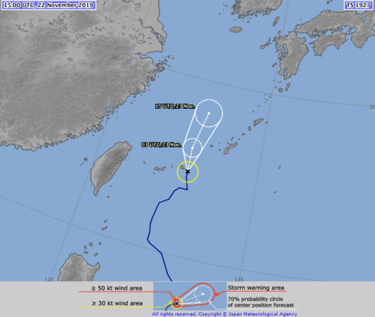


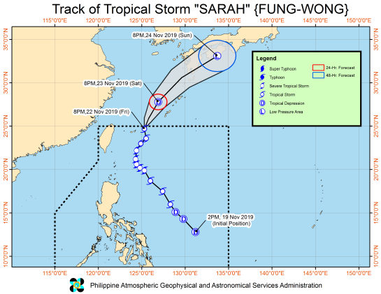


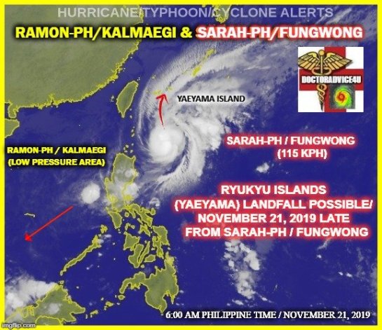


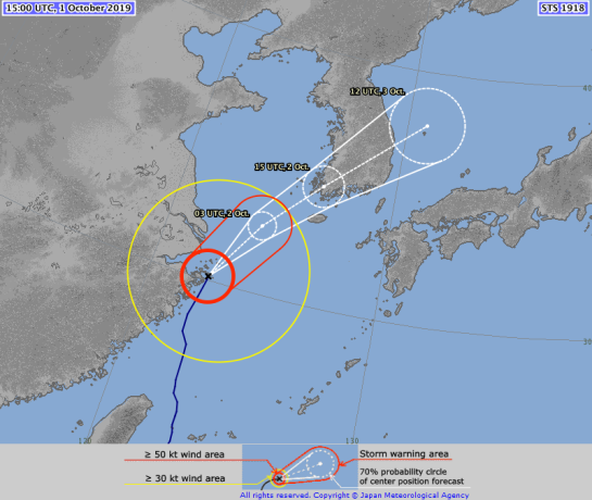
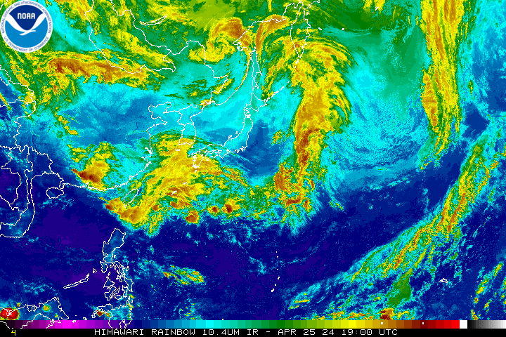


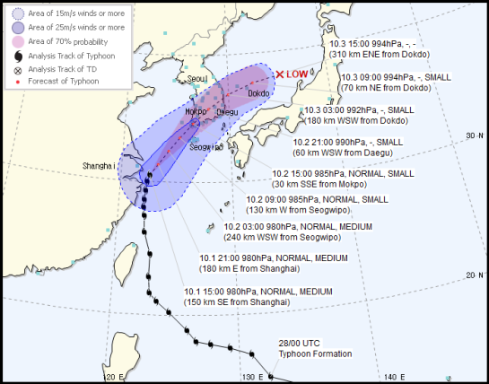


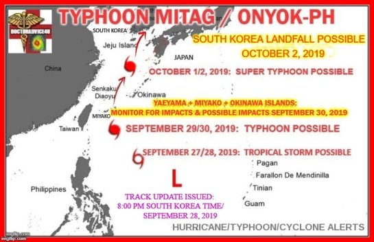


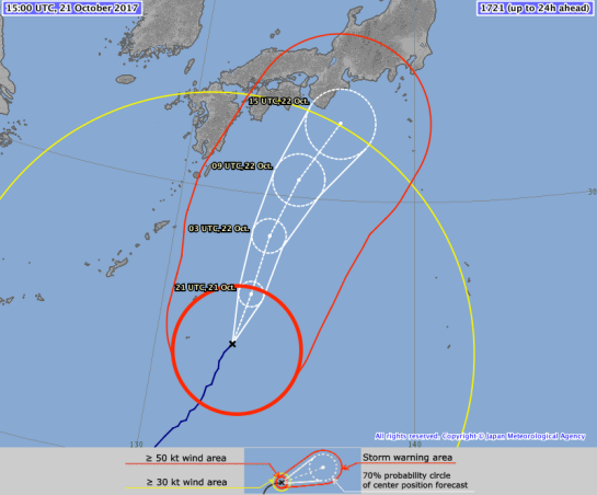


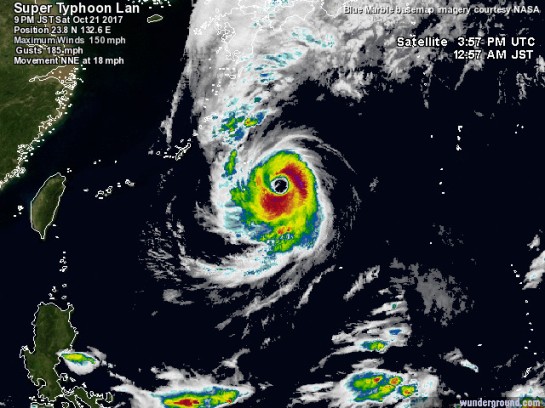


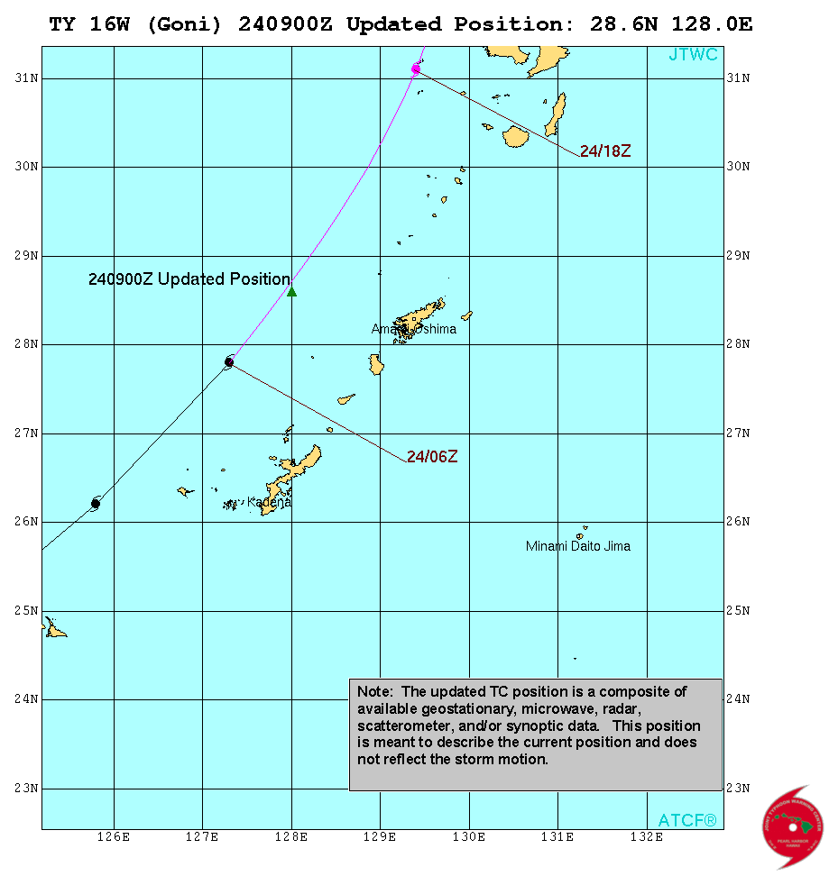


")


