STS 1918 (Mitag)
Issued at 15:50 UTC, 1 October 2019
<Analysis at 15 UTC, 1 October>
Scale
–
Intensity
–
Center position
N30°10′ (30.2°)
E122°30′ (122.5°)
Direction and speed of movement
N 20 km/h (11 kt)
Central pressure
980 hPa
Maximum wind speed near center
30 m/s (60 kt)
Maximum wind gust speed
45 m/s (85 kt)
≥ 50 kt wind area
ALL 110 km (60 NM)
≥ 30 kt wind area
NE 440 km (240 NM)
SW 330 km (180 NM)
<Forecast for 03 UTC, 2 October>
Intensity
–
Center position of probability circle
N32°35′ (32.6°)
E124°10′ (124.2°)
Direction and speed of movement
NNE 20 km/h (12 kt)
Central pressure
985 hPa
Maximum wind speed near center
30 m/s (55 kt)
Maximum wind gust speed
40 m/s (80 kt)
Radius of probability circle
60 km (30 NM)
Storm warning area
ALL 130 km (70 NM)
<Forecast for 15 UTC, 2 October>
Intensity
–
Center position of probability circle
N34°40′ (34.7°)
E126°30′ (126.5°)
Direction and speed of movement
NE 30 km/h (15 kt)
Central pressure
990 hPa
Maximum wind speed near center
25 m/s (50 kt)
Maximum wind gust speed
35 m/s (70 kt)
Radius of probability circle
90 km (50 NM)
<Forecast for 12 UTC, 3 October>
Intensity
–
LOW
Center position of probability circle
N37°50′ (37.8°)
E130°55′ (130.9°)
Direction and speed of movement
NE 30 km/h (15 kt)
Central pressure
992 hPa
Maximum sustained wind speed
23 m/s (45 kt)
Maximum wind gust speed
35 m/s (65 kt)
Radius of probability circle
170 km (90 NM)
xxxx
CHINA
Typhoon Message
20191002 01:12
National Meteorological Center No.1122
Analysis Time: Oct. 01th 17 UTC
Name of TC: MITAG
Num. of TC: 1918
Current Location: 30.4°N 122.6°E
Max. 10-min Wind Speed: 25m/s(90km/h)
Central Pressure: 985hPa
Radius of 34knots Winds: NE 300km SE 260km SW 200km NW 280km
Forecast movement: next 24hrs MITAG will moving NNE at speed of 25km/h
TAIWAN
2019/10/01 12:00, Severe Tropical Storm MITAG (201918) , Center Location 29.60N 122.20E, Movement: NNE 22KM/HR. Minimum Pressure 975 hpa, Maximum Wind Speed 30m/s, Gust 38m/s, Radius of 15m/s 180km, Radius of 25m/s 60km.
Severe Tropical Storm MITAG (201918)
》Analysis
1200UTC 01 October 2019
Center Location 29.60N 122.20E
Movement N 18km/hr
Minimum Pressure 975 hpa
Maximum Wind Speed 30 m/s
Gust 38 m/s
Radius of 15m/s 180km
Radius of 25m/s 60km
》Forecast
12 hours valid at:
0000UTC 02 October 2019
Center Position 31.70N 123.40E
Vector to 12 HR Position
NNE 22 km/hr
Minimum Pressure 980 hpa
Maximum Wind Speed 28 m/s
Gust 35 m/s
Radius of 15m/s 180km
Radius of 70% probability circle 50km
24 hours valid at:
1200UTC 02 October 2019
Center Position 33.90N 125.40E
Vector to 24 HR Position
NE 26 km/hr
Minimum Pressure 985 hpa
Maximum Wind Speed 25 m/s
Gust 33 m/s
Radius of 15m/s 180km
Radius of 70% probability circle 90km
36 hours valid at:
0000UTC 03 October 2019
Center Position 36.10N 127.80E
Vector to 36 HR Position
NE 27 km/hr
Minimum Pressure 988 hpa
Maximum Wind Speed 23 m/s
Gust 30 m/s
Radius of 15m/s 180km
Radius of 70% probability circle 130km
48 hours valid at:
1200UTC 03 October 2019
Center Position 37.10N 130.40E
Vector to 48 HR Position
ENE 21 km/hr
Minimum Pressure 992 hpa
Maximum Wind Speed 23 m/s
Gust 30 m/s
Radius of 15m/s 180km
Radius of 70% probability circle 170km
BECOMING EXTRATROPICAL LOW AT 48 HOURS
Tropical Storm MITAG is currently located near 30.0 N 122.4 E with maximum 1-min sustained winds of 60kts (69 mph). MITAG is forecast to affect land to the following likelihood(s) at the given lead time(s):
Red Alert Country(s) or Province(s) China probability for CAT 1 or above is 35% currently probability for TS is 100% currently
Yellow Alert Country(s) or Province(s) South Korea probability for TS is 95% in about 24 hours Japan probability for TS is 75% in about 36 hours North Korea probability for TS is 65% in about 48 hours Yellow Alert City(s) and Town(s) Ningbo (29.7 N, 121.5 E) probability for TS is 100% currently Mokpo (34.9 N, 126.4 E) probability for TS is 95% in about 24 hours Cheju (33.5 N, 126.5 E) probability for TS is 90% in about 24 hours Shanghai (31.2 N, 121.5 E) probability for TS is 85% within 12 hours Wenling (28.4 N, 121.4 E) probability for TS is 85% currently Ch’ungju (36.6 N, 127.5 E) probability for TS is 85% in about 36 hours Kunsan (36.0 N, 126.8 E) probability for TS is 85% in about 36 hours Taegu (35.9 N, 128.6 E) probability for TS is 85% in about 36 hours Pusan (35.2 N, 129.1 E) probability for TS is 80% in about 36 hours Akita (39.8 N, 140.2 E) probability for TS is 70% in about 72 hours Sakata (39.0 N, 140.0 E) probability for TS is 70% in about 72 hours Seoul (37.5 N, 126.9 E) probability for TS is 65% in about 36 hours Aomori (40.8 N, 140.8 E) probability for TS is 65% in about 96 hours Kanazawa (36.8 N, 136.8 E) probability for TS is 60% in about 72 hours Niigata (37.8 N, 139.2 E) probability for TS is 60% in about 72 hours Matsue (35.4 N, 133.0 E) probability for TS is 55% in about 72 hours Sendai (38.3 N, 140.9 E) probability for TS is 55% in about 72 hours
Green Alert Country(s) or Province(s) the Russian Federation probability for TS is 35% in about 96 hours Green Alert City(s) and Town(s) Miyako (39.7 N, 141.9 E) probability for TS is 50% in about 96 hours Hangzhou (30.3 N, 120.2 E) probability for TS is 45% currently Fukuoka (33.6 N, 130.4 E) probability for TS is 45% in about 48 hours Asahikawa (43.8 N, 142.4 E) probability for TS is 45% in about 96 hours Sapporo (43.1 N, 141.3 E) probability for TS is 45% in about 96 hours Kushiro (43.0 N, 144.4 E) probability for TS is 45% in about 96 hours Iwaki (37.0 N, 140.8 E) probability for TS is 45% in about 72 hours Jinhua (29.2 N, 120.0 E) probability for TS is 40% currently Obama (35.4 N, 135.8 E) probability for TS is 40% in about 72 hours Nagoya (35.2 N, 136.9 E) probability for TS is 35% in about 72 hours Tokyo (35.7 N, 139.8 E) probability for TS is 35% in about 72 hours
Note that
Red Alert (Severe) is CAT 1 or above to between 31% and 100% probability.
Yellow Alert (Elevated) is CAT 1 or above to between 10% and 30% probability, or TS to above 50% probability.
Green Alert (Low) is TS to between 31% and 50% probability.
CAT 1 means Typhoon strength winds of at least 74 mph, 119 km/h or 64 knots 1-min sustained.
TS means Tropical Storm strength winds of at least 39 mph, 63 km/h or 34 knots 1-min sustained.
WTJP31 RJTD 011500
WARNING 011500.
WARNING VALID 021500.
STORM WARNING.
SEVERE TROPICAL STORM 1918 MITAG (1918) 980 HPA
AT 30.2N 122.5E EAST CHINA SEA MOVING NORTH 11 KNOTS.
POSITION GOOD.
MAX WINDS 60 KNOTS NEAR CENTER.
RADIUS OF OVER 50 KNOT WINDS 60 MILES.
RADIUS OF OVER 30 KNOT WINDS 240 MILES NORTHEAST SEMICIRCLE AND 180
MILES ELSEWHERE.
FORECAST POSITION FOR 020300UTC AT 32.6N 124.2E WITH 30 MILES RADIUS
OF 70 PERCENT PROBABILITY CIRCLE.
985 HPA, MAX WINDS 55 KNOTS NEAR CENTER.
FORECAST POSITION FOR 021500UTC AT 34.7N 126.5E WITH 50 MILES RADIUS
OF 70 PERCENT PROBABILITY CIRCLE.
990 HPA, MAX WINDS 50 KNOTS NEAR CENTER.
JAPAN METEOROLOGICAL AGENCY.=
===========================================================================================================Do not use any information on this site for life or death decisions. All information is intended as supplementary to official sources. Kindly refer to your country’s official weather agency/government website for local warnings, advisories and bulletins.
Tropical Storm TAPAH is currently located near 32.7 N 127.9 E with maximum 1-min sustained winds of 55kts (63 mph). TAPAH is forecast to affect land to the following likelihood(s) at the given lead time(s): Yellow Alert Country(s) or Province(s) South Korea probability for TS is 100% currently Japan probability for CAT 1 or above is 25% within 12 hours probability for TS is 100% currently Yellow Alert City(s) and Town(s) Taegu (35.9 N, 128.6 E) probability for TS is 100% within 12 hours Pusan (35.2 N, 129.1 E) probability for TS is 100% currently Hiroshima (34.4 N, 132.4 E) probability for TS is 100% within 12 hours Fukuoka (33.6 N, 130.4 E) probability for TS is 100% currently Cheju (33.5 N, 126.5 E) probability for TS is 100% currently Saga (33.3 N, 130.3 E) probability for TS is 100% currently Nagasaki (32.8 N, 129.9 E) probability for TS is 100% currently Kumamoto (32.7 N, 130.7 E) probability for TS is 100% currently Kagoshima (31.5 N, 130.5 E) probability for TS is 100% currently Matsue (35.4 N, 133.0 E) probability for TS is 100% within 12 hours Mokpo (34.9 N, 126.4 E) probability for TS is 95% within 12 hours Kanazawa (36.8 N, 136.8 E) probability for TS is 85% in about 24 hours Ch’ungju (36.6 N, 127.5 E) probability for TS is 75% within 12 hours Kunsan (36.0 N, 126.8 E) probability for TS is 75% within 12 hours Obama (35.4 N, 135.8 E) probability for TS is 75% in about 24 hours Sapporo (43.1 N, 141.3 E) probability for TS is 75% in about 36 hours Aomori (40.8 N, 140.8 E) probability for TS is 75% in about 36 hours Akita (39.8 N, 140.2 E) probability for TS is 75% in about 36 hours Sakata (39.0 N, 140.0 E) probability for TS is 75% in about 36 hours Asahikawa (43.8 N, 142.4 E) probability for TS is 75% in about 36 hours Kushiro (43.0 N, 144.4 E) probability for TS is 75% in about 36 hours Miyako (39.7 N, 141.9 E) probability for TS is 65% in about 36 hours Tokushima (34.1 N, 134.6 E) probability for TS is 60% in about 24 hours Niigata (37.8 N, 139.2 E) probability for TS is 60% in about 24 hours
Green Alert City(s) and Town(s) Osaka (34.6 N, 135.5 E) probability for TS is 50% in about 24 hours Sendai (38.3 N, 140.9 E) probability for TS is 50% in about 36 hours Nagoya (35.2 N, 136.9 E) probability for TS is 35% in about 24 hours
Note that
Yellow Alert (Elevated) is CAT 1 or above to between 10% and 30% probability, or TS to above 50% probability.
Green Alert (Low) is TS to between 31% and 50% probability.
CAT 1 means Typhoon strength winds of at least 74 mph, 119 km/h or 64 knots 1-min sustained.
TS means Tropical Storm strength winds of at least 39 mph, 63 km/h or 34 knots 1-min sustained.
Current probability of Cat 1 (US scale) or above winds
MARITIME/SHIPPING
WTJP21 RJTD 221200
WARNING 221200.
WARNING VALID 231200.
WARNING IS UPDATED EVERY 6 HOURS.
STORM WARNING.
SEVERE TROPICAL STORM 1917 TAPAH (1917) 980 HPA
AT 33.6N 129.4E SEA AROUND TUSHIMA MOVING NORTHEAST 16 KNOTS.
POSITION FAIR.
MAX WINDS 60 KNOTS.
RADIUS OF OVER 50 KNOT WINDS 110 MILES SOUTHEAST SEMICIRCLE AND 80
MILES ELSEWHERE.
RADIUS OF OVER 30 KNOT WINDS 350 MILES SOUTHEAST SEMICIRCLE AND 300
MILES ELSEWHERE.
FORECAST POSITION FOR 230000UTC AT 37.5N 133.7E WITH 40 MILES RADIUS
OF 70 PERCENT PROBABILITY CIRCLE.
985 HPA, MAX WINDS 55 KNOTS.
FORECAST POSITION FOR 231200UTC AT 40.9N 139.3E WITH 70 MILES RADIUS
OF 70 PERCENT PROBABILITY CIRCLE.
990 HPA, MAX WINDS 50 KNOTS.
BECOMING EXTRATROPICAL LOW.
Do not use any information on this site for life or death decisions. All information is intended as supplementary to official sources. Kindly refer to your country’s official weather agency/government website for local warnings, advisories and bulletins.
WTPN32 PGTW 070900
MSGID/GENADMIN/JOINT TYPHOON WRNCEN PEARL HARBOR HI//
SUBJ/TYPHOON 15W (LINGLING) WARNING NR 022//
RMKS/
1. TYPHOON 15W (LINGLING) WARNING NR 022
02 ACTIVE TROPICAL CYCLONES IN NORTHWESTPAC
MAX SUSTAINED WINDS BASED ON ONE-MINUTE AVERAGE
WIND RADII VALID OVER OPEN WATER ONLY
—
WARNING POSITION:
070600Z — NEAR 37.9N 125.3E
MOVEMENT PAST SIX HOURS – 005 DEGREES AT 19 KTS
POSITION ACCURATE TO WITHIN 030 NM
POSITION BASED ON CENTER LOCATED BY SATELLITE
PRESENT WIND DISTRIBUTION:
MAX SUSTAINED WINDS – 065 KT, GUSTS 080 KT
WIND RADII VALID OVER OPEN WATER ONLY
BECOMING EXTRATROPICAL
RADIUS OF 064 KT WINDS – 045 NM NORTHEAST QUADRANT
060 NM SOUTHEAST QUADRANT
040 NM SOUTHWEST QUADRANT
045 NM NORTHWEST QUADRANT
RADIUS OF 050 KT WINDS – 085 NM NORTHEAST QUADRANT
110 NM SOUTHEAST QUADRANT
070 NM SOUTHWEST QUADRANT
085 NM NORTHWEST QUADRANT
RADIUS OF 034 KT WINDS – 155 NM NORTHEAST QUADRANT
195 NM SOUTHEAST QUADRANT
135 NM SOUTHWEST QUADRANT
155 NM NORTHWEST QUADRANT
REPEAT POSIT: 37.9N 125.3E
—
FORECASTS:
12 HRS, VALID AT:
071800Z — 43.4N 127.9E
MAX SUSTAINED WINDS – 045 KT, GUSTS 055 KT
WIND RADII VALID OVER OPEN WATER ONLY
EXTRATROPICAL
RADIUS OF 034 KT WINDS – 070 NM NORTHEAST QUADRANT
150 NM SOUTHEAST QUADRANT
020 NM SOUTHWEST QUADRANT
010 NM NORTHWEST QUADRANT
VECTOR TO 24 HR POSIT: 035 DEG/ 30 KTS
—
24 HRS, VALID AT:
080600Z — 48.3N 133.0E
MAX SUSTAINED WINDS – 035 KT, GUSTS 045 KT
WIND RADII VALID OVER OPEN WATER ONLY
EXTRATROPICAL
—
REMARKS: 070900Z POSITION NEAR 39.3N 125.9E.
07SEP19. TYPHOON (TY) 15W (LINGLING), LOCATED APPROXIMATELY 84 NM
WEST-NORTHWEST OF YONGSAN AIN, SOUTH KOREA, HAS TRACKED NORTHWARD AT 19 KNOTS OVER THE PAST SIX HOURS. ANIMATED ENHANCED INFRARED
SATELLITE IMAGERY DEPICTS A PARTIALLY-EXPOSED LOW-LEVEL CIRCULATION
CENTER (LLCC) WITH DEEP CONVECTION SHEARED OVER THE NORTHERN
SEMICIRCLE. A 070521Z GMI 89GHZ COLOR COMPOSITE MICROWAVE IMAGE
INDICATES TIGHTLY-CURVED BANDING (TCB) WRAPPING INTO A WELL-DEFINED
LLCC, WHICH SUPPORTS THE INITIAL POSITION OVER LAND WITH HIGH
CONFIDENCE. THE INITIAL INTENSITY IS ASSESSED AT 65 KNOTS BASED ON
AN UNOFFICIAL PGTW DVORAK ESTIMATE OF T3.5/4.0 (55/65 KNOTS), WHICH
IS CONSISTENT WITH THE TCB STRUCTURE. TY 15W IS FORECAST TO
ACCELERATE NORTH-NORTHEASTWARD THROUGH THE FORECAST PERIOD WHILE
UNDERGOING EXTRA-TROPICAL TRANSITION (ETT). THE SYSTEM IS EXPECTED
TO COMPLETE ETT BY TAU 12 AS IT TRACKS UNDER THE MIDLATITUDE JET.
DYNAMIC MODEL GUIDANCE REMAINS IN EXCELLENT AGREEMENT, THEREFORE,
THERE IS HIGH CONFIDENCE IN THE JTWC FORECAST TRACK. THIS IS THE
FINAL WARNING ON THIS SYSTEM BY THE JOINT TYPHOON WRNCEN PEARL
HARBOR HI. THE SYSTEM WILL BE CLOSELY MONITORED FOR SIGNS OF
REGENERATION. REFER TO TYPHOON 14W (FAXAI) WARNINGS (WTPN31 PGTW)
FOR SIX-HOURLY UPDATES.//
NNNN
TY 1913 (Lingling)
Issued at 07:00 UTC, 7 September 2019
<Analysis at 06 UTC, 7 September>
Scale
–
Intensity
–
Center position
N37°55′ (37.9°)
E125°20′ (125.3°)
Direction and speed of movement
N 40 km/h (21 kt)
Central pressure
970 hPa
Maximum wind speed near center
35 m/s (70 kt)
Maximum wind gust speed
50 m/s (100 kt)
≥ 50 kt wind area
ALL 170 km (90 NM)
≥ 30 kt wind area
E 560 km (300 NM)
W 300 km (160 NM)
<Forecast for 18 UTC, 7 September>
Intensity
–
Center position of probability circle
N44°20′ (44.3°)
E128°20′ (128.3°)
Direction and speed of movement
NNE 65 km/h (34 kt)
Central pressure
985 hPa
Maximum sustained wind speed
20 m/s (40 kt)
Maximum wind gust speed
30 m/s (60 kt)
Radius of probability circle
110 km (60 NM)
<Forecast for 06 UTC, 8 September>
Intensity
–
LOW
Center position of probability circle
N48°40′ (48.7°)
E132°30′ (132.5°)
Direction and speed of movement
NNE 45 km/h (25 kt)
Central pressure
984 hPa
Maximum sustained wind speed
18 m/s (35 kt)
Maximum wind gust speed
25 m/s (50 kt)
Radius of probability circle
150 km (80 NM)
xxxx
South Korea
No.13 LINGLING
Issued at(KST) : 2019.09.07. 16:00
Date(UTC)
Position
Central Pressure (hPa)
Maximum Sustained
Wind(m/s)
Radius of 15 m/s(km)
Intensity
Scale
Moving Direction
Moving Speed(km/h)
Radius of 70% probability(km)
Lat
(N)
Lon
(E)
m/s
km/h
2019.09.07. 06:00 Analysis
38.0
125.5
970
35
126
300
(S 210)
Strong
Medium
N
49
2019.09.07. 12:00 Forecast
40.9
127.1
975
32
115
280
(WNW 200)
Normal
Small
NNE
57
24
2019.09.07. 18:00 Forecast
43.7
129.1
980
29
104
250
(NW 170)
Normal
Small
NE
60
48
2019.09.08. 00:00 Forecast
46.4
132.1
985
24
86
NE
63
xxxx
Yellow Warning of Typhoon
06-09-2019Source: National Meteorological Center
The National Meteorological Center continued to release yellow warning of typhoon at 6:00 a.m. on September 6.
This year’s 13th typhoon Lingling is predicted to move northward direction at the speed of 25 km/h and enter southern Huanghai Sea in the night of September 6. It will make landfall from western Republic of Korea to southeastern Liaoning from the night of September 7 to the dawn of September 8 (severe tropical storm, scale 10-11, 25-30m/s).
From September 6 to 7, sea areas around Diaoyu Islands, East China Sea, and central Huanghai Sea will be exposed to scale 8-11 gale. Coastal regions of Shanghai, Jiangsu and Zhejiang, Hangzhou Bay, Yangtze River Estuary, and coastal regions of Taiwan Island will be exposed to scale 6-7 gale.
Taiwan Island, northeastern Zhejiang, and eastern Shandong Peninsula will be subject to moderate to heavy rain. There is rainstorm (100-120mm) in some regions. (Sep. 6)
Editor: Liu Shuqiao
CMA launched level four emergency response to address the impacts of typhoon Lingling
06-09-2019Source: China Meteorological Administration
The National Meteorological Center continued to issue yellow warning of typhoon on September 6. In order to address impacts incurred by typhoon Lingling, China Meteorological Administration (CMA) activated a level four emergency response at 8:30 a.m. on September 6. It is required that the relevant meteorological sectors attached to CMA enter the emergency position immediately and put corresponding meteorological services in place. The potential affected areas such as Jiangsu, Shandong, Liaoning, and Heilongjiang are expected to sustain or adjust the emergency state according to local realities. (Sep.6)
Typhoon LINGLING is currently located near 37.9 N 125.3 E with maximum 1-min sustained winds of 65 kts (75 mph). LINGLING is a category 1 storm on the Saffir Simpson Hurricane Wind Scale. LINGLING is forecast to affect land to the following likelihood(s) at the given lead time(s):
Red Alert Country(s) or Province(s) North Korea probability for CAT 1 or above is 100% currently probability for TS is 100% currently South Korea probability for CAT 1 or above is 45% currently probability for TS is 100% currently Red Alert City(s) and Town(s) Sariwon (38.5 N, 125.8 E) probability for CAT 1 or above is 100% currently probability for TS is 100% currently
Yellow Alert Country(s) or Province(s) China probability for TS is 95% currently the Russian Federation probability for TS is 70% in about 24 hours Yellow Alert City(s) and Town(s) P’yongyang (39.0 N, 125.8 E) probability for CAT 1 or above is 30% currently probability for TS is 100% currently Seoul (37.5 N, 126.9 E) probability for TS is 100% currently Ch’ungju (36.6 N, 127.5 E) probability for TS is 100% currently Kunsan (36.0 N, 126.8 E) probability for TS is 100% currently Kanggye (41.0 N, 126.6 E) probability for TS is 95% within 12 hours Sinuiju (40.1 N, 124.4 E) probability for TS is 95% within 12 hours Hamhung (39.9 N, 127.6 E) probability for TS is 95% within 12 hours Ch’ongjin (41.8 N, 129.8 E) probability for TS is 80% within 12 hours Mokpo (34.9 N, 126.4 E) probability for TS is 75% currently Vladivostok (43.1 N, 132.0 E) probability for TS is 55% in about 24 hours
Green Alert City(s) and Town(s) Khabarovsk (48.4 N, 135.1 E) probability for TS is 45% in about 24 hours Taegu (35.9 N, 128.6 E) probability for TS is 35% currently
Note that
Red Alert (Severe) is CAT 1 or above to between 31% and 100% probability.
Yellow Alert (Elevated) is CAT 1 or above to between 10% and 30% probability, or TS to above 50% probability.
Green Alert (Low) is TS to between 31% and 50% probability.
CAT 1 means Typhoon strength winds of at least 74 mph, 119 km/h or 64 knots 1-min sustained.
TS means Tropical Storm strength winds of at least 39 mph, 63 km/h or 34 knots 1-min sustained.
For graphical forecast information and further details please visit http://www.tropicalstormrisk.com/
Current probability of tropical storm winds
Current probability of Cat 1 (US scale) or above winds
WTJP22 RJTD 070600 WARNING 070600. WARNING VALID 080600. WARNING IS UPDATED EVERY 6 HOURS. TYPHOON WARNING. TYPHOON 1913 LINGLING (1913) 970 HPA AT 37.9N 125.3E KOREA MOVING NORTH 21 KNOTS. POSITION GOOD. MAX WINDS 70 KNOTS NEAR CENTER. RADIUS OF OVER 50 KNOT WINDS 90 MILES. RADIUS OF OVER 30 KNOT WINDS 300 MILES EAST SEMICIRCLE AND 160 MILES ELSEWHERE. FORECAST POSITION FOR 071800UTC AT 44.3N 128.3E WITH 60 MILES RADIUS OF 70 PERCENT PROBABILITY CIRCLE. 985 HPA, MAX WINDS 40 KNOTS. FORECAST POSITION FOR 080600UTC AT 48.7N 132.5E WITH 80 MILES RADIUS OF 70 PERCENT PROBABILITY CIRCLE. 984 HPA, MAX WINDS 35 KNOTS. BECOMING EXTRATROPICAL LOW.
Do not use any information on this site for life or death decisions. All information is intended as supplementary to official sources. Kindly refer to your country’s official weather agency/government website for local warnings, advisories and bulletins.
WTPN33 PGTW 160300
MSGID/GENADMIN/JOINT TYPHOON WRNCEN PEARL HARBOR HI//
SUBJ/TROPICAL STORM 11W (KROSA) WARNING NR 042//
RMKS/
1. TROPICAL STORM 11W (KROSA) WARNING NR 042
01 ACTIVE TROPICAL CYCLONE IN NORTHWESTPAC
MAX SUSTAINED WINDS BASED ON ONE-MINUTE AVERAGE
WIND RADII VALID OVER OPEN WATER ONLY
—
WARNING POSITION:
160000Z — NEAR 39.4N 134.9E
MOVEMENT PAST SIX HOURS – 020 DEGREES AT 18 KTS
POSITION ACCURATE TO WITHIN 060 NM
POSITION BASED ON CENTER LOCATED BY SATELLITE
PRESENT WIND DISTRIBUTION:
MAX SUSTAINED WINDS – 035 KT, GUSTS 045 KT
WIND RADII VALID OVER OPEN WATER ONLY
BECOMING EXTRATROPICAL
RADIUS OF 034 KT WINDS – 150 NM NORTHEAST QUADRANT
150 NM SOUTHEAST QUADRANT
115 NM SOUTHWEST QUADRANT
195 NM NORTHWEST QUADRANT
REPEAT POSIT: 39.4N 134.9E
—
FORECASTS:
12 HRS, VALID AT:
161200Z — 42.3N 137.5E
MAX SUSTAINED WINDS – 035 KT, GUSTS 045 KT
WIND RADII VALID OVER OPEN WATER ONLY
BECOMING EXTRATROPICAL
RADIUS OF 034 KT WINDS – 250 NM NORTHEAST QUADRANT
160 NM SOUTHEAST QUADRANT
090 NM SOUTHWEST QUADRANT
210 NM NORTHWEST QUADRANT
VECTOR TO 24 HR POSIT: 040 DEG/ 13 KTS
—
24 HRS, VALID AT:
170000Z — 44.3N 139.9E
MAX SUSTAINED WINDS – 035 KT, GUSTS 045 KT
WIND RADII VALID OVER OPEN WATER ONLY
EXTRATROPICAL
RADIUS OF 034 KT WINDS – 170 NM NORTHEAST QUADRANT
130 NM SOUTHEAST QUADRANT
030 NM SOUTHWEST QUADRANT
180 NM NORTHWEST QUADRANT
—
REMARKS:
160300Z POSITION NEAR 40.1N 135.6E.
16AUG19. TROPICAL STORM 11W (KROSA), LOCATED APPROXIMATELY 296 NM
WEST OF MISAWA, JAPAN, HAS TRACKED NORTH-NORTHEASTWARD AT 18
KNOTS OVER THE PAST SIX HOURS. ANIMATED MULTISPECTRAL SATELLITE
IMAGERY (MSI) SHOWS THE SYSTEM IS CONTINUING TO ERODE AS IT CONTINUES
TO TRACK THROUGH THE SEA OF JAPAN (SOJ). THE INITIAL POSITION IS
PLACED WITH LOW CONFIDENCE BASED ON A BROAD AND RAGGED LOW LEVEL
CIRCULATION (LLC) THAT IS POORLY-DEFINED IN MSI. THE INITIAL
INTENSITY OF 35 KNOTS IS IN LINE WITH A PARTIAL 160048Z METOP-B ASCAT
PASS SHOWING SWATHS OF 35 KNOT WIND BARBS SIGNIFICANTLY DISPLACED
FROM THE CENTER. UPPER LEVEL ANALYSIS INDICATES LOW (10-15 KNOT)
VERTICAL WIND SHEAR (VWS) AND STRONG POLEWARD OUTFLOW. SEA SURFACE
TEMPERATURES (SST) ARE BECOMING UNFAVORABLE (24-25 DEGREES CELSIUS).
TS 11W IS TRACKING ALONG THE NORTHWESTERN EDGE OF A SUBTROPICAL RIDGE
(STR) TO THE SOUTHEAST. TS 11W IS EXPECTED TO COMPLETE EXTRATROPICAL
TRANSITION BY TAU 12. THIS IS THE FINAL WARNING ON THIS SYSTEM BY THE
JOINT TYPHOON WRNCEN PEARL HARBOR HI. THE SYSTEM WILL BE CLOSELY
MONITORED FOR SIGNS OF REGENERATION. MAXIMUM SIGNIFICANT WAVE HEIGHT
AT 160000Z IS 13 FEET.//
NNNN
RUSSIA
Typhoon Krosa entered the Sea of Japan
In the Primorsky, Khabarovsk Territories and in the Jewish Autonomous Region a storm warning, heavy rains and strong winds …
The cyclone moves along the Sea of Japan, gradually weakening, and on Saturday night should turn away from Primorye towards Hokkaido Island and further into the Pacific Ocean. But under the influence of an active atmospheric front in the west of Primorsky Krai at night on August 17, very heavy rains. Rains on the coast will be accompanied by wind with gusts of up to 30 m / s. The height of the water level rise in the rivers will be from one to 3 meters, with the water coming out of the coast, flooding of settlements. Floods will be sharp, intense, and flooding of certain sections of roads is also possible.
In the Khabarovsk Territory and in the south of the Amur Region, there are also heavy and very heavy rains on weekends, thunderstorms wind up to 22 m / s. In the afternoon in the Amur Region about 20 degrees. On the Amur River and the rivers of the southern regions of the Jewish Autonomous Region and the Khabarovsk Territory, an additional rise in the water level is expected, including at Khabarovsk, as well as downstream of the Amur River.
On the islands, the weather is also getting worse, on Saturday in the south of Sakhalin and the Kuril ridge, heavy rain. And it’s not hot, up to 22 degrees on Sakhalin and no more than 20 degrees on the Kuril Islands.
In Kamchatka it rains, windy, in the afternoon 13 … 18 degrees.
It rains in the south of the region and forest fires in the north. In Yakutia, a special fire regime was introduced in ten regions of the Republic. But it will rain, in the afternoon 18 … 23 degrees, in the northeast up to 26 heat, on the Arctic coast 3 … 8 degrees.
Residents of the Magadan region will be pleased with the weather, without precipitation, although not hot, in the afternoon 15 … 20 degrees, at night in the continental regions freezing up to -2 degrees.
Tropical Storm KROSA is currently located near 39.4 N 134.9 E with maximum 1-min sustained winds of 35kts (40 mph). KROSA is forecast to affect land to the following likelihood(s) at the given lead time(s): Yellow Alert Country(s) or Province(s) the Russian Federation probability for TS is 100% within 12 hours Japan probability for TS is 100% within 12 hours Yellow Alert City(s) and Town(s) Sapporo (43.1 N, 141.3 E) probability for TS is 85% in about 24 hours Asahikawa (43.8 N, 142.4 E) probability for TS is 60% in about 24 hours
Green Alert City(s) and Town(s) Aomori (40.8 N, 140.8 E) probability for TS is 45% within 12 hours
Note that
Yellow Alert (Elevated) is CAT 1 or above to between 10% and 30% probability, or TS to above 50% probability.
Green Alert (Low) is TS to between 31% and 50% probability.
CAT 1 means Typhoon strength winds of at least 74 mph, 119 km/h or 64 knots 1-min sustained.
TS means Tropical Storm strength winds of at least 39 mph, 63 km/h or 34 knots 1-min sustained.
WTJP21 RJTD 160600
WARNING 160600.
WARNING VALID 170600.
WARNING IS UPDATED EVERY 6 HOURS.
GALE WARNING.
TROPICAL STORM 1910 KROSA (1910) 980 HPA
AT 40.9N 135.6E SEA OF JAPAN MOVING NORTHNORTHEAST 17 KNOTS.
POSITION FAIR.
MAX WINDS 45 KNOTS.
RADIUS OF OVER 30 KNOT WINDS 425 MILES EAST SEMICIRCLE AND 250 MILES
ELSEWHERE.
FORECAST POSITION FOR 161800UTC AT 43.6N 138.4E WITH 30 MILES RADIUS
OF 70 PERCENT PROBABILITY CIRCLE.
982 HPA, MAX WINDS 45 KNOTS.
BECOMING EXTRATROPICAL LOW.
FORECAST POSITION FOR 170600UTC AT 44.8N 140.6E WITH 70 MILES RADIUS
OF 70 PERCENT PROBABILITY CIRCLE.
988 HPA, MAX WINDS 40 KNOTS.
BECOMING EXTRATROPICAL LOW.
Do not use any information on this site for life or death decisions. All information is intended as supplementary to official sources. Kindly refer to your country’s official weather agency/government website for local warnings, advisories and bulletins.
WTPN31 PGTW 200900
MSGID/GENADMIN/JOINT TYPHOON WRNCEN PEARL HARBOR HI//
SUBJ/TROPICAL DEPRESSION 06W (DANAS) WARNING NR 017//
RMKS/
1. TROPICAL DEPRESSION 06W (DANAS) WARNING NR 017
DOWNGRADED FROM TROPICAL STORM 06W
01 ACTIVE TROPICAL CYCLONE IN NORTHWESTPAC
MAX SUSTAINED WINDS BASED ON ONE-MINUTE AVERAGE
WIND RADII VALID OVER OPEN WATER ONLY
—
WARNING POSITION:
200600Z — NEAR 34.7N 125.7E
MOVEMENT PAST SIX HOURS – 010 DEGREES AT 05 KTS
POSITION ACCURATE TO WITHIN 020 NM
POSITION BASED ON CENTER LOCATED BY A COMBINATION OF
SATELLITE AND SYNOPTIC DATA
PRESENT WIND DISTRIBUTION:
MAX SUSTAINED WINDS – 030 KT, GUSTS 040 KT
WIND RADII VALID OVER OPEN WATER ONLY
DISSIPATING AS A SIGNIFICANT TROPICAL CYCLONE OVER WATER
REPEAT POSIT: 34.7N 125.7E
—
FORECASTS:
12 HRS, VALID AT:
201800Z — 36.6N 127.1E
MAX SUSTAINED WINDS – 025 KT, GUSTS 035 KT
WIND RADII VALID OVER OPEN WATER ONLY
DISSIPATING AS A SIGNIFICANT TROPICAL CYCLONE OVER LAND
VECTOR TO 24 HR POSIT: 035 DEG/ 14 KTS
—
24 HRS, VALID AT:
210600Z — 39.0N 129.1E
MAX SUSTAINED WINDS – 020 KT, GUSTS 030 KT
WIND RADII VALID OVER OPEN WATER ONLY
DISSIPATED AS A SIGNIFICANT TROPICAL CYCLONE OVER WATER
—
REMARKS:
200900Z POSITION NEAR 35.2N 126.1E.
20JUL19. TROPICAL DEPRESSION 06W (DANAS), LOCATED APPROXIMATELY 84 NM
SOUTH-SOUTHWEST OF KUNSAN AB, HAS TRACKED NORTH-NORTHEASTWARD AT 05
KNOTS OVER THE PAST SIX HOURS. MAXIMUM SIGNIFICANT WAVE HEIGHT AT
200600Z IS 14 FEET. NEXT WARNINGS AT 201500Z, 202100Z AND 210300Z.//
NNNN
Tropical Depression DANAS is currently located near 34.7 N 125.7 E with maximum 1-min sustained winds of 30kts (35 mph). DANAS is forecast to affect land to the following likelihood(s) at the given lead time(s): Yellow Alert Country(s) or Province(s) South Korea probability for TS is 70% currently Yellow Alert City(s) and Town(s) Mokpo (34.9 N, 126.4 E) probability for TS is 60% currently
Note that
Yellow Alert (Elevated) is CAT 1 or above to between 10% and 30% probability, or TS to above 50% probability.
CAT 1 means Typhoon strength winds of at least 74 mph, 119 km/h or 64 knots 1-min sustained.
TS means Tropical Storm strength winds of at least 39 mph, 63 km/h or 34 knots 1-min sustained.
WTJP21 RJTD 201200
WARNING 201200.
WARNING VALID 211200.
WARNING IS UPDATED EVERY 6 HOURS.
GALE WARNING.
TROPICAL STORM 1905 DANAS (1905) 994 HPA
AT 35.5N 126.3E YELLOW SEA MOVING NORTHNORTHEAST 09 KNOTS.
POSITION GOOD.
MAX WINDS 35 KNOTS.
RADIUS OF OVER 30 KNOT WINDS 350 MILES EAST SEMICIRCLE AND 150 MILES
ELSEWHERE.
FORECAST POSITION FOR 210000UTC AT 38.1N 128.6E WITH 30 MILES RADIUS
OF 70 PERCENT PROBABILITY CIRCLE.
994 HPA, MAX WINDS 35 KNOTS.
FORECAST POSITION FOR 211200UTC AT 40.4N 130.2E WITH 40 MILES RADIUS
OF 70 PERCENT PROBABILITY CIRCLE.
996 HPA, MAX WINDS 30 KNOTS.
BECOMING EXTRATROPICAL LOW.
Do not use any information on this site for life or death decisions. All information is intended as supplementary to official sources. Kindly refer to your country’s official weather agency/government website for local warnings, advisories and bulletins.
Tropical Storm KONG-REY is currently located near 25.5 N 126.6 E with maximum 1-min sustained winds of 60kts (69 mph). KONG-REY is forecast to affect land to the following likelihood(s) at the given lead time(s): Yellow Alert Country(s) or Province(s) South Korea probability for CAT 1 or above is 10% in about 36 hours probability for TS is 100% in about 24 hours Japan probability for TS is 100% in about 36 hours China probability for TS is 70% within 12 hours North Korea probability for TS is 65% in about 48 hours Yellow Alert City(s) and Town(s) Okinawa (26.3 N, 127.8 E) probability for TS is 100% currently Cheju (33.5 N, 126.5 E) probability for TS is 100% in about 36 hours Taegu (35.9 N, 128.6 E) probability for TS is 100% in about 36 hours Pusan (35.2 N, 129.1 E) probability for TS is 100% in about 36 hours Nagasaki (32.8 N, 129.9 E) probability for TS is 95% in about 36 hours Mokpo (34.9 N, 126.4 E) probability for TS is 95% in about 36 hours Fukuoka (33.6 N, 130.4 E) probability for TS is 95% in about 36 hours Saga (33.3 N, 130.3 E) probability for TS is 95% in about 36 hours Matsue (35.4 N, 133.0 E) probability for TS is 90% in about 48 hours Ch’ungju (36.6 N, 127.5 E) probability for TS is 85% in about 36 hours Kunsan (36.0 N, 126.8 E) probability for TS is 85% in about 36 hours Kumamoto (32.7 N, 130.7 E) probability for TS is 85% in about 36 hours Hiroshima (34.4 N, 132.4 E) probability for TS is 85% in about 48 hours Kagoshima (31.5 N, 130.5 E) probability for TS is 80% in about 36 hours Kanazawa (36.8 N, 136.8 E) probability for TS is 70% in about 72 hours Kushiro (43.0 N, 144.4 E) probability for TS is 70% in about 72 hours Aomori (40.8 N, 140.8 E) probability for TS is 70% in about 72 hours Akita (39.8 N, 140.2 E) probability for TS is 70% in about 72 hours Miyako (39.7 N, 141.9 E) probability for TS is 70% in about 72 hours Sakata (39.0 N, 140.0 E) probability for TS is 70% in about 72 hours Sendai (38.3 N, 140.9 E) probability for TS is 70% in about 72 hours Niigata (37.8 N, 139.2 E) probability for TS is 70% in about 72 hours Sapporo (43.1 N, 141.3 E) probability for TS is 65% in about 72 hours Iwaki (37.0 N, 140.8 E) probability for TS is 65% in about 72 hours Seoul (37.5 N, 126.9 E) probability for TS is 60% in about 48 hours Asahikawa (43.8 N, 142.4 E) probability for TS is 60% in about 72 hours Obama (35.4 N, 135.8 E) probability for TS is 55% in about 48 hours Nagoya (35.2 N, 136.9 E) probability for TS is 55% in about 72 hours
Green Alert Country(s) or Province(s) the Russian Federation probability for TS is 40% in about 72 hours Green Alert City(s) and Town(s) Tokushima (34.1 N, 134.6 E) probability for TS is 50% in about 48 hours Osaka (34.6 N, 135.5 E) probability for TS is 45% in about 48 hours Tokyo (35.7 N, 139.8 E) probability for TS is 40% in about 72 hours Shizuoka (35.0 N, 138.5 E) probability for TS is 40% in about 72 hours
Note that
Yellow Alert (Elevated) is CAT 1 or above to between 10% and 30% probability, or TS to above 50% probability.
Green Alert (Low) is TS to between 31% and 50% probability.
CAT 1 means Typhoon strength winds of at least 74 mph, 119 km/h or 64 knots 1-min sustained.
TS means Tropical Storm strength winds of at least 39 mph, 63 km/h or 34 knots 1-min sustained.
WTJP22 RJTD 041200 WARNING 041200. WARNING VALID 051200. WARNING IS UPDATED EVERY 6 HOURS. TYPHOON WARNING. TYPHOON 1825 KONG-REY (1825) 965 HPA AT 25.5N 126.6E SEA SOUTH OF OKINAWA MOVING NORTHNORTHWEST 13 KNOTS. POSITION GOOD. MAX WINDS 70 KNOTS NEAR CENTER. RADIUS OF OVER 50 KNOT WINDS 100 MILES. RADIUS OF OVER 30 KNOT WINDS 350 MILES WEST SEMICIRCLE AND 300 MILES ELSEWHERE. FORECAST POSITION FOR 050000UTC AT 28.0N 125.6E WITH 40 MILES RADIUS OF 70 PERCENT PROBABILITY CIRCLE. 965 HPA, MAX WINDS 70 KNOTS NEAR CENTER. FORECAST POSITION FOR 051200UTC AT 30.9N 126.0E WITH 80 MILES RADIUS OF 70 PERCENT PROBABILITY CIRCLE. 965 HPA, MAX WINDS 70 KNOTS NEAR CENTER. EXTENDED OUTLOOK. FORECAST POSITION FOR 061200UTC AT 38.3N 132.4E WITH 150 MILES RADIUS OF 70 PERCENT PROBABILITY CIRCLE. 970 HPA, MAX WINDS 65 KNOTS NEAR CENTER. FORECAST POSITION FOR 071200UTC AT 43.4N 149.8E WITH 220 MILES RADIUS OF 70 PERCENT PROBABILITY CIRCLE. 984 HPA, MAX WINDS 50 KNOTS. BECOMING EXTRATROPICAL LOW.
Do not use any information on this site for life or death decisions. All information is intended as supplementary to official sources. Kindly refer to your country’s official weather agency/government website for local warnings, advisories and bulletins.
Typhoon TRAMI is currently located near 27.9 N 128.4 E with maximum 1-min sustained winds of 90 kts (104 mph). TRAMI is a category 2 storm on the Saffir Simpson Hurricane Wind Scale. TRAMI is forecast to affect land to the following likelihood(s) at the given lead time(s): Red Alert Country(s) or Province(s) Japan probability for CAT 1 or above is 100% within 12 hours probability for TS is 100% within 12 hours Red Alert City(s) and Town(s) Kagoshima (31.5 N, 130.5 E) probability for CAT 1 or above is 95% within 12 hours probability for TS is 100% within 12 hours Tokushima (34.1 N, 134.6 E) probability for CAT 1 or above is 90% in about 24 hours probability for TS is 100% in about 24 hours Nagoya (35.2 N, 136.9 E) probability for CAT 1 or above is 80% in about 24 hours probability for TS is 100% in about 24 hours Osaka (34.6 N, 135.5 E) probability for CAT 1 or above is 80% in about 24 hours probability for TS is 100% in about 24 hours Shiono-misaki (33.5 N, 135.8 E) probability for CAT 1 or above is 80% in about 24 hours probability for TS is 100% in about 24 hours Miyako (39.7 N, 141.9 E) probability for CAT 1 or above is 80% in about 36 hours probability for TS is 100% in about 36 hours Sendai (38.3 N, 140.9 E) probability for CAT 1 or above is 80% in about 36 hours probability for TS is 100% in about 36 hours Niigata (37.8 N, 139.2 E) probability for CAT 1 or above is 80% in about 36 hours probability for TS is 100% in about 36 hours Iwaki (37.0 N, 140.8 E) probability for CAT 1 or above is 80% in about 36 hours probability for TS is 100% in about 36 hours Tokyo (35.7 N, 139.8 E) probability for CAT 1 or above is 80% in about 36 hours probability for TS is 100% in about 36 hours Obama (35.4 N, 135.8 E) probability for CAT 1 or above is 75% in about 24 hours probability for TS is 100% in about 24 hours Sakata (39.0 N, 140.0 E) probability for CAT 1 or above is 60% in about 36 hours probability for TS is 100% in about 36 hours Kanazawa (36.8 N, 136.8 E) probability for CAT 1 or above is 50% in about 36 hours probability for TS is 100% in about 24 hours Akita (39.8 N, 140.2 E) probability for CAT 1 or above is 35% in about 36 hours probability for TS is 95% in about 36 hours
Yellow Alert City(s) and Town(s) Nagasaki (32.8 N, 129.9 E) probability for TS is 100% within 12 hours Kumamoto (32.7 N, 130.7 E) probability for CAT 1 or above is 25% in about 24 hours probability for TS is 100% within 12 hours Okinawa (26.3 N, 127.8 E) probability for TS is 100% currently Matsue (35.4 N, 133.0 E) probability for TS is 100% in about 24 hours Hiroshima (34.4 N, 132.4 E) probability for TS is 100% in about 24 hours Fukuoka (33.6 N, 130.4 E) probability for TS is 100% within 12 hours Saga (33.3 N, 130.3 E) probability for TS is 100% within 12 hours Shizuoka (35.0 N, 138.5 E) probability for CAT 1 or above is 10% in about 24 hours probability for TS is 100% in about 24 hours Kushiro (43.0 N, 144.4 E) probability for TS is 95% in about 36 hours Aomori (40.8 N, 140.8 E) probability for CAT 1 or above is 15% in about 36 hours probability for TS is 90% in about 36 hours Asahikawa (43.8 N, 142.4 E) probability for TS is 60% in about 36 hours
Green Alert Country(s) or Province(s) South Korea probability for TS is 50% in about 24 hours Green Alert City(s) and Town(s) Pusan (35.2 N, 129.1 E) probability for TS is 45% in about 24 hours
Note that
Red Alert (Severe) is CAT 1 or above to between 31% and 100% probability.
Yellow Alert (Elevated) is CAT 1 or above to between 10% and 30% probability, or TS to above 50% probability.
Green Alert (Low) is TS to between 31% and 50% probability.
CAT 1 means Typhoon strength winds of at least 74 mph, 119 km/h or 64 knots 1-min sustained.
TS means Tropical Storm strength winds of at least 39 mph, 63 km/h or 34 knots 1-min sustained.
Source: http://www.jma.go.jp/en/seawarn/ WTJP31 RJTD 291500 WARNING 291500. WARNING VALID 301500. TYPHOON WARNING. TYPHOON 1824 TRAMI (1824) 950 HPA AT 28.4N 128.5E EAST CHINA SEA MOVING NORTHNORTHEAST 14 KNOTS. POSITION GOOD. MAX WINDS 85 KNOTS NEAR CENTER. RADIUS OF OVER 50 KNOT WINDS 150 MILES SOUTHEAST SEMICIRCLE AND 120 MILES ELSEWHERE. RADIUS OF OVER 30 KNOT WINDS 350 MILES SOUTHWEST SEMICIRCLE AND 300 MILES ELSEWHERE. FORECAST POSITION FOR 300300UTC AT 31.5N 131.9E WITH 40 MILES RADIUS OF 70 PERCENT PROBABILITY CIRCLE. 950 HPA, MAX WINDS 85 KNOTS NEAR CENTER. FORECAST POSITION FOR 301500UTC AT 36.5N 137.7E WITH 80 MILES RADIUS OF 70 PERCENT PROBABILITY CIRCLE. 960 HPA, MAX WINDS 75 KNOTS NEAR CENTER.
Do not use any information on this site for life or death decisions. All information is intended as supplementary to official sources. Kindly refer to your country’s official weather agency/government website for local warnings, advisories and bulletins.
Tropical Storm YAGI is currently located near 20.6 N 133.1 E with maximum 1-min sustained winds of 35kts (40 mph). YAGI is forecast to affect land to the following likelihood(s) at the given lead time(s): Green Alert City(s) and Town(s) Okinawa (26.3 N, 127.8 E) probability for TS is 50% in about 48 hours
Note that
Green Alert (Low) is TS to between 31% and 50% probability.
TS means Tropical Storm strength winds of at least 39 mph, 63 km/h or 34 knots 1-min sustained.
WTJP21 RJTD 091200
WARNING 091200.
WARNING VALID 101200.
WARNING IS UPDATED EVERY 6 HOURS.
GALE WARNING.
TROPICAL STORM 1814 YAGI (1814) 994 HPA
AT 20.9N 133.4E SEA SOUTH OF JAPAN ALMOST STATIONARY.
POSITION FAIR.
MAX WINDS 35 KNOTS NEAR CENTER.
RADIUS OF OVER 30 KNOT WINDS 300 MILES SOUTH SEMICIRCLE AND 120 MILES
ELSEWHERE.
FORECAST POSITION FOR 101200UTC AT 23.9N 132.1E WITH 50 MILES RADIUS
OF 70 PERCENT PROBABILITY CIRCLE.
994 HPA, MAX WINDS 35 KNOTS NEAR CENTER.
EXTENDED OUTLOOK.
FORECAST POSITION FOR 111200UTC AT 27.1N 128.3E WITH 110 MILES RADIUS
OF 70 PERCENT PROBABILITY CIRCLE.
994 HPA, MAX WINDS 35 KNOTS NEAR CENTER.
FORECAST POSITION FOR 121200UTC AT 31.0N 124.4E WITH 140 MILES RADIUS
OF 70 PERCENT PROBABILITY CIRCLE.
990 HPA, MAX WINDS 45 KNOTS NEAR CENTER.
Do not use any information on this site for life or death decisions. All information is intended as supplementary to official sources. Kindly refer to your country’s official weather agency/government website for local warnings, advisories and bulletins.
Tropical Storm PRAPIROON is currently located near 34.6 N 129.8 E with maximum 1-min sustained winds of 60kts (69 mph). PRAPIROON is forecast to affect land to the following likelihood(s) at the given lead time(s):
Red Alert Country(s) or Province(s) Japan probability for CAT 1 or above is 35% currently probability for TS is 100% currently
Yellow Alert Country(s) or Province(s) South Korea probability for TS is 100% currently Yellow Alert City(s) and Town(s) Matsue (35.4 N, 133.0 E) probability for TS is 100% within 12 hours Pusan (35.2 N, 129.1 E) probability for TS is 100% currently Hiroshima (34.4 N, 132.4 E) probability for TS is 100% within 12 hours Fukuoka (33.6 N, 130.4 E) probability for TS is 100% currently Saga (33.3 N, 130.3 E) probability for TS is 100% currently Nagasaki (32.8 N, 129.9 E) probability for TS is 100% currently Kumamoto (32.7 N, 130.7 E) probability for TS is 100% currently Aomori (40.8 N, 140.8 E) probability for TS is 95% in about 36 hours Akita (39.8 N, 140.2 E) probability for TS is 90% in about 36 hours Sapporo (43.1 N, 141.3 E) probability for TS is 90% in about 36 hours Sakata (39.0 N, 140.0 E) probability for TS is 80% in about 36 hours Miyako (39.7 N, 141.9 E) probability for TS is 80% in about 48 hours Taegu (35.9 N, 128.6 E) probability for TS is 75% within 12 hours Kanazawa (36.8 N, 136.8 E) probability for TS is 70% in about 24 hours Asahikawa (43.8 N, 142.4 E) probability for TS is 70% in about 48 hours Kushiro (43.0 N, 144.4 E) probability for TS is 70% in about 48 hours Niigata (37.8 N, 139.2 E) probability for TS is 55% in about 36 hours
Green Alert Country(s) or Province(s) the Russian Federation probability for TS is 45% in about 48 hours Green Alert City(s) and Town(s) Kagoshima (31.5 N, 130.5 E) probability for TS is 50% currently Obama (35.4 N, 135.8 E) probability for TS is 50% in about 24 hours Sendai (38.3 N, 140.9 E) probability for TS is 50% in about 36 hours Tokushima (34.1 N, 134.6 E) probability for TS is 35% within 12 hours
Note that
Red Alert (Severe) is CAT 1 or above to between 31% and 100% probability.
Yellow Alert (Elevated) is CAT 1 or above to between 10% and 30% probability, or TS to above 50% probability.
Green Alert (Low) is TS to between 31% and 50% probability.
CAT 1 means Typhoon strength winds of at least 74 mph, 119 km/h or 64 knots 1-min sustained.
TS means Tropical Storm strength winds of at least 39 mph, 63 km/h or 34 knots 1-min sustained.
WTJP31 RJTD 031500
WARNING 031500.
WARNING VALID 041500.
STORM WARNING.
SEVERE TROPICAL STORM 1807 PRAPIROON (1807) 975 HPA
AT 35.0N 130.2E SEA AROUND TUSHIMA MOVING NORTHEAST 14 KNOTS.
POSITION GOOD.
MAX WINDS 55 KNOTS NEAR CENTER.
RADIUS OF OVER 50 KNOT WINDS 50 MILES.
RADIUS OF OVER 30 KNOT WINDS 240 MILES EAST SEMICIRCLE AND 120 MILES
ELSEWHERE.
FORECAST POSITION FOR 040300UTC AT 38.0N 133.4E WITH 40 MILES RADIUS
OF 70 PERCENT PROBABILITY CIRCLE.
985 HPA, MAX WINDS 45 KNOTS NEAR CENTER.
FORECAST POSITION FOR 041500UTC AT 40.6N 137.0E WITH 80 MILES RADIUS
OF 70 PERCENT PROBABILITY CIRCLE.
986 HPA, MAX WINDS 45 KNOTS.
BECOMING EXTRATROPICAL LOW.
Do not use any information on this site for life or death decisions. All information is intended as supplementary to official sources. Kindly refer to your country’s official weather agency/government website for local warnings, advisories and bulletins.
Typhoon LAN is currently located near 23.8 N 132.6 E with maximum 1-min sustained winds of 130 kts (150 mph). LAN is a category 4 storm on the Saffir Simpson Hurricane Wind Scale. LAN is forecast to affect land to the following likelihood(s) at the given lead time(s):
Red Alert Country(s) or Province(s) Japan probability for CAT 1 or above is 90% in about 36 hours probability for TS is 100% within 12 hours Red Alert City(s) and Town(s) Iwaki (37.0 N, 140.8 E) probability for CAT 1 or above is 90% in about 36 hours probability for TS is 100% in about 36 hours Tokyo (35.7 N, 139.8 E) probability for CAT 1 or above is 90% in about 36 hours probability for TS is 100% in about 36 hours Shizuoka (35.0 N, 138.5 E) probability for CAT 1 or above is 90% in about 36 hours probability for TS is 100% in about 24 hours Shiono-misaki (33.5 N, 135.8 E) probability for CAT 1 or above is 75% in about 36 hours probability for TS is 100% in about 24 hours Sendai (38.3 N, 140.9 E) probability for CAT 1 or above is 55% in about 36 hours probability for TS is 100% in about 36 hours Miyako (39.7 N, 141.9 E) probability for CAT 1 or above is 45% in about 48 hours probability for TS is 100% in about 36 hours Nagoya (35.2 N, 136.9 E) probability for CAT 1 or above is 45% in about 36 hours probability for TS is 100% in about 24 hours
Yellow Alert City(s) and Town(s) Saga (33.3 N, 130.3 E) probability for TS is 100% in about 24 hours Kumamoto (32.7 N, 130.7 E) probability for TS is 100% in about 24 hours Kagoshima (31.5 N, 130.5 E) probability for TS is 100% within 12 hours Niigata (37.8 N, 139.2 E) probability for CAT 1 or above is 25% in about 36 hours probability for TS is 100% in about 36 hours Kanazawa (36.8 N, 136.8 E) probability for TS is 100% in about 36 hours Matsue (35.4 N, 133.0 E) probability for TS is 100% in about 24 hours Obama (35.4 N, 135.8 E) probability for TS is 100% in about 24 hours Osaka (34.6 N, 135.5 E) probability for CAT 1 or above is 10% in about 36 hours probability for TS is 100% in about 24 hours Hiroshima (34.4 N, 132.4 E) probability for TS is 100% in about 24 hours Tokushima (34.1 N, 134.6 E) probability for TS is 100% in about 24 hours Kushiro (43.0 N, 144.4 E) probability for TS is 100% in about 48 hours Aomori (40.8 N, 140.8 E) probability for TS is 100% in about 36 hours Akita (39.8 N, 140.2 E) probability for TS is 100% in about 36 hours Sakata (39.0 N, 140.0 E) probability for CAT 1 or above is 20% in about 48 hours probability for TS is 100% in about 36 hours Okinawa (26.3 N, 127.8 E) probability for TS is 95% within 12 hours Fukuoka (33.6 N, 130.4 E) probability for TS is 95% in about 24 hours Nagasaki (32.8 N, 129.9 E) probability for TS is 95% in about 24 hours Asahikawa (43.8 N, 142.4 E) probability for TS is 85% in about 48 hours Sapporo (43.1 N, 141.3 E) probability for TS is 85% in about 48 hours
Green Alert Country(s) or Province(s) South Korea probability for TS is 45% in about 36 hours the Russian Federation probability for TS is 40% in about 48 hours Green Alert City(s) and Town(s) Pusan (35.2 N, 129.1 E) probability for TS is 35% in about 24 hours
Note that
Red Alert (Severe) is CAT 1 or above to between 31% and 100% probability.
Yellow Alert (Elevated) is CAT 1 or above to between 10% and 30% probability, or TS to above 50% probability.
Green Alert (Low) is TS to between 31% and 50% probability.
CAT 1 means Typhoon strength winds of at least 74 mph, 119 km/h or 64 knots 1-min sustained.
TS means Tropical Storm strength winds of at least 39 mph, 63 km/h or 34 knots 1-min sustained.
WTJP32 RJTD 211500 WARNING 211500. WARNING VALID 221500. TYPHOON WARNING. TYPHOON 1721 LAN (1721) 925 HPA AT 24.5N 132.9E SEA SOUTH OF JAPAN MOVING NORTHNORTHEAST 15 KNOTS. POSITION GOOD. MAX WINDS 95 KNOTS NEAR CENTER. RADIUS OF OVER 50 KNOT WINDS 150 MILES SOUTHEAST SEMICIRCLE AND 120 MILES ELSEWHERE. RADIUS OF OVER 30 KNOT WINDS 600 MILES WEST SEMICIRCLE AND 500 MILES ELSEWHERE. FORECAST POSITION FOR 220300UTC AT 28.5N 133.9E WITH 40 MILES RADIUS OF 70 PERCENT PROBABILITY CIRCLE. 925 HPA, MAX WINDS 95 KNOTS NEAR CENTER. FORECAST POSITION FOR 221500UTC AT 32.9N 136.6E WITH 80 MILES RADIUS OF 70 PERCENT PROBABILITY CIRCLE. 950 HPA, MAX WINDS 80 KNOTS NEAR CENTER.
JAPAN METEOROLOGICAL AGENCY.=
METAREA11 / HIGH_SEAS_FORECAST_JAPAN / 1200
WWJP25 RJTD 211200
WARNING AND SUMMARY 211200.
WARNING VALID 221200.
WARNING IS UPDATED EVERY 6 HOURS.
GALE WARNING.
DEVELOPING LOW 1004 HPA
AT 54N 138E SEA OF OKHOTSK MOVING NORTHNORTHEAST 15 KNOTS.
OCCLUDED FRONT FROM 54N 138E TO 53N 141E 52N 142E.
WARM FRONT FROM 52N 142E TO 49N 144E 46N 146E.
COLD FRONT FROM 52N 142E TO 49N 142E 44N 138E 41N 130E.
WINDS 30 TO 35 KNOTS WITHIN 800 MILES OF LOW SOUTHEAST SEMICIRCLE AND
300 MILES ELSEWHERE.
GALE WARNING.
NORTHERLY TO NORTHEASTERLY WINDS 30 TO 40 KNOTS PREVAILING OVER
WATERS BOUNDED BY 35N 129E 30N 130E 28N 125E 20N 120E 23N 117E 26N
120E 32N 122E 35N 129E.
WARNING.
TROPICAL DEPRESSION 1006 HPA
AT 11.6N 148.3E MARIANAS MOVING WESTSOUTHWEST 07 KNOTS.
POSITION POOR.
MAX WINDS 30 KNOTS NEAR CENTER.
WARNING.
DENSE FOG OBSERVED LOCALLY OVER SEA OF OKHOTSK NORTHERN PART OF SEA
OF JAPAN.
WARNING.
DENSE FOG OBSERVED LOCALLY OVER WATERS BOUNDED BY 36N 141E 40N 142E
42N 140E 42N 143E 47N 152E 50N 155E 40N 155E 34N 180E 29N 180E 29N
170E 29N 155E 36N 141E.
SUMMARY.
HIGH 1034 HPA AT 47N 159E ALMOST STATIONARY.
STATIONARY FRONT FROM 30N 130E TO 32N 134E 34N 140E 36N 146E 35N 152E
34N 157E.
REMARKS.
TYPHOON 1721 LAN (1721) 925 HPA AT 23.8N 132.5E : SEE TROPICAL
CYCLONE WARNING.
Do not use any information on this site for life or death decisions. All information is intended as supplementary to official sources. Kindly refer to your country’s official weather agency/government website for local warnings, advisories and bulletins.
WTPN31 PGTW 171500
MSGID/GENADMIN/JOINT TYPHOON WRNCEN PEARL HARBOR HI//
SUBJ/TROPICAL CYCLONE WARNING//
RMKS/
1. TROPICAL STORM 20W (TALIM) WARNING NR 036
01 ACTIVE TROPICAL CYCLONE IN NORTHWESTPAC
MAX SUSTAINED WINDS BASED ON ONE-MINUTE AVERAGE
WIND RADII VALID OVER OPEN WATER ONLY
—
WARNING POSITION:
171200Z — NEAR 34.1N 134.4E
MOVEMENT PAST SIX HOURS – 050 DEGREES AT 26 KTS
POSITION ACCURATE TO WITHIN 040 NM
POSITION BASED ON CENTER LOCATED BY A COMBINATION OF
SATELLITE, RADAR AND SYNOPTIC DATA
PRESENT WIND DISTRIBUTION:
MAX SUSTAINED WINDS – 055 KT, GUSTS 070 KT
WIND RADII VALID OVER OPEN WATER ONLY
BECOMING EXTRATROPICAL
RADIUS OF 050 KT WINDS – 055 NM NORTHEAST QUADRANT
090 NM SOUTHEAST QUADRANT
070 NM SOUTHWEST QUADRANT
040 NM NORTHWEST QUADRANT
RADIUS OF 034 KT WINDS – 180 NM NORTHEAST QUADRANT
215 NM SOUTHEAST QUADRANT
155 NM SOUTHWEST QUADRANT
135 NM NORTHWEST QUADRANT
REPEAT POSIT: 34.1N 134.4E
—
FORECASTS:
12 HRS, VALID AT:
180000Z — 39.5N 139.1E
MAX SUSTAINED WINDS – 055 KT, GUSTS 070 KT
WIND RADII VALID OVER OPEN WATER ONLY
EXTRATROPICAL
RADIUS OF 050 KT WINDS – 145 NM NORTHEAST QUADRANT
140 NM SOUTHEAST QUADRANT
060 NM SOUTHWEST QUADRANT
040 NM NORTHWEST QUADRANT
RADIUS OF 034 KT WINDS – 320 NM NORTHEAST QUADRANT
390 NM SOUTHEAST QUADRANT
190 NM SOUTHWEST QUADRANT
185 NM NORTHWEST QUADRANT
VECTOR TO 24 HR POSIT: 025 DEG/ 29 KTS
—
24 HRS, VALID AT:
181200Z — 44.8N 142.6E
MAX SUSTAINED WINDS – 055 KT, GUSTS 070 KT
WIND RADII VALID OVER OPEN WATER ONLY
EXTRATROPICAL
RADIUS OF 050 KT WINDS – 185 NM NORTHEAST QUADRANT
165 NM SOUTHEAST QUADRANT
090 NM SOUTHWEST QUADRANT
055 NM NORTHWEST QUADRANT
RADIUS OF 034 KT WINDS – 350 NM NORTHEAST QUADRANT
440 NM SOUTHEAST QUADRANT
220 NM SOUTHWEST QUADRANT
210 NM NORTHWEST QUADRANT
—
REMARKS: 171500Z POSITION NEAR 35.5N 135.6E.
TROPICAL STORM 20W (TALIM), LOCATED APPROXIMATELY 115 NM EAST OF
IWAKUNI, JAPAN, HAS TRACKED NORTHEASTWARD AT 26 KNOTS OVER THE
PAST SIX HOURS. MAXIMUM SIGNIFICANT WAVE HEIGHT AT 171200Z IS 16 FEET. NEXT
WARNINGS AT 172100Z, 180300Z AND 180900Z.//
NNNN
Tropical Storm TALIM is currently located near 34.1 N 134.4 E with maximum 1-min sustained winds of 55kts (63 mph). TALIM is forecast to affect land to the following likelihood(s) at the given lead time(s):
Red Alert Country(s) or Province(s) Japan probability for CAT 1 or above is 35% currently probability for TS is 100% currently Red Alert City(s) and Town(s) Tokushima (34.1 N, 134.6 E) probability for CAT 1 or above is 35% currently probability for TS is 100% currently
Yellow Alert Country(s) or Province(s) the Russian Federation probability for TS is 100% in about 24 hours Yellow Alert City(s) and Town(s) Kanazawa (36.8 N, 136.8 E) probability for CAT 1 or above is 25% within 12 hours probability for TS is 100% within 12 hours Obama (35.4 N, 135.8 E) probability for CAT 1 or above is 30% within 12 hours probability for TS is 100% currently Nagoya (35.2 N, 136.9 E) probability for TS is 100% within 12 hours Shizuoka (35.0 N, 138.5 E) probability for TS is 100% within 12 hours Osaka (34.6 N, 135.5 E) probability for TS is 100% currently Shiono-misaki (33.5 N, 135.8 E) probability for TS is 100% currently Asahikawa (43.8 N, 142.4 E) probability for TS is 100% in about 24 hours Sapporo (43.1 N, 141.3 E) probability for TS is 100% within 12 hours Kushiro (43.0 N, 144.4 E) probability for TS is 100% in about 24 hours Aomori (40.8 N, 140.8 E) probability for TS is 100% within 12 hours Akita (39.8 N, 140.2 E) probability for TS is 100% within 12 hours Miyako (39.7 N, 141.9 E) probability for TS is 100% within 12 hours Sakata (39.0 N, 140.0 E) probability for TS is 100% within 12 hours Sendai (38.3 N, 140.9 E) probability for TS is 100% within 12 hours Niigata (37.8 N, 139.2 E) probability for CAT 1 or above is 10% within 12 hours probability for TS is 100% within 12 hours Iwaki (37.0 N, 140.8 E) probability for TS is 100% within 12 hours Tokyo (35.7 N, 139.8 E) probability for TS is 100% within 12 hours Yuzhno-Sakhalinsk (47.0 N, 142.8 E) probability for TS is 100% in about 24 hours Hiroshima (34.4 N, 132.4 E) probability for TS is 95% currently Matsue (35.4 N, 133.0 E) probability for TS is 90% currently
Note that
Red Alert (Severe) is CAT 1 or above to between 31% and 100% probability.
Yellow Alert (Elevated) is CAT 1 or above to between 10% and 30% probability, or TS to above 50% probability.
CAT 1 means Typhoon strength winds of at least 74 mph, 119 km/h or 64 knots 1-min sustained.
TS means Tropical Storm strength winds of at least 39 mph, 63 km/h or 34 knots 1-min sustained.
17.9.2017 16:00 | Day 18 September with saving until the end of the day in the Kaliningrad region, heavy rain is expected to wind up to 25 m/s.
17.9.2017 12:00 | On the night of September 18 in the Orenburg region expected freezing on soil (temperature to -2°).
16.9.2017 22:00 | Day 17 September and the first half of the night 18 September in the Irkutsk region precipitation (rain, wet snow), wind 18-23 m/s, storms, the establishment of a temporary snow cover.
16.9.2017 07:00 | 18 September in the South Kuril and Kuril regions expected strong winds up to 35-40 m/s (hurricane), strong, sometimes very heavy rain (15-49 mm, 50 mm or more for 12:00).
16.9.2017 07:00 | 18 September in southern Sakhalin and Yuzhno-Sakhalinsk is expected to be very heavy rain (30 mm for 12:00), wind 25-30 m/s, gusts of 33-38 m/s (hurricane); 19 September in rivers podjomy water levels on the sharp 0.5 m -1.0.
16.9.2017 07:00 | 18 and 19 September night in the East of Primorsky Krai expected places heavy rain (15-45 mm for 12:00 or less), wind 15-20 m/s, on the coast with gusts up to 28 m/s.
“In Monday, when Typhoon Talim will move along the western coast of Japan on water area of the sea of Japan, it will have an impact on the weather, the eastern half of the Primorski Krai. Rains of varying intensity, on the East coast of possible heavy rains and strong winds to the 20-25 m/s.
Ex-Talim will bring on Sakhalin and southern Kuril Islands rain and wind up to 15-20 m/s In the zone Tuesday spread to Northern Sakhalin and the Kuril Islands. In Thursday afternoon in the southern area of the wind will die down, the Northern Islands will still windy.” – Russian National Forecaster (link)
MARITIME/SHIPPING
METAREA11 / TYPHOON_WARNING_JAPAN / 1800
WTJP21 RJTD 171200
WARNING 171200.
WARNING VALID 181200.
WARNING IS UPDATED EVERY 6 HOURS.
STORM WARNING.
SEVERE TROPICAL STORM 1718 TALIM (1718) 975 HPA
AT 34.4N 134.6E SHIKOKU MOVING NORTHEAST 26 KNOTS.
POSITION GOOD.
MAX WINDS 60 KNOTS.
RADIUS OF OVER 50 KNOT WINDS 100 MILES SOUTHEAST SEMICIRCLE AND 70
MILES ELSEWHERE.
RADIUS OF OVER 30 KNOT WINDS 270 MILES.
FORECAST POSITION FOR 180000UTC AT 40.7N 139.4E WITH 40 MILES RADIUS
OF 70 PERCENT PROBABILITY CIRCLE.
975 HPA, MAX WINDS 60 KNOTS.
FORECAST POSITION FOR 181200UTC AT 45.8N 142.6E WITH 80 MILES RADIUS
OF 70 PERCENT PROBABILITY CIRCLE.
970 HPA, MAX WINDS 60 KNOTS.
BECOMING EXTRATROPICAL LOW.
Do not use any information on this site for life or death decisions. All information is intended as supplementary to official sources. Kindly refer to your country’s official weather agency/government website for local warnings, advisories and bulletins.
Typhoon NORU is currently located near 28.3 N 133.2 E with maximum 1-min sustained winds of 75 kts (86 mph). NORU is a category 1 storm on the Saffir Simpson Hurricane Wind Scale. NORU is forecast to affect land to the following likelihood(s) at the given lead time(s):
Red Alert Country(s) or Province(s) Japan probability for CAT 1 or above is 55% in about 72 hours probability for TS is 90% in about 36 hours Red Alert City(s) and Town(s) Kagoshima (31.5 N, 130.5 E) probability for CAT 1 or above is 50% in about 72 hours probability for TS is 80% in about 48 hours Nagasaki (32.8 N, 129.9 E) probability for CAT 1 or above is 35% in about 72 hours probability for TS is 60% in about 72 hours Kumamoto (32.7 N, 130.7 E) probability for CAT 1 or above is 35% in about 72 hours probability for TS is 60% in about 72 hours
Yellow Alert City(s) and Town(s) Saga (33.3 N, 130.3 E) probability for CAT 1 or above is 30% in about 72 hours probability for TS is 60% in about 72 hours Fukuoka (33.6 N, 130.4 E) probability for CAT 1 or above is 30% in about 72 hours probability for TS is 60% in about 72 hours
Green Alert Country(s) or Province(s) South Korea probability for TS is 40% in about 72 hours Green Alert City(s) and Town(s) Hiroshima (34.4 N, 132.4 E) probability for TS is 45% in about 72 hours Pusan (35.2 N, 129.1 E) probability for TS is 40% in about 72 hours Matsue (35.4 N, 133.0 E) probability for TS is 40% in about 96 hours Tokushima (34.1 N, 134.6 E) probability for TS is 35% in about 96 hours
Note that
Red Alert (Severe) is CAT 1 or above to between 31% and 100% probability.
Yellow Alert (Elevated) is CAT 1 or above to between 10% and 30% probability, or TS to above 50% probability.
Green Alert (Low) is TS to between 31% and 50% probability.
CAT 1 means Typhoon strength winds of at least 74 mph, 119 km/h or 64 knots 1-min sustained.
TS means Tropical Storm strength winds of at least 39 mph, 63 km/h or 34 knots 1-min sustained
Typhoon Noru poses a growing threat to southern Japan – Category 6
“Residents of Japan’s southern islands need to keep a close eye on Typhoon Noru. Noru was a strong Category 2 storm as of 12Z Tuesday, with top sustained winds (1-minute) of 90 knots (105 mph) as estimated by the Joint Typhoon Warning Center (JTWC). After hurtling to Category 5 intensity on Sunday, the typhoon weakened gradually on Monday as it lost the benefit of a high-altitude outflow channel. However, Noru is expected to re-intensify as it moves slowly northwest toward Japan, where it will encounter slightly warmer waters (above 30°C or 86°F), and into a region with more favorable upper-level winds.
Noru’s northwest track is expected to bend slightly westward as it moves around a compact upper-level high parked near South Korea and the Sea of Japan. This is good news for Japan’s key population centers, including Tokyo, as it would take the typhoon well to their southwest. The large southern island of Kyushu, and the smaller archipelago of the Ryukyu Islands, may not be so lucky. By this weekend, the JTWC track brings Noru toward the west coast of Kyushu as a Category 3 storm. Such a track would put Kyushu on the more dangerous right-hand side of the typhoon. The official three-day outlook from the Japan Meteorological Agency angles Noru more toward the west over the next three days, which would bring the strongest impacts into the more sparsely populated Ryukyu Islands. A crucial question is how quickly the small upper high to the north of Noru breaks down, which is very difficult to predict at this point. The cone of uncertainty for Noru is, in reality, larger than is currently being depicted, given the higher-than-usual uncertainties in the evolution of the steering flow for the typhoon.
For what it’s worth, the operational runs of both the European and GFS models re-intensify Noru into a fearsome super typhoon. The 0Z Tuesday run of the Euro model took Noru on a track similar to the JTWC forecast, looping just to the west of Kyushu, while the 0Z and 6Z Tuesday runs of the GFS moved Noru on a slower, more northward track that would affect Kyushu as well as parts of central Japan. Both models deepened Noru below 900 mb by this weekend, which would imply the possibility of a Category 5 supertyphoon, but these values are very likely unrealistic. This may be a good example of the current tendency of global models to over-deepen strong tropical cyclones at subtropical latitudes (roughly north of 25°N). Until recent years, the global models featured resolution that was too coarse to replicate the lowest pressures at the heart of strong tropical cyclones. Today, the upgraded, higher-resolution models can produce very low surface pressures more readily, but they do not fully account for the ocean-atmosphere interaction across subtropical regions. At these latitudes, late-summer ocean temperatures can be very warm over a very shallow layer that is quickly disrupted by a strong hurricane or typhoon. (Thanks to Julian Heming, UK Met Office, for this background.) We should look at the HWRF model, which is our best intensity model, for guidance on how strong Noru might get. The 06Z Tuesday run of the HWRF model rebuilds Noru to Category 4 strength with 140 mph winds, and predicts a track that would take the storm well west of Kyushu.” – Dr. Jeff Masters & Bob Henson atCategory 6
MARITIME/SHIPPING
(Image: JMA)
(Image: JMA)
(Image: JMA)
METAREA11 / TYPHOON_WARNING_JAPAN / 021200
WTJP31 RJTD 031500 WARNING 031500. WARNING VALID 041500. TYPHOON WARNING. TYPHOON 1705 NORU (1705) 950 HPA AT 28.3N 133.0E SEA SOUTH OF JAPAN MOVING WESTNORTHWEST 06 KNOTS. POSITION GOOD. MAX WINDS 80 KNOTS NEAR CENTER. RADIUS OF OVER 50 KNOT WINDS 70 MILES. RADIUS OF OVER 30 KNOT WINDS 180 MILES. FORECAST POSITION FOR 040300UTC AT 28.5N 131.5E WITH 30 MILES RADIUS OF 70 PERCENT PROBABILITY CIRCLE. 945 HPA, MAX WINDS 85 KNOTS NEAR CENTER. FORECAST POSITION FOR 041500UTC AT 28.7N 130.4E WITH 50 MILES RADIUS OF 70 PERCENT PROBABILITY CIRCLE. 945 HPA, MAX WINDS 85 KNOTS NEAR CENTER.
Do not use any information on this site for life or death decisions. All information is intended as supplementary to official sources. Kindly refer to your country’s official weather agency/government website for local warnings, advisories and bulletins.
WTPN31 PGTW 040900
MSGID/GENADMIN/JOINT TYPHOON WRNCEN PEARL HARBOR HI//
SUBJ/TROPICAL CYCLONE WARNING//
RMKS/
1. TROPICAL STORM 05W (NANMADOL) WARNING NR 010
01 ACTIVE TROPICAL CYCLONE IN NORTHWESTPAC
MAX SUSTAINED WINDS BASED ON ONE-MINUTE AVERAGE
WIND RADII VALID OVER OPEN WATER ONLY
—
WARNING POSITION:
040600Z — NEAR 33.6N 134.3E
MOVEMENT PAST SIX HOURS – 075 DEGREES AT 34 KTS
POSITION ACCURATE TO WITHIN 020 NM
POSITION BASED ON CENTER LOCATED BY A COMBINATION OF
SATELLITE AND RADAR
PRESENT WIND DISTRIBUTION:
MAX SUSTAINED WINDS – 035 KT, GUSTS 045 KT
WIND RADII VALID OVER OPEN WATER ONLY
RADIUS OF 034 KT WINDS – 030 NM NORTHEAST QUADRANT
025 NM SOUTHEAST QUADRANT
020 NM SOUTHWEST QUADRANT
025 NM NORTHWEST QUADRANT
REPEAT POSIT: 33.6N 134.3E
—
FORECASTS:
12 HRS, VALID AT:
041800Z — 35.3N 142.3E
MAX SUSTAINED WINDS – 030 KT, GUSTS 040 KT
WIND RADII VALID OVER OPEN WATER ONLY
BECOMING EXTRATROPICAL
VECTOR TO 24 HR POSIT: 075 DEG/ 33 KTS
—
24 HRS, VALID AT:
050600Z — 36.9N 150.3E
MAX SUSTAINED WINDS – 025 KT, GUSTS 035 KT
WIND RADII VALID OVER OPEN WATER ONLY
EXTRATROPICAL
—
REMARKS: 040900Z POSITION NEAR 34.0N 136.3E.
TROPICAL STORM 05W (NANMADOL), LOCATED APPROXIMATELY 117 NM EAST-
SOUTHEAST OF IWAKUNI, JAPAN, HAS TRACKED EAST-NORTHEASTWARD AT 34 KNOTS OVER THE PAST SIX HOURS.
NEXT WARNINGS AT 041500Z, 042100Z AND 050300Z.//
NNNN
NW Pacific: TSR Storm Alert issued at 4 Jul, 2017 6:00 GMT
Tropical Storm NANMADOL is currently located near 33.6 N 134.3 E with maximum 1-min sustained winds of 35kts (40 mph). NANMADOL is forecast to affect land to the following likelihood(s) at the given lead time(s):
Yellow Alert Country(s) or Province(s) Japan probability for TS is 65% currently Yellow Alert City(s) and Town(s) Tokushima (34.1 N, 134.6 E) probability for TS is 60% currently
Note that
Yellow Alert (Elevated) is CAT 1 or above to between 10% and 30% probability, or TS to above 50% probability.
CAT 1 means Typhoon strength winds of at least 74 mph, 119 km/h or 64 knots 1-min sustained.
TS means Tropical Storm strength winds of at least 39 mph, 63 km/h or 34 knots 1-min sustained.
WWJP25 RJTD 040600
WARNING AND SUMMARY 040600.
WARNING VALID 050600.
WARNING IS UPDATED EVERY 6 HOURS.
WARNING.
DENSE FOG OBSERVED LOCALLY OVER SEA OF OKHOTSK SEA OF JAPAN BOHAI
YELLOW SEA EAST CHINA SEA.
WARNING.
DENSE FOG OBSERVED LOCALLY OVER WATERS BOUNDED BY 35N 140E 41N 142E
46N 150E 53N 160E 60N 164E 60N 180E 35N 180E 30N 160E 30N 140E 35N
140E.
SUMMARY.
LOW 994 HPA AT 57N 154E ALMOST STATIONARY.
LOW 994 HPA AT 51N 164E NORTH 15 KT.
TROPICAL DEPRESSION 1010 HPA AT 17N 133E NW 15 KT.
HIGH 1006 HPA AT 43N 148E ESE 10 KT.
HIGH 1016 HPA AT 26N 148E ALMOST STATIONARY.
STATIONARY FRONT FROM 35N 122E TO 36N 124E 37N 131E 39N 140E 37N 146E
37N 151E.
REMARKS.
SEVERE TROPICAL STORM 1703 NANMADOL (1703) 992 HPA AT 33.6N 134.2E :
SEE TROPICAL CYCLONE WARNING.
JAPAN METEOROLOGICAL AGENCY.=
METAREA11 / TYPHOON_WARNING_JAPAN / 040900
WTJP31 RJTD 040900 WARNING 040900. WARNING VALID 050900. STORM WARNING. SEVERE TROPICAL STORM 1703 NANMADOL (1703) 992 HPA AT 34.1N 136.5E SEA SOUTH OF JAPAN MOVING EASTNORTHEAST 36 KNOTS. POSITION GOOD. MAX WINDS 50 KNOTS NEAR CENTER. RADIUS OF OVER 30 KNOT WINDS 90 MILES SOUTHEAST SEMICIRCLE AND 60 MILES ELSEWHERE. FORECAST POSITION FOR 042100UTC AT 35.7N 144.0E WITH 40 MILES RADIUS OF 70 PERCENT PROBABILITY CIRCLE. 992 HPA, MAX WINDS 45 KNOTS NEAR CENTER. FORECAST POSITION FOR 050900UTC AT 37.3N 151.6E WITH 80 MILES RADIUS OF 70 PERCENT PROBABILITY CIRCLE. 992 HPA, MAX WINDS 45 KNOTS NEAR CENTER.
JAPAN METEOROLOGICAL AGENCY.
Do not use any information on this site for life or death decisions. All information is intended as supplementary to official sources. Kindly refer to your country’s official weather agency/government website for local warnings, advisories and bulletins.
MAXIMUM SIGNIFICANT WAVE HEIGHT AT 241200Z IS 40 FEET- JTWC
Okinawa, Kyushu, JAPAN BEWARE!!
Taiwan, South Korea, North Korea, Russia & China be aware!
Landfall over Kyushu is expected close to midnight tonight UK time (2300 GMT/UTC)
– UK Met Office
(Image: wunderground.com) 5 Day Forecast
(Image: wunderground.com) Satellite
Tropical cyclones do not necessarily move along the lines
connecting the centers of probability circles. Unit:
1KT(knot) = 1.852 km/h = 0.5144 m/s
1NM(nautical mile) = 1.852 km
CLICK IMAGE FOR LATEST WARNINGS
TY 1515 (GONI)
Issued at 16:45 UTC, 24 August 2015
WTPN31 PGTW 241500
MSGID/GENADMIN/JOINT TYPHOON WRNCEN PEARL HARBOR HI//
SUBJ/TROPICAL CYCLONE WARNING//
RMKS/
1. TYPHOON 16W (GONI) WARNING NR 043
02 ACTIVE TROPICAL CYCLONES IN NORTHWESTPAC
MAX SUSTAINED WINDS BASED ON ONE-MINUTE AVERAGE
WIND RADII VALID OVER OPEN WATER ONLY
—
WARNING POSITION:
241200Z — NEAR 29.6N 128.8E
MOVEMENT PAST SIX HOURS – 035 DEGREES AT 22 KTS
POSITION ACCURATE TO WITHIN 015 NM
POSITION BASED ON EYE FIXED BY SATELLITE
PRESENT WIND DISTRIBUTION:
MAX SUSTAINED WINDS – 110 KT, GUSTS 135 KT
WIND RADII VALID OVER OPEN WATER ONLY
RADIUS OF 064 KT WINDS – 040 NM NORTHEAST QUADRANT
040 NM SOUTHEAST QUADRANT
025 NM SOUTHWEST QUADRANT
025 NM NORTHWEST QUADRANT
RADIUS OF 050 KT WINDS – 065 NM NORTHEAST QUADRANT
060 NM SOUTHEAST QUADRANT
045 NM SOUTHWEST QUADRANT
045 NM NORTHWEST QUADRANT
RADIUS OF 034 KT WINDS – 140 NM NORTHEAST QUADRANT
150 NM SOUTHEAST QUADRANT
100 NM SOUTHWEST QUADRANT
090 NM NORTHWEST QUADRANT
REPEAT POSIT: 29.6N 128.8E
—
FORECASTS:
12 HRS, VALID AT:
250000Z — 33.1N 130.4E
MAX SUSTAINED WINDS – 090 KT, GUSTS 110 KT
WIND RADII VALID OVER OPEN WATER ONLY
VECTOR TO 24 HR POSIT: 015 DEG/ 16 KTS
—
24 HRS, VALID AT:
251200Z — 36.2N 131.3E
MAX SUSTAINED WINDS – 065 KT, GUSTS 080 KT
WIND RADII VALID OVER OPEN WATER ONLY
BECOMING EXTRATROPICAL
RADIUS OF 050 KT WINDS – 040 NM NORTHEAST QUADRANT
030 NM SOUTHEAST QUADRANT
030 NM SOUTHWEST QUADRANT
035 NM NORTHWEST QUADRANT
RADIUS OF 034 KT WINDS – 095 NM NORTHEAST QUADRANT
085 NM SOUTHEAST QUADRANT
080 NM SOUTHWEST QUADRANT
085 NM NORTHWEST QUADRANT
VECTOR TO 36 HR POSIT: 010 DEG/ 14 KTS
—
36 HRS, VALID AT:
260000Z — 38.9N 131.8E
MAX SUSTAINED WINDS – 045 KT, GUSTS 055 KT
WIND RADII VALID OVER OPEN WATER ONLY
BECOMING EXTRATROPICAL
RADIUS OF 034 KT WINDS – 075 NM NORTHEAST QUADRANT
075 NM SOUTHEAST QUADRANT
060 NM SOUTHWEST QUADRANT
055 NM NORTHWEST QUADRANT
VECTOR TO 48 HR POSIT: 355 DEG/ 16 KTS
—
EXTENDED OUTLOOK:
48 HRS, VALID AT:
261200Z — 42.0N 131.3E
MAX SUSTAINED WINDS – 030 KT, GUSTS 040 KT
WIND RADII VALID OVER OPEN WATER ONLY
EXTRATROPICAL
—
REMARKS: 241500Z POSITION NEAR 30.5N 129.2E.
TYPHOON 16W (GONI), LOCATED APPROXIMATELY 215 NM SOUTH-SOUTHWEST
OF SASEBO, JAPAN, HAS TRACKED NORTHEASTWARD AT 22 KNOTS OVER THE
PAST SIX HOURS. MAXIMUM SIGNIFICANT WAVE HEIGHT AT 241200Z IS 40 FEET. NEXT WARNINGS AT 242100Z, 250300Z, 250900Z AND 251500Z.
REFER TO TROPICAL STORM 17W (ATSANI) WARNINGS (WTPN32 PGTW)
FOR SIX-HOURLY UPDATES.//
NNNN Prognostic Reasoning
TSR NW Pacific: Storm Alert issued at 24 Aug, 2015 12:00 GMT
Typhoon GONI (16W) currently located near 29.6 N 128.8 E is forecast to strike land to the following likelihood(s) at the given lead time(s):
Red Alert Country(s) or Province(s) Japan probability for CAT 1 or above is 85% within 12 hours probability for TS is 100% within 12 hours Red Alert City(s) and Town(s) Nagasaki (32.8 N, 129.9 E) probability for CAT 1 or above is 75% within 12 hours probability for TS is 100% within 12 hours Saga (33.3 N, 130.3 E) probability for CAT 1 or above is 70% within 12 hours probability for TS is 100% within 12 hours Kumamoto (32.7 N, 130.7 E) probability for CAT 1 or above is 70% within 12 hours probability for TS is 100% within 12 hours Kagoshima (31.5 N, 130.5 E) probability for CAT 1 or above is 70% within 12 hours probability for TS is 100% within 12 hours Fukuoka (33.6 N, 130.4 E) probability for CAT 1 or above is 50% within 12 hours probability for TS is 100% within 12 hours
Yellow Alert Country(s) or Province(s) South Korea probability for TS is 65% in about 24 hours Yellow Alert City(s) and Town(s) Hiroshima (34.4 N, 132.4 E) probability for TS is 70% in about 24 hours
Note that
Red Alert (Severe) is CAT 1 or above to between 31% and 100% probability.
Yellow Alert (Elevated) is CAT 1 or above to between 10% and 30% probability, or TS to above 50% probability.
CAT 1 means Typhoon strength winds of at least 74 mph, 119 km/h or 64 knots 1-min sustained.
TS means Tropical Storm strength winds of at least 39 mph, 63 km/h or 34 knots 1-min sustained.
Typhoon Goni set for landfall over Japan – UK Met Office
24 August 2015 – The very active typhoon season in the Pacific Ocean has continued with intense typhoons Goni and Atsani tracking across the ocean during the last week
Whilst Atsani has stayed out at sea, Goni moved very close to the northern tip of the Philippines before making a sharp turn northwards. The typhoon then passed close to Taiwan before starting to move across the Ryukyu Islands of Japan. On Sunday the eye of Typhoon Goni passed over the island of Ishigaki with wind gusts of over 150 mph being recorded.
Goni is still a powerful typhoon as it accelerates north-eastwards towards south-western parts of mainland Japan. Landfall over Kyushu is expected close to midnight tonightUK time (2300 GMT/UTC) . Wind speeds in excess of 100 mph and heavy rain is expected bringing the risk of structural damage, damaging waves, flooding and landslides.
Typhoons Goni and Atsani on 20 August 2015. Image courtesy of The National Institute of Informatics
The latest typhoons are part of an extremely active season for tropical cyclones across the whole Pacific Ocean brought about by the developing strong El Niño. In total there have been 28 tropical storms across the northern Pacific this year which includes 18 typhoons or hurricanes (different names for the same features in the west and east Pacific). 13 of the typhoons or hurricanes have been strong enough to be classified as ‘major’ on the Saffir-Simpson Hurricane Wind Scale.
Meanwhile the Atlantic has been relatively quiet with just four tropical cyclones so far this season. However, in the last few days Danny became the first hurricane of the season and, despite being downgraded to a tropical storm, is bringing windy and wet conditions to the Leeward Islands of the Caribbean.
Official warnings for the latest tropical cyclones in the western North Pacific are produced by the Japan Meteorological Agency. The Met Office routinely supplies predictions of cyclone tracks from its global forecast model to regional meteorological centres worldwide, which are used along with guidance from other models in the production of forecasts and guidance. We also provide updates on current tropical storms via on Twitter.
Last updated: 24 August 2015
MARITIME/ SHIPPING
METAREA11 / TYPHOON_WARNING_JAPAN / 241500
WTJP31 RJTD 241500 WARNING 241500. WARNING VALID 251500. TYPHOON WARNING. TYPHOON 1515 GONI (1515) 940 HPA AT 30.5N 129.5E EAST CHINA SEA MOVING NORTHNORTHEAST 20 KNOTS. POSITION GOOD. MAX WINDS 95 KNOTS NEAR CENTER. RADIUS OF OVER 50 KNOT WINDS 90 MILES SOUTHEAST SEMICIRCLE AND 50 MILES ELSEWHERE. RADIUS OF OVER 30 KNOT WINDS 210 MILES SOUTHEAST SEMICIRCLE AND 150 MILES ELSEWHERE. FORECAST POSITION FOR 250300UTC AT 34.6N 131.0E WITH 50 MILES RADIUS OF 70 PERCENT PROBABILITY CIRCLE. 965 HPA, MAX WINDS 70 KNOTS NEAR CENTER. FORECAST POSITION FOR 251500UTC AT 36.9N 131.6E WITH 85 MILES RADIUS OF 70 PERCENT PROBABILITY CIRCLE. 975 HPA, MAX WINDS 60 KNOTS NEAR CENTER.
Do not use any information on this site for life or death decisions. All information is intended as supplementary to official sources. Kindly refer to your country’s official weather agency/government website for local warnings, advisories and bulletins.
MAXIMUM SIGNIFICANT WAVE HEIGHT
AT 121200Z IS 20 FEET. (JTWC)
(Image: wunderground.com) 5 day forecast
(Image: wunderground.com) Satellite
Tropical cyclones do not necessarily move along the lines
connecting the centers of probability circles. Unit:
1KT(knot) = 1.852 km/h = 0.5144 m/s
1NM(nautical mile) = 1.852 km
STS 1509 (CHAN-HOM)
Issued at 12:45 UTC, 12 July 2015
<Analyses at 12/12 UTC>
Scale
–
Intensity
–
Center position
N36°35′(36.6°)
E125°00′(125.0°)
Direction and speed of movement
NNE 35km/h(18kt)
Central pressure
980hPa
Maximum sustained wind speed
25m/s(50kt)
Maximum wind gust speed
35m/s(70kt)
Area of 30kt winds or more
E600km(325NM)
W390km(210NM)
<Forecast for 13/00 UTC>
Intensity
–
Center position of probability circle
N39°40′(39.7°)
E127°00′(127.0°)
Direction and speed of movement
NNE 30km/h(17kt)
Central pressure
985hPa
Maximum sustained wind speed
23m/s(45kt)
Maximum wind gust speed
35m/s(65kt)
Radius of probability circle
90km(50NM)
<Forecast for 13/12 UTC>
Intensity
–
LOW
Center position of probability circle
N42°10′(42.2°)
E130°30′(130.5°)
Direction and speed of movement
NE 35km/h(18kt)
Central pressure
992hPa
Maximum sustained wind speed
18m/s(35kt)
Maximum wind gust speed
25m/s(50kt)
Radius of probability circle
160km(85NM)
Joint Typhoon Warning Center (JTWC)
Tropical Storm 09W (Chan-hom) Warning #49
Issued at 12/1500Z
WTPN31 PGTW 121500
MSGID/GENADMIN/JOINT TYPHOON WRNCEN PEARL HARBOR HI//
SUBJ/TROPICAL CYCLONE WARNING//
RMKS/
1. TROPICAL STORM 09W (CHAN-HOM) WARNING NR 049
02 ACTIVE TROPICAL CYCLONES IN NORTHWESTPAC
MAX SUSTAINED WINDS BASED ON ONE-MINUTE AVERAGE
WIND RADII VALID OVER OPEN WATER ONLY
—
WARNING POSITION:
121200Z — NEAR 36.8N 124.7E
MOVEMENT PAST SIX HOURS – 015 DEGREES AT 20 KTS
POSITION ACCURATE TO WITHIN 060 NM
POSITION BASED ON CENTER LOCATED BY SATELLITE
PRESENT WIND DISTRIBUTION:
MAX SUSTAINED WINDS – 045 KT, GUSTS 055 KT
WIND RADII VALID OVER OPEN WATER ONLY
RADIUS OF 034 KT WINDS – 150 NM NORTHEAST QUADRANT
130 NM SOUTHEAST QUADRANT
115 NM SOUTHWEST QUADRANT
140 NM NORTHWEST QUADRANT
REPEAT POSIT: 36.8N 124.7E
—
FORECASTS:
12 HRS, VALID AT:
130000Z — 39.6N 126.3E
MAX SUSTAINED WINDS – 035 KT, GUSTS 045 KT
WIND RADII VALID OVER OPEN WATER ONLY
DISSIPATING AS A SIGNIFICANT TROPICAL CYCLONE OVER LAND
VECTOR TO 24 HR POSIT: 050 DEG/ 10 KTS
—
24 HRS, VALID AT:
131200Z — 40.9N 128.3E
MAX SUSTAINED WINDS – 020 KT, GUSTS 030 KT
WIND RADII VALID OVER OPEN WATER ONLY
DISSIPATED AS A SIGNIFICANT TROPICAL CYCLONE OVER LAND
—
REMARKS: 121500Z POSITION NEAR 37.5N 125.1E.
TROPICAL STORM 09W (CHAN-HOM), LOCATED APPROXIMATELY 100 NM WEST-
SOUTHWEST OF INCHON, SOUTH KOREA, HAS TRACKED NORTH-NORTHEASTWARD AT 20 KNOTSOVER THE PAST SIX HOURS. MAXIMUM SIGNIFICANT WAVE HEIGHT AT 121200Z IS 20 FEET. NEXT WARNINGS AT 122100Z, 130300Z AND 130900Z.
REFER TO TYPHOON 11W (NANGKA) WARNINGS (WTPN33 PGTW) FOR SIX-HOURLY
UPDATES.//
NNNN
TSR NW Pacific: Storm Alert issued at 12 Jul, 2015 12:00 GMT
Tropical Storm CHAN-HOM (09W) currently located near 36.8 N 124.7 E is forecast to strike land to the following likelihood(s) at the given lead time(s):
Yellow Alert Country(s) or Province(s) China probability for TS is 100% within 12 hours North Korea probability for TS is 100% currently South Korea probability for TS is 100% currently Yellow Alert City(s) and Town(s) P’yongyang (39.0 N, 125.8 E) probability for TS is 100% within 12 hours Sariwon (38.5 N, 125.8 E) probability for TS is 100% within 12 hours Seoul (37.5 N, 126.9 E) probability for TS is 100% within 12 hours Kanggye (41.0 N, 126.6 E) probability for TS is 100% within 12 hours Hamhung (39.9 N, 127.6 E) probability for TS is 95% within 12 hours Sinuiju (40.1 N, 124.4 E) probability for TS is 85% within 12 hours Kunsan (36.0 N, 126.8 E) probability for TS is 70% currently Ch’ungju (36.6 N, 127.5 E) probability for TS is 55% within 12 hours
Note that
Yellow Alert (Elevated) is CAT 1 or above to between 10% and 30% probability, or TS to above 50% probability.
CAT 1 means Typhoon strength winds of at least 74 mph, 119 km/h or 64 knots 1-min sustained.
TS means Tropical Storm strength winds of at least 39 mph, 63 km/h or 34 knots 1-min sustained.
WTJP21 RJTD 121200 WARNING 121200. WARNING VALID 131200. WARNING IS UPDATED EVERY 6 HOURS. STORM WARNING. SEVERE TROPICAL STORM 1509 CHAN-HOM (1509) 980 HPA AT 36.6N 125.0E YELLOW SEA MOVING NORTHNORTHEAST 18 KNOTS. POSITION GOOD. MAX WINDS 50 KNOTS. RADIUS OF OVER 30 KNOT WINDS 325 MILES EAST SEMICIRCLE AND 210 MILES ELSEWHERE. FORECAST POSITION FOR 130000UTC AT 39.7N 127.0E WITH 50 MILES RADIUS OF 70 PERCENT PROBABILITY CIRCLE. 985 HPA, MAX WINDS 45 KNOTS. FORECAST POSITION FOR 131200UTC AT 42.2N 130.5E WITH 85 MILES RADIUS OF 70 PERCENT PROBABILITY CIRCLE. 992 HPA, MAX WINDS 35 KNOTS. BECOMING EXTRATROPICAL LOW.
JAPAN METEOROLOGICAL AGENCY.=
WWJP25 RJTD 120600
WARNING AND SUMMARY 120600.
WARNING VALID 130600.
WARNING IS UPDATED EVERY 6 HOURS.
STORM WARNING.
EXPECTED EASTERLY WINDS 30 TO 60 KNOTS PREVAILING OVER WATERS BOUNDED
BY 15N 176E 15N 180E 13N 180E 13N 176E 15N 176E FOR NEXT 24 HOURS.
STORM WARNING.
EXPECTED WESTERLY WINDS 30 TO 60 KNOTS PREVAILING OVER WATERS BOUNDED
BY 13N 176E 13N 180E 11N 180E 11N 176E 13N 176E FOR NEXT 24 HOURS.
WARNING.
DENSE FOG OBSERVED LOCALLY OVER SEA OF OKHOTSK SEA OF JAPAN.
WARNING.
DENSE FOG OBSERVED LOCALLY OVER WATERS BOUNDED BY 32N 136E 33N 136E
35N 137E 36N 143E 43N 146E 56N 163E 60N 164E 60N 180E 40N 180E 36N
160E 32N 142E 32N 136E.
SUMMARY.
LOW 998 HPA AT 49N 132E ENE 10 KT.
LOW 1002 HPA AT 47N 153E SE 15 KT.
HIGH 1010 HPA AT 57N 146E ALMOST STATIONARY.
REMARKS.
TYPHOON 1511 NANGKA (1511) 950 HPA AT 18.6N 137.6E : SEE TROPICAL
CYCLONE WARNING.
SEVERE TROPICAL STORM 1509 CHAN-HOM (1509) 975 HPA AT 34.9N 124.2E :
SEE TROPICAL CYCLONE WARNING.
Do not use any information on this site for life or death decisions. All information is intended as supplementary to official sources. Kindly refer to your country’s official weather agency/government website for local warnings, advisories and bulletins.
Sixteen people watching an outdoor pop concert in South Korea fell 60 feet to their deaths Friday when a ventilation grate they were standing on collapsed, officials said.
Photos of the scene in Seongnam, just south of Seoul, showed a deep concrete shaft under the broken grate. Seongnam city spokesman Kim Nam-jun announced the deaths in a televised briefing and said 11 others were seriously injured.
Fire officials, speaking on condition of anonymity because of office rules, said the victims were standing on the grate while watching an outdoor performance by girls’ band 4Minute, which is popular across Asia.
About 700 people had gathered to watch the concert, which was part of a local festival. Fire officials said many of the dead and injured appeared to be commuters who stopped to watch the concert after leaving work.
Most of the dead were men in their 30s and 40s, while five were women in their 20s and 30s, they said. Kim said it was believed that the grate collapsed under the weight of the people. Prime Minister Chung Hong-won visited an emergency center in Seongnam and urged officials to focus on helping the victims’ families and ensure the injured get proper treatment, Kim said.
A video recorded by someone at the concert that was shown on the YTN television network showed the band continuing to dance for a while in front of a crowd that appeared to be unaware of the accident.
Dozens of people were shown standing next to the ventilation grate, gazing into the dark gaping hole where people had been standing to watch the performance. YTN said the ventilation grate was about 3 to 4 meters (10 to 12 feet) wide.
Photos apparently taken at the scene showed that the ventilation grate reached to the shoulders of many passers-by.
The collapse came as South Korea is still struggling with the aftermath of a ferry disaster in April that left more than 300 people dead or missing. For a time, the sinking jolted South Korea into thinking about safety issues that had been almost universally overlooked as the country rose from poverty and war to an Asian power.
The tragedy exposed regulatory failures that appear to have allowed the ferry Sewol to set off with far more cargo than it could safely carry.
Family members say miscommunications and delays during rescue efforts doomed their loved ones. Analysts say many safety problems in the country stem from little regulation, light punishment for violators and wide ignorance about safety in general – and a tendency to value economic advancement over all else.
Friday, 17 October, 2014 at 17:21 (05:21 PM) UTC RSOE
Tropical Storm HALONG (11W) currently located near 34.1 N 134.3 E is forecast to strike land to the following likelihood(s) at the given lead time(s):
Yellow Alert Country(s) or Province(s) Japan probability for CAT 1 or above is 25% currently probability for TS is 95% currently Yellow Alert City(s) and Town(s) Tokushima (34.1 N, 134.6 E) probability for CAT 1 or above is 25% currently probability for TS is 95% currently Obama (35.4 N, 135.8 E) probability for TS is 75% within 12 hours Osaka (34.6 N, 135.5 E) probability for TS is 75% within 12 hours
Note that
Yellow Alert (Elevated) is CAT 1 or above to between 10% and 30% probability, or TS to above 50% probability.
CAT 1 means Typhoon strength winds of at least 74 mph, 119 km/h or 64 knots 1-min sustained.
TS means Tropical Storm strength winds of at least 39 mph, 63 km/h or 34 knots 1-min sustained.
Severe Tropical Storm Halong tore across Western Japan Sunday Afternoon bringing torrential rain and gale force winds. Now the storm is moving out over the sea of Japan but outer rain bands will continue to impact Japan through Monday.
Two deaths have now been a direct result of the storm, over 1.6 million people have been displaced and millions of dollars in damages have occurred due to flooding.
NHK is reporting a women died due to flood waters in the Takamatsu River Sunday. Saturday morning a 78 year old man was swept away in rising flood waters in Iwate Prefecture.
Furthermore this weekend is the Obon weekend in Japan where millions of people are traveling to visit the graves of ancestors. With over 400 flights cancelled and Shinkansen lines shut down many of those people are stuck at airports and stations waiting for service to resume.
To cap things off a 6.1M earthquake sent a scare through residents of northern Japan around 1PM JST. The image to the right shows typhoon warnings being aired on NHK with the earthquake warning over laid.
The disaster unfolding across Japan should come as no surprised though, this storm has been slowly working its way north towards Japan for nearly a week now. Following Tropical Storm Nakri which brough torrential rainfall and then a stationary front that lingered over Japan this week the grounds of Shikoku, Kyushu and Western Honshu were already saturated and unable to bring in any more rainfall.
Now in the past 48hrs along Typhoon Nakri has dumped well over 1,000mm in parts of Kochi Prefecture on Shikoku. While other parts of western Japan have seen above 800mm in total. You can find this information at this link.
For only the second time in 2014 JMA has issued an emergency warning. It was issued in Mie Prefecture for ground loosening rains. This is the highest level on JMAs warning scale and indicates a very serious threat to the loss of life.
In Shimamoto near where Videographer and Westpacwx Team Member James Reynolds is there has been reports of damage to homes after rivers in the Shimamoto river swelled when Halong came ashore. You can follow his twitter account as he documents the storm there below.
Western Pacific Weather first reported on this threat a week ago after the storm passed Guam and started tracked towards Japan.
–
Halong will continue to track over the Sea of Japan Sunday Night through Monday pulling in moisture from the south and eventually getting sheared to the east. What this means in short is heavy rainfall can be expected across Central and Northern Japan to start off the work week.
Over 100mm even in to the Tokyo area is possible as well. Around noon on Sunday Tornado Advisories were issued in the Tokyo Metro area due to strong cells rolling through the city.
For the most part the weather in Tokyo should not be to severe but it will be enough to cause delays on the roads and even localized flooding.
COULD RUSSIA GET HIT BY A TYPHOON OR A TS?
The bigger question is could the Russian Far East get impacted by Tropical Storm Strength winds, that seems like a more likely yes, but will Halong maintain its tropical characteristics farther to the north is unlikely. We will continue to track the progression of the storm but even Vladivostok could be looking at rough conditions by Monday and Tuesday of this coming week.
WTJP22 RJTD 101800 WARNING 101800. WARNING VALID 111800. WARNING IS UPDATED EVERY 6 HOURS. STORM WARNING. SEVERE TROPICAL STORM 1411 HALONG (1411) 975 HPA AT 41.2N 137.3E SEA OF JAPAN MOVING NORTH 25 KNOTS. POSITION FAIR. MAX WINDS 55 KNOTS NEAR CENTER. RADIUS OF OVER 50 KNOT WINDS 60 MILES. RADIUS OF OVER 30 KNOT WINDS 300 MILES SOUTHEAST SEMICIRCLE AND 210 MILES ELSEWHERE. FORECAST POSITION FOR 110600UTC AT 44.0N 137.1E WITH 50 MILES RADIUS OF 70 PERCENT PROBABILITY CIRCLE. 966 HPA, MAX WINDS 65 KNOTS. BECOMING EXTRATROPICAL LOW. FORECAST POSITION FOR 111800UTC AT 46.8N 136.7E WITH 75 MILES RADIUS OF 70 PERCENT PROBABILITY CIRCLE. 980 HPA, MAX WINDS 40 KNOTS. BECOMING EXTRATROPICAL LOW.
JAPAN METEOROLOGICAL AGENCY.=
METAREA11 / HIGH_SEAS_FORECAST_JAPAN / 1800
WWJP25 RJTD 101800
WARNING AND SUMMARY 101800.
WARNING VALID 111800.
WARNING IS UPDATED EVERY 6 HOURS.
GALE WARNING.
DEVELOPING LOW 978 HPA
AT 54N 168E SEA EAST OF KAMCHATKA MOVING EAST SLOWLY.
OCCLUDED FRONT FROM 54N 168E TO 56N 173E 55N 179E.
WARM FRONT FROM 55N 179E TO 54N 180E 52N 177W 48N 174W.
COLD FRONT FROM 55N 179E TO 50N 175E 46N 170E 43N 165E.
STATIONARY FRONT FROM 43N 165E TO 41N 159E 40N 153E 40N 146E.
WINDS 30 TO 45 KNOTS WITHIN 600 MILES OF LOW EAST SEMICIRCLE AND 400
MILES ELSEWHERE.
WARNING.
DENSE FOG OBSERVED LOCALLY OVER SEA OF OKHOTSK NORTHERN PART OF SEA
OF JAPAN.
WARNING.
DENSE FOG OBSERVED LOCALLY OVER WATERS BOUNDED BY 42N 143E 47N 152E
55N 162E 60N 164E 60N 180E 41N 180E 40N 170E 38N 153E 42N 143E.
SUMMARY.
LOW PRESSURE AREA 1006 HPA NEAR 11N 145E ALMOST STATIONARY.
HIGH 1006 HPA AT 33N 116E EAST 10 KT.
HIGH 1012 HPA AT 61N 142E SSE SLOWLY.
HIGH 1016 HPA AT 46N 153E ESE 10 KT.
HIGH 1016 HPA AT 36N 160E ALMOST STATIONARY.
WARM FRONT FROM 43N 138E TO 43N 141E 41N 143E 40N 146E.
COLD FRONT FROM 39N 135E TO 36N 131E 34N 125E.
REMARKS.
TYPHOON 1413 GENEVIEVE (1413) 965 HPA AT 31.5N 172.1E : SEE TROPICAL
CYCLONE WARNING.
SEVERE TROPICAL STORM 1411 HALONG (1411) 975 HPA AT 41.2N 137.3E :
SEE TROPICAL CYCLONE WARNING.
Do not use any information on this site for life or death decisions. All information is intended as supplementary to official sources. Kindly refer to your country’s official weather agency/government website for local warnings, advisories and bulletins.
WTPN32 PGTW 021500
MSGID/GENADMIN/JOINT TYPHOON WRNCEN PEARL HARBOR HI//
SUBJ/TROPICAL CYCLONE WARNING//
RMKS/
1. TROPICAL STORM 12W (NAKRI) WARNING NR 002
02 ACTIVE TROPICAL CYCLONES IN NORTHWESTPAC
MAX SUSTAINED WINDS BASED ON ONE-MINUTE AVERAGE
WIND RADII VALID OVER OPEN WATER ONLY
—
WARNING POSITION:
021200Z — NEAR 33.3N 124.7E
MOVEMENT PAST SIX HOURS – 350 DEGREES AT 06 KTS
POSITION ACCURATE TO WITHIN 060 NM
POSITION BASED ON CENTER LOCATED BY SATELLITE
PRESENT WIND DISTRIBUTION:
MAX SUSTAINED WINDS – 040 KT, GUSTS 050 KT
WIND RADII VALID OVER OPEN WATER ONLY
RADIUS OF 034 KT WINDS – 180 NM NORTHEAST QUADRANT
180 NM SOUTHEAST QUADRANT
180 NM SOUTHWEST QUADRANT
180 NM NORTHWEST QUADRANT
REPEAT POSIT: 33.3N 124.7E
—
FORECASTS:
12 HRS, VALID AT:
030000Z — 34.4N 124.7E
MAX SUSTAINED WINDS – 040 KT, GUSTS 050 KT
WIND RADII VALID OVER OPEN WATER ONLY
RADIUS OF 034 KT WINDS – 180 NM NORTHEAST QUADRANT
180 NM SOUTHEAST QUADRANT
180 NM SOUTHWEST QUADRANT
180 NM NORTHWEST QUADRANT
VECTOR TO 24 HR POSIT: 020 DEG/ 05 KTS
—
24 HRS, VALID AT:
031200Z — 35.3N 125.1E
MAX SUSTAINED WINDS – 035 KT, GUSTS 045 KT
WIND RADII VALID OVER OPEN WATER ONLY
VECTOR TO 36 HR POSIT: 045 DEG/ 06 KTS
—
36 HRS, VALID AT:
040000Z — 36.1N 126.1E
MAX SUSTAINED WINDS – 030 KT, GUSTS 040 KT
WIND RADII VALID OVER OPEN WATER ONLY
DISSIPATING AS A SIGNIFICANT TROPICAL CYCLONE OVER WATER
VECTOR TO 48 HR POSIT: 065 DEG/ 09 KTS
—
EXTENDED OUTLOOK:
48 HRS, VALID AT:
041200Z — 36.9N 128.2E
MAX SUSTAINED WINDS – 025 KT, GUSTS 035 KT
WIND RADII VALID OVER OPEN WATER ONLY
DISSIPATING AS A SIGNIFICANT TROPICAL CYCLONE OVER LAND
VECTOR TO 72 HR POSIT: 065 DEG/ 13 KTS
—
72 HRS, VALID AT:
051200Z — 39.0N 134.2E
MAX SUSTAINED WINDS – 020 KT, GUSTS 030 KT
WIND RADII VALID OVER OPEN WATER ONLY
DISSIPATED AS A SIGNIFICANT TROPICAL CYCLONE OVER WATER
—
REMARKS: 021500Z POSITION NEAR 33.6N 124.7E.
TROPICAL STORM 12W (NAKRI), LOCATED APPROXIMATELY 182 NM SOUTH-
SOUTHWEST OF KUNSAN AB, HAS TRACKED NORTHWARD AT 06 KNOTS OVER
THE PAST SIX HOURS. MAXIMUM SIGNIFICANT WAVE HEIGHT AT 021200Z
IS 18 FEET. NEXT WARNINGS AT 022100Z, 030300Z, 030900Z AND
031500Z. REFER TO SUPER TYPHOON 11W (HALONG) WARNINGS
(WTPN31 PGTW) FOR SIX-HOURLY UPDATES.//
NNNN
Tropical Storm NAKRI (12W) currently located near 32.7 N 124.7 E is forecast to strike land to the following likelihood(s) at the given lead time(s):
Yellow Alert Country(s) or Province(s) South Korea probability for TS is 100% currently North Korea probability for TS is 85% in about 36 hours China probability for TS is 75% currently Yellow Alert City(s) and Town(s) Mokpo (34.9 N, 126.4 E) probability for TS is 100% within 12 hours Cheju (33.5 N, 126.5 E) probability for TS is 100% currently Kunsan (36.0 N, 126.8 E) probability for TS is 90% in about 36 hours Seoul (37.5 N, 126.9 E) probability for TS is 80% in about 72 hours Ch’ungju (36.6 N, 127.5 E) probability for TS is 75% in about 36 hours Sariwon (38.5 N, 125.8 E) probability for TS is 70% in about 72 hours Taegu (35.9 N, 128.6 E) probability for TS is 60% in about 48 hours P’yongyang (39.0 N, 125.8 E) probability for TS is 60% in about 72 hours
Note that
Yellow Alert (Elevated) is CAT 1 or above to between 10% and 30% probability, or TS to above 50% probability.
CAT 1 means Typhoon strength winds of at least 74 mph, 119 km/h or 64 knots 1-min sustained.
TS means Tropical Storm strength winds of at least 39 mph, 63 km/h or 34 knots 1-min sustained.
Tropical Storm Nakri pounded Okinawa and the southern Japanese islands on Friday with winds gusting well over 100kph at times. On the Kadena AFB Tropical Storm Strength conditions were seen at winds gusting up to 65kts or 126kph at one point.
This resulted in numerous cases of light debris flying around as many people were caught off gaurd by the sudden burst of rising winds with this large monsoonal gyre of a storm system.
One quote off our facebook page read.
“I have seen two broken branches, several moving boxes flying, two trash tumbling by, and the wind has the water pounding the glass on my
house and we have a significant overhang”
Heavy rainfall also took place resulting in flooding. On the Amami islands there was several reports of landslides and even farther to the north in southern Kyushu we have seen reports of flooding and slides and power outages because of Nakri.
JMA even warns today of flooding and landslides in Shikoku far removed from the center of the storm but still related to it. Moist southerly air will continue to wrap around the eastern periphery of Nakri pushing moisture in to the hill sides of western Japan. Some areas could see as much as 200-300mm of rainfall.
Kyoto and Osaka on Sunday will also see scattered showers from the storm. Unfortunate for those who are just starting summer vacation here.
Nakri is forecast remain is very disorganized but potent look as it moves through the yellow sea. Increasing vertical wind shear will rip the storm apart through the weekend though shoving a lot of the moisture associated with it eastward in to northern Japan through next week.
MARITIME/ SHIPPING
METAREA11 / TYPHOON_WARNING_JAPAN / 1200
WTJP21 RJTD 021200 WARNING 021200. WARNING VALID 031200. WARNING IS UPDATED EVERY 6 HOURS. GALE WARNING. TROPICAL STORM 1412 NAKRI (1412) DOWNGRADED FROM SEVERE TROPICAL STORM 980 HPA AT 33.3N 124.5E YELLOW SEA MOVING NORTHNORTHWEST 06 KNOTS. POSITION POOR. MAX WINDS 45 KNOTS EXCEPT NEAR CENTER. RADIUS OF OVER 30 KNOT WINDS 300 MILES EAST SEMICIRCLE AND 200 MILES ELSEWHERE. FORECAST POSITION FOR 030000UTC AT 34.6N 124.6E WITH 50 MILES RADIUS OF 70 PERCENT PROBABILITY CIRCLE. 985 HPA, MAX WINDS 40 KNOTS EXCEPT NEAR CENTER. FORECAST POSITION FOR 031200UTC AT 35.4N 125.1E WITH 85 MILES RADIUS OF 70 PERCENT PROBABILITY CIRCLE. 990 HPA, MAX WINDS 40 KNOTS EXCEPT NEAR CENTER. EXTENDED OUTLOOK. FORECAST POSITION FOR 041200UTC AT 36.5N 126.8E WITH 160 MILES RADIUS OF 70 PERCENT PROBABILITY CIRCLE. 994 HPA, MAX WINDS 35 KNOTS. FORECAST POSITION FOR 051200UTC AT 38.0N 129.0E WITH 220 MILES RADIUS OF 70 PERCENT PROBABILITY CIRCLE. 1000 HPA. BECOMING TROPICAL DEPRESSION.
JAPAN METEOROLOGICAL AGENCY.=
METAREA11 / HIGH_SEAS_FORECAST_JAPAN / 1200
WWJP25 RJTD 021200
WARNING AND SUMMARY 021200.
WARNING VALID 031200.
WARNING IS UPDATED EVERY 6 HOURS.
WARNING.
DENSE FOG OBSERVED LOCALLY OVER SEA OF OKHOTSK NORTHERN PART OF SEA
OF JAPAN MIDDLE OF SEA OF JAPAN.
WARNING.
DENSE FOG OBSERVED LOCALLY OVER WATERS BOUNDED BY 42N 143E 51N 157E
60N 163E 60N 180E 40N 180E 40N 160E 36N 150E 42N 143E.
SUMMARY.
LOW 1002 HPA AT 56N 142E ESE SLOWLY.
LOW 1008 HPA AT 42N 153E ESE 10 KT.
LOW 1012 HPA AT 53N 166E ALMOST STATIONARY.
HIGH 1014 HPA AT 29N 145E ALMOST STATIONARY.
HIGH 1022 HPA AT 40N 174E EAST SLOWLY.
REMARKS.
TYPHOON 1411 HALONG (1411) 935 HPA AT 14.9N 135.1E : SEE TROPICAL
CYCLONE WARNING.
TROPICAL STORM 1412 NAKRI (1412) 980 HPA AT 33.3N 124.5E : SEE
TROPICAL CYCLONE WARNING.
JAPAN METEOROLOGICAL AGENCY.=
METAREA11 / HIGH_SEAS_FORECAST_CHINA /1200
WWCI50 BABJ 021200
2:31:11:11:00
BT
PAN PAN=
MESSAGE FOR NAVAREA XI(IOR) ISSUED BY NMC BEIJING
AT 1530UTC AUG.02 2014=
MESSAGE IS UPDATED EVERY 06 HOURS=
SYNOPSIS VALID 1200UTC AUG. 02=
FORECAST VALID 1200UTC AUG. 03=
WARNNING=
SUPER TY HALONG 1411(1411) 940HPA AT 15.1N 135.1E
MOVING WNW 12KM/H AND MAX WINDS 58M/S NEAR CENTER
(SEAS UP TO 19.0M) AND RADIUS OF 30KTS WINDS
300KM NORTHEAST
450KM SOUTHEAST
480KM SOUTHWEST
300KM NORTHWEST
AND PADIUS OF 50KTS WINDS
160KM NORTHEAST
180KM SOUTHEAST
210KM SOUTHWEST
150KM NORTHWEST
AND PADIUS OF 64KTS WINDS
70KM NORTHEAST
70KM SOUTHEAST
80KM SOUTHWEST
70KM NORTHWEST
AND FORECAST FOR 031200UTC AT 16.2N 132.5E 910HPA
AND MAX WINDS 65M/S NEAR CENTER=
TS NAKRI 1412(1412) 985HPA AT 32.8N 124.6E
MOVING NNW 12KM/H AND MAX WINDS 23M/S NEAR CENTER
(SEAS UP TO 7.0M) AND RADIUS OF 30KTS WINDS
400KM NORTHEAST
450KM SOUTHEAST
400KM SOUTHWEST
350KM NORTHWEST
AND FORECAST FOR 031200UTC AT 35.3N 125.1E 995HPA
AND MAX WINDS 18M/S NEAR CENTER=
SUMMARY=
WINDS FROM 12 TO 18M/S GUST 23M/S SEAS UP TO 5.5M
OVER SOUTH PART OF YELLOW SEA=
CYCLONIC WINDS FROM 16 TO 23M/S GUST 28M/S SEAS
UP TO 6.0M OVER NORTH PART OF EAST CHINA SEA=
SW WINDS FROM 10 TO 16M/S SEAS UP TO 4.0M OVER
SOUTH PART OF EAST CHINA SEA AND SEA EAST OF TAIWAN
AND BASHI CHANNEL AND SOUTH PART OF SOUTH CHINA SEA=
SE WINDS FROM 14 TO 20M/S GUST 23M/S SEAS UP TO
6.0M OVER KOREA STRAIT=
SLY WINDS FROM 12 TO 16M/S GUST 20M/S SEAS UP TO
4.0M OVER SEA NEAR RYUKYU ISLANDS AND SEA SOUTHWEST
OF JAPAN=
CYCLONIC WINDS FROM 38 TO 50M/S SEAS UP TO 15.0M
OVER SEA WEST OF NORTH MARIANA ISLANDS=
CYCLONIC WINDS FROM 20 TO 28M/S SEAS UP TO 9.0M
OVER SEA WEST OF GUAM=
WINDS FROM 42 TO 52M/S SEAS UP TO 17.0M OVER SEAS
NEAR CENTER OF HALONG=
HORIZONTAL VISIBILITY LESS THAN 10KM OVER SOUTH PART
OF YELLOW SEA AND NORTH PART OF EAST CHINA SEA AND
SEA NORTHEAST OF TAIWAN AND KOREA STRAIT AND SEA
SOUTHWEST OF JAPAN AND SEA WEST OF NORTH MARIANA
ISLANDS AND ANDAMAN SEA AND SEA WEST OF SUMATERA
AND SUNDA STRAIT AND LAUT BANDA AND LAUT MALUKU=
FORECAST=
CYCLONIC WINDS FROM 16 TO 24M/S GUST 25 TO 32M/S
SEAS UP TO 7.0M OVER MIDDLE AND SOUTH PARTS OF
YELLOW SEA AND NORTH PART OF EAST CHINA SEA=
NE WINDS FROM 12 TO 16M/S GUST 20M/S SEAS
UP TO 4.0M OVER NORTH PART OF YELLOW SEA=
NE WINDS FROM 07 TO 13M/S GUST 17M/S SEAS UP TO
2.5M OVER BOHAI SEA AND BOHAI STRAIT=
SW WINDS FROM 07 TO 13M/S SEAS UP TO 2.5M OVER
SOUTH PART OF EAST CHINA SEA AND TAIWAN STRAIT
AND MIDDLE PART OF SOUTH CHINA SEA=
SW WINDS FROM 08 TO 16M/S SEAS UP TO 3.5M OVER SEA
EAST OF TAIWAN AND BASHI CHANNEL AND SOUTH PART OF
SOUTH CHINA SEA=
SE WINDS FROM 12 TO 17M/S SEAS UP TO 4.0M OVER
SOUTHWEST PART FO JAPAN SEA=
SE WINDS FROM 16 TO 24M/S SEAS UP TO 7.0M OVER
KOREA STRAIT=
SLY/SE WINDS FROM 08 TO 17M/S SEAS UP TO 4.0M OVER
SEA SOUTH OF JAPAN=
NW WINDS FROM 12 TO 16M/S WILL INCREASE FROM 18 TO
24M/S SEAS UP TO 7.0M OVER SEA NORTHEAST OF THE
PHILIPPINES=
CYCLONIC WINDS FROM 33 TO 41M/S SEAS UP TO 14.0M
OVER SEA WEST OF NORTH MARIANA ISLANDS=
SW WINDS FROM 18 TO 24M/S SEAS UP TO 7.0M OVER SEA
WEST OF GUAM=
WINDS FROM 50 TO 60M/S SEAS UP TO 18.0M OVER
SEAS NEAR CENTER OF HALONG=
WTPN31 PGTW 081500
MSGID/GENADMIN/JOINT TYPHOON WRNCEN PEARL HARBOR HI//
SUBJ/TROPICAL CYCLONE WARNING//
RMKS/
1. TROPICAL STORM 23W (DANAS) WARNING NR 021 (FINAL WARNING) � �� DOWNGRADED FROM TYPHOON 23W
01 ACTIVE TROPICAL CYCLONE IN NORTHWESTPAC
MAX SUSTAINED WINDS BASED ON ONE-MINUTE AVERAGE
WIND RADII VALID OVER OPEN WATER ONLY
—
WARNING POSITION:
081200Z — NEAR 34.5N 129.6E
MOVEMENT PAST SIX HOURS – 040 DEGREES AT 23 KTS
POSITION ACCURATE TO WITHIN 030 NM
POSITION BASED ON CENTER LOCATED BY SATELLITE
PRESENT WIND DISTRIBUTION:
MAX SUSTAINED WINDS – 055 KT, GUSTS 070 KT
WIND RADII VALID OVER OPEN WATER ONLY
BECOMING EXTRATROPICAL
RADIUS OF 050 KT WINDS – 050 NM NORTHEAST QUADRANT
050 NM SOUTHEAST QUADRANT
050 NM SOUTHWEST QUADRANT
050 NM NORTHWEST QUADRANT
RADIUS OF 034 KT WINDS – 090 NM NORTHEAST QUADRANT
090 NM SOUTHEAST QUADRANT
075 NM SOUTHWEST QUADRANT
075 NM NORTHWEST QUADRANT
REPEAT POSIT: 34.5N 129.6E
—
FORECASTS:
12 HRS, VALID AT:
090000Z — 37.3N 134.4E
MAX SUSTAINED WINDS – 040 KT, GUSTS 050 KT
WIND RADII VALID OVER OPEN WATER ONLY
EXTRATROPICAL
VECTOR TO 24 HR POSIT: 060 DEG/ 28 KTS
—
24 HRS, VALID AT:
091200Z — 40.0N 140.6E
MAX SUSTAINED WINDS – 030 KT, GUSTS 040 KT
WIND RADII VALID OVER OPEN WATER ONLY
EXTRATROPICAL
VECTOR TO 36 HR POSIT: 065 DEG/ 34 KTS
—
36 HRS, VALID AT:
100000Z — 42.5N 148.9E
MAX SUSTAINED WINDS – 020 KT, GUSTS 030 KT
WIND RADII VALID OVER OPEN WATER ONLY
EXTRATROPICAL
—
REMARKS: 081500Z POSITION NEAR 35.2N 130.8E.
TROPICAL STORM 23W (DANAS), LOCATED APPROXIMATELY 84 NM NORTH OF
SASEBO, JAPAN, HAS TRACKED NORTHEASTWARD AT 23 KNOTS OVER THE PAST
SIX HOURS. ANIMATED ENHANCED INFRARED SATELLITE IMAGERY SHOWS TS 23W
HAS ACCELERATED TO THE NORTHEAST OVER THE PAST FEW HOURS. RADAR
IMAGERY FROM KYUSHU INDICATES THE PASSAGE OF THE LLCC OVER TSUSHIMA
IN ASSOCIATION WITH AN INCREASE IN TRACK SPEED, UNFAVORABLE SEA
SURFACE TEMPERATURES (SST), AND DRY COOL AIR ENTRAINMENT FROM THE
BAROCLINIC ZONE HAVE RAPIDLY WEAKENED THE SYSTEM. DECREASING SST
VALUES (22 TO 23 CELSIUS) AND VERY STRONG VERTICAL WIND SHEAR (40
PLUS KNOTS) WILL LEAD TO A COMPLETE EXTRA-TROPICAL TRANSITION BY TAU
12. BASED ON THE RECENT ACCELERATION OF THE LLCC AND INCREASINGLY
HARSH ENVIRONMENT, THIS IS THE FINAL WARNING ON THIS SYSTEM BY THE
JOINT TYPHOON WRNCEN PEARL HARBOR HI. THE SYSTEM WILL BE CLOSELY
MONITORED FOR SIGNS OF REGENERATION. MAXIMUM SIGNIFICANT WAVE HEIGHT
AT 081200Z IS 40 FEET.//
NNNN
Tropical Storm DANAS (23W) currently located near 34.5 N 129.6 E is forecast to strike land to the following likelihood(s) at the given lead time(s):
Red Alert Country(s) or Province(s) �Japan ��������probability for CAT 1 or above is 35% currently ��������probability for TS is 100% currently
Yellow Alert Country(s) or Province(s) South Korea ��������probability for TS is 95% currently Yellow Alert City(s) and Town(s) Pusan (35.2 N, 129.1 E) ��������probability for TS is 95% currently ����Fukuoka (33.6 N, 130.4 E) ��������probability for TS is 90% currently ����Matsue (35.4 N, 133.0 E) ��������probability for TS is 85% within 12 hours ����Saga (33.3 N, 130.3 E) ��������probability for TS is 80% currently ����Hiroshima (34.4 N, 132.4 E) ��������probability for TS is 75% within 12 hours ����Nagasaki (32.8 N, 129.9 E) ��������probability for TS is 55% currently
Note that
Red Alert (Severe) is CAT 1 or above to between 31% and 100% probability.
Yellow Alert (Elevated) is CAT 1 or above to between 10% and 30% probability, or TS to above 50% probability.
CAT 1 means Typhoon strength winds of at least 74 mph, 119 km/h or 64 knots 1-min sustained.
TS means Tropical Storm strength winds of at least 39 mph, 63 km/h or 34 knots 1-min sustained.
“Typhoon Danas continues to race north east today over Tsushima island in between Korea and Kyushu.
Max winds recorded thus far have been gust up to 126kph in Nagasaki Prefecture. In the Kii Peninsula farther to the east but still being impacted by moisture inflow from the south rain reports have been recorded over 100mm in just a three hour span.
The good news is the worst of the weather is still off shore and Danas has picked up the pace even faster than it was going before. This means conditions will rapidly improve behind the storm for western Japan and South Korea through the evening hours.
Numerous flights have been cancelled across Western Japan.
For the Military in Sasebo TCCOR1 is still in place. For those in Iwakuni you will likely get TS strength winds but unless there is an intense squall line I do not anticipate winds above 50kts for there.
Damage in Nagasaki following Danas
The main threat from Danas will continue to be the heavy rainfall. Over 200mm in some areas is forecast along the Sea of Japan coastline of Kyushu and Honshu through Wednesday morning. This could result in the risk of flooding and landslides.
On the flip side of this storm, southerly winds have ushered in Record breaking temperatures for the month of October in much of Kyushu. The Mercury hitting the low 30s in many areas.
In Northern Honshu the storm roll over head through Wednesday evening. Winds will be gusting over Tropical Storm Strength for many of those in coastal areas of northern Honshu. Heavy flooding rains will also be a threat in Aomori extending south through Tohoku.
JMA TRACK
Tokyo should miss the worst of the weather but a passing shower due to the instability in the atmosphere is not completely out of the question.
Key thing to always remember as far as safety. Always follow the warnings from your local official agency. And if it looks dangerous outside, your senses are probably correct. Always play it safe.
After Danas hits Japan it will run north to the northern pacific as a Significant extra-tropical low.
(Image: JMA) Marine Warnings (Click image for source)
METAREA11 / TYPHOON_WARNING_JAPAN / 1500
WTJP32 RJTD 081500 WARNING 081500. WARNING VALID 091500. STORM WARNING. SEVERE TROPICAL STORM 1324 DANAS (1324) 985 HPA AT 34.9N 130.4E SEA OF JAPAN MOVING NORTHEAST 20 KNOTS. POSITION GOOD. MAX WINDS 50 KNOTS NEAR CENTER. RADIUS OF OVER 30 KNOT WINDS 150 MILES NORTHEAST SEMICIRCLE AND 120 MILES ELSEWHERE. FORECAST POSITION FOR 090300UTC AT 38.0N 135.2E WITH 50 MILES RADIUS OF 70 PERCENT PROBABILITY CIRCLE. 992 HPA, MAX WINDS 45 KNOTS NEAR CENTER. FORECAST POSITION FOR 091500UTC AT 40.9N 142.6E WITH 130 MILES RADIUS OF 70 PERCENT PROBABILITY CIRCLE. 1000 HPA, MAX WINDS 35 KNOTS. BECOMING EXTRATROPICAL LOW.
JAPAN METEOROLOGICAL AGENCY.=
METAREA11 / HIGH_SEAS_FORECAST_JAPAN / 1200
WWJP25 RJTD 081200
WARNING AND SUMMARY 081200.
WARNING VALID 091200.
WARNING IS UPDATED EVERY 6 HOURS. STORM WARNING. DEVELOPING LOW 976 HPA AT 55N 155E SEA OF OKHOTSK MOVING EAST 20 KNOTS. WINDS 30 TO 50 KNOTS WITHIN 900 MILES OF LOW SOUTHEAST SEMICIRCLE AND 500 MILES ELSEWHERE. FORECAST POSITION FOR 091200UTC AT 55N 174E WITH UNCERTAINTY OF 130 MILES RADIUS. GALE WARNING. TROPICAL DEPRESSION 1004 HPA AT 15.0N 133.5E SEA EAST OF PHILIPPINES ALMOST STATIONARY. POSITION POOR. MAX WINDS 30 KNOTS. EXPECTED MAX WINDS 35 KNOTS NEAR CENTER FOR NEXT 24 HOURS. FORECAST POSITION FOR 091200UTC AT 15.1N 131.7E WITH 120 MILES RADIUS OF 70 PERCENT PROBABILITY CIRCLE. GALE WARNING. TROPICAL DEPRESSION 1004 HPA AT 12.7N 150.9E TRUKS ALMOST STATIONARY. POSITION POOR. MAX WINDS 30 KNOTS. EXPECTED MAX WINDS 35 KNOTS NEAR CENTER FOR NEXT 24 HOURS. FORECAST POSITION FOR 091200UTC AT 13.5N 149.2E WITH 120 MILES RADIUS OF 70 PERCENT PROBABILITY CIRCLE.
WARNING. DENSE FOG OBSERVED LOCALLY OVER WATERS BOUNDED BY 47N 153E 52N 158E 48N 167E 44N 162E 42N 155E 47N 153E.
SUMMARY.
HIGH 1018 HPA AT 35N 117E EAST 10 KT.
HIGH 1018 HPA AT 43N 133E EAST 10 KT.
HIGH 1026 HPA AT 39N 169E EAST 15 KT.
STATIONARY FRONT FROM 35N 129E TO 37N 134E 38N 142E.
REMARKS. SEVERE TROPICAL STORM 1324 DANAS (1324) 980 HPA AT 34.5N 129.5E : SEE TROPICAL CYCLONE WARNING.
イエローアラートカントリー(s)または州( S)
韓国
TSのための確率は現在95%で
イエローアラート市(s)とタウン(S)
釜山( 35.2 N 、 129.1 E )
TSのための確率は現在95%で
福岡(33.6 N 、 130.4 E )
TSのための確率は現在90%である
松江(35.4 N 、 133.0 E )
TSの確率は、12時間以内に85%
佐賀(33.3 N 、 130.3 E )
TSのための確率は現在80%である
広島( 34.4 N 、 132.4 E )
TSの確率は、12時間以内に75%である
長崎(32.8 N 、 129.9 E )
TSのための確率は現在55%である
WTJP32は081500をRJTD
WARNING 081500 。
VALID 091500警告。
暴風雨警報。
SEVERE TROPICAL STORM 1324 DANAS ( 1324 ) 985 HPA
JAPAN 、北東20ノットを移動34.9N 130.4E SEA AT 。
良いポジション。
MAXは、中心部に近い50ノットの風。
30 OVER KNOTのWINDSの半径は150から北東に13km離れた半円AND 120
ELSEWHERE MILES 。
50マイル半径38.0N 135.2E AT 090300UTCの予想POSITION
70パーセントの確率CIRCLE OF 。
992 HPA 、 MAXのWINDS CENTER NEAR 45ノット。
130マイルの半径40.9N 142.6E AT 091500UTCの予想POSITION
70パーセントの確率CIRCLE OF 。
千HPAは、 MAXは35ノットの風。
温帯LOW BECOMING 。
WWJP25 RJTD 081200
WARNINGと要約081200 。
VALID 091200警告。
警告は6時間ごとに更新されます。
暴風雨警報。
LOW 976 HPAを開発
オホーツクはEAST 20ノットを移動55N 155Eの海で。
LOW SOUTHEAST OF 900マイル以内WINDS 30〜50ノット半円AND
ELSEWHERE 500マイル。
130の不確実性55N 174E AT 091200UTCの予想POSITION
MILES RADIUS 。
GALE警告。
熱帯低気圧1004 HPA
ALMOST STATIONARYフィリピンOF 15.0N 133.5E SEA EAST AT 。
POORを配置します。
MAXは30ノットの風。
EXPECTED MAXのWINDS NEXT 24時間の中心部に近い35ノット。
120マイルの半径15.1N 131.7E AT 091200UTCの予想POSITION
70パーセントの確率CIRCLE OF 。
GALE警告。
熱帯低気圧1004 HPA
ALMOST STATIONARY 12.7N 150.9E TRUKS AT 。
POORを配置します。
MAXは30ノットの風。
EXPECTED MAXのWINDS NEXT 24時間の中心部に近い35ノット。
120マイルの半径13.5N 149.2E AT 091200UTCの予想POSITION
70パーセントの確率CIRCLE OF 。
警告。
濃霧は47N 153E 52N 158Eに囲まれWATERS OVER LOCALLY OBSERVED
48N 167E 44N 162E 42N 155E 47N 153E 。
概要。
35N 117E EAST 10 KT AT HIGH 1018 HPA 。
43N 133E EAST 10 KT AT HIGH 1018 HPA 。
39N 169E EAST 15 KT AT HIGH 1026 HPA 。
35N 129E FROM 37N 134E 38N 142Eに対して静止FRONT 。
REMARKS 。
SEVERE TROPICAL STORM 1324 DANAS ( 1324 ) 34.5N 129.5E AT 980 HPAは: SEE
熱帯低気圧の警告。
気象庁。 =
Korean (Translated by Google)
일본 / 한국 : 심각한 열대 폭풍 (TS -SS ) Danas
081500Z 130.8E 35.2N 근처
081013 1725z – 한국과 규슈 사이에 위치한 23 노트 ( JTWC ) 에서 NE 이동
심한 열대 폭풍 ( JMA ) / 열대 폭풍우 ( JTWC )
DANAS
열대 폭풍우 23W ( DANAS ) 경고 NR 021 ( 마지막 경고 )
TYPHOON 23W ( JTWC ) 다운 그레이드
” Danas 한국과 규슈 사이 에 쓰시마 섬 에 오늘 북쪽 동쪽 을 경주 하고 있습니다 ”
Westernpacificweather.com
( 일본과 한국 번역을 위해 아래로 스크롤 ) (日本語 と 韓国 語 の 翻訳 の ため に スクロール ダウン) ( 일본과 한국 번역을 위해 아래로 스크롤 )
( 이미지 : wunderground.com ) 위성 ( 소스 이미지를 클릭 )
( 이미지 : wunderground.com ) 5 일 예보 ( 소스 이미지를 클릭 )
일본 기상청
( 이미지 : JMA )
STS 1324 ( DANAS )
세계 협정시 15시 45분 년 10 월 8 일 는 2013 발행
8월 15일 UTC> 에서 <Analyses
규모 –
강도 –
중앙 위치 N34 � 55 ‘ (34.9 � )
E130 � 25 ‘ ( 130.4 � )
운동 NE 35kmh ( 20캐럿 ) 의 방향과 속도
중앙 압력 985hPa
중앙 25m / s의 근처 최대 풍속 ( 50캐럿 )
최대 돌풍 속도 35m / s의 ( 70캐럿 )
30캐럿 바람 의 영역 이상 NE280km ( 150NM )
SW220km ( 120NM )
8월 16일 UTC> 에 대한 <Estimate
규모 –
강도 –
중앙 위치 N35 � 05 ‘ ( 35.1 � )
E130 � 40 ‘ ( 130.7 � )
운동 NE 35kmh ( 20캐럿 ) 의 방향과 속도
중앙 압력 985hPa
중앙 25m / s의 근처 최대 풍속 ( 50캐럿 )
최대 돌풍 속도 35m / s의 ( 70캐럿 )
30캐럿 바람 의 영역 이상 NE280km ( 150NM )
SW220km ( 120NM )
8월 21일 UTC> 에 대한 <Forecast
강도 –
확률 원형 N36 의 중심 위치 � 25 ‘ ( 36.4 � )
E132 � 30 ‘ ( 132.5 � )
운동 NE 45kmh ( 23캐럿 ) 의 방향과 속도
중앙 압력 990hPa
중앙 25m / s의 근처 최대 풍속 ( 50캐럿 )
최대 돌풍 속도 35m / s의 ( 70캐럿 )
확률 원형 60km 반경 ( 30 나노 )
9월 3일 UTC> 에 대한 <Forecast
강도 –
확률이 원의 중심 위치 N38 � 00 ‘ ( 38.0 � )
E135 � 10 ‘ ( 135.2 � )
운동 NE 45kmh ( 25캐럿 ) 의 방향과 속도
중앙 압력 992hPa
중앙 23m / s의 근처 최대 풍속 ( 45캐럿 )
최대 돌풍 속도 35m / s의 ( 65캐럿 )
확률 원형 90km 반경 ( 50NM )
9월 9일 UTC> 에 대한 <Forecast
강도 –
LOW
확률 원형 N39 � 30 ‘ 의 중심 위치 ( 39.5 � )
E138 � 30 ‘ ( 138.5 � )
운동 ENE 50kmh ( 28캐럿 ) 의 방향과 속도
중앙 압력 996hPa
최대 지속 풍속 20m / s의 ( 40캐럿 )
최대 돌풍 속도 30m / s의 ( 60캐럿 )
확률 원형 150km 의 반경 ( 80 나노 )
9월 15일 UTC> 에 대한 <Forecast
강도 –
LOW
확률 원형 N40 � 55 ‘ ( 40.9 � ) 의 중심 위치
E142 � 35 ‘ ( 142.6 � )
운동 ENE 60kmh ( 32캐럿 ) 의 방향과 속도
중앙 압력 1000hPa
최대 지속 풍속 18m / s의 ( 35캐럿 )
최대 돌풍 속도 25m / s의 ( 50캐럿 )
확률 원형 240km 의 반경 ( 0.13 )
단위 :
현재 유효한 경고 / 권고
( 이미지 : JMA ) 현재 경고 ( 소스 이미지를 클릭 )
합동 태풍 경보 센터 ( JTWC )
( 이미지 : JTWC ) TC 트랙 ( 소스 이미지를 클릭 )
구글 어스 그래픽 오버레이
WTPN31 PGTW 081500
MSGID / GENADMIN / JOINT 태풍 WRNCEN PEARL HARBOR HI / /
피사체 / TROPICAL CYCLONE 경고 / /
RMKS /
1 . 열대 폭풍우 23W ( DANAS ) 경고 NR 021 ( 마지막 경고 )
TYPHOON 23W 다운 그레이드
NORTHWESTPAC 01 ACTIVE TROPICAL CYCLONE
MAX 는 1 분 평균적인 바람을 지속
OPEN 물 위에 VALID 바람 반지름 만
—
경고 위치 :
081200Z — NEAR 34.5N 129.6E
운동 지난 6 시간 – 040 DEGREES 23 KTS AT
030 NM 내에서 정확한 위치
위치는 위성 에 의해 위치 CENTER 근거에
PRESENT 바람 배급 :
055 KT , 돌풍 070 KT – MAX 는 바람을 지속
OPEN 물 위에 VALID 바람 반지름 만
온대 되고
050 KT 바람의 RADIUS – 050 NM 노스 이스트 QUADRANT
050 NM 동남 QUADRANT
050 NM SOUTHWEST QUADRANT
050 NM NORTHWEST QUADRANT
034 KT 바람의 RADIUS – 090 NM 노스 이스트 QUADRANT
090 NM 동남 QUADRANT
075 NM SOUTHWEST QUADRANT
075 NM NORTHWEST QUADRANT
34.5N 129.6E : 창 이동 을 반복
—
예측 :
AT VALID 12 시간 :
090000Z — 37.3N 134.4E
040 KT , 돌풍 050 KT – MAX 는 바람을 지속
OPEN 물 위에 VALID 바람 반지름 만
온대
24 시간 창 이동 의 벡터 : 060 DEG / 28 KTS
—
AT VALID 24 시간 :
091200Z — 40.0N 140.6E
MAX 지속적인 WINDS – 030 KT , 돌풍 040 KT
OPEN 물 위에 VALID 바람 반지름 만
온대
36 HR 의 창 이동 의 벡터 : 065 DEG / 34 KTS
—
유효한 AT 36 시간 :
100000Z — 42.5N 148.9E
020 KT , 돌풍 030 KT – MAX 는 바람을 지속
OPEN 물 위에 VALID 바람 반지름 만
온대
—
비고 :
35.2N 130.8E NEAR 081500Z 위치 .
열대 폭풍우 23W ( DANAS )는 약 84 NM NORTH 에 위치하는
사세보, 일본 은과거 OVER 23 노트로 북동 추적 들었습니다
여섯 시간 . ANIMATED 강화 된 적외선 위성 이미지 는 TS 23W 를 보여줍니다
지난 몇 시간 동안동북에 가속하고있다 . RADAR
큐슈 IMAGERY 쓰시마 OVERLLCC 의 흐름을 의미 함
TRACK 속도 의 증가 와 관련 , 불리한 바다
표면 온도 ( SST ) , 그리고FROM DRY COOL 공기 유입
경압 ZONE 빠르게시스템을 약화 . SST 감소
VALUES (섭씨 22 ~ 23 ) 과 매우 강한 수직 기류 (40
PLUS ) 매듭 TAU BYCOMPLETE 온대 TRANSITION 으로 이어질 것입니다
12 . LLCC 의최근 가속도 점점 BASED
가혹한 환경 , 이것은이 시스템 의 마지막 경고
공동 TYPHOON WRNCEN PEARL HARBOR HI . 시스템 밀접하게 될 것입니다
중생의 징후 를 모니터링 . 최대 유의 파고 의 높이
081200Z 40 피트 가 된다. / /
NNNN
TSR logoNW 태평양 : 10월 7일 에서 발행 폭풍 경고 2013 그리니치 표준시 18시
NW 태평양 : 10월 8일 에서 발행 폭풍 경고 2013 그리니치 표준시 12시 ( 마지막 경고 )
현재 34.5 N 129.6 E 근처에 열대 폭풍우 DANAS ( 23W )는 주어진 리드 타임 (들 ) 에 다음과 같은 가능성 ( 들)에 토지를 공격 할 것으로 예상된다 :
레드 얼럿 국가 ( 들) 또는 지방 (들 )
일본
CAT 1 확률 이상 은 현재 35 %
TS 에 대한 확률은 현재 100 %
노란색 경고 국가 ( 들) 또는 지방 (들 )
대한민국
TS 에 대한 확률은 현재 95 % 입니다
노란색 경고 시티 ( 들) 및 타운 (들 )
부산 ( 35.2 N, 129.1 E)
TS 에 대한 확률은 현재 95 % 입니다
후쿠오카 ( 33.6 N, 130.4 E)
TS 에 대한 확률은 현재 90 % 입니다
마쓰에 (35.4 N, 133.0 E)
TS 에 대한 확률은 12 시간 안에 85 % 입니다
사가 ( 33.3 N, 130.3 E)
TS 에 대한 확률은 현재 80 %
히로시마 ( 34.4 N, 132.4 E)
TS 에 대한 확률은 12 시간 안에 75 % 입니다
나가사키 (32.8 N, 129.9 E)
TS 에 대한 확률은 현재 55 % 입니다
참고
빨간색 경고 ( 심한 경우도 있음) CAT 1 또는 % 31 에서 100 %의 확률 이상입니다.
노란색 경고 ( 상승 ) CAT 1 이상 에 10 % , 30 %의 확률 , 또는 TS 사이의 이상 50 %의 확률 이다.
CAT 1 이상 74mph 의 태풍 강도 바람 119kmh 또는 64 노트 1 분 지속 을 의미합니다.
TS 적어도 39mph 의 열대 폭풍우 힘 바람 을 의미 , 63kmh 34 노트 1 분 지속 .
robspeta / / Westernpacificweather.com 에 의해 2013년 10월 8일 에 게시
레이더 큐슈
” 태풍 Danas 한국과 규슈 사이 에 쓰시마 섬 에 오늘 북쪽 동쪽 을 경주 하고 있습니다.
지금까지 기록 된 최대 바람 나가사키 (현) 126kph 에 돌풍 까지 왔다. 기이 반도 에서 멀리 동쪽 에 있지만 여전히 남쪽의 비 보고서의 수분 유입 에 의해 영향을 받고 단지3 시간 기간에 100mm 이상의 기록 되었다.
좋은 소식은 날씨의 최악의 것은 해안 떨어져 아직도 있고 Danas 도 빠르게 이전에 가는 것보다속도를 발견했습니다 . 이 조건이 급속하게저녁 시간 을 통해 서부 일본과 한국 의 폭풍 뒤에 개선 을 의미합니다.
많은 항공편 은 일본 서부 에 걸쳐 취소 되었습니다 .
사세보 TCCOR1 의군사 자리에 아직도있다. 이와쿠니 에있는 사람들을 위해 당신은 가능성이 TS 강도 바람을 얻을 것이라는 점을 그러나강렬한 돌풍 라인 이 없다면 내가 거기 에 대한 50kts 이상 바람을 기대 하지 않습니다.
나가사키 다음 Danas 의 손상
나가사키 다음 Danas 의 손상
Danas 에서 의 주요 위협은폭우 될 것입니다 . 200mm 이상 일부 지역 에서 수요일 아침 까지 규슈 와 혼슈 의 일본 해안선의바다를 따라 전망이다. 이 홍수와 산사태 의 위험 이 발생할 수 있습니다.
이 폭풍 의 플립 측면에서, 남쪽 바람은 규슈 의 대부분 에서 10 월 한 달 동안 기록적인 온도에서 도입 했다. 수은은 많은 분야에서 낮은 30 대 타격입니다.
수요일 저녁 까지 머리 북부 혼슈 의폭풍이 롤. 바람 북부 혼슈 의 해안 지역 에있는 사람들 의 많은 열대 폭풍우 의 강도 에 돌풍 됩니다. 수해 비가 은 동북 을 통해 남쪽 을 확장 아오모리위협이 될 것입니다.
JMA 트랙
도쿄 날씨의최악의 상황을 그리워 한다 하지만 대기불안정 으로 인해지나가는 소나기질문을 밖으로 완전히 되지 않습니다.
중요한 점 은 항상 멀리 안전 으로 기억 합니다 . 언제든지 해당 지역의 공식 기관 에서경고를 따르십시오. 그것은 위험한 밖에 보이는 경우에, 당신의 감각 은 아마 수정 됩니다. 항상 안전 을 재생할 수 있습니다.
Danas 히트 일본 역시중요한 온대 낮은 북쪽 북부 태평양 에 실행됩니다.
” – Westernpacificweather.com
( 영상 제공 : Westernpacificweather.com )
해양
( 이미지 : JMA ) 해양 경고 ( 소스 이미지를 클릭 )
METAREA11 / TYPHOON_WARNING_JAPAN / 1500
WTJP32 는 081500 를 RJTD
경고 081500 .
VALID 091500 을 경고합니다.
STORM 경고 .
SEVERE 열대 폭풍우 1324 DANAS ( 1324 ) 985 HPA
일본 동북 20 노트 를 이동 34.9N 130.4E 바다 .
좋은 위치 .
MAX 는 센터 주변 50 매듭 바람.
30 매듭 바람의 반경은 150 km 떨어진 지점 반원 120
다른 곳에서는 MILES .
50 마일 반경 38.0N 135.2E AT 090300UTC 에 대한 예측 위치
70 % 확률 서클 .
992 HPA , MAX 바람 센터 주변 45 매듭 .
130 마일 반경 40.9N 142.6E AT 091500UTC 에 대한 예측 위치
70 % 확률 서클 .
1000 HPA 는 MAX 35 매듭 바람.
온대 LOW 되고 .
일본 기상청 . =
METAREA11 / HIGH_SEAS_FORECAST_JAPAN / 1200
WWJP25 RJTD 081200
경고 및 요약 081200 .
VALID 091200 을 경고합니다.
경고 는 6 시간마다 업데이트됩니다.
STORM 경고 .
LOW 976 HPA 를 개발
오호츠크 이스트 20 노트 를 이동 55N 155E 의 바다 .
LOW 남동부 의 900 킬로미터 이내에있는 WINDS 30 ~ 50 매듭 반원
다른 곳에서는 500 마일 .
130 의 불확실성 55N 174E AT 091200UTC 에 대한 예측 위치
MILES RADIUS .
GALE 경고 .
열대 불경기 1,004 HPA
ALMOST STATIONARY 필리핀 15.0N 133.5E 동쪽 바다 AT .
POOR 를 놓습니다.
MAX 는 30 매듭 바람.
예상 된 MAX 바람 NEXT 24 시간 CENTER NEAR 35 매듭 .
120 마일 반경 15.1N 131.7E AT 091200UTC 에 대한 예측 위치
70 % 확률 서클 .
GALE 경고 .
열대 불경기 1,004 HPA
ALMOST STATIONARY 12.7N 150.9E TRUKS AT .
POOR 를 놓습니다.
MAX 는 30 매듭 바람.
예상 된 MAX 바람 NEXT 24 시간 CENTER NEAR 35 매듭 .
120 마일 반경 13.5N 149.2E AT 091200UTC 에 대한 예측 위치
70 % 확률 서클 .
경고 .
짙은 안개 는 47N 153E 52N 158E 에 묶여 바다 위에 로컬 관찰
48N 167E 44N 162E 42N 155E 47N 153E .
요약 .
35N 117E EAST 10 KT AT HIGH 1018 HPA .
43N 133E EAST 10 KT AT HIGH 1018 HPA .
39N 169E EAST 15 KT AT HIGH 1026 HPA .
35N 129E FROM 37N 134E 38N 142E TO STATIONARY FRONT .
REMARKS .
SEVERE 열대 폭풍우 1324 DANAS ( 1324 ) 34.5N 129.5E AT 980 HPA 는 보기 :
TROPICAL CYCLONE 경고 .
WTPN31 PGTW 012100
MSGID/GENADMIN/JOINT TYPHOON WRNCEN PEARL HARBOR HI//
SUBJ/TROPICAL CYCLONE WARNING//
RMKS/
1. TROPICAL DEPRESSION 15W (FIFTEEN) WARNING NR 002
01 ACTIVE TROPICAL CYCLONE IN NORTHWESTPAC
MAX SUSTAINED WINDS BASED ON ONE-MINUTE AVERAGE
WIND RADII VALID OVER OPEN WATER ONLY
—
WARNING POSITION:
011800Z — NEAR 26.1N 124.8E
MOVEMENT PAST SIX HOURS – 070 DEGREES AT 06 KTS
POSITION ACCURATE TO WITHIN 060 NM
POSITION BASED ON CENTER LOCATED BY SATELLITE
PRESENT WIND DISTRIBUTION:
MAX SUSTAINED WINDS – 030 KT, GUSTS 040 KT
WIND RADII VALID OVER OPEN WATER ONLY
REPEAT POSIT: 26.1N 124.8E
—
FORECASTS:
12 HRS, VALID AT:
020600Z — 27.0N 125.8E
MAX SUSTAINED WINDS – 035 KT, GUSTS 045 KT
WIND RADII VALID OVER OPEN WATER ONLY
VECTOR TO 24 HR POSIT: 040 DEG/ 06 KTS
—
24 HRS, VALID AT:
021800Z — 28.0N 126.7E
MAX SUSTAINED WINDS – 040 KT, GUSTS 050 KT
WIND RADII VALID OVER OPEN WATER ONLY
RADIUS OF 034 KT WINDS – 040 NM NORTHEAST QUADRANT
045 NM SOUTHEAST QUADRANT
040 NM SOUTHWEST QUADRANT
040 NM NORTHWEST QUADRANT
VECTOR TO 36 HR POSIT: 045 DEG/ 04 KTS
—
36 HRS, VALID AT:
030600Z — 28.5N 127.3E
MAX SUSTAINED WINDS – 045 KT, GUSTS 055 KT
WIND RADII VALID OVER OPEN WATER ONLY
RADIUS OF 034 KT WINDS – 060 NM NORTHEAST QUADRANT
065 NM SOUTHEAST QUADRANT
060 NM SOUTHWEST QUADRANT
055 NM NORTHWEST QUADRANT
VECTOR TO 48 HR POSIT: 045 DEG/ 04 KTS
—
EXTENDED OUTLOOK:
48 HRS, VALID AT:
031800Z — 29.0N 127.9E
MAX SUSTAINED WINDS – 040 KT, GUSTS 050 KT
WIND RADII VALID OVER OPEN WATER ONLY
RADIUS OF 034 KT WINDS – 040 NM NORTHEAST QUADRANT
045 NM SOUTHEAST QUADRANT
040 NM SOUTHWEST QUADRANT
040 NM NORTHWEST QUADRANT
VECTOR TO 72 HR POSIT: 020 DEG/ 03 KTS
—
72 HRS, VALID AT:
041800Z — 30.0N 128.3E
MAX SUSTAINED WINDS – 040 KT, GUSTS 050 KT
WIND RADII VALID OVER OPEN WATER ONLY
BECOMING EXTRATROPICAL
RADIUS OF 034 KT WINDS – 045 NM NORTHEAST QUADRANT
040 NM SOUTHEAST QUADRANT
040 NM SOUTHWEST QUADRANT
040 NM NORTHWEST QUADRANT
VECTOR TO 96 HR POSIT: 355 DEG/ 05 KTS
—
LONG RANGE OUTLOOK:
—
96 HRS, VALID AT:
051800Z — 32.0N 128.0E
MAX SUSTAINED WINDS – 035 KT, GUSTS 045 KT
WIND RADII VALID OVER OPEN WATER ONLY
EXTRATROPICAL
VECTOR TO 120 HR POSIT: 030 DEG/ 09 KTS
—
120 HRS, VALID AT:
061800Z — 35.0N 130.3E
MAX SUSTAINED WINDS – 030 KT, GUSTS 040 KT
WIND RADII VALID OVER OPEN WATER ONLY
EXTRATROPICAL
—
REMARKS: 012100Z POSITION NEAR 26.3N 125.1E.
TROPICAL DEPRESSION 15W (FIFTEEN), LOCATED APPROXIMATELY 163 NM
WEST OF KADENA AB, HAS TRACKED EAST-NORTHEASTWARD AT 06 KNOTS
OVER THE PAST SIX HOURS. MAXIMUM SIGNIFICANT WAVE HEIGHT AT 011800Z
IS 8 FEET. NEXT WARNINGS AT 020300Z, 020900Z, 021500Z AND 022100Z.//
NNNN
Westpacwx: Tropical Storm Toraji developing near Taiwan 台風17( Sunday Night Update)
“Taiwan is finally starting to see a slight decrease in the amount of rain occurring across across the island today following over 1,300mm of recorded rainfall since Friday. Since has led to three casualties and numerous reports of flooding in landslides. Incredible footage of one of these landslides can be found at this link. Note at the start of the video you can actually see the top of the mountain give way.
GFS OUTLOOK
Now a new threat is already looming in the East China Sea. This new low pressure area is forming in the wake of Kong-rey feeding off the energy the storm left behind as it was sheared off and driven north by a potent cold front that pushed in to Japan and is still impacting much of the country on Sunday.
This new storm is still in its early stages of development but given the information available it will likely track north of Okinawa in a similar path as Kong-rey to the north east. Yet there will be a massive difference between this storm and Kong-rey. The forward momentum will be much much slower due to the weakening of the upper level trough over Japan and the potential for a high pressure ridge to block the storms path northward.
Therego at this time a lingering storm in the East China Sea is very well possible. If this was to occur the dry section of the storm would still remain to the south east over Okinawa resulting in windy conditions with only isolated rain showers. Much like we saw with Kong-rey. While at the same time the JMA and GFS models both suggest Kyushu will be hit with Tropical Storm Strength winds and heavy rainfall through mid-week. This would add to the already heavy amount of rains that have occurred across Western Japan over the weekend. The JMA and NAVGEM models also pick up on the storm retrograding back west by mid-week under the influence of the high to the north. If this was to occur yet more heavy rainfall would fall in Taiwan by Wednesday in to Thursday. That still remains uncertain at this time.
What can be said with confidence is that through Tuesday Winds will start to increase in the Southern Japanese islands possibly gusting up to TS strength at times while in Kyushu more heavy rainfall is expected and Tropical Storm strength winds can be anticipated. I dont expect a Typhoon to form given the moderate amount of vertical wind shear in the East China Sea and the Sea Surface Temperatures are slightly cooler than
Tokyo TS; Source NHK
normal due to the repeated upwelling from previous tropical systems that have been moving through the area the past 2 weeks.
It does not look like Central Japan will see so much of the heavy rainfall though. This comes as good news as much of Western Kanto was hit by severe storms on Sunday, over 10,000 people lost power through Sunday Evening.
As always this is not official, please check with your local WMO approved agency for official warnings and information.” – westernpacificweather
MARITIME
China
Forecast up to 24h : Wind, Sea state, Weather, Visibility
GMDSS_METAREA11-IOR_INMARSAT
==========
Caution: NAVIMAIL is not part of the Maritime Safety Information’s
operational data stream and should never be relied upon as the only
means to obtain the latest forecast and warning information. Access
to the service may be interrupted or delayed from time to time,
update may also experience occasional gaps. Please refer to GMDSS
OFFICIAL sources, Inmarsat SafetyNET or international NAVTEX
services, for more complete information
==========
WWCI50 BABJ 011800
2:31:11:11:00
BT
PAN PAN=
MESSAGE FOR NAVAREA XI(IOR) ISSUED BY NMC BEIJING
AT 2215UTC SEP.01 2013=
MESSAGE IS UPDATED EVERY 06 HOURS=
SYNOPSIS VALID 1800UTC SEP. 01=
FORECAST VALID 1800UTC SEP. 02=
WARNNING=
TS YUTU 1002HPA AT 33.7N 176.9E MOVING ENE 12KM/H
AND MAX WINDS 18M/S NEAR CENTER (SEAS UP TO 3.5M)
AND FORECAST FOR 021800UTC AT 35.1N 179.6E 1002HPA
MAX WINDS 18M/S NEAR CENTER=
TS TORAJI 1000HPA AT 26.3N 124.7E MOVING NE 9KM/H
AND MAX WINDS 18M/S NEAR CENTER (SEAS UP TO 3.5M)
AND RADIUS OF 30KTS WINDS 150KM AND FORECAST FOR
021800UTC AT 27.7N 126.3E 994HPA MAX WINDS 20M/S
NEAR CENTER=
SUMMARY=
NE WINDS FROM 10 TO 14M/S SEAS UP TO 2.0M OVER
NORTH PART OF EAST CHINA SEA=
WINDS FROM 12 TO 18M/S SEAS UP TO 3.5M OVER
SOUTH PART OF EAST CHINA SEA AND SEA EAST OF TAIWAN=
WLY WINDS FROM 10 TO 12M/S SEAS UP TO 1.5M OVER
BASHI CHANNEL=
SW WINDS FROM 12 TO 16/S SEAS UP TO 2.5M OVER
SEA EAST OF RYUKYU ISLANDS=
HORIZONTAL VISIBILITY LESS THAN 10KM OVER SOUTH
PART OF EAST CHINA SEA AND SEA EAST OF TAIWAN
AND ANDAMAN SEA AND SEA WEST OF SUMATERA AND
SUNDA STRAIT AND LAUT JAWA AND MAKASSAR STRAIT
AND LAUT MALUKU AND LAUT BANDA=
FORECAST=
WINDS FROM 14 TO 20M/S GUST 24M/S SEAS UP TO 3.5M
OVER SOUTH PART OF EAST CHINA SEA=
NW WINDS FROM 12 TO 16M/S SEAS UP TO 2.5M OVER
SEA EAST OF TAIWAN=
NE WINDS FROM 10 TO 16M/S SEAS UP TO 2.5M OVER
SOUTH PART OF YELLOW SEA AND NORTH PART OF EAST
CHINA SEA=
SW WINDS FROM 10 TO 14M/S SEAS UP TO 2.5M OVER
SEA EAST OF RYUKYU ISLANDS=
SE WINDS FROM 12 TO 16M/S SEAS UP TO 2.0M
OVER SEA SOUTHEAST OF INDONESIA=
==========
Japan
Forecast up to 24h : Wind, Sea state, Weather, Visibility
WWJP25 RJTD 011800
WARNING AND SUMMARY 011800.
WARNING VALID 021800.
WARNING IS UPDATED EVERY 6 HOURS.
GALE WARNING.
DEVELOPING LOW 980 HPA
AT 53N 176E SEA AROUND ALEUTIANS MOVING NORTHEAST 10 KNOTS.
WINDS 30 TO 40 KNOTS WITHIN 500 MILES OF LOW.
ANOTHER LOW 988 HPA AT 56N 176W
MOVING EASTNORTHEAST 15 KNOTS.
WARNING.
DENSE FOG OBSERVED LOCALLY OVER SEA OF OKHOTSK.
WARNING.
DENSE FOG OBSERVED LOCALLY OVER WATERS BOUNDED BY 43N 144E 47N 153E
50N 157E 39N 166E 38N 157E 40N 153E 37N 145E 43N 144E.
SUMMARY.
LOW 1012 HPA AT 40N 151E EAST 10 KT.
LOW PRESSURE AREA 1008 HPA NEAR 19N 155E WNW SLOWLY.
HIGH 1016 HPA AT 35N 118E EAST SLOWLY.
HIGH 1020 HPA AT 48N 151E ESE SLOWLY.
HIGH 1016 HPA AT 34N 154E ALMOST STATIONARY.
STATIONARY FRONT FROM 28N 125E TO 32N 130E 35N 135E 36N 141E.
REMARKS.
TROPICAL STORM 1317 TORAJI (1317) 1002 HPA AT 26.3N 124.8E : SEE
TROPICAL CYCLONE WARNING.
TROPICAL STORM 1316 YUTU (1316) 1002 HPA AT 33.7N 176.9E : SEE
TROPICAL CYCLONE WARNING.
JAPAN METEOROLOGICAL AGENCY.=
WTJP21 RJTD 011800 WARNING 011800. WARNING VALID 021800. WARNING IS UPDATED EVERY 6 HOURS. GALE WARNING. TROPICAL STORM 1317 TORAJI (1317) UPGRADED FROM TROPICAL DEPRESSION 1002 HPA AT 26.3N 124.8E EAST CHINA SEA MOVING NORTHNORTHEAST SLOWLY. POSITION FAIR. MAX WINDS 35 KNOTS NEAR CENTER. RADIUS OF OVER 30 KNOT WINDS 90 MILES. FORECAST POSITION FOR 020600UTC AT 27.2N 125.9E WITH 50 MILES RADIUS OF 70 PERCENT PROBABILITY CIRCLE. 998 HPA, MAX WINDS 35 KNOTS NEAR CENTER. FORECAST POSITION FOR 021800UTC AT 28.0N 126.8E WITH 85 MILES RADIUS OF 70 PERCENT PROBABILITY CIRCLE. 994 HPA, MAX WINDS 40 KNOTS NEAR CENTER. EXTENDED OUTLOOK. FORECAST POSITION FOR 031800UTC AT 29.0N 127.5E WITH 160 MILES RADIUS OF 70 PERCENT PROBABILITY CIRCLE. 990 HPA, MAX WINDS 45 KNOTS NEAR CENTER. FORECAST POSITION FOR 041800UTC AT 29.6N 127.7E WITH 220 MILES RADIUS OF 70 PERCENT PROBABILITY CIRCLE. 990 HPA, MAX WINDS 45 KNOTS NEAR CENTER.
WWCI50 BABJ 011800
2:31:11:11:00
BT
PAN PAN =
NAVAREA XI (IOR )のメッセージは、 NMC BEIJINGによって発行された
2215UTC SEP.01 2013 = AT
メッセージは= EVERY 06 HOURSに更新されます
SYNOPSIS VALID 1800UTC 9月01 =
VALID 1800UTC 9月を見込んでいます。 02 =
=をWARNNING
ENE 12キロ/ HをMOVING 33.7N 176.9E AT TS YUTU 1002HPA
とセンターNEAR MAX WINDS 18M / S (UP 3.5M TO SEAS )
AND 35.1N 179.6E 1002HPA AT 021800UTCの見通し
CENTER = NEAR MAX WINDS 18M / S
NE 9キロ/ HをMOVING 26.3N 124.7E AT TSトラジ1000HPA
とセンターNEAR MAX WINDS 18M / S (UP 3.5M TO SEAS )
30KTS WINDS OFと半径150kmのANDの見通し
021800UTC 27.7N 126.3E AT 994HPA MAX WINDS 20M / S
CENTER = NEAR
概要=
10からUP 14M / S SEASに引き継が2.0M TO NE WINDS
東シナ海北部=
12 FROM UP 18M / SのSEAS TO OVER 3.5M TO WINDS
東シナ海と台湾=海東南部
10 FROM UP 1.5M TO OVER 12M / S SEAS TO WLY WINDS
バシー海峡=
12 FROM UP 16 / SのSEAS TO OVER 2.5M TO SWのWINDS
琉球SEA EAST =
SOUTH OVER 10KM THAN HORIZONTAL VISIBILITY LESS
東シナ海、台湾SEA EAST OF PART
とアンダマン海とスマトラ海西と
スンダ海峡ラウトJAWA ANDマカッサル海峡
ANDラウトマルク州とラウトBANDA =
FORECAST =
14 FROM UP 3.5M TO 20M / Sガスト24M / SのSEAS TO WINDS
東シナ海南部= OVER
12 FROM UP 16M / SのSEAS TO OVER 2.5M TO NWのWINDS
TAIWAN = OF EAST SEA
10からUP 16M / SのSEAS TO OVER 2.5M TO NEのWINDS
黄海と東の北PART南部
CHINA SEA =
10からUP 14M / S SEASに引き継が2.5M TO SWのWINDS
琉球SEA EAST =
12 FROM UP 16M / SのSEAS TO 2.0M TO SEのWINDS
インドネシア= OF SEA SOUTHEAST OVER
==========
日本
24時間までの予測:風、海の状態、天気、可視
WWJP25 RJTD 011800
WARNINGと要約011800 。
VALID 021800警告。
警告は6時間ごとに更新されます。
GALE警告。
LOW 980 HPAを開発
NORTHEAST 10ノットMOVINGアリューシャンAROUND 53N 176E SEA AT 。
LOWの500マイル以内WINDSは、30〜 40ノット。
56N 176W AT別の低988 HPA
EASTNORTHEAST 15ノットの移動。
警告。
濃霧はオホーツク海OVER LOCALLY観察した。
警告。
濃霧は43N 144E 47N 153Eに囲まれWATERS OVER LOCALLY OBSERVED
50N 157E 39Nファーストペーパー38N 157E 40N 153E 37N 145E 43N 144E 。
概要。
40N 151E EAST 10 KT AT LOW 1012 HPA 。
ゆっくり19N 155E西北西NEAR低圧AREA 1008 HPA 。
35N 118E EAST AT HIGH 1016 HPAゆっくり。
ゆっくり48N 151E ESE AT HIGH 1020 HPA 。
ALMOST STATIONARY 34N 154E AT HIGH 1016 HPA 。
28N 125E FROM 32N 130E 35N 135E 36N 141Eに対して静止FRONT 。
REMARKS 。
26.3N 124.8E AT TROPICAL STORM 1317トラジ( 1317 ) 1002 HPA : SEE
熱帯低気圧の警告。
33.7N 176.9E AT TROPICAL STORM 1316 YUTU ( 1316 ) 1002 HPA : SEE
熱帯低気圧の警告。
気象庁。 =
WTJP21は011800をRJTD
WARNING 011800 。
VALID 021800警告。
警告は6時間ごとに更新されます。
GALE警告。
TROPICAL STORM 1317トラジ( 1317 )は、熱帯低気圧からアップグレード
1002 HPA
26.3N 124.8E AT東シナ海はゆっくりNORTHNORTHEASTの移動。
POSITIONのFAIR 。
MAXは、中心部に近い35ノットの風。
30 OVER KNOTのWINDS 90マイルの半径。
50マイル半径27.2N 125.9E AT 020600UTCの予想POSITION
70パーセントの確率CIRCLE OF 。
998 HPA 、中央付近のMAX WINDS 35ノット。
85マイルの半径28.0N 126.8E AT 021800UTCの予想POSITION
70パーセントの確率CIRCLE OF 。
994 HPA 、中央付近のMAX WINDS 40ノット。
EXTENDED見通し。
160マイルの半径29.0N 127.5E AT 031800UTCの予想POSITION
70パーセントの確率CIRCLE OF 。
990 HPA 、中央付近のMAX WINDS 45ノット。
220マイルの半径29.6N 127.7E AT 041800UTCの予想POSITION
70パーセントの確率CIRCLE OF 。
990 HPA 、中央付近のMAX WINDS 45ノット。
気象庁。 =
(画像: JMA )海予報
END
Korean (Translated by Google)
열대 사이클론 ( 열대성 폭풍 ) 15W 도라지
( 일본과 한국 번역 아래로 스크롤 )
(日本語 と 韓国 語 の 翻訳 の ため に スクロール ダウン)
( 일본과 한국 번역 아래로 스크롤 )
( 이미지 : wunderground.com ) 위성 ( 소스 이미지를 클릭 )
( 이미지 : wunderground.com ) 5 일 예보 ( 소스 이미지를 클릭 )
일본 기상청
( 이미지 : JMA 5) 일간의 일기 예보 ( 소스 이미지를 클릭 )
( 이미지 : JMA ) 일본 레이더 ( 소스 이미지를 클릭 )
( 이미지 : JMA ) 현재 유효한 경고 / 권고 는 ( 소스 이미지를 클릭 )
TS 1317 ( 도라지 )
세계 협정시 21시 45분 년 9 월 1 일 는 2013 발행
1월 21일 UTC> 에서 <Analyses
규모 –
강도 –
중앙 위치 N26 ° 25 ‘ (26.4 ° )
E125 ° 00 ‘ ( 125.0 ° )
운동 북동 의 방향과 속도 느리게
중앙 압력 1002hPa
중앙 18m / s의 근처 최대 풍속 ( 35캐럿 )
최대 돌풍 속도 25m / s의 ( 50캐럿 )
30캐럿 바람 의 영역 이상 ALL170km ( 90nm 공정 )
2월 21일 UTC> 에 대한 <Forecast
강도 –
확률 원형 N28 ° 05 ‘ ( 28.1 ° ) 의 중심 위치
E126 ° 40 ‘ ( 126.7 ° )
운동 NE 천천히 방향 과 속도
중앙 압력 994hPa
중앙 20m / s의 근처 최대 풍속 ( 40캐럿 )
최대 돌풍 속도 30m / s의 ( 60캐럿 )
확률 원형 160km 의 반경 ( 85NM )
3월 18일 UTC> 에 대한 <Forecast
강도 –
확률이 원의 중심 위치 N29 ° 00 ‘ (29.0 ° )
E127 ° 30 ‘ ( 127.5 ° )
운동 북동 의 방향과 속도 느리게
중앙 압력 990hPa
중앙 23m / s의 근처 최대 풍속 ( 45캐럿 )
최대 돌풍 속도 35m / s의 ( 65캐럿 )
확률 원형 300km 의 반경 ( 160NM )
4월 18일 UTC> 에 대한 <Forecast
강도 –
확률 원형 N29 ° 35 ‘ ( 29.6 ° ) 의 중심 위치
E127 ° 40 ‘ ( 127.7 ° )
거의 정지 운동의 방향과 속도
중앙 압력 990hPa
중앙 23m / s의 근처 최대 풍속 ( 45캐럿 )
최대 돌풍 속도 35m / s의 ( 65캐럿 )
확률 원형 410km 의 반경 ( 220NM )
5월 18일 UTC> 에 대한 <Forecast
확률이 원의 중심 위치 N31 ° 35 ‘ (31.6 ° )
E127 ° 20 ‘ ( 127.3 ° )
방향과 속도 운동의 N 천천히
확률 원형 520km 의 반경 ( 280NM )
6월 18일 UTC> 에 대한 <Forecast
확률이 원의 중심 위치 N34 ° 00 ‘ ( 34.0 ° )
E128 ° 35 ‘ ( 128.6 ° )
운동 NNE 의 15kmh ( 7캐럿 ) 의 방향과 속도
확률 원형 700km 의 반경 ( 375NM )
기상청
태풍
예측 차트
제 17 도라지
2013년 9월 2일 : (KST ) 에 발표했다. 4시 반
날짜 ( UTC ) 위치 중앙 기압 (hPa ) 최대 지속
15m / s의 ( km ) 강도 크기 진행 방향 이동 속도 (km / h ) 70 % 확률 반경 ( km ) 의 바람 ( M / S ) 반경
북위
(N) 론
(E) M / S kmh
2013년 9월 1일 . 18시 분석 26.3 124.8 1000 18 65 150 약 소형 NE 8
2013년 9월 2일 . 18시 예측 27.6 126.5 994 21 76 170 약 소형 NE 9 (140)
2013년 9월 3일 . 18시 예측 28.3 127.4 990 24 86 200 약 소형 NE 5 230
2013년 9월 4일 . 18시 예측 29.1 127.7 990 24 86 200 약 소형 북북동 4 320
2013년 9월 5일 . 18:00 30.1 127.4 992 22 79 180 약 소형 북북서 5 460 전망
2013년 9월 6일 . 18시 예측 31.3 127.7 996 19 68 150 약 소형 북북동 6 550
※ 이 만 진행태풍 정보를 제공 합니다. 과거의 정보는 국가 태풍 센터 홈페이지 에서 찾을 수 있습니다.
☞ 국가 태풍 센터 홈페이지
기상청
한국 61 16 길 Yeouidaebang -RO 동작구 서울 156-720 공화국.
저작권 (C) KMA 판권 소유 . E- 메일 : master_kma@kma.go.kr
전화 국번 없이 131 로 전화를 걸
합동 태풍 경보 센터 ( JTWC )
( 이미지 : JTWC ) TC 경고 텍스트 ( 소스 이미지를 클릭 )
구글 어스 그래픽 오버레이
WTPN31 PGTW 012100
MSGID / GENADMIN / JOINT 태풍 WRNCEN PEARL HARBOR HI / /
피사체 / TROPICAL CYCLONE 경고 / /
RMKS /
1 . 열대 불경기 15W ( 다섯 ) 경고 NR 002
NORTHWESTPAC 01 ACTIVE TROPICAL CYCLONE
MAX 는 1 분 평균적인 바람을 지속
OPEN 물 위에 VALID 바람 반지름 만
—
경고 위치 :
011800Z — NEAR 26.1N 124.8E
운동 지난 6 시간 – 06 KTS AT 070 DEGREES
060 NM 내에서 정확한 위치
위치는 위성 에 의해 위치 CENTER 근거에
PRESENT 바람 배급 :
MAX 지속적인 WINDS – 030 KT , 돌풍 040 KT
OPEN 물 위에 VALID 바람 반지름 만
26.1N 124.8E : 창 이동 을 반복
—
예측 :
AT VALID 12 시간 :
020600Z — 27.0N 125.8E
035 KT , 돌풍 045 KT – MAX 는 바람을 지속
OPEN 물 위에 VALID 바람 반지름 만
24 시간 창 이동 의 벡터 : 040 DEG / 06 KTS
—
AT VALID 24 시간 :
021800Z — 28.0N 126.7E
040 KT , 돌풍 050 KT – MAX 는 바람을 지속
OPEN 물 위에 VALID 바람 반지름 만
040 NM 동북 QUADRANT – 034 KT 바람 의 RADIUS
045 NM 동남 QUADRANT
040 NM SOUTHWEST QUADRANT
040 NM NORTHWEST QUADRANT
36 HR 의 창 이동 의 벡터 : 045 DEG / 04 KTS
—
유효한 AT 36 시간 :
030600Z — 28.5N 127.3E
045 KT , 돌풍 055 KT – MAX 는 바람을 지속
OPEN 물 위에 VALID 바람 반지름 만
034 KT 바람의 RADIUS – 060 NM 노스 이스트 QUADRANT
065 NM 동남 QUADRANT
060 NM SOUTHWEST QUADRANT
055 NM NORTHWEST QUADRANT
48 시간 의 창 이동 의 벡터 : 045 DEG / 04 KTS
—
EXTENDED 전망 :
AT VALID 48 시간 :
031800Z — 29.0N 127.9E
040 KT , 돌풍 050 KT – MAX 는 바람을 지속
OPEN 물 위에 VALID 바람 반지름 만
040 NM 동북 QUADRANT – 034 KT 바람 의 RADIUS
045 NM 동남 QUADRANT
040 NM SOUTHWEST QUADRANT
040 NM NORTHWEST QUADRANT
72 HR 의 창 이동 의 벡터 : 020 DEG / 03 KTS
—
AT VALID 72 시간 :
041800Z — 30.0N 128.3E
040 KT , 돌풍 050 KT – MAX 는 바람을 지속
OPEN 물 위에 VALID 바람 반지름 만
온대 되고
034 KT 바람의 RADIUS – 045 NM 노스 이스트 QUADRANT
040 NM 동남 QUADRANT
040 NM SOUTHWEST QUADRANT
040 NM NORTHWEST QUADRANT
96 HR 의 창 이동 의 벡터 : 355 DEG / 05 KTS
—
LONG RANGE 전망 :
—
AT VALID 96 시간 :
051800Z — 32.0N 128.0E
035 KT , 돌풍 045 KT – MAX 는 바람을 지속
OPEN 물 위에 VALID 바람 반지름 만
온대
120 HR 의 창 이동 의 벡터 : 030 DEG / 09 KTS
—
유효한 AT 120 시간 :
061800Z — 35.0N 130.3E
MAX 지속적인 WINDS – 030 KT , 돌풍 040 KT
OPEN 물 위에 VALID 바람 반지름 만
온대
—
비고 :
26.3N 125.1E NEAR 012100Z 위치 .
열대 불경기 15W ( 다섯 ) , 위치한 약 163 NM
카데나 AB 의 서쪽 , 06 노트로 EAST- 북동쪽 추적 들었습니다
지난 6 시간 이상 . 011800Z AT 최대 유의 파고 의 높이
8 피트입니다. 020300Z , 020900Z , 021500Z 및 022100Z . / / AT NEXT 경고
NNNN
Westpacwx : 열대 폭풍우 도라지 대만 근처台风17 일 (일요일 야간 업데이트 ) 개발
robspeta / / westernpacificweather 에 의해 2013년 9월 1일 에 게시
중 하나 ” 대만 이 마지막 금요일 이후 기록 된 강수량 의 1,300밀리미터 에 따라 오늘 섬 전역 에 걸쳐 발생하는 비 의 양 에 약간의 감소를 보고 시작합니다. 세 사상자 와 산사태 홍수 수많은 보고서를 주도 했기 때문에 . 믿을 영상 이러한 산사태 는 이 링크 에서 찾을 수 있습니다.비디오 의 시작 부분에서 당신은 실제로 산의 정상 이 방법을 제공 볼 수 있습니다.
GFS 전망
GFS 전망
이제 새로운 위협 은 이미 동중국 해에 다가오고있다 . 이 새로운 낮은 압력 영역 은 여전히 일요일에 많은 국가 에 영향을 미치지 않습니다 홍콩 – 레이 가 전원이 전단 과 일본 에 밀려강력한 한랭 전선 에 의해 북쪽으로 구동 되었을 때 폭풍이 남긴 에너지를 공급 의 여파로 형성 되어 .
이 새로운 폭풍이 개발의 초기 단계 에 아직도있다 하지만 가능성이북쪽 동쪽 에 홍콩 – 레이 와 비슷한 경로에 오키나와 에서 북쪽 을 추적 할 수 있는 정보를 제공 . 그러나 이 폭풍 홍콩 – 레이 사이에 엄청난 차이가있을 것입니다. 앞으로 기세 가 훨씬 느려질 일본 전국 상위 저점 북쪽으로폭풍 경로를 차단하는 고압 능선 을위한 잠재력 의 약화 될 것이다 .
Therego 이 시간에 동중국 해에느린 폭풍이 아주 잘 할 수 있습니다. 이 폭풍 의 건조 부분을 발생 했다면 여전히 고립 된 레인 샤워 와 바람 조건 의 결과 오키나와 위에 남쪽 동쪽 에 남아 있다. 대부분 우리는 홍콩 – 레이 로 본 처럼 . 동시에 JMA 와 GFS 모델은 모두 큐슈 는 주중 통해 열대 폭풍우 힘 바람과 폭우 를 내야 할 것입니다 제안 하지만 . 이 주말에 일본 서부 에 걸쳐 발생한 비가이미 큰 금액으로 추가합니다. JMA 와 NAVGEM 모델은 북쪽에높은영향을 주중 으로 다시 서쪽으로폭풍 retrograding 에 듭니다. 이 아직 더 많은 폭우 목요일 에 수요일까지 대만에서 떨어질 것 발생 했다 합니다. 즉, 여전히이 시간에 불확실 .
어떤 확신을 가지고 말할 수 는 화요일 바람 을 통해 큐슈 에서 더 많은 폭우 가 예상 되고 열대 폭풍우 힘 바람 이 예상 될 수 있지만 가능성이 항상 TS 힘 까지 돌풍남부 일본 열도 증가 하기 시작 한다는 것입니다 . 나는 동중국 해 와바다 표면 온도 의 수직 기류 의 적당한 양을 제공 형성 하는 것이 보다 약간 더 시원 할태풍 을 기대 해달라고
도쿄 TS , 소스 NHK
도쿄 TS , 소스 NHK
일반영역을 통해지난 2 주 동안 이동 한 이전 대 시스템 에서반복 용승 으로 인해 .
그것은 중앙 일본 처럼 보이지 않는 것은 폭우 너무 많이 있지만 볼 수 있습니다. 이 좋은 소식 과 서양 관동 의 많은 은 일요일 에 심한 폭풍 에 의해 명중 되었다 오고, 10,000 명의 사람들 이 일요일 저녁 을 통해 힘 을 잃었다.
이 공식 이 아닙니다 언제나처럼 공식적인 경고 및 정보는 해당 지역 WMO 승인 기관에 확인하십시오 . “- westernpacificweather
해양
중국
24 까지 예측 : 바람, 바다 상태 , 날씨, 가시성
GMDSS_METAREA11 – IOR_INMARSAT
==========
주의 : NAVIMAIL 의 일부가 아닌해상 안전 정보 의
운영 데이터 스트림 은으로 만 의존 해서는 안
최신 예측 및 경고 정보를 얻을 것을 의미합니다. 액세스
이 서비스 를 중단 할 수 있습니다 또는 시간 에서 시간 지연
업데이트는 가끔 틈 도 발생할 수 있습니다. GMDSS 를 참조하십시오
공식 소스 , 인말 새트 는 SafetyNET 또는 국제 NAVTEX
서비스 자세한 내용은
==========
WWCI50 BABJ 011800
2:31:11:11:00
BT
PAN PAN =
NAVAREA XI ( IOR ) 에 대한 메시지 는 NMC BEIJING 에 의해 발행
2215UTC SEP.01 2013 = AT
메시지가 = EVERY 06 시간 업데이트
SYNOPSIS VALID 1800UTC 9월 01 =
VALID 1800UTC 9 월를 전망이다. 02 =
= 를 WARNNING
ENE 12KM / H 를 이동하는 33.7N 176.9E AT TS YUTU 1002HPA
AND 센터 주변 MAX WINDS 18M / S (UP 3.5M TO SEAS )
AND 35.1N 179.6E 1002HPA AT 021800UTC 을위한 예측
CENTER = NEAR MAX WINDS 18M / S
NE 약 9km / H 를 이동하는 26.3N 124.7E AT TS 도라지 1000HPA
AND 센터 주변 MAX WINDS 18M / S (UP 3.5M TO SEAS )
30KTS 바람 과 RADIUS 150KM 에 대해 예측,
021800UTC 27.7N AT 126.3E 994HPA MAX WINDS 20M / S
CENTER = NEAR
요약 =
10 ~ UP 14M / S SEAS 하기에 2.0M TO NE WINDS
동중국 해 북쪽 부분 =
12 FROM UP 18M / S 의 SEAS TO OVER 3.5M TO WINDS
EAST CHINA SEA 대만 = 의 동쪽 바다 의 남쪽 부분
10 FROM UP 1.5M TO OVER 12M / S SEAS TO WLY WINDS
바시 CHANNEL =
12 일부터 최대 16 / S 의 SEAS TO OVER 250 TO SW 바람
RYUKYU 제도 의 동쪽 바다 =
SOUTH OVER 10KM 보다는 수평 시야 LESS
EAST CHINA 바다와 대만의 동쪽 바다 의 일부
와 안다만 해 (Andaman Sea) 와 수마트라 바다의 서쪽
순다 해협 라웃 JAWA 및 MAKASSAR 해협
AND 라웃 말루 쿠 및 라웃 BANDA =
예측 =
14 일부터 UP 3.5M TO 20M / S GUST 24M / S 의 SEAS TO WINDS
동중국 해 남쪽 부분 = OVER
12 FROM UP 16M / S 의 SEAS TO OVER 250 TO NW 바람
대만 = OF SEA EAST
10 ~ UP 16M / S 의 SEAS TO OVER 250 TO NE 바람
서해 과 동쪽 의 북쪽 부분 의 남쪽 부분
CHINA SEA =
10 ~ UP 14M / S SEAS TO OVER 250 TO SW 바람
RYUKYU 제도 의 동쪽 바다 =
12 FROM UP 16M / S 의 SEAS TO 2.0M TO SE 바람
인도네시아 = 바다의 동남 OVER
==========
출처 : http://weather.gmdss.org/navimail/GMDSS_METAREA11-IOR_INMARSAT
중국 홍콩
24 까지 예측 : 바람, 바다 상태 , 날씨, 가시성
GMDSS_METAREA11 – IOR_INMARSAT
==========
주의 : NAVIMAIL 의 일부가 아닌해상 안전 정보 의
운영 데이터 스트림 은으로 만 의존 해서는 안
최신 예측 및 경고 정보를 얻을 것을 의미합니다. 액세스
이 서비스 를 중단 할 수 있습니다 또는 시간 에서 시간 지연
업데이트는 가끔 틈 도 발생할 수 있습니다. GMDSS 를 참조하십시오
공식 소스 , 인말 새트 는 SafetyNET 또는 국제 NAVTEX
서비스 자세한 내용은
==========
WWCI50 BABJ 011800
2:31:11:11:00
BT
PAN PAN =
NAVAREA XI ( IOR ) 에 대한 메시지 는 NMC BEIJING 에 의해 발행
2215UTC SEP.01 2013 = AT
메시지가 = EVERY 06 시간 업데이트
SYNOPSIS VALID 1800UTC 9월 01 =
VALID 1800UTC 9 월를 전망이다. 02 =
= 를 WARNNING
ENE 12KM / H 를 이동하는 33.7N 176.9E AT TS YUTU 1002HPA
AND 센터 주변 MAX WINDS 18M / S (UP 3.5M TO SEAS )
AND 35.1N 179.6E 1002HPA AT 021800UTC 을위한 예측
CENTER = NEAR MAX WINDS 18M / S
NE 약 9km / H 를 이동하는 26.3N 124.7E AT TS 도라지 1000HPA
AND 센터 주변 MAX WINDS 18M / S (UP 3.5M TO SEAS )
30KTS 바람 과 RADIUS 150KM 에 대해 예측,
021800UTC 27.7N AT 126.3E 994HPA MAX WINDS 20M / S
CENTER = NEAR
요약 =
10 ~ UP 14M / S SEAS 하기에 2.0M TO NE WINDS
동중국 해 북쪽 부분 =
12 FROM UP 18M / S 의 SEAS TO OVER 3.5M TO WINDS
EAST CHINA SEA 대만 = 의 동쪽 바다 의 남쪽 부분
10 FROM UP 1.5M TO OVER 12M / S SEAS TO WLY WINDS
바시 CHANNEL =
12 일부터 최대 16 / S 의 SEAS TO OVER 250 TO SW 바람
RYUKYU 제도 의 동쪽 바다 =
SOUTH OVER 10KM 보다는 수평 시야 LESS
EAST CHINA 바다와 대만의 동쪽 바다 의 일부
와 안다만 해 (Andaman Sea) 와 수마트라 바다의 서쪽
순다 해협 라웃 JAWA 및 MAKASSAR 해협
AND 라웃 말루 쿠 및 라웃 BANDA =
예측 =
14 일부터 UP 3.5M TO 20M / S GUST 24M / S 의 SEAS TO WINDS
동중국 해 남쪽 부분 = OVER
12 FROM UP 16M / S 의 SEAS TO OVER 250 TO NW 바람
대만 = OF SEA EAST
10 ~ UP 16M / S 의 SEAS TO OVER 250 TO NE 바람
서해 과 동쪽 의 북쪽 부분 의 남쪽 부분
CHINA SEA =
10 ~ UP 14M / S SEAS TO OVER 250 TO SW 바람
RYUKYU 제도 의 동쪽 바다 =
12 FROM UP 16M / S 의 SEAS TO 2.0M TO SE 바람
인도네시아 = 바다의 동남 OVER
==========
일본
24 까지 예측 : 바람, 바다 상태 , 날씨, 가시성
WWJP25 RJTD 011800
경고 및 요약 011800 .
VALID 021800 을 경고합니다.
경고 는 6 시간마다 업데이트됩니다.
GALE 경고 .
LOW 980 HPA 를 개발
지점 호텔 10 매듭 을 움직이는 ALEUTIANS AROUND 53N 176E 바다 .
LOW 500 킬로미터 이내에있는 바람은 30 ~ 40 매듭 .
56N 176W 또 다른 LOW 988 HPA
EASTNORTHEAST 15 노트 를 이동합니다.
경고 .
짙은 안개 는 오호츠크 바다 로컬 관찰했다.
경고 .
짙은 안개 는 43N 144E 47N 153E 에 묶여 바다 위에 로컬 관찰
50N 157E 39N 166E 38N 157E 40N 153E 37N 145E 43N 144E .
요약 .
40N 151E EAST 10 KT AT LOW 1,012 HPA .
천천히 19N 155E 서북서 NEAR LOW PRESSURE AREA 1008 HPA .
35N 118E EAST 높은 1016 HPA 천천히 .
천천히 48N 151E ESE 높은 1020 HPA .
ALMOST STATIONARY 34N 154E AT HIGH 1016 HPA .
28N 125E FROM 32N 130E 35N 135E 36N 141E TO STATIONARY FRONT .
REMARKS .
26.3N 124.8E AT 열대 폭풍우 1317 도라지 ( 1317 ) 1002 HPA 보기 :
TROPICAL CYCLONE 경고 .
33.7N 176.9E AT 열대 폭풍우 1316 YUTU ( 1316 ) 1002 HPA 보기 :
TROPICAL CYCLONE 경고 .
일본 기상청 . =
WTJP21 는 011800 를 RJTD
경고 011800 .
VALID 021800 을 경고합니다.
경고 는 6 시간마다 업데이트됩니다.
GALE 경고 .
열대 폭풍우 1317 도라지 ( 1317 ) 열대 불경기 로 업그레이드
1002 HPA
26.3N AT 124.8E EAST CHINA SEA 는 천천히 NORTHNORTHEAST 를 이동합니다.
POSITION 박람회 .
MAX 는 센터 주변 35 매듭 바람.
30 매듭 WINDS 90 마일 반경 .
50 마일 반경 27.2N 125.9E AT 020600UTC 에 대한 예측 위치
70 % 확률 서클 .
998 HPA , 중심 부근 최대 WINDS 35 매듭 .
85 마일 반경 28.0N 126.8E AT 021800UTC 에 대한 예측 위치
70 % 확률 서클 .
994 HPA , 중심 부근 최대 WINDS 40 매듭 .
EXTENDED 전망 .
160 마일 반경 29.0N 127.5E AT 031800UTC 에 대한 예측 위치
70 % 확률 서클 .
990 HPA , 중심 부근 최대 WINDS 45 매듭 .
220 마일 반경 29.6N 127.7E AT 041800UTC 에 대한 예측 위치
70 % 확률 서클 .
990 HPA , 중심 부근 최대 WINDS 45 매듭 .
MSGID/GENADMIN/JOINT TYPHOON WRNCEN PEARL HARBOR HI//
SUBJ/TROPICAL CYCLONE WARNING//
RMKS/
1. TROPICAL DEPRESSION 14W (KONG-REY) WARNING NR 021��
01 ACTIVE TROPICAL CYCLONE IN NORTHWESTPAC
MAX SUSTAINED WINDS BASED ON ONE-MINUTE AVERAGE
WIND RADII VALID OVER OPEN WATER ONLY
—
WARNING POSITION:
310000Z — NEAR 33.6N 129.5E
MOVEMENT PAST SIX HOURS – 050 DEGREES AT 28 KTS
POSITION ACCURATE TO WITHIN 060 NM
POSITION BASED ON CENTER LOCATED BY SATELLITE
PRESENT WIND DISTRIBUTION:
MAX SUSTAINED WINDS – 030 KT, GUSTS 040 KT
WIND RADII VALID OVER OPEN WATER ONLY
EXTRATROPICAL
REPEAT POSIT: 33.6N 129.5E
—
FORECASTS:
12 HRS, VALID AT:
311200Z — 37.5N 135.3E
MAX SUSTAINED WINDS – 030 KT, GUSTS 040 KT
WIND RADII VALID OVER OPEN WATER ONLY
EXTRATROPICAL
VECTOR TO 24 HR POSIT: 050 DEG/ 30 KTS
—
24 HRS, VALID AT:
010000Z — 41.3N 141.3E
MAX SUSTAINED WINDS – 030 KT, GUSTS 040 KT
WIND RADII VALID OVER OPEN WATER ONLY
EXTRATROPICAL
VECTOR TO 36 HR POSIT: 055 DEG/ 29 KTS
—
36 HRS, VALID AT:
011200Z — 44.4N 148.0E
MAX SUSTAINED WINDS – 025 KT, GUSTS 035 KT
WIND RADII VALID OVER OPEN WATER ONLY
EXTRATROPICAL
—
REMARKS: 310300Z POSITION NEAR 34.6N 131.0E.
TROPICAL DEPRESSION 14W (KONG-REY), LOCATED APPROXIMATELY 32 NM
NORTH-NORTHWEST OF SASEBO, JAPAN, HAS TRACKED NORTHEASTWARD AT 28 KNOTS OVER THE PAST SIX HOURS. ANIMATED MULTISPECTRAL SATELLITE
IMAGERY ALONG WITH RADAR IMAGERY FROM KMA SHOWS FLARING CONVECTION
OVER AN ELONGATED LOW-LEVEL CIRCULATION CENTER (LLCC) THAT HAS
MERGED INTO THE PASSING TROUGH FROM THE NORTHWEST. A 302149Z SSMIS
MICROWAVE IMAGE SHOWS THE OVERALL ORGANIZATION OF THE SYSTEM HAS
QUICKLY ERODED AS THE TROUGH CONTINUES TO PRESS IN ON THE SYSTEM AND
THE LLCC HAS BECOME VERY POORLY DEFINED. TD 14W HAS NOW COMPLETED
EXTRATROPICAL TRANSITION DUE TO THE INTERACTION WITH THE BAROCLINIC
BOUNDARY AND IS NOW DETERMINED TO BE A COLD-CORE SYSTEM. THE
REMNANTS OF TD 14W ARE EXPECTED TO QUICKLY TRACK AS A BAROCLINIC
SYSTEM TO THE NORTHEAST INTO THE SEA OF JAPAN AND ACROSS NORTHERN
HONSHU INTO THE PACIFIC. NUMERICAL MODEL GUIDANCE REMAINS IN TIGHT
AGREEMENT WITH A LIMITED SPREAD THROUGH THE FORECAST PERIOD. THE
JTWC FORECAST IS LAID CLOSE TO MULTI-MODEL CONSENSUS WITH HIGH
CONFIDENCE. THIS IS THE FINAL WARNING ON THIS SYSTEM BY THE JOINT
TYPHOON WRNCEN PEARL HARBOR HI. THE SYSTEM WILL BE CLOSELY MONITORED
FOR SIGNS OF REGENERATION. MAXIMUM SIGNIFICANT WAVE HEIGHT AT 310000Z
IS 11 FEET.//
NNNN
Tropical Depression KONG-REY (14W) currently located near 33.6 N 129.5 E is forecast to strike land to the following likelihood(s) at the given lead time(s):
Yellow Alert Country(s) or Province(s)
Japan
probability for TS is 70% currently
Note that
Yellow Alert (Elevated) is CAT 1 or above to between 10% and 30% probability, or TS to above 50% probability.
CAT 1 means Typhoon strength winds of at least 74 mph, 119 km/h or 64 knots 1-min sustained.
TS means Tropical Storm strength winds of at least 39 mph, 63 km/h or 34 knots 1-min sustained.
WWJP25 RJTD 311200
WARNING AND SUMMARY 311200.
WARNING VALID 011200.
WARNING IS UPDATED EVERY 6 HOURS.
GALE WARNING.
DEVELOPING LOW 1002 HPA
AT 40N 139E SEA OF JAPAN MOVING EASTNORTHEAST 10 KNOTS.
WARM FRONT FROM 40N 139E TO 39N 143E 38N 147E.
COLD FRONT FROM 40N 139E TO 36N 137E 34N 132E.
STATIONARY FRONT FROM 34N 132E TO 32N 129E 29N 125E 26N 122E.
WINDS 30 TO 35 KNOTS WITHIN 500 MILES OF LOW SOUTHWEST SEMICIRCLE AND
300 MILES ELSEWHERE.
GALE WARNING.
DEVELOPING LOW 994 HPA
AT 50N 168E SEA EAST OF KURILS MOVING NORTHEAST 30 KNOTS.
OCCLUDED FRONT FROM 50N 168E TO 49N 169E.
WARM FRONT FROM 49N 169E TO 46N 172E 42N 175E.
COLD FRONT FROM 49N 169E TO 43N 163E 41N 153E.
WINDS 30 TO 35 KNOTS WITHIN 600 MILES OF LOW.
ANOTHER LOW 996 HPA AT 54N 163E
MOVING NORTHEAST 10 KNOTS.
WARNING.
TROPICAL DEPRESSION 1002 HPA
AT 31.0N 174.0E MIDWAYS MOVING NORTHEAST SLOWLY.
POSITION POOR.
MAX WINDS 30 KNOTS NEAR CENTER.
WARNING.
DENSE FOG OBSERVED LOCALLY OVER NORTHERN PART OF SEA OF OKHOTSK.
WARNING.
DENSE FOG OBSERVED LOCALLY OVER WATERS BOUNDED BY 54N 162E 60N 165E
60N 180E 41N 180E 42N 175E 50N 168E 54N 162E.
SUMMARY.
TROPICAL DEPRESSION 1006 HPA AT 25N 122E ALMOST STATIONARY.
HIGH 1014 HPA AT 36N 116E SE 10 KT.
HIGH 1014 HPA AT 23N 138E ALMOST STATIONARY.
HIGH 1016 HPA AT 50N 146E SE 15 KT.
HIGH 1014 HPA AT 32N 154E ALMOST STATIONARY.
JAPAN METEOROLOGICAL AGENCY.=
(Image: JMA) CLICK IMAGE FOR SOURCE/MORE INFORMATION
( 이미지 : JMA ) 현재 유효한 경고 / 권고 는 ( 소스 이미지를 클릭 )
TS 1315 ( KONG � REY )
세계 협정시 06시 50분 년 8 월 30 일 는 2013 발행
30/06 UTC> 에서 <Analyses
규모 –
강도 –
중앙 위치 N29 � 55 � (29.9 � )
E124 � 30 � ( 124.5 � )
운동 NE 25kmh ( 14캐럿 ) 의 방향과 속도
중앙 압력 996hPa
중앙 18m / s의 근처 최대 풍속 ( 35캐럿 )
최대 돌풍 속도 25m / s의 ( 50캐럿 )
30캐럿 바람 의 영역 이상 SE220km ( 120NM )
NW170km ( 90 나노 )
18분의 30 UTC> 에 대한 <Forecast
강도 –
확률 원형 N32 � 00 � 의 중심 위치 ( 32.0 � )
E127 � 20 � ( 127.3 � )
운동 네브래스카 30kmh ( 16캐럿 ) 의 방향과 속도
중앙 압력 994hPa
중앙 20m / s의 근처 최대 풍속 ( 40캐럿 )
최대 돌풍 속도 30m / s의 ( 60캐럿 )
확률 원형 90km 반경 ( 50NM )
31/06 UTC> 에 대한 <Forecast
강도 –
LOW
확률 원형 N34 � 05 � 의 중심 위치 ( 34.1 � )
E130 � 35 � ( 130.6 � )
운동 네브래스카 30kmh ( 17캐럿 ) 의 방향과 속도
중앙 압력 994hPa
최대 지속 풍속 20m / s의 ( 40캐럿 )
최대 돌풍 속도 30m / s의 ( 60캐럿 )
확률 원형 160km 의 반경 ( 85NM )
합동 태풍 경보 센터 ( JTWC )
구글 어스 그래픽 오버레이
WTPN31 PGTW 300900
MSGID / GENADMIN / JOINT 태풍 WRNCEN PEARL HARBOR HI / /
피사체 / TROPICAL CYCLONE 경고 / /
RMKS /
1 . 열대 불경기 14W ( KONG � REY ) 경고 NR 018
열대 폭풍 14W 다운 그레이드
NORTHWESTPAC 01 ACTIVE TROPICAL CYCLONE
MAX 는 1 분 평균적인 바람을 지속
OPEN 물 위에 VALID 바람 반지름 만
�
경고 위치 :
300600Z � NEAR 29.9N 124.5E
운동 지난 6 시간 � 14 KTS AT 035 DEGREES
035 NM 내에서 정확한 위치
위치는 위성 에 의해 위치 CENTER 근거에
PRESENT 바람 배급 :
MAX 지속적인 WINDS � 030 KT , 돌풍 040 KT
OPEN 물 위에 VALID 바람 반지름 만
온대 되고
29.9N 124.5E : 창 이동 을 반복
�
예측 :
AT VALID 12 시간 :
301800Z � 31.7N 127.3E
035 KT , 돌풍 045 KT � MAX 는 바람을 지속
OPEN 물 위에 VALID 바람 반지름 만
온대
24 시간 창 이동 의 벡터 : 050 DEG / 29 KTS
�
AT VALID 24 시간 :
310600Z � 35.5N 132.7E
035 KT , 돌풍 045 KT � MAX 는 바람을 지속
OPEN 물 위에 VALID 바람 반지름 만
온대
36 HR 의 창 이동 의 벡터 : 045 DEG / 29 KTS
�
유효한 AT 36 시간 :
311800Z � 39.3N 138.1E
MAX 지속적인 WINDS � 030 KT , 돌풍 040 KT
OPEN 물 위에 VALID 바람 반지름 만
온대
48 시간 의 창 이동 의 벡터 : 055 DEG / 28 KTS
�
EXTENDED 전망 :
AT VALID 48 시간 :
010600Z � 42.3N 144.4E
025 KT , 돌풍 035 KT � MAX 는 바람을 지속
OPEN 물 위에 VALID 바람 반지름 만
온대
�
비고 :
30.4N 125.2E NEAR 300900Z 위치 .
열대 불경기 14W ( KONG � REY )는 약 328 NM 에게 위치한
사세보, 일본 , 남서쪽으로 14 AT 북동쪽 추적 들었습니다
지난 6 시간 동안 매듭 . AT 최대 유의 파고 의 높이
300600Z 14 피트입니다. 다음 301500Z , 302100Z , 310300Z AT 경고 및
310900Z . / /
NNNN
TSR 로고
NW 태평양 : 8월 29일 에서 발행 폭풍 경고 2013 그리니치 표준시 00시
열대 폭풍우 KONG � REY ( 14W )는 현재 25.1 근처에 N 122.4 E 는 주어진 리드 타임 (들 ) 에 다음과 같은 가능성 ( 들)에 토지를 공격 할 것으로 예상된다 :
노란색 경고 국가 ( 들) 또는 지방 (들 )
대만
CAT 1 확률 이상 은 현재 10 %
TS 에 대한 확률은 현재 85 % 입니다
노란색 경고 시티 ( 들) 및 타운 (들 )
타이베이 ( 25.0 N, 121.5 E)
TS 에 대한 확률은 현재 60 % 입니다
참고
노란색 경고 ( 상승 ) CAT 1 이상 에 10 % , 30 %의 확률 , 또는 TS 사이의 이상 50 %의 확률 이다.
CAT 1 이상 74mph 의 태풍 강도 바람 119kmh 또는 64 노트 1 분 지속 을 의미합니다.
TS 적어도 39mph 의 열대 폭풍우 힘 바람 을 의미 , 63kmh 34 노트 1 분 지속 .
robspeta / / westernpacificweather 에 의해 2013년 8월 30일 에 게시
JMA RADAR 금요일 오후
JMA RADAR 금요일 오후
성분 이 주말에 비, 천둥 번개 와 강한 바람 의더러운 스튜 일본 전국의 함께오고있다 .
열대 폭풍우 홍콩 � 레이 는 여전히 동중국 해 에서바다 를 교반 실제로 우리는 여전히 강수량 의 또 다른 150mm 의위험과 대만窭 冱서부 해안을 따라 샤워 를 보고있다 . 이 최대 843mm 까지 Chunri 한 보고서 700mm 이상과거의 48 시간 의 강우량이 많은 보고서를 다음과 같습니다. 이영역에 대한 심각한 홍수 발생 과 대만 에 걸쳐 세 가지 삶의 손실을 초래 하고있다.
하지만 지금은 위험 지역은 일본 해안선 의 바다 를 따라 서쪽과 북 일본 에서 북쪽으로 전환 됩니다 .
이미 레이더 에 우리는 서부 큐슈 샤워 스트리밍 이 샤워 를 보고있다 . 몇 가지 영역 은 금요일에 150mm 이상 지금까지 본 그 수 를 쉽게 홍수 의 심각한 위험을 선도 토요일 에 가는 배 수 있습니다. 이 모든 홍콩 � 레이 에 의해 가져온 되는 불안정성 과 함께 남부 한국 에서 홍수 로 이어지는 한국과 중국 에 걸쳐 악천후 를 발생한랭 전선 의 조합 에 의한 것입니다.
몇 폭풍 는 일본 해안선 의 바다 를 따라 80mm 에서 시간당 으로 짧은 시간 폭우 를 생성합니다. 시간 당 74mm 는 오늘 이미 이시카와 현에서 기록했다.ツ JMA 는 산사태 에 대한 경고를 발행 한 이 강한 비가 때문에ツ ツ 도야마 현 , 이시카와 현 , 나가사키 현 , 사가 (현).
오키나와 남쪽 바람과가끔 천둥 의 기회 와 부분적으로 흐린 하늘 을 볼 수 있습니다.
일본 의 태평양 연안에약간 다른 이야기 가 이야기 되고있다. 영속적 인 강한 남쪽 바람이 최대 돌풍 과 열대 에
대만 남부 에서 홍수
대만 남부 에서 홍수
시간에 폭풍 강도는 도쿄 등 일본 의태평양 연안 에 걸쳐 뜨거운 온도 에 이르는열대 의 밖으로 따뜻한 공기 급증 하고 있습니다. 토요일에 도쿄에서 하이 는 36 도 전후 가 될 것으로 예상된다. 남쪽 수분 과 결합 이 열 은 여전히 토요일까지관동 지역 에 걸쳐 개발 고립 된 뇌우 의 위험 을 가져올 것이다.
북한 중국 동부 그것 의 사이에 멀리 서쪽으로 는 서리 를 생산하는 것으로야간 시간 을 통해 온도 와20 대 에 떨어지고있다 .
이 근처 동결 낮은 일본 에 밀어 예상 되지 않지만최고 는 다음주중반 20 대 에 더 견딜 될 것입니다.
열대 의 나머지는 남쪽 서쪽 계절풍 은 오늘필리핀 을 통해 태국 을 통해 수분 급증 으로 주장 하고 있습니다.ツ 절연 오후 천둥 번개 아직 여기위협 하지만 무거운 소나기 는마닐라 대도시 지역 을 침수되어 가라 앉는 때강우 의 지속 시간이 지난 주말 부터 낮과 밤 입니다 . 지금 마닐라 에 대한 부분적으로 흐린 하늘 이낮은 30 대 , 온도 예측 에 있습니다.
앞서 찾고 , 대만 은 아직 숲 밖으로 되지 않을 수 있습니다.ツ 홍콩 � 레이 의 여파로새로운 낮은 압력 영역 산란 은몇 가지 글로벌 모델 에 의해 포착 되고 있으며, 월요일 에서 일요일 로 발전 할 것으로 예상된다. 수직 기류 는 여전히지역에서 다소 높은 것 이 새로운 낮은강도모델 에 따라 약한 남아 있더라도 여전히 남동부 중국과 대만 에 걸쳐 호우 을 촉발 할 수 있습니다.
� � westernpacificweather
해양
METAREA11 / TYPHOON_WARNING_JAPAN / 0600
WTJP21 는 300600 를 RJTD
경고 300600 .
VALID 310600 을 경고합니다.
경고 는 6 시간마다 업데이트됩니다.
GALE 경고 .
열대 폭풍우 1315 KONG � REY ( 1315 ) 996 HPA
29.9N AT 124.5E EAST CHINA 바다 떨어진 지점 호텔 14 매듭 를 이동합니다.
좋은 위치 .
MAX 는 센터 주변 35 매듭 바람.
30 매듭 바람의 반경은 120 km 떨어진 지점 반원 90
다른 곳에서는 MILES .
50 마일 반경 32.0N 127.3E AT 301800UTC 에 대한 예측 위치
70 % 확률 서클 .
994 HPA , 중심 부근 최대 WINDS 40 매듭 .
85 마일 반경 34.1N 130.6E AT 310600UTC 에 대한 예측 위치
70 % 확률 서클 .
994 HPA , MAX WINDS 40 매듭 .
온대 LOW 되고 .
South and North Korea both have been battered by heavy rainfall this week due to a persistent and potent trough that was lingering over the Peninsula. Four deaths were reported in the Seoul area on Tuesday while in the North 13 deaths were reported and thousands of homes have been damaged as rain totals climbed over the 500mm mark throughout the course of the week in central and western portions of the country. Pyongyang alone on Tuesday saw rain reports over 200mm. With that said people will get some time through the end of the week to pick up the peaces as the weather improves across the Peninsula and high pressure ridges in. That is until Saturday night in to Sunday when a new low pressure area works its way out of China and brings another shot of rough weather to the area. Extreme South Korea could also see passing…
SEOUL, South Korea — South Korea’s new president, Park Geun-hye, is pursuing a policy that seeks to re-engage North Korea with dialogue and aid after five years of standoff. But she told her military Monday to set aside political considerations and respond strongly should North Korea attack.
“I consider the current North Korean threats very serious,” Park told the South’s generals Monday. “If the North attempts any provocation against our people and country, you must respond strongly at the first contact with them without any political consideration.
“As top commander of the military, I trust your judgment in the face of North Korea’s unexpected surprise provocation,” she added.
Her response contrasted with the more dismissive attitude that South Korean leaders have usually taken toward North Korean threats.
But the White House says that despite warlike rhetoric from North Korea the Obama administration has not seen changes in the regime’s military…
South Korean nuclear regulators have found microscopic cracks in tunnels that guide control rods at a nuclear plant under maintenance, government officials said, raising new concerns over the country’s nuclear power sector.
The discovery, revealed on Friday, of the cracks at the reactor comes just days after two reactors at the same plant in Yeonggwang county, in the southwest of the country, were shut down to replace parts that had been provided with forged certificates.
South Korea is investigating how thousands of parts for its nuclear reactors were supplied using forged safety documents, with regulators set to inspect all 23 of the country’s facilities – a move that could test public support for the industry and threaten billions of dollars worth of exports.
“There are cracks in six tunnels. The reactor has been halted since October 18 for regular maintenance and now the process has been extended by a further 47 days for repair of the cracks,” said a spokeswoman for the presidential Korea Nuclear Safety and Security Commission.
She said it was the first time cracks of this type had been found in South Korea’s nuclear sector, but added the safety risk was not serious enough to require public disclosure.
The reactor affected by the cracks has a capacity of 1,000 megawatts, and a government official said the extended shutdown could complicate efforts to ensure steady supply of power through the peak winter season after the two other reactors had been stopped until the end of this year.
Asia’s fourth-largest economy generates 30 per cent of its electricity from 23 nuclear reactors at state-owned plants, and the government has warned of the potential for unprecedented power shortages due to the shutdowns as demand peaks in winter.
“This could affect power supplies, but we are preparing contingency plans,” said a senior economy ministry official, who declined to be named as he is not authorised to speak to the media. South Korea’s state-run nuclear power utility said it was investigating the cause of the cracks, but said they had not caused any leaks.
“There are no penetrating cracks or leaks,” Korea Hydro & Nuclear Power, a subsidiary of state utility Korea Electric Power Corp (KEPCO), said in a statement. It operates all of the country’s nuclear power plants.
The country’s power utility and nuclear regulators have come under heavy criticism this week after the disclosure that eight firms had used forged safety documents to supply parts to nuclear plants raising concern of broader potential problems in the large and growing nuclear programme.
A task force has been established with government and private sector experts to inspect all reactors to ensure their parts are properly certified. It will also inspect five reactors under construction to see if troubled parts with forged certificates have been provided.
Friday, 09 November, 2012 at 14:48 (02:48 PM) UTC RSOE
Korean:
균열은 원자로에서 발견 된 한국 핵 발전소 안전 문제 이후
한국 원자력 규제 유지 보수에 따라 원자력 발전소의 안내 제어 막대는 정부가 국가의 원자력 발전 부문 이상 새로운 문제를 제기 말했다 터널에 미세한 균열을 발견했습니다.
반응기에서 균열의 금요일 밝혀 발견,이 나라의 남서부에 Yeonggwang 카운티에서 동일한 공장, 두 원자로가 만들어진 인증서와 함께 제공 된 부품을 교체 종료 된 지 불과 며칠 후의 있습니다.
한국은 원전 부품의 수천은 국가의 시설의 모든 23을 검사하도록 설정 레귤레이터와 함께 위조 안전 문서를 사용하여 공급 된 방법을 조사하고 있습니다 – 산업의 공개적인 지원을 테스트하고 수출의 가치가 수십억 달러를 위협 할 수있는 행동.
“육 터널의 균열이 있습니다. 반응기는 정기 점검을 위해 10월 18일부터 중지되었습니다 지금 프로세스가 균열의 수리 더 47일에 의해 확장되었습니다,”대통령 한국 원자력 안전 및 보안위원회의 대변인은 .
그녀가이 유형의 균열은 한국의 핵 분야에서 발견 된 것은 그때가 처음이었다했지만, 안전 위험이 공개를 요구 할만큼 심각하지 않았 었죠 추가되었습니다.
균열에 의해 영향을 반응기의 1,000 메가 와트의 용량을 가지고 있으며, 정부 관계자는 두 개의 다른 원자로는 올해 말까지 중단 된 후 확장 종료 정상 겨울 시즌을 통해 전력의 안정적 공급을 위해 노력을 복잡하게 할 수있다.
아시아 4 위의 경제는 국영 공장에서 23 원자로에서 30의 전기 퍼센트를 생성하고, 정부는 겨울에 수요 피크로 중단으로 인해 전례없는 전력 부족의 가능성을 경고했다.
“이것은 전원 공급에 영향을 미칠 수있는, 우리가 비상 계획을 준비하고있다”고이 매체에게 이야기 할 수있는 권한이 없습니다로 이름을 거부 수석 경제 사역 관계자는 말했다. 한국의 국영 원자력 유틸리티는 균열의 원인을 조사했지만, 그들은 어떤 누수가 발생하지 않았다고 밝혔다.
“더 이상 관통 균열이나 누수가 없습니다,”한국 수력 및 원자력, 주, 유틸리티 한국 전력 주식회사 (한전)의 자회사는 성명에서 말했다. 이 나라의 핵 발전소를 모두 운영하고 있습니다.
국가의 전력 유틸리티와 핵 규제 여덟 회사는 큰 성장의 핵 프로그램에 광범위한 잠재적 인 문제의 우려를 제기 핵 발전소에 부품을 공급하기 위해 위조 안전 문서를 사용했다고 공개 후 이번 주에 많은 비판을 받고있다.
태스크 포스는 자신의 부품이 제대로 인증을 보장하기 위해 모든 원자로를 검사하기 위해 정부와 민간 전문가로 설립되었습니다. 또한 위조 인증서가있는 힘든 부분이 제공되었는지 건설의 지하 1.5 원자로를 검사합니다.
14시 48분에서 2012년 11월 9일 (금요일) (오후 2시 48분) 세계 협정시 RSOE
(Image: wunderground.com) Five Day Forecast Map (Click image for source)
(Image: JMA) Satellite East Asia Infrared (Click image for animation/source)
(Image: JMA) JAPAN Currently valid Warnings/Advisories (Click image for source)
(Image: KMA) South Korea Radar: Real Time (Click image for animation/source)
18 Sept 2012 This is the last update for Sanba.
“Typhoon Sanba Reaches Vladivostok, Russia – Floods city streets. Over ten streets were flooded in Vladivostok as typhoon Sanba reached the Russian Far Eastern city bringing there one third of monthly rainfalls norm. The Sanba emerged on September 10 near the shores of Philippines and before reaching Vladivostok it battered Japan and two Koreas leaving dozens of people homeless and cutting electricity power supplies. The administration of Vladivostok and the local emergencies services did not report any casualties and damages, but said that the storm caused a mudslide in the city, which temporarily disrupted a train connection between two local stations. Schools and kindergartens in Vladivostok continue working as usually, but it is up to parents to decide whether to take their children there during the storm. According to meteorologists, heavy rains will continue on Tuesday and Wednesday in the region with wind gusts reaching 23-28 meters per second. Powerful typhoon Sanba lashed North and South Korea with strong wind and heavy rain, killing two people in landslides, leaving hundreds of others homeless and triggering blackouts in the South, officials said Tuesday. In North Korea, rain drenched parts of the country, including the eastern coastal city of Wonsan, but did not reach the capital, Pyongyang, which was windy Monday but spared the heavy rains that lashed the South Korean capital.
Sanba, which battered southern South Korea around midday Monday, pushed northward and moved into eastern waters, where it weakened and lost energy on Tuesday morning. North Korea didn’t get a direct hit but was affected by the storm’s outer bands. More than 3,700 homes and shops in South Korea remained without power Tuesday but officials were expected to restore power later in the day. A woman died in a landslide in southeastern South Korea, and a man died in a separate landslide. Two people were injured and about 560 people were left homeless.
Before reaching South Korea, the storm hit Japan. One man drowned in high waves, about 67,000 homes in southwestern Japan lost power and some areas flooded. There were no immediate official reports from North Korea on whether the storm caused any damage there. Dozens there were killed in a typhoon last month, and the country suffered flooding and drought earlier in the year.” – http://globaldisasterwatch.blogspot.co.uk
Joint Typhoon Warning Center
18 Sept 2012 No warnings
17 Sept 2012
.wtpn31 pgtw 170900
msgid/genadmin/joint typhoon wrncen Pearl Harbor hi//
subj/tropical cyclone warning//
rmks/
1. Tropical storm 17w (sanba) warning nr 027 downgraded from typhoon 17w
01 active tropical cyclone in northwestpac
Max sustained winds based on one-minute average
wind radii valid over open water only
—
warning position:
170600z — near 36.0n 128.6e
movement past six hours – 010 degrees at 20 kts
position accurate to within 020 nm
position based on center located by satellite
present wind distribution:
Max sustained winds – 045 kt, gusts 055 kt
wind radii valid over open water only
becoming extratropical
repeat posit: 36.0n 128.6e
—
forecasts:
12 hrs, valid at:
171800z — 40.7n 130.0e
Max sustained winds – 030 kt, gusts 040 kt
wind radii valid over open water only
extratropical
vector to 24 hr posit: 015 deg/ 25 kts
—
24 hrs, valid at:
180600z — 45.6n 131.6e
Max sustained winds – 020 kt, gusts 030 kt
wind radii valid over open water only
extratropical
—
remarks: 170900z position near 37.2n 128.9e. Tropical storm 17w (sanba), located approximately 10 nm northwest of taegu, south Korea, has made landfall and accelerated north-northeastward at 20 knots over the past six hours. The initial position and intensity were based on animated radar imagery from the korean meteorological agency and from surface observations from taegu that reported maximum winds 0f 24 gusting to 40 knots at 170400z. Ts 17w is currently at the base of the taebaek mountain range and poised to ramp up the high and very rugged terrain. Upper level analysis indicates the system is now embedded in the baroclinic zone and undergoing extratropical transition. It is expected to become a cold core low after its remnants emerge back in the Sea of Japan by tau 12. The alternate scenario is that the system will dissipate over land. The available numerical guidance is in tight agreement and lends high confidence to this track forecast. This is the final warning on this system by the joint typhoon wrncen Pearl Harbor hi. The system will be closely monitored for signs of regeneration. //
Korean:
wtpn31 pgtw 170900
msgid/genadmin/공동 태풍 wrncen 진주 항구 안녕 / /
subj/열 대 사이 클론 경고 / /
rmks /
1. 열 대 폭풍 17w (sanba) 경고 nr 027 태풍 17w에서 다운 그레이드
northwestpac에서 01 활성 열 대 사이 클론
최대 1 분 평균을 기반으로 하는 바람을 지속
유효한 바람 반지름 이상 오픈 워터만
—
경고 위치:
170600z—36.0n 근처 128.6e
과거 6 시간-20 kts에서 010도 운동
020 내 위치 nm
위치 기반으로 위성 센터
현재 바람 분포:
최대 지속 바람-045 kt, 풍속 055 kt
유효한 바람 반지름 이상 오픈 워터만
온대 되기
반복 멋 부리 다: 36.0n 128.6e
—
예측:
12 시간에 유효한:
171800z—40.7n 130.0e
최대 지속 바람-030 kt, 풍속 040 kt
유효한 바람 반지름 이상 오픈 워터만
온대
24 시간 하는 벡터 멋 부리 다: 015 deg / 25 kts
—
24 시간에 유효한:
180600z—45.6n 131.6e
최대 지속 바람-020 kt, 풍속 030 kt
유효한 바람 반지름 이상 오픈 워터만
온대
—
설명: 37.2n 근처 170900z 위치 128.9e. 열 대 폭풍 17w (sanba)에 위치한 약 10 nm 북서쪽의 대구, 한국, 육지 접근을 만든 있으며 가속 북한-northeastward 지난 6 시간 동안 20 노트에서. 초기 위치와 강도에서 애니메이션된 레이더 이미지에 기반 했다 합니다 한국 기상 기관 및 대구에서 표면 관찰에서 그는 최대 바람 0f 24 gusting 170400z에서 40 노트를 보고. Ts 17w 현재 태백 산맥의 기본 및 태세입니다. 높고 매우 거친 지형 방면 진입로. 상위 수준 분석 시스템은 baroclinic 영역에 포함 된 지금 나타냅니다 및 온대 전환을 겪고 있다. 감기 될 예정입니다. 코어 낮은 그것의 잔재 타우에 의해 일본 해에서 다시 등장 하는 후 12. 대체 시나리오는 시스템을 통해 낭비 것입니다. 토지입니다. 사용 가능한 숫자 지침 꽉 계약에는 고 예보이 트랙에 높은 자신감을 빌려준다. 이것은 최종 경고이 시스템에 의해 공동 태풍 wrncen 진주만 안녕하세요. 중생의 징후에 대 한 시스템을 밀접 하 게 모니터링 될 것 이다. //
Tropical Storm SANBA (17W) currently located near 36.0 N 128.6 E is forecast to strike land to the following likelihood(s) at the given lead time(s): Yellow Alert Country(s) or Province(s) South Korea probability for TS is 90% currently Yellow Alert City(s) and Town(s) Taegu (35.9 N, 128.6 E) probability for TS is 90% currently Pusan (35.2 N, 129.1 E) probability for TS is 70% currently
Note that
Yellow Alert (Elevated) is CAT 1 or above to between 10% and 30% probability, or TS to above 50% probability.
CAT 1 means Typhoon strength winds of at least 74 mph, 119 km/h or 64 knots 1-min sustained.
TS means Tropical Storm strength winds of at least 39 mph, 63 km/h or 34 knots 1-min sustained.
열 대 폭풍 SANBA (17W) 현재 36.0 128.6 N E 근처에 땅을 다음 likelihood(s) 주어진된 리드 행위가 공격 전망 이다: 노란색 경고 Country(s) 또는 조건이 대한민국 TS에 대 한 확률은 현재 90% 이다.
노란색 경고 도시 (들) 및 Town(s)
대구 (35.9 128.6 N E)
TS에 대 한 확률은 현재 90% 이다.
부산 (35.2 129.1 N E)
TS에 대 한 확률은 현재 70 %
Note는
노란색 경고 (상승)는 고양이 1 또는 위의 하 10%, 30% 확률 또는 위의 50% 확률에 TS 사이.
고양이 1 적어도 74 mph, 119 km/h 또는 64 노트 1 분 지속의 태풍 힘 바람을 의미 합니다.
TS는 적어도 39 mph, 63 km/h 또는 34 노트 1 분 지속의 열 대 폭풍 강도 바람을 의미 합니다.
By Dave Ornauer
Published: September 15, 2012 (Times are Japan Time)
Kadena has already been feeling 25-mph winds and 41-mph gusts. Ginowan, near Camp Foster and Marine Corps Air Station Futenma, reported a 43-mph gust.
It’s bound to get worse before it gets better, folks. This is a very well-organized storm, with deep convective banding and a very well-defined eye about 29 miles wide. The eye will pass about 14 miles east of Kadena at about 5 a.m., during which time one might note that the winds and rain have ceased and the dawn coming up like thunder (although your eardrums might feel like they do when you’re on a commercial jet). Again, avoid any and all temptation to go outside. The back-side winds, in the opposite direction and likely more fierce than before, will kick in at any time.
Latest wind timeline courtesy of Kadena’s 18th Wing Weather Flight:
“Typhoon Sanba (Bagyong Karen) is now moving across the East China Sea and is aiming for the Korean Peninsula. Sanba was last located approximately 360km north of Okinawa or about 420km south southeast of Jeju Island in South Korea. Maximum sustained winds are at 175kph with gusts of up to 215kph making Sanba a Category 2 Typhoon. Sanba is moving northward at 30kph…….
Latest satellite image shows a slowly degrading appearance of Sanba. The eye is still well-defined though and convective activity is still relatively strong. The overall organization, however, is starting to become asymmetrical and is becoming more sheared as upper-level winds start to increase in this region. Together with the increasing wind shear, water temperatures in the East China Sea are getting colder and will lead to more weakening overnight……
For now though, rains are still impacting parts of the Ryukyu Islands including Amami. Radar from JMA showing the eastern bands from the storm impacting Kyushu Island as well with rainfall amounts of about 50mm or so. Winds of around 80kph are also still being reported in many places. However, for the most part, we expect the weather to continue improving in Okinawa and nearby areas tonight and into tomorrow.”
17 Sept 2012:
KMA forecasts 232.5 mm (9.1 inches) Rain for Bukchangwon, South Korea today
KMA 예측 232.5 m m (9.1 인치) 비 Bukchangwon, 한국에 대 한 오늘
1040 GMT/UTC @hohocho: According to YTN, Typhoon Sanba now moves out to East sea, near Gangneung, S.Korea as of 1920 KST.
YTN에 따라 태풍 Sanba 지금 이동 밖으로 동해, 강릉, 근처 1920 KST로 구
Evan Duffey, Meteorologist at AccuWeather.com
Sep 17, 2012; 5:38 AM ET
“Damaging winds, flooding rains and rough surf will continue to accompany the storm as it moves inland over South Korea on Monday. The storm should pass close enough to Kyushu to bring impacts to that Japanese island as well.
Later Monday, Sanba will likely move briefly back over the Sea of Japan before making yet another landfall in far northeastern North Korea.”
에 반 Duffey, 나눔에 기상학자
9 월 17 일, 2012; 동부 표준시 오전 5 시 38 분
“폭우와 거친 서핑 홍수 피해 바람이 계속 이동 내륙 한국에 월요일에 폭풍을 동반. 폭풍 뿐만 아니라 그 일본 섬에 영향을가지고 규슈에 충분히 가까이 전달 해야 합니다.
이후 월요일 Sanba 것입니다 가능성이 간략하게 다시 위로 이동 일본 해까지 북동부 북한에서 또 다른 상륙 하기 전에. “
TYPHOON2000 (T2K) TROPICAL CYCLONE UPDATES
TROPICAL STORM BOLAVEN (JULIAN) UPDATE NUMBER 008 **FINAL**
5:00 AM PhT (21:00 GMT) Wed 29 August 2012
Sources: T2K Analysis/JTWC Warnings/Dynamic Models/SatFixes
View: T2K TC Update Archives (2004-2012) Tropical Storm BOLAVEN (JULIAN) loses tropical characteristics as it traverses North Korea and Northeastern China.
*This is the last and final update on Bolaven (Julian).
Do not use this for life or death decision. This advisory is intended for additional information purposes only. Kindly refer to your country’s official weather agency for local warnings, advisories & bulletins.
TYPHOON2000 (T2K) 열대 사이클론 업데이트
열대 폭풍우 BOLAVEN (줄리안) UPDATE 번호 008 ** FINAL **
오전 5시 PhT (21:00 GMT) 화 2012년 8월 29일
출처 : T2K 분석 / JTWC 경고 / 동적 모델 / SatFixes
보기 : T2K TC 업데이트 아카이브 (2004년부터 2012년까지) 열대 폭풍 BOLAVEN (줄리안)이 그 탐색 북한과 노스 이스턴 중국과 같은 열대 특성을 잃는다.
*이 Bolaven (줄리언)에서의 마지막 업데이트입니다.
생사의 결정이를 사용하지 마십시오. 이 권고는 추가 정보 용으로 만 것입니다. 친절하게 현지 경고, 권고 및 게시판에 대한 국가의 공식 기상 기관을 참조하십시오.
Russian:
TYPHOON2000 (T2K) TROPICAL ОБНОВЛЕНИЯ CYCLONE
Тропический шторм Bolaven (юлианский) номер обновления 008 ** FINAL **
5:00 утра ФТ (21:00 GMT) Ср 29 августа 2012
Источники: T2K Аналитика / JTWC Предупреждения / Динамические модели / SatFixes
Вид: T2K TC обновления архивов (2004-2012) Тропический Bolaven Storm (Джулиан) теряет тропические характеристики, как она пересекает Северную Корею и Северо-Восточного Китая.
* Это последнее и окончательное обновление Bolaven (Julian).
Не используйте это на всю жизнь или смерть решение. Этот консультативный предназначен для дополнительного информационных целях. Пожалуйста, обратитесь к официальным агентством погода в вашей стране для местных предупреждений, рекомендаций и бюллетеней.
Typh.”Julian” is now out of the PAR heading towards southern islands of Jpn. At 4AM 2dy,eye of Typh.”Julian”was located at 850km Northeast of Basco Batanes(25.1N,129.8E).Max.winds=175kph near ctr.&gust=210kph.Forecast mvmt= Northwest @15kph.TY ”Julian” is expected at 830km NNE of Basco, Batanes this afternoon.
Korean:
.. 날씨 볼 Typh에 대한 # 7 (FINAL) “율리우스 / Bolaven”5AM.26Aug ’12 발급 :. Typh “을 줄리안이”일본의 남부 섬으로 향하고 PAR의 현재 부족합니다. 에서 오전 4시 2dy, Typh의 눈. “줄리언은”Basco 바타 네스의 850km 동북 (25.1N, 129.8E)에 위치한습니다. 클릭률 (CTR) 근처 Max.winds는 = 175kph가. & 돌풍 = 210kph.Forecast mvmt = Northwest@15kph.TY “율리우스” Basco의 830km 북북동에서 예상이며, 오늘 오후 바타 네스.
WTPN32 PGTW 281500
MSGID/GENADMIN/JOINT TYPHOON WRNCEN PEARL HARBOR HI//
SUBJ/TROPICAL CYCLONE WARNING//
RMKS/
1. TROPICAL STORM 16W (BOLAVEN) WARNING NR 035
02 ACTIVE TROPICAL CYCLONES IN NORTHWESTPAC
MAX SUSTAINED WINDS BASED ON ONE-MINUTE AVERAGE
WIND RADII VALID OVER OPEN WATER ONLY
—
WARNING POSITION:
281200Z — NEAR 38.9N 124.7E
MOVEMENT PAST SIX HOURS – 360 DEGREES AT 18 KTS
POSITION ACCURATE TO WITHIN 040 NM
POSITION BASED ON CENTER LOCATED BY SATELLITE
PRESENT WIND DISTRIBUTION:
MAX SUSTAINED WINDS – 045 KT, GUSTS 055 KT
WIND RADII VALID OVER OPEN WATER ONLY
BECOMING EXTRATROPICAL
RADIUS OF 034 KT WINDS – 090 NM NORTHEAST QUADRANT
110 NM SOUTHEAST QUADRANT
110 NM SOUTHWEST QUADRANT
090 NM NORTHWEST QUADRANT
REPEAT POSIT: 38.9N 124.7E
—
FORECASTS:
12 HRS, VALID AT:
290000Z — 43.1N 126.7E
MAX SUSTAINED WINDS – 035 KT, GUSTS 045 KT
WIND RADII VALID OVER OPEN WATER ONLY
EXTRATROPICAL
VECTOR TO 24 HR POSIT: 035 DEG/ 23 KTS
—
24 HRS, VALID AT:
291200Z — 46.7N 130.6E
MAX SUSTAINED WINDS – 030 KT, GUSTS 040 KT
WIND RADII VALID OVER OPEN WATER ONLY
EXTRATROPICAL
—
REMARKS:
281500Z POSITION NEAR 39.9N 125.2E.
TROPICAL STORM 16W (BOLAVEN), LOCATED APPROXIMATELY 140 NM NORTHWEST
OF SEOUL, SOUTH KOREA, HAS TRACKED NORTHWARD AT 18 KNOTS OVER THE
PAST SIX HOURS. MAXIMUM SIGNIFICANT WAVE HEIGHT AT 281200Z IS 30
FEET. NEXT WARNINGS AT 282100Z, 290300Z AND 290900Z. REFER TO
TROPICAL STORM 15W (TEMBIN) WARNINGS (WTPN31 PGTW) FOR SIX-HOURLY
UPDATES.//
NNNN
Korean:
WTPN32 PGTW 281,500
MSGID / GENADMIN / 공동 태풍 WRNCEN 진주만 HI / /
제목 / 열대 사이클론 경고 / /
RMKS /
1. 열대 폭풍우 16W (BOLAVEN) 경고 NR 035
NORTHWESTPAC IN 02 ACTIVE 열대 사이클론
MAX는 1 분 평균을 기준으로 바람을 입었
OPEN 물 위에 유효 바람 반지름 만
—
경고 위치 :
281200Z — NEAR 38.9N 124.7E
여섯 시간 직전 운동 – 18 KTS AT 360도
040 NM 범위까지 정확한 위치
위치는 위성에 위치하고 CENTER에 근거
현 바람 배포 :
045 KT, 돌풍 055 KT – MAX 바람을 입었
OPEN 물 위에 유효 바람 반지름 만
EXTRATROPICAL이되면
034 KT 바람의 RADIUS – 090 NM 북동쪽 구역
110 NM 동남 구역
110 NM 남서쪽 구역
090 NM 노스 웨스트 구역
38.9N 124.7E : 멋 부리다을 반복
—
예측 :
AT 유효 기간 12 시간 :
290000Z — 43.1N 126.7E
035 KT, 돌풍 045 KT – MAX 바람을 입었
OPEN 물 위에 유효 바람 반지름 만
EXTRATROPICAL
24 HR의 멋 부리다 벡터 : 035 내지 / 23 KTS
—
AT 유효 기간 24 HRS :
291200Z — 46.7N 130.6E
MAX 지속적인 바람 – 030 KT, 돌풍 040 KT
OPEN 물 위에 유효 바람 반지름 만
EXTRATROPICAL
—
비고 : 39.9N 125.2E NEAR 281500Z POSITION. 약 140 NM 노스 웨스트에 위치한 열대 폭풍우 16W (BOLAVEN) 서울, 한국, 있으며 18 노트 북쪽으로 추적셔서 과거 여섯 시간. 281200Z AT 최대 중요한 WAVE 높이 30 피트. 282100Z, 290300Z 및 290900Z AT NEXT 경고. 를 참조하십시오
여섯 시간당를위한 열대 폭풍우 15W (TEMBIN) 경고 (WTPN31 PGTW)
업데이트. / /
NNNN
WTPN32 PGTW 281500
MSGID / GENADMIN / JOINT TYPHOON WRNCEN Перл-Харбор, Гавайи / /
Subj / TROPICAL ВНИМАНИЕ CYCLONE / /
RMKS /
1. Тропический шторм 16W (Bolaven) ПРЕДУПРЕЖДЕНИЕ NR 035
02 ACTIVE тропических циклонов в NORTHWESTPAC
MAX устойчивого ветра на основе одного-минут Средний
WIND РАДИУСЫ VALID по открытой воде только
—
ВНИМАНИЕ POSITION:
281200Z — NEAR 38.9N 124.7E
ДВИЖЕНИЕ последние шесть часов – 360 градусов на 18 KTS
ПОЛОЖЕНИЕ с точностью до 040 NM
Позиция, основанная на центр, расположенный на спутнике
Современное распределение WIND:
MAX устойчивого ветра – 045 тыс. тонн, порывы 055 KT
WIND РАДИУСЫ VALID по открытой воде только
СТАТЬ внетропических
РАДИУС 034 KT WINDS – 090 NM северо-восточного квадранта
110 Нм юго-восточном секторе
110 Нм SOUTHWEST QUADRANT
090 NM СЕВЕРО-ЗАПАД QUADRANT
REPEAT POSIT: 38.9N 124.7E
—
ПРОГНОЗЫ:
12 часов, действующей на:
290000Z — 43.1N 126.7E
MAX устойчивого ветра – 035 тыс. тонн, порывы 045 KT
WIND РАДИУСЫ VALID по открытой воде только
внетропических
VECTOR до 24 часов POSIT: 035 DEG / 23 KTS
—
24 часов, действительны на:
291200Z — 46.7N 130.6E
MAX устойчивого ветра – 030 тыс. тонн, порывы 040 KT
WIND РАДИУСЫ VALID по открытой воде только
внетропических
—
ПРИМЕЧАНИЯ: 281500Z позиции вблизи 39.9N 125.2E. Тропический шторм 16W (Bolaven), расположенный примерно в 140 Нм СЕВЕРО-ЗАПАД Сеул, Южная Корея, ГУСЕНИЧНЫЙ на север на 18 узлов OVER За последние шесть часов. Наибольшей значимой высоте волн на 281200Z IS 30
Ноги. Вперед предупреждений на 282100Z, 290300Z И 290900Z. СМ
Тропический шторм 15W (TEMBIN) Предупреждения (WTPN31 PGTW) в течение шести-часовой
ОБНОВЛЕНИЯ. / /
NNNN. NEXT WARNINGS AT 282100Z, 290300Z AND 290900Z. REFER TO
TROPICAL STORM 15W (TEMBIN) WARNINGS (WTPN31 PGTW) FOR SIX-HOURLY
UPDATES.//
NNNN
Latest Video Update on Typhoon Tembin (Bagyong Igme) and Typhoon Bolaven (Bagyong Julian). This is a long video update so if you are only interested in one storm, our update for Tembin begins at 1:05 while our update for Bolaven begins at 6:02 Also a brief update on Tropical Storm Isaac in the United States at around 11:40
Tembin is now moving east of Taiwan and much of the heavy rains have moved offshore. It is forecast to begin weakening to a Tropical Storm tomorrow as it heads north. It will likely move within 250km east of Shanghai by Thursday morning and could eventually make landfall in North Korea by Friday morning.
Meanwhile, Typhoon Bolaven is now about to make landfall in North Korea (located WEST of Seoul) and is also starting to lose tropical characteristics. Heavy rains have paralyzed air traffic and has also caused more than 200,000 outages across South Korea. Unfortunately, the threat of heavy rains will continue for North Korea tonight and into tomorrow, with the possibility of 200mm of rain or more.
Finally, we have a brief update on Tropical Storm Isaac which could make landfall in New Orleans, LA in the next 24 hours. It is still forecast to become a hurricane before landfall and is bringing the threat of heavy rains along with storm surge.
This video is NOT OFFICIAL! Please continue checking out your country’s weather bureau for the latest official warnings and forecasts for your area.
Tropical Storm Bolaven forms, may move toward Taiwan
2012/08/20 18:49:21
A tropical depression near Guam has been upgraded into Tropical Storm Bolaven and may move toward Taiwan on a west-northwesterly track over the next few days, the Central Weather Bureau said Monday.
Strong typhoon sets eye on Okinawa this weekendPosted 8/24/2012by Senior Airman Maeson L. Elleman
18th Wing Public Affairs8/24/2012 – KADENA AIR BASE, Japan — All of Okinawa is hunkering down in anticipation as Typhoon Bolaven approaches the doorstep of the small Pacific island and the Asian East coast.Bolaven, with sustained winds expected to reach roughly 120 knots (140 mph) and gusts projected to reach nearly 150 knots (roughly 170 mph), is projected to hit the island early Sunday morning.With such a potent threat inbound, Brig. Gen. Matt Molloy, 18th Wing commander, stressed that it’s paramount for the island’s inhabitants to properly prepare before the storm hits.”This is the most powerful typhoon forecast to hit the island in 13 years,” the commander said. “I can’t stress enough how dangerous Typhoon Bolaven is. Take the time today and tomorrow to secure your outdoor items and get the supplies you need to weather this storm. Tie down your outdoor items and work with your neighbors to help them – especially those whose spouses are deployed, TDY or TAD.”Friday, Kadena initiated tropical cyclone condition of readiness (TCCOR) 3, meaning winds of 50 knots or greater are anticipated within 72 hours.Though TCCORs outline an estimated time of arrival for the storm, warmer or cooler seas can speed up or slow down the cyclone unpredictably.In the mean time, Status of Forces Agreement-status personnel on the island need to use their chains of command for the most accurate information. They should also monitor the Kadena Air Base Facebook page at http://www.facebook.com/KadenaAirBase for updates as they become available.For more information on typhoon preparations, visit the typhoon section of the Okinawa Emergency Action Guide here.”This is not just another typhoon,” the general said. “If we all follow the typhoon procedures and take care of each other, we will all make it safe through this typhoon. God bless and stay safe!” – http://www.kadena.af.mil強い台風がこの週末沖縄に目を設定2012年8月24日に掲示される上級空兵Maeson L. Ellemanによって
第十八ウィング広報
The government is bracing for a powerful typhoon that is expected to affect the nation early next week.
The central disaster management headquarters on Friday held an emergency meeting with nine ministries and 16 cities and provinces to discuss preventive measures against Typhoon Bolaven.
The headquarters plans to make its best efforts to minimize damage as the powerful typhoon could bring heavy casualties and property damage.
The government plans to check regions or facilities vulnerable to landslides or collapse and ban citizens from entering dangerous areas such as embankments and rocks along the seashore.
Korean:
강력한 태풍에 대한 Gov’t 교정기
2012년 8월 24일 16시 49분 17초 업데이트 할 2012년 8월 24일 18시 28분 4초 쓰기
정부는 다음 주 초 전국에 영향을 미칠 것으로 예상된다 강력한 태풍에 대한 경구 있습니다.
금요일에 중앙 재해 관리 본부는 태풍 Bolaven에 대한 예방 조치를 논의하기 위해 아홉 부처 및 16 도시와 지역과 긴급 회의를 개최했습니다.
본사는 강력한 태풍이 많은 부상자와 재산 피해를 가져다 줄 수로 피해를 최소화하기 위해 최선의 노력을 할 계획입니다.
정부는 지역 또는 해안을 따라 제방과 바위 등 위험 지역을 입력에서 산사태 나 붕괴와 금지 시민에 취약 시설을 확인 할 계획입니다.
26 Aug 2012 1415 GMT/UTC:
Forecasters are predicting slow-moving Typhoon Bolaven could be the strongest storm to strike the island in more than 50 years.
Residents have been told to stay indoors and protect themselves against the strong winds and heavy rain.
State broadcaster NHK said gusts could overturn cars, while waves around the island could reach 12m (40ft).
Japan’s meteorological agency estimated wind speeds near the storm’s centre at around 180km/h (112 mph), while extremely strong gusts were reaching 252 km/h. – BBC News (More details here)
28 Aug 2012:
Twelve dead, 10 missing as typhoon pounds South Korea
SEOUL: Twelve people were killed and 10 were missing after a strong typhoon pounded South Korea Tuesday, uprooting trees, sinking ships and cutting power to almost 200,000 homes.By early evening Typhoon Bolaven – the strongest to hit the South for almost a decade – had moved to North Korea, which is still struggling to recover from deadly floods earlier this summer.Hundreds of flights in the South were grounded, ferry services were suspended and schools in Seoul and several other areas were closed.Bolaven left a trail of death and damage in southwestern and south-central regions of the country, although it was little felt in central parts of Seoul.Off the southern island of Jeju, the storm drove two Chinese fishing ships aground early Tuesday, sparking a dramatic rescue operation.Coastguards wearing wetsuits struggled through high waves and then used a line-launcher to fire ropes to one ship, a coastguard spokesman said. The other boat broke apart.Rescuers saved 12 people while six swam ashore, but 10 crew members are still missing, the spokesman said. Five bodies were recovered.
In the southern county of Wanju, a 48-year-old man was killed by a shipping container flipped over by gale-force winds, the public administration ministry said.
An elderly woman was crushed to death when a church spire collapsed onto her house in the southwestern city of Gwangju, while another elderly woman was blown off the roof of her home in the western county of Seocheon.
A workman fell from the roof of a hospital in the southwestern port of Mokpo. At Imsil county in North Jeolla province, a 51-year-old man died while clearing toppled trees.
In Yeongkwang county west of Gwangju, a 72-year-old man suffered fatal head injuries when his house wall collapsed. At Buyeo city in South Chungcheong province, a woman aged 75 died after falling due to strong winds.
A 77,000-tonne bulk carrier broke in two off the southeastern port of Sacheon but no casualties were reported, the public administration ministry said.
The transport ministry said all 87 sea ferry services had been halted. A total of 247 flights – 183 domestic and 64 international – have been cancelled since Monday.
The typhoon – packing winds of 144 kilometres (90 miles) per hour at one time – brought heavy rain and strong winds to southern and western areas. It toppled street lights and signs, shattered windows, uprooted trees and tore off shop signs.
The National Emergency Management Agency said 197,751 homes in Jeju and the southwest and south-central regions lost power.
A total of 83 people, mostly in the southwest, were evacuated from their homes and taken to shelters. Some 21 homes were damaged.
The US and South Korean armed forces called a temporary halt to a large-scale joint military exercise that began last week.
After sweeping up the Yellow Sea to the west of South Korea, Bolaven made landfall in North Korea in the early evening.
The impoverished nation is already struggling to recover from a devastating summer drought, followed by floods which killed 169 people, left about 400 missing and made 212,000 people homeless, according to official figures.
Weather officials said Typhoon Tembin was also threatening the Korean peninsula, and was forecast to be some 200 kilometres west of Jeju early Friday. – AFP
Korean:
열두 죽은, 10 태풍 파운드로 누락 된 한국
서울 : 열두 명 사망하고 10 배를 가라 거의 200,000 가정에 전원을 절단, 나무를 혼돈 (화) 한국을 두드리고 강한 태풍 후 누락되었습니다.
초저녁 태풍 Bolaven으로 – 거의 10 년 동안 남부를 누를 수있는 강한이 – 아직도 초기의 이번 여름 죽음의 홍수에서 회복하기 위해 고군분투 북한,로 이동했다.
남쪽의 항공편 수백은 접지 된 페리 서비스가 일시 중지되었으며, 서울과 여러 다른 지역에있는 학교는 폐쇄되었습니다.
이 작은 서울의 중심 부분에 느껴졌다하지만 Bolaven은 죽음과 남서부와 국가의 남쪽 – 중앙 지역에 피해 길을 떠났다.
제주의 남쪽 섬에서, 폭풍 극적인 구출 작전을 스파클링, 초기 화요일 2 개의 중국어 낚시 선박 좌초를 몰았다.
잠수복을 입고 Coastguards가 높은 파도를 헤치고 고생하고 한척의 배에 밧줄을 해고 라인 런처를 사용, 연안 경비대 대변인은 말했다. 다른 보트는 떨어져 졌어요.
여섯 해변 수영을하는 동안 구조 대원 12 명을 저장하지만, 10 명의 승무원이 여전히 누락, 대변인은 말했다. 다섯 구의 사체가 발견되었다.
Wanju의 남쪽 카운티에서 48 세의 남자가 강풍 – 강풍이 몰아 치는 동안 뒤집힌 배송 컨테이너에 의해 살해 된, 행정 사역했다.
다른 노인 여성이 서천의 서쪽 카운티에 그녀의 집의 지붕을 날려 동안 교회 첨탑은 광주의 남서부 도시에 그녀의 집에 무너지면서 노인 여자가 죽음에 눌린되었습니다.
노동자가 목포의 남서부 포트에있는 병원의 지붕에서 떨어졌다. 실각 나무를 삭제하는 동안 전라북도 지역에서 Imsil 카운티에서 51 세의 남자가 사망했다.
그의 집 벽이 무너질 때 광주의 Yeongkwang 카운티 서부에, 72 세 남성은 치명적인 머리 부상을 입었다. 충청남도 지역, 75 세 여성의 부여시 강한 바람으로 인해 떨어지는 후 사망했다.
77000 – 톤 벌크 캐리어 사천의 남동쪽 항구에서 두 들긴했지만 사상자가보고되지 않았습니다, 공공 행정 장관은 말했다.
교통 장관은 87 바다 페리 서비스가 중지되었습니다했다. 183 국내 및 64 국제 – – 247 항공편의 총은 월요일부터 취소되었습니다.
태풍 – 한 번에 시속 144km (90 마일)의 패킹 바람은 – 남부와 서부 지역에 많은 비와 강한 바람을 가져. 그것은 가로등과 표지판을 실각 창을 뿌리 나무를 산산조각 상점 간판을 찢고.
국가 비상 사태 관리 기관은 197,751 제주의 집과 남서쪽과 남쪽 – 중앙 지역 전원을 잃었다 고 말했다.
대부분 남서쪽 83 명 총은 집에서 대피하고 대피소로 이동했다. 일부 21 가정이 손상되었습니다.
미국과 한국 무장 세력은 지난 주 시작한 대규모 합동 군사 연습에 임시 중단을했다.
한국의 서쪽으로 황해를 강타 후, Bolaven은 이른 저녁 시간에 북한의 상륙했다.
가난한 나라는 이미 공식 집계에 따르면, 실종 400 남은 1백69명을 살해하고 212,000명이 집을 만든 홍수 뒤에 엄청난 여름 가뭄, 복구하는데 어려움을 겪고 있습니다.
날씨 관계자는 태풍 Tembin 또한 한반도를 위협했고, 금요일 일찍 제주의 서쪽 일부 200km로 예상이라고 말했다. – AFP
Typhoon DAMREY (11W) is forecast to strike land to the following likelihood(s) at the given lead time(s): Red AlertCountry(s) or Province(s) China probability for CAT 1 or above is 60% within 12 hours probability for TS is 90% within 12 hours Red Alert City(s) and Town(s)
Xiangshui (34.2 N, 119.6 E)
probability for CAT 1 or above is 40% within 12 hours
probability for TS is 90% within 12 hours
Yellow Alert City(s) and Town(s)
Xinpu (34.8 N, 119.0 E)
probability for CAT 1 or above is 25% within 12 hours
probability for TS is 90% within 12 hours
Linyi (35.2 N, 118.3 E)
probability for TS is 90% in about 24 hours
Qingdao (36.1 N, 120.4 E)
probability for TS is 75% within 12 hours
Huaiyin (33.5 N, 119.0 E)
probability for TS is 60% within 12 hours
Weifang (36.8 N, 119.2 E)
probability for TS is 55% within 12 hours
Note that
Red Alert (Severe) is CAT 1 or above to between 31% and 100% probability.
Yellow Alert (Elevated) is CAT 1 or above to between 10% and 30% probability, or TS to above 50% probability.
CAT 1 means Typhoon strength winds of at least 74 mph, 119 km/h or 64 knots 1-min sustained.
TS means Tropical Storm strength winds of at least 39 mph, 63 km/h or 34 knots 1-min sustained.
(Image: NASA) NASA’s Terra satellite passed over Tropical Storm Damrey on July 31, 2012 at 0115 UTC and captured a visible image of the storm. It had the signature comma shape of a strong tropical storm. Japan’s Kyushu province is seen to the left of the image. (Click image for source)
Typhoon DAMREY (11W) weakened slightly as it nears the coast of Eastern China…expected to make landfall just NNW of Shanghai later tonight. Its center was located about 109 km SW of Kagoshima, Japan (33.4N 123.3E)…with maximum sustained winds of 120 kph and was moving WNW @ 38 kph towards Eastern China. To view the latest information on this storm kindly click this link. – thenhbushmantyphoon.blogspot
wtpn32 pgtw 020900
msgid/genadmin/joint typhoon wrncen Pearl Harbor hi//
subj/tropical cyclone warning//
rmks/
1. Typhoon 11w (Damrey) warning nr 019
02 active tropical cyclones in northwestpac
Max sustained winds based on one-minute average
wind radii valid over open water only
---
warning position:
020600z --- near 33.8n 122.2e
movement past six hours - 300 degrees at 21 kts
position accurate to within 030 nm
position based on eye fixed by satellite
present wind distribution:
Max sustained winds - 075 kt, gusts 090 kt
wind radii valid over open water only
radius of 064 kt winds - 020 nm northeast quadrant
020 nm southeast quadrant
020 nm southwest quadrant
020 nm northwest quadrant
radius of 050 kt winds - 030 nm northeast quadrant
030 nm southeast quadrant
035 nm southwest quadrant
035 nm northwest quadrant
radius of 034 kt winds - 110 nm northeast quadrant
090 nm southeast quadrant
090 nm southwest quadrant
125 nm northwest quadrant
repeat posit: 33.8n 122.2e
---
forecasts:
12 hrs, valid at:
021800z --- 34.8n 119.0e
Max sustained winds - 055 kt, gusts 070 kt
wind radii valid over open water only
vector to 24 hr posit: 285 deg/ 09 kts
---
24 hrs, valid at:
030600z --- 35.2n 116.9e
Max sustained winds - 035 kt, gusts 045 kt
wind radii valid over open water only
dissipating as a significant tropical cyclone over land
vector to 36 hr posit: 290 deg/ 05 kts
---
36 hrs, valid at:
031800z --- 35.5n 115.8e
Max sustained winds - 020 kt, gusts 030 kt
wind radii valid over open water only
dissipated as a significant tropical cyclone over land
---
remarks:
020900z position near 34.1n 121.4e.Typhoon 11w (Damrey), located approximately 160 nm north-northeast ofShanghai, China, has tracked west-northwestward at 21 knots over thepast six hours. Maximum significant wave height at 020600z is 28feet. Next warnings at 021500z, 022100z, 030300z and 030900z. Referto tropical storm 10w (Saola) warnings (wtpn31 pgtw) for six-hourlyupdates. //
(Image: NASA JPL, Ed Olsen) NASA’s Aqua satellite captured a look at Tropical Storm Damrey’s cloud top temperatures on July 31, 2012 at 12:23 a.m. EDT. Coldest cloud top temperatures (purple) were as cold as or colder than -63 Fahrenheit (-52 Celsius), indicating STRONG THUNDERSTORMS with the potential for HEAVY RAINFALL. (Click image for source)
Typhoon Damrey in China: At least 9 dead, 4missing, 110,000 homeless, 300 trapped in tunnel, village mudslide traps 100+
Rain-triggered mudslide engulfed a village trapping over 100 people even as nine people were killed and four others found missing after Typhoon Damrey caused havoc in northeast China’s Liaoning Province.
The typhoon temporarily disrupted rail services in the province on Saturday, affecting more than two million people.
Nine people were killed and four others found missing after Typhoon Damrey caused heavy damage in China’s Liaoning Province over the weekend.
Six people were killed in Xiuyan City, where the typhoon has cut off electricity, paralysed road traffic and damaged drinking water facilities.
More than 110,000 people have been left homeless.
In the city of Benxi, heavy flooding on the Sandaohe and Xihe rivers trapped more than 300 construction workers in a tunnel Monday.
Fire fighters tried to connect a ropeway in an effort to pull the workers out of the tunnel.
Sunday, 12 August, 2012 at 04:45 (04:45 AM) UTC RSOE

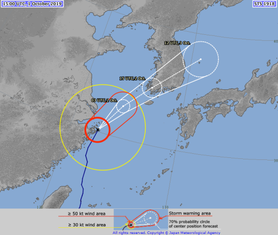


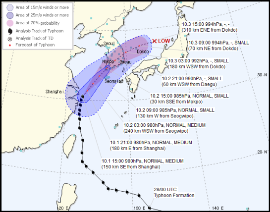


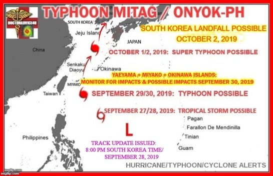


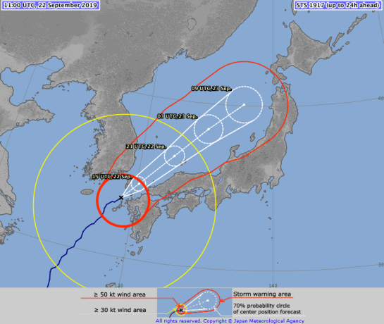

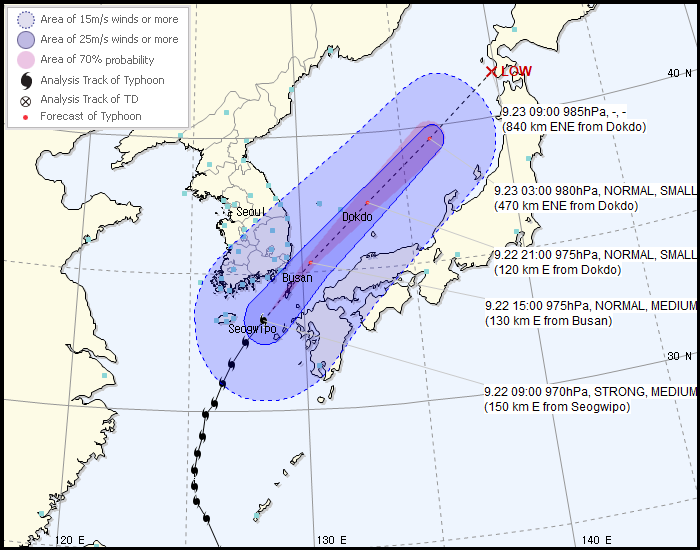


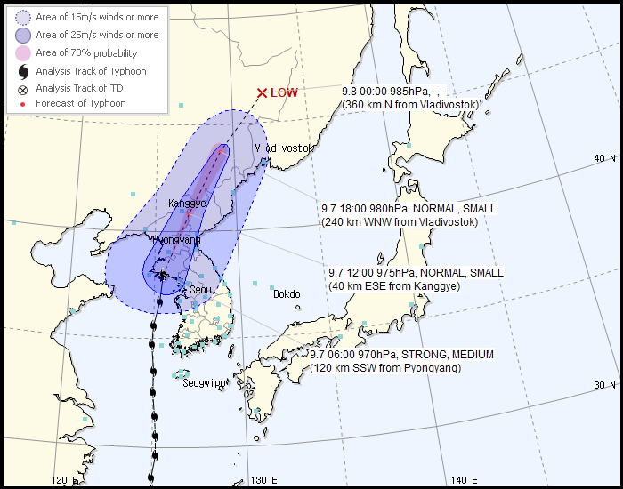


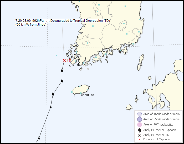


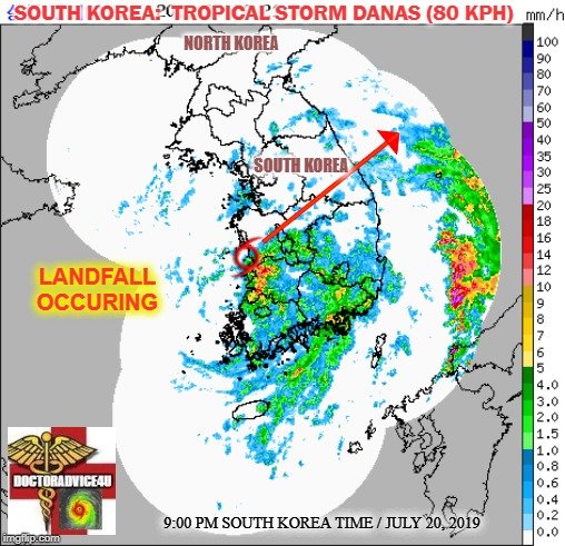


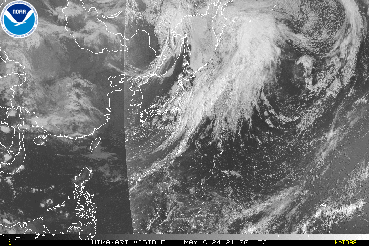


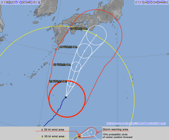


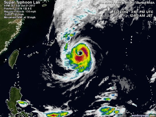


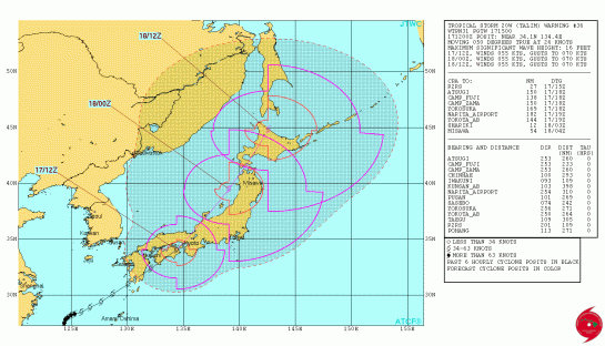
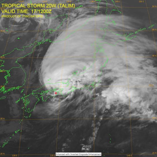
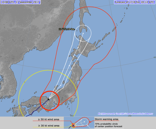
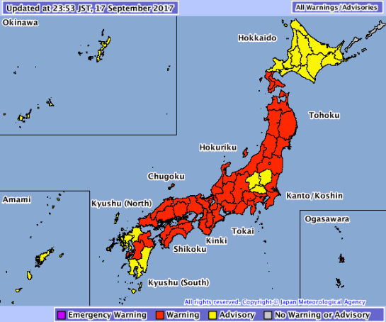
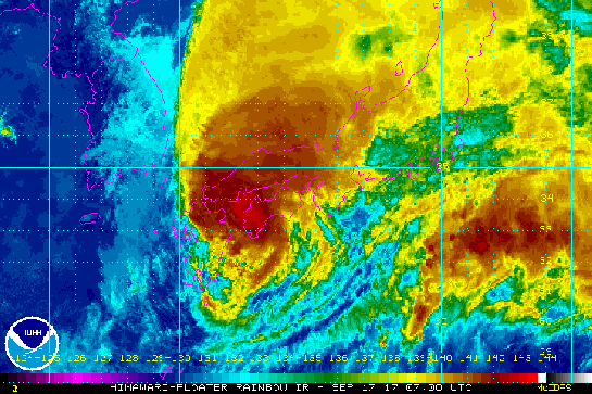
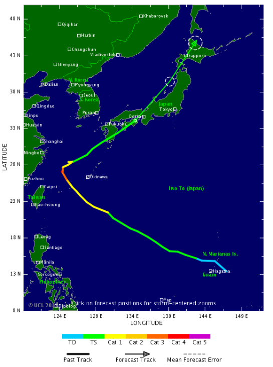
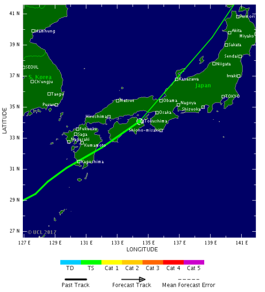
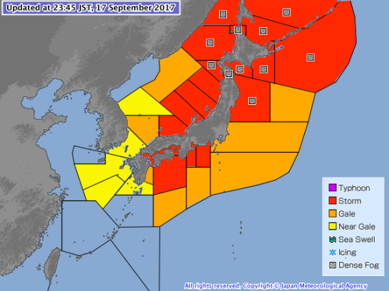
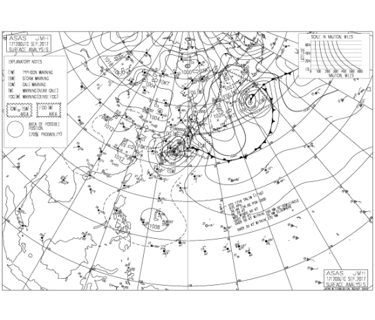


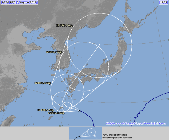


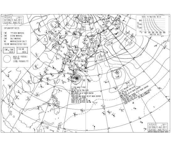


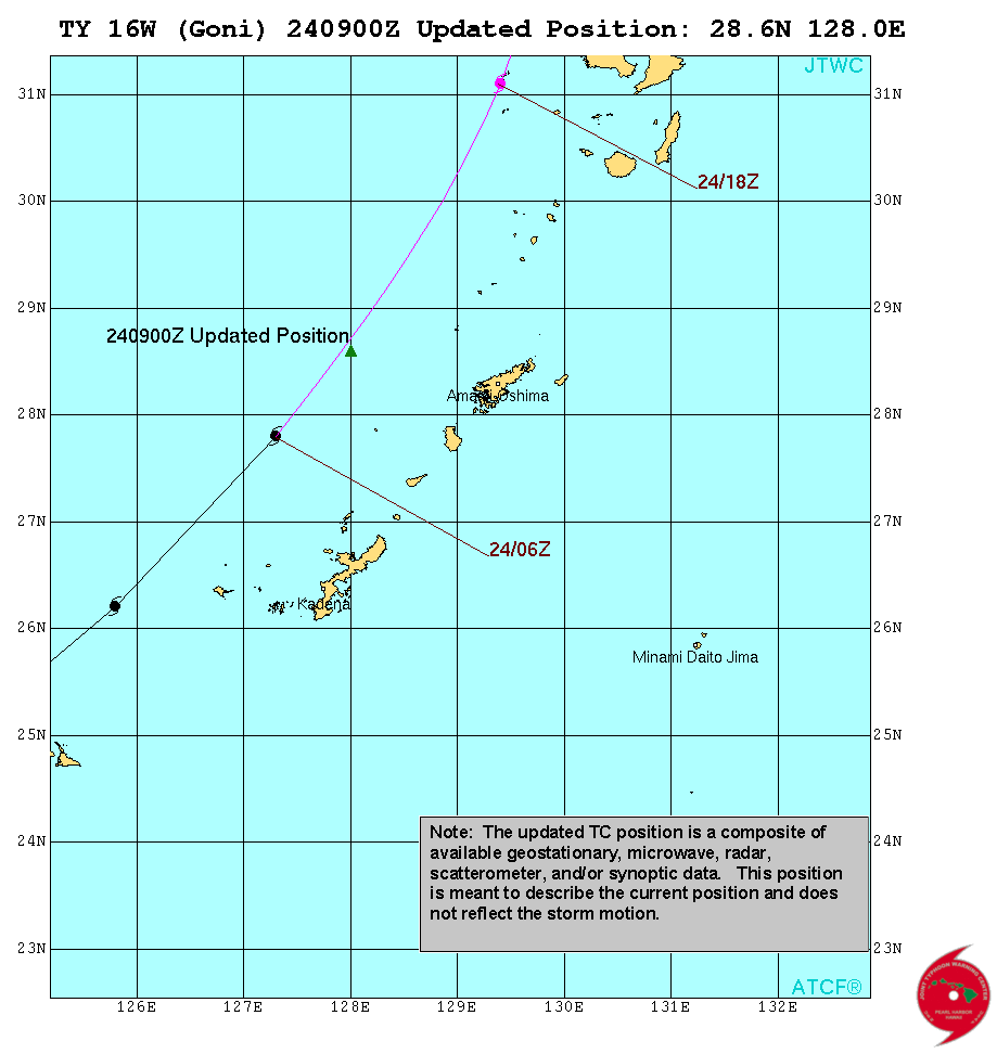


 Dost_pagasa


