Typhoon Tembin (33W)
(Vinta in Philippines)
TYPHOON “VINTA” IS NOW OUTSIDE THE PHILIPPINE AREA OF RESPONSIBILITY (PAR). – PAGASA
![]()

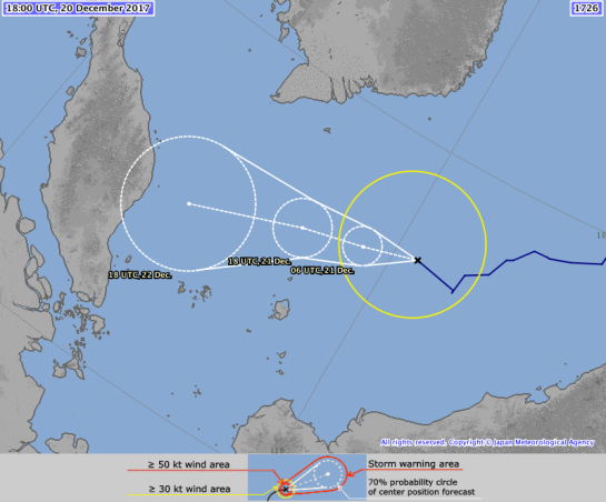
TY 1727 (Tembin)
Issued at 12:45 UTC, 24 December 2017
| <Analysis at 12 UTC, 24 December> | |
| Scale | – |
| Intensity | Strong |
| Center position | N8°20′ (8.3°) |
| E112°05′ (112.1°) | |
| Direction and speed of movement | W 25 km/h (13 kt) |
| Central pressure | 975 hPa |
| Maximum wind speed near center | 35 m/s (70 kt) |
| Maximum wind gust speed | 50 m/s (100 kt) |
| ≥ 50 kt wind area | ALL 70 km (40 NM) |
| ≥ 30 kt wind area | NW 390 km (210 NM) |
| SE 220 km (120 NM) | |
| <Forecast for 00 UTC, 25 December> | |
| Intensity | Strong |
| Center position of probability circle | N8°25′ (8.4°) |
| E109°25′ (109.4°) | |
| Direction and speed of movement | W 25 km/h (13 kt) |
| Central pressure | 975 hPa |
| Maximum wind speed near center | 35 m/s (70 kt) |
| Maximum wind gust speed | 50 m/s (100 kt) |
| Radius of probability circle | 70 km (40 NM) |
| Storm warning area | ALL 150 km (80 NM) |
| <Forecast for 12 UTC, 25 December> | |
| Intensity | – |
| Center position of probability circle | N8°30′ (8.5°) |
| E106°55′ (106.9°) | |
| Direction and speed of movement | W 20 km/h (12 kt) |
| Central pressure | 990 hPa |
| Maximum wind speed near center | 30 m/s (55 kt) |
| Maximum wind gust speed | 40 m/s (80 kt) |
| Radius of probability circle | 110 km (60 NM) |
| Storm warning area | ALL 180 km (95 NM) |
| <Forecast for 12 UTC, 26 December> | |
| Intensity | – |
| TD | |
| Center position of probability circle | N9°25′ (9.4°) |
| E102°55′ (102.9°) | |
| Direction and speed of movement | W 20 km/h (10 kt) |
| Central pressure | 1004 hPa |
| Radius of probability circle | 180 km (95 NM) |
Philippines
SEVERE WEATHER BULLETIN #29-FINAL
FOR:Typhoon Vinta
Tropical Cyclone: ALERT
ISSUED AT:10:30 AM, 24 December 2017
TYPHOON “VINTA” IS NOW OUTSIDE THE PHILIPPINE AREA OF RESPONSIBILITY (PAR).
- Scattered to widespread moderate to occasionally heavy rains will still prevail over Palawan, especially over the southern section. Residents of these areas must take appropriate actions against flooding and landslides, coordinate with their respective local disaster risk reduction and management offices, and continue monitoring for updates.
- Sea travel remains risky over the western seaboard of Palawan due to the Typhoon.
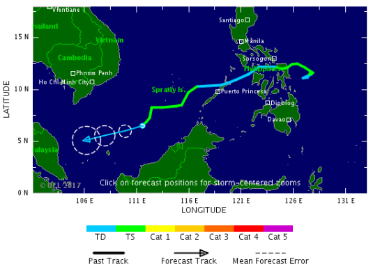
PAGASA Track  |
Satellite Image |
| Location of eye/center: | At 9:30 AM today, the eye of Typhoon “VINTA” was located based on all available data at 290 km South of Pagasa Island, Palawan (OUTSIDE PAR) (08.4 °N, 114.2 °E) |
| Strength: | Maximum sustained winds of 120 kph near the center and gustiness of up to 145 kph |
| Forecast Movement: | Forecast to move West at 26 kph |
| Forecast Positions: |
|
| NO TROPICAL CYCLONE WARNING SIGNAL |
With this development and unless re-entry occurs, this is the final bulletin for this weather disturbance.
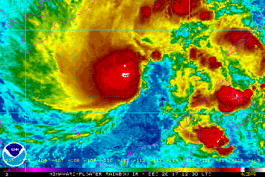
HIMAWARI Imagery

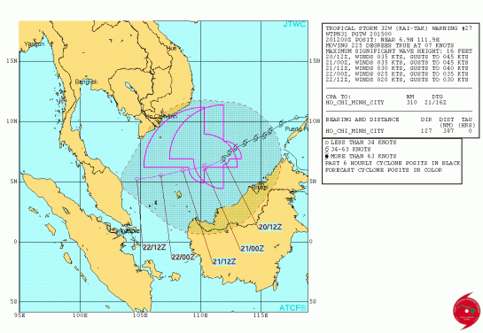
TROPICAL STORM RISK (TSR)
NW Pacific: Storm Alert issued at 24 Dec, 2017 6:00 GMT
Typhoon TEMBIN is currently located near 8.3 N 113.2 E with maximum 1-min sustained winds of 80 kts (92 mph). TEMBIN is a category 1 storm on the Saffir Simpson Hurricane Wind Scale. TEMBIN is forecast to affect land to the following likelihood(s) at the given lead time(s):
Red Alert Country(s) or Province(s)
Vietnam
probability for CAT 1 or above is 50% in about 24 hours
probability for TS is 95% within 12 hours
Red Alert City(s) and Town(s)
Bac Lieu (9.3 N, 105.7 E)
probability for CAT 1 or above is 40% in about 36 hours
probability for TS is 70% in about 36 hours
Yellow Alert Country(s) or Province(s)
Cambodia
probability for CAT 1 or above is 15% in about 36 hours
probability for TS is 70% in about 24 hours
Yellow Alert City(s) and Town(s)
Phan Thiet (10.9 N, 108.1 E)
probability for CAT 1 or above is 10% in about 24 hours
probability for TS is 95% in about 24 hours
Phan Rang (11.6 N, 109.0 E)
probability for TS is 90% within 12 hours
Ho Chi Minh City (10.8 N, 106.7 E)
probability for CAT 1 or above is 15% in about 36 hours
probability for TS is 80% in about 24 hours
Nha Trang (12.2 N, 109.2 E)
probability for TS is 75% in about 24 hours
Can Tho (10.0 N, 105.8 E)
probability for CAT 1 or above is 20% in about 36 hours
probability for TS is 70% in about 24 hours
Nam Can (8.8 N, 105.0 E)
probability for CAT 1 or above is 20% in about 36 hours
probability for TS is 55% in about 36 hours
Duong Dong (10.2 N, 104.0 E)
probability for CAT 1 or above is 15% in about 36 hours
probability for TS is 50% in about 36 hours
Kompong Som (10.6 N, 103.7 E)
probability for CAT 1 or above is 10% in about 36 hours
probability for TS is 45% in about 36 hours
Green Alert City(s) and Town(s)
Phnom Penh (11.6 N, 104.8 E)
probability for TS is 45% in about 36 hours
Tuy Hoa (13.1 N, 109.3 E)
probability for TS is 35% in about 24 hours
Kracheh (12.5 N, 106.0 E)
probability for TS is 35% in about 36 hours
Kas Kong (11.3 N, 103.2 E)
probability for TS is 35% in about 48 hours
Note that
Red Alert (Severe) is CAT 1 or above to between 31% and 100% probability.
Yellow Alert (Elevated) is CAT 1 or above to between 10% and 30% probability, or TS to above 50% probability.
Green Alert (Low) is TS to between 31% and 50% probability.
CAT 1 means Typhoon strength winds of at least 74 mph, 119 km/h or 64 knots 1-min sustained.
TS means Tropical Storm strength winds of at least 39 mph, 63 km/h or 34 knots 1-min sustained.
For graphical forecast information and further details please visit http://www.tropicalstormrisk.com/


Other

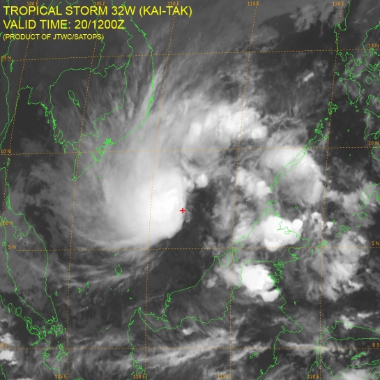
(Above image: @wunderground)
Tropical Storm Tembin: Philippines rescuers seek victims

The Salvador district is among those badly affected – REUTERS
“Rescuers are searching for victims of a tropical storm in the southern Philippines which has killed some 200 people in mudslides and flash floods.
Rescue teams have yet to reach some of the affected areas on Mindanao island.
About 150 people are still missing after Storm Tembin swept through the region, with another 70,000 displaced from their homes.
The rescue effort is being hampered by continuing heavy rain, power cuts and blocked roads.
In the early hours of Sunday, Tembin, known as Vinta in the Philippines, was south of the Spratly Islands, heading towards southern Vietnam. It had gathered strength, with maximum winds of 120km/h (75 mph).
United Nations Secretary General Antonio Guterres said he was saddened by the loss of life, adding that the UN was ready to help.
There are fears the death toll will rise further.
Philippine President Rodrigo Duterte is due to visit communities affected by Storm Tembin on Sunday.
Police said 135 people had been killed and 72 were missing in northern Mindanao. Forty-seven were killed and 72 missing in the Zamboanga peninsula. In Lanao del Sur, another 18 died.
Between 40,000 and 60,000 people are reported to be housed in evacuation centres.
The mountain village of Dalama was one of the worst affected places. Houses were buried in mud or engulfed in floodwaters.
“The flood was already close and the people were not able to get out from their homes,” survivor Armando Sangcopan told local TV.
The bodies of eight children were extracted from thick mud in the town of Salvador in Lanao del Norte, the Inquirer reports.
“It’s very painful to see the dead bodies of children, whom we also considered to be our own,” the principal, Ricardo Abalo, told the paper.
Aid workers said people had not heeded warnings to evacuate before Tembin arrived, either because they believed the storm would not be severe or they had nowhere else to go.
Risks of disease
Many victims were swept away from low-lying residential areas when the flash floods and landslides struck.
More deaths were reported in Bukidnon, Iligan and Misamis Occidental.
Andrew Morris, from the UN children’s agency Unicef in Mindanao, said in some areas there were big risks of disease, particularly for children, and restoring clean water supplies would be a priority.
“Lanao del Sur province is the poorest in the Philippines, and in the past seven months there have been around 350,000 people displaced in that province because of fighting,” he told the BBC, referring to battles between government forces and Islamist militants in Marawi.
Meanwhile, Richard Gordon, of the Philippines Red Cross, told the BBC: “We have already provided water and hot food.
“And we’re going to be distributing non-food items – certainly blankets, mosquito nets and certainly hygiene kits for those who are in evacuation centres so that we can alleviate the suffering of many of the folks there.
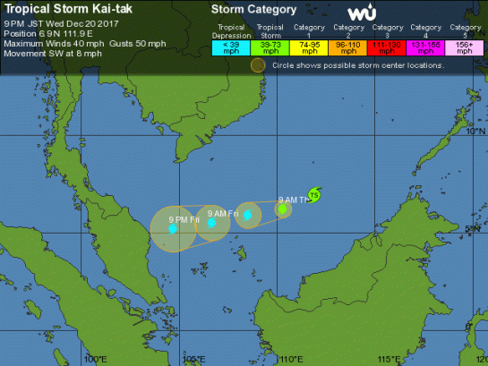
A week ago, Tropical Storm Kai-Tak hit the central Philippines, killing dozens.
The region is still recovering from Typhoon Haiyan, which killed more than 5,000 people and affected millions in 2013.” – BBC News

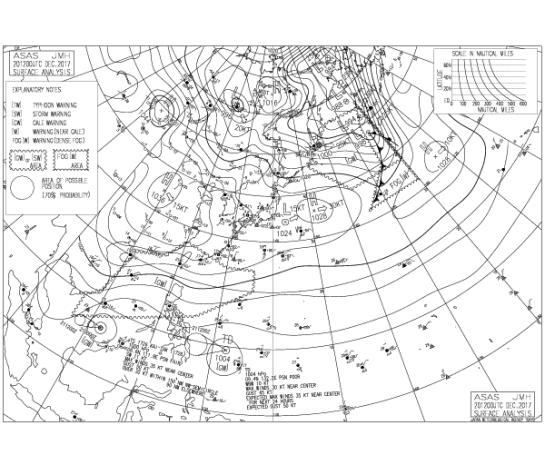
MARITIME/SHIPPING
![]()

METAREA11 / TYPHOON_WARNING_JAPAN / 231200
WTJP22 RJTD 241200
WARNING 241200.
WARNING VALID 251200.
WARNING IS UPDATED EVERY 6 HOURS.
TYPHOON WARNING.
TYPHOON 1727 TEMBIN (1727) 975 HPA
AT 08.3N 112.1E SOUTH CHINA SEA MOVING WEST 13 KNOTS.
POSITION FAIR.
MAX WINDS 70 KNOTS NEAR CENTER.
RADIUS OF OVER 50 KNOT WINDS 40 MILES.
RADIUS OF OVER 30 KNOT WINDS 210 MILES NORTHWEST SEMICIRCLE AND 120
MILES ELSEWHERE.
FORECAST POSITION FOR 250000UTC AT 08.4N 109.4E WITH 40 MILES RADIUS
OF 70 PERCENT PROBABILITY CIRCLE.
975 HPA, MAX WINDS 70 KNOTS NEAR CENTER.
FORECAST POSITION FOR 251200UTC AT 08.5N 106.9E WITH 60 MILES RADIUS
OF 70 PERCENT PROBABILITY CIRCLE.
990 HPA, MAX WINDS 55 KNOTS NEAR CENTER.
EXTENDED OUTLOOK.
FORECAST POSITION FOR 261200UTC AT 09.4N 102.9E WITH 95 MILES RADIUS
OF 70 PERCENT PROBABILITY CIRCLE.
1004 HPA.
BECOMING TROPICAL DEPRESSION.
JAPAN METEOROLOGICAL AGENCY.=
Philippines
As of today, there is no Tropical Cyclone within Philippine Area of Responsibility (PAR).
PAGASA
=============================================================================
Do not use any information on this site for life or death decisions. All information is intended as supplementary to official sources. Kindly refer to your country’s official weather agency/government website for local warnings, advisories and bulletins.