Typhoon MARIA 10W
MARIA is a category 3 storm on the Saffir Simpson Hurricane Wind Scale.
Ryukyu Islands (esp Miyako and Yaeyama Islands)/ Okinawa/ Amami Islands/ Taiwan/ China BEWARE!
MAXIMUM SIGNIFICANT WAVE HEIGHT AT 101200Z IS 28 FEET- JTWC
JOINT TYPHOON WARNING CENTER
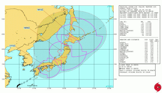
Typhoon 10W (Maria) Warning #32
Issued at 10/1500Z


Google Earth Overlay 
WTPN32 PGTW 101500
MSGID/GENADMIN/JOINT TYPHOON WRNCEN PEARL HARBOR HI//
SUBJ/TROPICAL CYCLONE WARNING//
RMKS/
1. TYPHOON 10W (MARIA) WARNING NR 032
01 ACTIVE TROPICAL CYCLONE IN NORTHWESTPAC
MAX SUSTAINED WINDS BASED ON ONE-MINUTE AVERAGE
WIND RADII VALID OVER OPEN WATER ONLY
—
WARNING POSITION:
101200Z — NEAR 25.2N 124.1E
MOVEMENT PAST SIX HOURS – 295 DEGREES AT 15 KTS
POSITION ACCURATE TO WITHIN 010 NM
POSITION BASED ON EYE FIXED BY A COMBINATION OF
SATELLITE AND RADAR
PRESENT WIND DISTRIBUTION:
MAX SUSTAINED WINDS – 105 KT, GUSTS 130 KT
WIND RADII VALID OVER OPEN WATER ONLY
RADIUS OF 064 KT WINDS – 050 NM NORTHEAST QUADRANT
035 NM SOUTHEAST QUADRANT
040 NM SOUTHWEST QUADRANT
040 NM NORTHWEST QUADRANT
RADIUS OF 050 KT WINDS – 100 NM NORTHEAST QUADRANT
090 NM SOUTHEAST QUADRANT
080 NM SOUTHWEST QUADRANT
090 NM NORTHWEST QUADRANT
RADIUS OF 034 KT WINDS – 190 NM NORTHEAST QUADRANT
170 NM SOUTHEAST QUADRANT
145 NM SOUTHWEST QUADRANT
170 NM NORTHWEST QUADRANT
REPEAT POSIT: 25.2N 124.1E
—
FORECASTS:
12 HRS, VALID AT:
110000Z — 26.3N 120.6E
MAX SUSTAINED WINDS – 090 KT, GUSTS 110 KT
WIND RADII VALID OVER OPEN WATER ONLY
RADIUS OF 064 KT WINDS – 040 NM NORTHEAST QUADRANT
030 NM SOUTHEAST QUADRANT
035 NM SOUTHWEST QUADRANT
030 NM NORTHWEST QUADRANT
RADIUS OF 050 KT WINDS – 090 NM NORTHEAST QUADRANT
075 NM SOUTHEAST QUADRANT
065 NM SOUTHWEST QUADRANT
075 NM NORTHWEST QUADRANT
RADIUS OF 034 KT WINDS – 170 NM NORTHEAST QUADRANT
145 NM SOUTHEAST QUADRANT
120 NM SOUTHWEST QUADRANT
135 NM NORTHWEST QUADRANT
VECTOR TO 24 HR POSIT: 295 DEG/ 15 KTS
—
24 HRS, VALID AT:
111200Z — 27.5N 117.4E
MAX SUSTAINED WINDS – 055 KT, GUSTS 070 KT
WIND RADII VALID OVER OPEN WATER ONLY
RADIUS OF 034 KT WINDS – 120 NM NORTHEAST QUADRANT
105 NM SOUTHEAST QUADRANT
065 NM SOUTHWEST QUADRANT
080 NM NORTHWEST QUADRANT
VECTOR TO 36 HR POSIT: 305 DEG/ 13 KTS
—
36 HRS, VALID AT:
120000Z — 29.0N 115.0E
MAX SUSTAINED WINDS – 035 KT, GUSTS 045 KT
WIND RADII VALID OVER OPEN WATER ONLY
DISSIPATING AS A SIGNIFICANT TROPICAL CYCLONE OVER LAND
VECTOR TO 48 HR POSIT: 310 DEG/ 10 KTS
—
EXTENDED OUTLOOK:
48 HRS, VALID AT:
121200Z — 30.4N 113.2E
MAX SUSTAINED WINDS – 020 KT, GUSTS 030 KT
WIND RADII VALID OVER OPEN WATER ONLY
DISSIPATED AS A SIGNIFICANT TROPICAL CYCLONE OVER LAND
—
REMARKS:
101500Z POSITION NEAR 25.5N 123.2E.
TYPHOON 10W (MARIA), LOCATED APPROXIMATELY 141 NM EAST OF TAIPEI,
TAIWAN, HAS TRACKED WEST-NORTHWESTWARD AT 15 KNOTS OVER THE PAST
SIX HOURS. MAXIMUM SIGNIFICANT WAVE HEIGHT AT 101200Z IS 28 FEET.
NEXT WARNINGS AT 102100Z, 110300Z, 110900Z AND 111500Z.//
NNNN
![]()
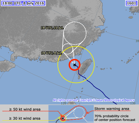
(JMA is the lead agency in this area)


TY 1808 (Maria)
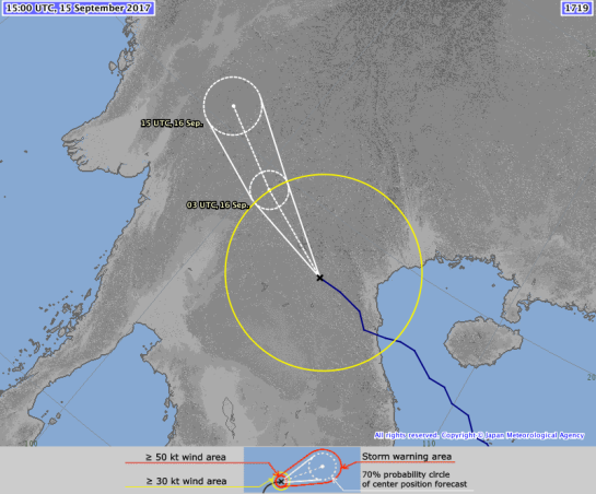
Issued at 13:45 UTC, 10 July 2018
| <Analysis at 13 UTC, 10 July> | |
| Scale | – |
| Intensity | Very strong |
| Center position | N25°25′ (25.4°) |
| E123°50′ (123.8°) | |
| Direction and speed of movement | WNW 30 km/h (15 kt) |
| Central pressure | 940 hPa |
| Maximum wind speed near center | 50 m/s (95 kt) |
| Maximum wind gust speed | 70 m/s (135 kt) |
| ≥ 50 kt wind area | E 240 km (130 NM) |
| W 150 km (80 NM) | |
| ≥ 30 kt wind area | E 500 km (270 NM) |
| W 280 km (150 NM) | |
| <Estimate for 14 UTC, 10 July> | |
| Scale | – |
| Intensity | Very strong |
| Center position | N25°30′ (25.5°) |
| E123°30′ (123.5°) | |
| Direction and speed of movement | WNW 30 km/h (15 kt) |
| Central pressure | 940 hPa |
| Maximum wind speed near center | 50 m/s (95 kt) |
| Maximum wind gust speed | 70 m/s (135 kt) |
| ≥ 50 kt wind area | E 240 km (130 NM) |
| W 150 km (80 NM) | |
| ≥ 30 kt wind area | E 500 km (270 NM) |
| W 280 km (150 NM) | |
| <Forecast for 00 UTC, 11 July> | |
| Intensity | Very strong |
| Center position of probability circle | N26°20′ (26.3°) |
| E120°30′ (120.5°) | |
| Direction and speed of movement | WNW 30 km/h (17 kt) |
| Central pressure | 955 hPa |
| Maximum wind speed near center | 45 m/s (85 kt) |
| Maximum wind gust speed | 60 m/s (120 kt) |
| Radius of probability circle | 70 km (40 NM) |
| Storm warning area | E 300 km (160 NM) |
| W 220 km (120 NM) | |
| <Forecast for 12 UTC, 11 July> | |
| Intensity | – |
| Center position of probability circle | N27°10′ (27.2°) |
| E116°55′ (116.9°) | |
| Direction and speed of movement | WNW 30 km/h (17 kt) |
| Central pressure | 990 hPa |
| Maximum sustained wind speed | 23 m/s (45 kt) |
| Maximum wind gust speed | 35 m/s (65 kt) |
| Radius of probability circle | 110 km (60 NM) |
| <Forecast for 12 UTC, 12 July> | |
| Intensity | – |
| TD | |
| Center position of probability circle | N30°50′ (30.8°) |
| E113°00′ (113.0°) | |
| Direction and speed of movement | NW 20 km/h (12 kt) |
| Central pressure | 1000 hPa |
| Radius of probability circle | 200 km (110 NM) |
CHINA

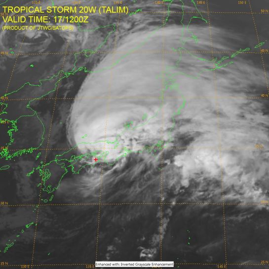
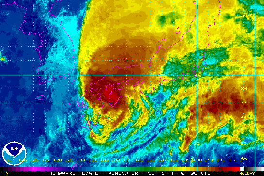
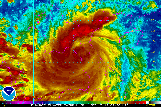
HIMAWARI Imagery

Tropical Storm Risk (TSR)
NW Pacific: Storm Alert issued at 10 Jul, 2018 6:00 GMT
Typhoon MARIA is currently located near 24.6 N 125.6 E with maximum 1-min sustained winds of 110 kts (127 mph). MARIA is a category 3 storm on the Saffir Simpson Hurricane Wind Scale. MARIA is forecast to affect land to the following likelihood(s) at the given lead time(s):
Red Alert Country(s) or Province(s)
Taiwan
probability for CAT 1 or above is 95% within 12 hours
probability for TS is 100% within 12 hours
China
probability for CAT 1 or above is 90% in about 24 hours
probability for TS is 95% in about 24 hours
Red Alert City(s) and Town(s)
Fu’an (27.1 N, 119.7 E)
probability for CAT 1 or above is 80% in about 24 hours
probability for TS is 95% in about 24 hours
Taipei (25.0 N, 121.5 E)
probability for CAT 1 or above is 75% within 12 hours
probability for TS is 100% within 12 hours
Wenzhou (27.5 N, 120.5 E)
probability for CAT 1 or above is 75% in about 24 hours
probability for TS is 95% in about 24 hours
Fuzhou (26.1 N, 119.3 E)
probability for CAT 1 or above is 75% in about 24 hours
probability for TS is 95% in about 24 hours
Putian (25.6 N, 119.0 E)
probability for CAT 1 or above is 45% in about 24 hours
probability for TS is 90% in about 24 hours
Yellow Alert City(s) and Town(s)
Okinawa (26.3 N, 127.8 E)
probability for TS is 95% currently
Wenling (28.4 N, 121.4 E)
probability for TS is 95% in about 24 hours
T’aichung (24.1 N, 120.7 E)
probability for TS is 85% in about 24 hours
Jinhua (29.2 N, 120.0 E)
probability for TS is 75% in about 36 hours
Quzhou (29.0 N, 119.0 E)
probability for CAT 1 or above is 10% in about 36 hours
probability for TS is 75% in about 24 hours
Quanzhou (25.0 N, 118.5 E)
probability for TS is 65% in about 24 hours
Nanchang (28.7 N, 115.9 E)
probability for CAT 1 or above is 15% in about 36 hours
probability for TS is 60% in about 36 hours
Green Alert City(s) and Town(s)
Ningbo (29.7 N, 121.5 E)
probability for TS is 50% in about 24 hours
Hangzhou (30.3 N, 120.2 E)
probability for TS is 35% in about 24 hours
Zhangzhou (24.5 N, 117.8 E)
probability for TS is 35% in about 24 hours
Wuhan (30.6 N, 114.3 E)
probability for TS is 35% in about 48 hours
Note that
Red Alert (Severe) is CAT 1 or above to between 31% and 100% probability.
Yellow Alert (Elevated) is CAT 1 or above to between 10% and 30% probability, or TS to above 50% probability.
Green Alert (Low) is TS to between 31% and 50% probability.
CAT 1 means Typhoon strength winds of at least 74 mph, 119 km/h or 64 knots 1-min sustained.
TS means Tropical Storm strength winds of at least 39 mph, 63 km/h or 34 knots 1-min sustained.
For graphical forecast information and further details please visit http://www.tropicalstormrisk.com/


Current probability of tropical storm wind:

Current probability of Cat 1 or above wind:

Other

(Image: @RoshinRowjee)
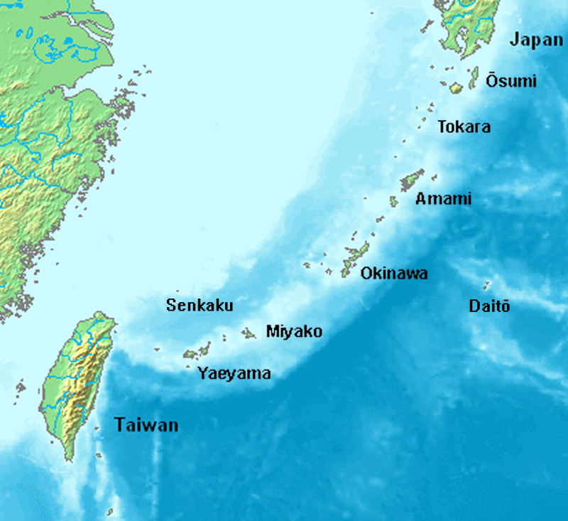
Location of Ryukyu Islands( 📷 Uchinanchu/wikimedia)
MARITIME/SHIPPING

WTJP22 RJTD 101200
WARNING 101200.
WARNING VALID 111200.
WARNING IS UPDATED EVERY 6 HOURS.
TYPHOON WARNING.
TYPHOON 1808 MARIA (1808) 940 HPA
AT 25.2N 124.1E EAST CHINA SEA MOVING WESTNORTHWEST 15 KNOTS.
POSITION GOOD.
MAX WINDS 95 KNOTS NEAR CENTER.
RADIUS OF OVER 50 KNOT WINDS 130 MILES EAST SEMICIRCLE AND 80 MILES
ELSEWHERE.
RADIUS OF OVER 30 KNOT WINDS 270 MILES EAST SEMICIRCLE AND 150 MILES
ELSEWHERE.
FORECAST POSITION FOR 110000UTC AT 26.3N 120.5E WITH 40 MILES RADIUS
OF 70 PERCENT PROBABILITY CIRCLE.
955 HPA, MAX WINDS 85 KNOTS NEAR CENTER.
FORECAST POSITION FOR 111200UTC AT 27.2N 116.9E WITH 60 MILES RADIUS
OF 70 PERCENT PROBABILITY CIRCLE.
990 HPA, MAX WINDS 45 KNOTS.
EXTENDED OUTLOOK.
FORECAST POSITION FOR 121200UTC AT 30.8N 113.0E WITH 110 MILES RADIUS
OF 70 PERCENT PROBABILITY CIRCLE.
1000 HPA.
BECOMING TROPICAL DEPRESSION.
JAPAN METEOROLOGICAL AGENCY.=
WWHK82 VHHH 101200
40:1:31:11:01:00
HONG KONG METEOROLOGICAL SERVICE PROVIDES THE FOLLOWING
WARNING/INFORMATION FOR THE SOUTH CHINA SEA.
WARNINGS
SEVERE TYPHOON (ST) MARIA (1808):
R OF HURRICANES:60NM.
R OF STORMS:120NM.
R OF GALES:210NM.
SYNOPSIS (101200UTC) AND 24-HOUR FORECAST
SUPER TYPHOON MARIA (1808) HAS WEAKENED INTO A ST. AT
101200UTC, MARIA WITH CENTRAL P 955HPA AND MAX WINDS 90KT
WAS CENTERED WITHIN 30NM OF 25.2N 124.0E AND IS FC TO MOVE
WNW AT ABOUT 16KT FOR THE NEXT 24 HOURS.
FC POS AT 111200UTC: 27.3N, 116.7E
SIGNIFICANT SWELL/HIGH SEAS
SEAS 6M,10M,14M OVER GALES,STORMS,HURRICANES.
SWELL E TO NE 5-7M OVER SEAS NEAR TAIWAN AND LUZON STRAIT.
SWELL SE 5-7M OVER EAST CHINA SEA.
THUNDERSTORMS/SEVERE WEATHER
FRQ HEAVY SQ SH AND TS WITHIN 240 NM FROM CENTRE OF MARIA
(1808).
SCT SQ SH AND TS OVER SEAS NEAR THE PHILIPPINES, SEAS NEAR
MALAYSIA.
ISOL SQ SH AND TS OVER N PART OF SCS, GULF OF THAILAND AND
GULF OF TONKIN.
SEA FOG/REDUCED VISIBILITY
VIS 500 M IN SQ SH AND TS.
WWCI50 BABJ 100600
2:31:11:11:00
BT
PAN PAN=
MESSAGE FOR NAVAREA XI(IOR) ISSUED BY NMC BEIJING
AT 1015UTC JUL.10 2018=
MESSAGE IS UPDATED EVERY 06 HOURS=
SYNOPSIS VALID 0600UTC JUL.10=
FCST VALID 0600UTC JUL.11=
WARNNING=
TROPICAL CYCLONE WARNNING=
SUPERTY MARIA 1808(1808) 935HPA AT 24.7N 125.6E
MVG WNW 30KMH AND MAX WINDS 52M/S NEAR CENTER
(SEAS UP TO 12.0M)
AND RADIUS OF 30KTS WINDS
550KM NE
450KM SE
270KM SW
350KM NW
AND RADIUS OF 50KTS WINDS
200KM NE
150KM SE
100KM SW
150KM NW
AND RADIUS OF 64KTS WINDS
70KM NE
50KM SE
40KM SW
70KM NW
AND FCST FOR 110600UTC AT 26.7N 118.6E 982HPA
AND MAX WINDS 28M/S NEAR CENTER=SUMMARY=
SE WINDS FROM 08 TO 16M/S GUSTS 18M/S SEAS UP TO
2.0M OVER SEA SOUTH OF JAPAN=
SW WINDS FROM 08 TO 16M/S GUSTS 18M/S SEAS UP TO
2.0M OVER SOUTHERN PART OF SOUTH CHINA SEA=
WINDS FROM 22 TO 32M/S SEAS UP TO 6.0M
OVER SOUTHEASTERN PART OF EAST CHINA SEA
AND SEA EAST OF TAIWAN
AND SEA EAST OF RYUKYU ISLANDS=
CYCLONIC WINDS FROM 33 TO 50M/S SEAS UP TO 10.0M
OVER SEA NEAR CENTRAL OF MARIA=
HORIZONTAL VISIBILITY LESS THAN 10KM OVER YELLOW
SEA AND KOREA STRAIT AND NORTHEASTERN PART OF
JAPAN SEA AND SEA EAST OF RYUKYU ISLANDS AND
ANDAMAN SEA AND SEA WEST OF SUMATERA AND
SEA EAST OF SINGAPORE AND SUNDA STRAIT AND
MAKASSAR STRAIT AND LAUT SULAWESI AND LAUT BANDA=
FCST=
NORTHERN PART OF YELLOW SEA
S WINDS 12 TO 15M/S GUSTS 14 TO 18M/S DECR 07 TO
10M/S GUSTS 08 TO 12M/S SEA STATE MOD TO SLT
RAINSTORM BECMG DOWNPOUR VIS MOD TO POOR=
CENTRAL PART OF YELLOW SEA
S WINDS 08 TO 12M/S GUSTS 12 TO 15M/S DECR 07 TO
10M/S GUSTS 08 TO 12M/S SEA STATE SLT MOD RAIN
BECMG LIGHT RAIN VIS MOD TO GOOD=
NORTHERN PART OF EAST CHINA SEA
E WINDS VEER SE 12 TO 15M/S GUSTS 14 TO 18M/S SEA
STATE MOD LIGHT RAIN BECMG MOD RAIN VIS GOOD=
SOUTHERN PART OF EAST CHINA SEA
CYCLONIC WINDS 29 TO 36M/S GUSTS 32 TO 41M/S SEA
STATE VERY ROUGH DOWNPOUR VIS POOR=
TAIWAN STRAIT
N WINDS 08 TO 12M/S GUSTS 12 TO 15M/S BACK SW
WINDS 14 TO 18M/S GUSTS 18 TO 24M/S SEA STATE MOD
HVY RAIN BECMG DOWNPOUR VIS GOOD TO MOD=
SEA EAST OF TAIWAN
CYCLONIC WINDS 25 TO 32M/S GUSTS 29 TO 36M/S BECMG
S WINDS 18 TO 24M/S GUSTS 22 TO 28M/S SEA STATE
VERY ROUGH DOWNPOUR VIS POOR TO MOD=
BASHI CHANNEL
SW WINDS 08 TO 12M/S GUSTS 12 TO 15M/S SEA STATE
MOD LIGHT RAIN BECMG MOD RAIN VIS GOOD=
QIONGZHOU STRAIT
E WINDS 08 TO 12M/S GUSTS 12 TO 15M/S DECR 07 TO
10M/S GUSTS 08 TO 12M/S SEA STATE SLT TO SMOOTH
MOD RAIN VIS MOD=
SOUTHWESTERN PART OF SOUTH CHINA SEA
SW WINDS 12 TO 15M/S GUSTS 14 TO 18M/S SEA STATE
MOD MOD RAIN BECMG HVY RAIN VIS MOD=
SOUTHEASTERN PART OF SOUTH CHINA SEA
SW WINDS 08 TO 12M/S GUSTS 12 TO 15M/S INCR 12 TO
15M/S GUSTS 14 TO 18M/S SEA STATE MOD HVY RAIN
VIS MOD=
SEA EAST OF RYUKYU ISLANDS
CYCLONIC WINDS 18 TO 24M/S GUSTS 22 TO 28M/S BECMG
SE WINDS 12 TO 15M/S GUSTS 14 TO 18M/S SEA STATE
ROUGH TO MOD DOWNPOUR BECMG MOD RAIN VIS MOD=
SEA NORTHEAST OF THE PHILIPPINES
S WINDS 08 TO 12M/S GUSTS 12 TO 15M/S BACK SE
WINDS 07 TO 10M/S GUSTS 08 TO 12M/S SEA STATE MOD
MOD RAIN BECMG HVY RAIN VIS MOD=
SEA WEST OF SUMATERA
SE WINDS 07 TO 10M/S GUSTS 08 TO 12M/S INCR 08 TO
12M/S GUSTS 12 TO 15M/S SEA STATE MOD DOWNPOUR
BECMG MOD RAIN VIS GOOD=
MALACCA STRAIT
W WINDS 08 TO 12M/S GUSTS 12 TO 15M/S DECR 07 TO
10M/S GUSTS 08 TO 12M/S SEA STATE SMOOTH MOD RAIN
VIS GOOD=
SEA SOUTH OF VIETNAM
W WINDS 08 TO 12M/S GUSTS 12 TO 15M/S SEA STATE
MOD HVY RAIN VIS MOD=
GULF OF THAILAND
W WINDS 08 TO 12M/S GUSTS 12 TO 15M/S SEA STATE
SLT HVY RAIN VIS MOD=
ANDAMAN SEA
W WINDS BACK SW 08 TO 12M/S GUSTS 12 TO 15M/S SEA
STATE MOD HVY RAIN BECMG RAINSTORM VIS MOD=
=============================================================================
Do not use any information on this site for life or death decisions. All information is intended as supplementary to official sources. Kindly refer to your country’s official weather agency/government website for local warnings, advisories and bulletins.


 will be displayed when the tropical cyclone is expected to weaken into a low pressure area or transform into an extratropical low.