“BUTCHOY” SLIGHTLY INTENSIFIES AS IT MOVES WEST-NORTHWESTWARD AWAY FROM LUZON (PAGASA)
The tropical cyclone now over the central part of the South China Sea is expected to intensify gradually, and will edge closer to the coast of western Guangdong in the next couple of days. (HKO)
TS 2002 (Nuri) Issued at 13:05 UTC, 12 June 2020
<Analysis at 12 UTC, 12 June>
Scale
–
Intensity
–
Center position
N16°50′ (16.8°)
E117°10′ (117.2°)
Direction and speed of movement
W 20 km/h (11 kt)
Central pressure
998 hPa
Maximum wind speed near center
18 m/s (35 kt)
Maximum wind gust speed
25 m/s (50 kt)
≥ 30 kt wind area
ALL 220 km (120 NM)
<Forecast for 00 UTC, 13 June>
Intensity
–
Center position of probability circle
N18°25′ (18.4°)
E115°25′ (115.4°)
Direction and speed of movement
NW 20 km/h (12 kt)
Central pressure
996 hPa
Maximum wind speed near center
20 m/s (40 kt)
Maximum wind gust speed
30 m/s (60 kt)
Radius of probability circle
65 km (35 NM)
<Forecast for 12 UTC, 13 June>
Intensity
–
Center position of probability circle
N20°00′ (20.0°)
E113°35′ (113.6°)
Direction and speed of movement
NW 20 km/h (12 kt)
Central pressure
992 hPa
Maximum wind speed near center
23 m/s (45 kt)
Maximum wind gust speed
35 m/s (65 kt)
Radius of probability circle
95 km (50 NM)
<Forecast for 12 UTC, 14 June>
Intensity
–
TD
Center position of probability circle
N23°30′ (23.5°)
E110°20′ (110.3°)
Direction and speed of movement
NW 20 km/h (12 kt)
Central pressure
1002 hPa
Radius of probability circle
165 km (90 NM)
Typhoon Message
20200612 20:56
National Meteorological Center No.1872
Analysis Time: Jun. 12th 12 UTC
Name of TC: NURI
Num. of TC: 2002
Current Location: 17.1°N 117.2°E
Max. 10-min Wind Speed: 18m/s(64.8km/h)
Central Pressure: 998hPa
Radius of 34knots Winds: NE 180km SE 150km SW 140km NW 120km
Forecast movement: next 24hrs NURI will moving NW at speed of 17km/h
xxxxx
Philippines
Tropical Depression”Butchoy”
Tropical Cyclone: ALERT
Issued at 11:00 am, 12 June 2020
(Valid for broadcast until the next advisory to be issued at 11:00 PM today or earlier.)
“BUTCHOY” SLIGHTLY INTENSIFIES AS IT MOVES WEST-NORTHWESTWARD AWAY FROM LUZON.
Tropical Depression BUTCHOY is forecast to intensify into a tropical storm within 24 hours. It is also expected to exit the Philippine Area of Responsibility (PAR) tonight or tomorrow morning and is forecast to move generally northwestward towards southern China.
All tropical cyclone wind signals have been lifted. However, occasional gusts associated with the Southwest Monsoon may still be experienced over most of Northern and Central Luzon and the western section of Southern Luzon and Visayas.
Heavy Rainfall Outlook
Today: Moderate to heavy rains over Zambales, Bataan, Pangasinan, the northern portion of Palawan including Calamian and Cuyo Islands, and Occidental Mindoro. Light to moderate with at times heavy monsoon rains over Metro Manila, Western Visayas, and the rest of Luzon.
Flooding and rain-induced landslides may occur during heavy or prolonged rainfall especially in areas that are highly or very highly susceptible to these hazards. The public and disaster risk reduction and management offices are advised to take appropriate measures and monitor the Rainfall or Thunderstorm Advisories or Heavy Rainfall Warnings of PAGASA Regional Services Divisions.
Coastal Water Conditions
In the next 24 hours, moderate to very rough seas (1.5 to 4.5 m) will be experienced over the seaboards of Northern and Central Luzon especially over the seaboards of Ilocos Region, Zambales and Bataan due to BUTCHOY and the Southwest Monsoon. Sea travel is risky especially for those using small seacrafts.
Location of Eye/center
At 10:00 AM today, the center of Tropical Depression “BUTCHOY” was estimated based on all available data at 140 km West Northwest of Iba, Zambales or 165 km West of Dagupan City, Pangasinan (15.9 °N, 118.8 °E )
Movement
Moving West Northwestward at 25 km/h
Strength
Maximum sustained winds of 55 km/h near the center and gustiness of up to 70 km/h
Forecast Position
24 Hour(Tomorrow morning): 390 km West of Sinait, Ilocos Sur (OUTSIDE PAR)(17.4°N, 116.7°E)
48 Hour(Sunday morning):915 km West of Extreme Northern Luzon (OUTSIDE PAR)(20.9°N, 113.2°E)
Wind Signal
No Tropical Cyclone Wind Signal
The public and the disaster risk reduction and management council concerned are advised to take appropriate actions and watch for the next update to be incorporated in the 4 PM Public Weather Forecast and in the next Severe Weather Bulletin to be issued at 11 PM today.
WTJP21 RJTD 121200 WARNING 121200. WARNING VALID 131200. WARNING IS UPDATED EVERY 6 HOURS. GALE WARNING. TROPICAL STORM 2002 NURI (2002) UPGRADED FROM TROPICAL DEPRESSION 998 HPA AT 16.8N 117.2E SOUTH CHINA SEA MOVING WEST 11 KNOTS. POSITION POOR. MAX WINDS 35 KNOTS NEAR CENTER. RADIUS OF OVER 30 KNOT WINDS 120 MILES. FORECAST POSITION FOR 130000UTC AT 18.4N 115.4E WITH 35 MILES RADIUS OF 70 PERCENT PROBABILITY CIRCLE. 996 HPA, MAX WINDS 40 KNOTS NEAR CENTER. FORECAST POSITION FOR 131200UTC AT 20.0N 113.6E WITH 50 MILES RADIUS OF 70 PERCENT PROBABILITY CIRCLE. 992 HPA, MAX WINDS 45 KNOTS NEAR CENTER. EXTENDED OUTLOOK. FORECAST POSITION FOR 141200UTC AT 23.5N 110.3E WITH 90 MILES RADIUS OF 70 PERCENT PROBABILITY CIRCLE. 1002 HPA. BECOMING TROPICAL DEPRESSION.
JAPAN METEOROLOGICAL AGENCY.=
CHINA
海事天气公报
制作:赵伟 2020 年 06 月 12 日 18 时
MESSAGE FOR NAVAREA XI(IOR) ISSUED BY NMC BEIJING
AT 1015UTC JUN.12 2020=
MESSAGE IS UPDATED EVERY 06 HOURS=
SYNOPSIS VALID 0600UTC JUN.12=
FCST VALID 0600UTC JUN.13=
WARNNING=
NIL=
SUMMARY=
TD(01) 1000HPA AT 16.5N 118.3E MVG WNW 17KMH
AND MAX WINDS 15M/S NEAR CENTER(SEAS UP TO 4.0M)
AND FCST FOR 130600UTC AT 18.9N 115.0E 990HPA
AND MAX WINDS 23M/S NEAR CENTER=
SW WINDS FROM 12 TO 14M/S GUSTS 16M/S SEAS UP TO
3.0M OVER SEA SOUTH OF JAPAN=
SE WINDS FROM 12 TO 16M/S GUSTS 18M/S SEAS UP TO
2.5M OVER BASHI CHANNEL AND SEA EAST OF THE
PHILIPPINES
AND NORTHEASTERN PART OF SOUTH CHINA SEA=
DENSE FOG OBSERVED LOCALLY OVER BOHAI STRAIT AND
NORTHERN AND CENTRAL PARTS OF YELLOW SEA AND
SOUTHWESTERN PART OF JAPAN SEA AND HORIZONTAL
VISIBILITY LESS THAN 1KM=
HORIZONTAL VISIBILITY LESS THAN 10KM ALSO OVER
NORTHERN PART OF EAST CHINA SEA AND KOREA STRAIT
AND SEA SOUTH OF JAPAN AND EAST CENTRAL SOUTH
CHINA SEA AND ANDAMAN SEA AND LAUT MALUKU=
FCST=
BOHAI SEA
S WINDS 04 TO 07M/S SEA STATE SLT TO SMOOTH FOG
VIS POOR TO MOD=
BOHAI STRAIT
S WINDS BACK E 04 TO 07M/S SEA STATE SMOOTH HVY
FOG VIS VERY POOR=
NORTHERN PART OF YELLOW SEA
S WINDS BACK E 04 TO 07M/S SEA STATE SMOOTH HVY
FOG VIS VERY POOR=
CENTRAL PART OF YELLOW SEA
E WINDS 04 TO 07M/S INCR 07 TO 10M/S GUSTS 08 TO
12M/S SEA STATE SLT FOG BECMG HVY FOG VIS VERY
POOR=
SOUTHERN PART OF YELLOW SEA
E WINDS VEER SW 07 TO 10M/S SEA STATE SLT TO MOD
MOD RAIN BECMG HVY RAIN VIS VERY POOR=
NORTHERN PART OF EAST CHINA SEA
S WINDS 07 TO 10M/S GUSTS 08 TO 12M/S VEER SW
WINDS 08 TO 12M/S GUSTS 12 TO 15M/S SEA STATE MOD
OVERCAST BECMG CLOUDY VIS POOR TO GOOD=
SOUTHERN PART OF EAST CHINA SEA
S WINDS 08 TO 12M/S GUSTS 12 TO 15M/S SEA STATE
MOD OVERCAST VIS GOOD=
TAIWAN STRAIT
SE WINDS 08 TO 12M/S GUSTS 12 TO 15M/S SEA STATE
MOD OVERCAST VIS GOOD TO MOD=
SEA EAST OF TAIWAN
S WINDS 07 TO 10M/S GUSTS 08 TO 12M/S INCR 08 TO
12M/S GUSTS 12 TO 15M/S SEA STATE MOD OVERCAST
VIS POOR=
BASHI CHANNEL
SE WINDS 12 TO 15M/S GUSTS 14 TO 18M/S SEA STATE
ROUGH OVERCAST VIS POOR TO MOD=
NORTHEASTERN PART OF SOUTH CHINA SEA
E WINDS 12 TO 15M/S GUSTS 14 TO 18M/S BECMG
CYCLONIC WINDS 14 TO 18M/S GUSTS 18 TO 24M/S SEA
STATE ROUGH TO VERY ROUGH OVERCAST VIS POOR TO
VERY=
EAST CENTRAL SOUTH CHINA SEA
CYCLONIC WINDS 14 TO 18M/S GUSTS 18 TO 24M/S SEA
STATE ROUGH HVY RAIN VIS VERY POOR=
SOUTHWESTERN PART OF SOUTH CHINA SEA
SW WINDS 07 TO 10M/S SEA STATE MOD CLOUDY BECMG
LIGHT RAIN VIS POOR=
SOUTHEASTERN PART OF SOUTH CHINA SEA
SW WINDS 07 TO 10M/S SEA STATE MOD CLOUDY BECMG
LIGHT RAIN VIS POOR=
NORTHEASTERN PART OF JAPAN SEA
W WINDS BACK SW 07 TO 10M/S SEA STATE SLT HVY FOG
VIS MOD TO POOR=
SOUTHWESTERN PART OF JAPAN SEA
S WINDS VEER SW 04 TO 07M/S SEA STATE SLT HVY FOG
VIS POOR TO VERY=
KOREA STRAIT
SW WINDS 07 TO 10M/S GUSTS 08 TO 12M/S INCR 08 TO
12M/S GUSTS 12 TO 15M/S SEA STATE SLT TO MOD FOG
BECMG RAINSTORM VIS VERY POOR=
SEA SOUTH OF JAPAN
SW WINDS 12 TO 15M/S GUSTS 14 TO 18M/S DECR 08 TO
12M/S GUSTS 12 TO 15M/S SEA STATE MOD LIGHT RAIN
BECMG OVERCAST VIS VERY POOR TO POOR=
SEA NORTHEAST OF THE PHILIPPINES
SE WINDS 08 TO 12M/S GUSTS 12 TO 15M/S DECR 07 TO
10M/S GUSTS 08 TO 12M/S SEA STATE MOD OVERCAST
VIS POOR TO MOD=
SEA SOUTHEAST OF THE PHILIPPINES
E WINDS 04 TO 07M/S INCR 07 TO 10M/S GUSTS 08 TO
12M/S SEA STATE MOD CLOUDY VIS POOR TO MOD=
SEA WEST OF GUAM
E WINDS 07 TO 10M/S SEA STATE MOD LIGHT RAIN VIS
POOR=
SEA SOUTHWEST OF THE PHILIPPINES
SE WINDS 04 TO 07M/S SEA STATE SLT CLOUDY VIS MOD
TO POOR=
SEA NORTHEAST OF INDONESIA
E WINDS 04 TO 07M/S SEA STATE SLT TO MOD LIGHT
RAIN VIS POOR=
SEA SOUTHEAST OF INDONESIA
SE WINDS 07 TO 10M/S SEA STATE MOD LIGHT RAIN VIS
POOR=
SEA SOUTH OF JAWA
SE WINDS 07 TO 10M/S SEA STATE MOD CLOUDY VIS MOD=
Tropical depression over the central part of the South China Sea with central pressure 998 hectopascals was named Nuri. At 121200 UTC, it was centred within 90 nautical miles of one six point seven degrees north (16.7 N) one one seven point eight degrees east (117.8 E) and is forecast to move northwest at about 12 knots for the next 24 hours.
Maximum winds near the centre are estimated to be 30 knots. Radius of over 2 metre waves 180 nautical miles.
Forecast position and intensity at 131200 UTC Two zero point three degrees north (20.3 N) One one four point three degrees east (114.3 E) Maximum winds 50 knots. Forecast position and intensity at 141200 UTC Two three point seven degrees north (23.7 N) One one one point one degrees east (111.1 E) Maximum winds 25 knots. Forecast position and intensity at 151200 UTC Dissipated over land.
The Hong Kong Observatory’s tropical cyclone warnings for shipping are issued about one and a half hours after the time of observation. They incorporate additional information derived from surface and upper-air data and may therefore be slightly different from the real-time satellite or radar-based positions given in the hourly bulletins for public.
Do not use any information on this site for life or death decisions. All information is intended as supplementary to official sources. Kindly refer to your country’s official weather agency/government website for local warnings, advisories and bulletins.
01 ACTIVE TROPICAL CYCLONE IN NORTHWESTPAC
MAX SUSTAINED WINDS BASED ON ONE-MINUTE AVERAGE
WIND RADII VALID OVER OPEN WATER ONLY
—
WARNING POSITION:
311800Z — NEAR 18.9N 117.0E
MOVEMENT PAST SIX HOURS – 335 DEGREES AT 04 KTS
POSITION ACCURATE TO WITHIN 025 NM
POSITION BASED ON CENTER LOCATED BY SATELLITE
PRESENT WIND DISTRIBUTION:
MAX SUSTAINED WINDS – 050 KT, GUSTS 065 KT
WIND RADII VALID OVER OPEN WATER ONLY
RADIUS OF 050 KT WINDS – 050 NM NORTHEAST QUADRANT
050 NM SOUTHEAST QUADRANT
045 NM SOUTHWEST QUADRANT
055 NM NORTHWEST QUADRANT
RADIUS OF 034 KT WINDS – 220 NM NORTHEAST QUADRANT
120 NM SOUTHEAST QUADRANT
150 NM SOUTHWEST QUADRANT
185 NM NORTHWEST QUADRANT
REPEAT POSIT: 18.9N 117.0E
—
FORECASTS:
12 HRS, VALID AT:
010600Z — 19.9N 116.7E
MAX SUSTAINED WINDS – 050 KT, GUSTS 065 KT
WIND RADII VALID OVER OPEN WATER ONLY
RADIUS OF 050 KT WINDS – 080 NM NORTHEAST QUADRANT
030 NM SOUTHEAST QUADRANT
040 NM SOUTHWEST QUADRANT
060 NM NORTHWEST QUADRANT
RADIUS OF 034 KT WINDS – 360 NM NORTHEAST QUADRANT
100 NM SOUTHEAST QUADRANT
080 NM SOUTHWEST QUADRANT
170 NM NORTHWEST QUADRANT
VECTOR TO 24 HR POSIT: 345 DEG/ 04 KTS
—
24 HRS, VALID AT:
011800Z — 20.7N 116.5E
MAX SUSTAINED WINDS – 040 KT, GUSTS 050 KT
WIND RADII VALID OVER OPEN WATER ONLY
RADIUS OF 034 KT WINDS – 320 NM NORTHEAST QUADRANT
090 NM SOUTHEAST QUADRANT
060 NM SOUTHWEST QUADRANT
110 NM NORTHWEST QUADRANT
VECTOR TO 36 HR POSIT: 355 DEG/ 04 KTS
—
36 HRS, VALID AT:
020600Z — 21.5N 116.4E
MAX SUSTAINED WINDS – 030 KT, GUSTS 040 KT
WIND RADII VALID OVER OPEN WATER ONLY
DISSIPATING AS A SIGNIFICANT TROPICAL CYCLONE OVER WATER
VECTOR TO 48 HR POSIT: 330 DEG/ 04 KTS
—
EXTENDED OUTLOOK:
48 HRS, VALID AT:
021800Z — 22.1N 116.0E
MAX SUSTAINED WINDS – 025 KT, GUSTS 035 KT
WIND RADII VALID OVER OPEN WATER ONLY
DISSIPATED AS A SIGNIFICANT TROPICAL CYCLONE OVER WATER
—
REMARKS:
312100Z POSITION NEAR 19.2N 116.9E.
TROPICAL STORM 31W (YUTU), LOCATED APPROXIMATELY 258 NM SOUTHEAST
OF HONG KONG, HAS TRACKED
NORTH-NORTHWESTWARD AT 04 KNOTS
OVER THE
PAST SIX HOURS. MAXIMUM SIGNIFICANT WAVE HEIGHT AT 311800Z IS 15 FEET. NEXT WARNINGS AT 010300Z, 010900Z, 011500Z AND 012100Z.//
NNNN
STS 1826 (Yutu) Issued at 18:45 UTC, 31 October 2018
<Analysis at 18 UTC, 31 October>
Scale
–
Intensity
–
Center position
N18°55′ (18.9°)
E116°55′ (116.9°)
Direction and speed of movement
NNW 15 km/h (7 kt)
Central pressure
990 hPa
Maximum wind speed near center
25 m/s (50 kt)
Maximum wind gust speed
35 m/s (70 kt)
≥ 30 kt wind area
NW 440 km (240 NM)
SE 330 km (180 NM)
<Forecast for 06 UTC, 1 November>
Intensity
–
Center position of probability circle
N20°10′ (20.2°)
E116°30′ (116.5°)
Direction and speed of movement
NNW 15 km/h (7 kt)
Central pressure
990 hPa
Maximum wind speed near center
25 m/s (50 kt)
Maximum wind gust speed
35 m/s (70 kt)
Radius of probability circle
60 km (30 NM)
<Forecast for 18 UTC, 1 November>
Intensity
–
Center position of probability circle
N20°50′ (20.8°)
E116°30′ (116.5°)
Direction and speed of movement
N Slow
Central pressure
992 hPa
Maximum wind speed near center
23 m/s (45 kt)
Maximum wind gust speed
35 m/s (65 kt)
Radius of probability circle
110 km (60 NM)
<Forecast for 18 UTC, 2 November>
Intensity
–
TD
Center position of probability circle
N21°25′ (21.4°)
E116°40′ (116.7°)
Direction and speed of movement
Almost stationary
Central pressure
1004 hPa
Radius of probability circle
200 km (110 NM)
Philippines
Philippine Atmospheric, Geophysical and Astronomical Services Administration (PAGASA-DOST)
Tropical Storm”Rosita” Tropical Cyclone: ALERT
Issued at 05:00 pm, 31 October 2018
(Valid for broadcast until the next bulletin to be issued at this:00 weather disturbance.)
“ROSITA” HAS WEAKENED INTO A TROPICAL STORM AND IS NOW OUTSIDE THE PHILIPPINE AREA OF RESPONSIBILITY (PAR).
Light to moderate rains due to the trough of Severe Tropical Storm “ROSITA” will be experienced over Cordillera Administrative Region, Ilocos Region, Zambales, Batanes and Babuyan Group of Islands. Residents in these areas, especially those living near river channels, in low-lying areas and mountainous areas, are advised to take appropriate actions against possible flooding and landslides, coordinate with the local disaster risk reduction and management offices.
Fisherfolks and those with small seacrafts are advised not to venture out over the western seaboards of Luzon and the northern seaboard of Northern Luzon.
Location of Eye/center
At 4:00 PM today, the center of Tropical Storm “ROSITA” was estimated based on all available data at 325 km West of Laoag City, Ilocos Norte (OUTSIDE PAR) (18.3 °N, 117.5 °E )
Movement
Moving West Northwest at 15 kph
Strength
Maximum sustained winds of 85 kph near the center and gustiness of up to 105 kph
Forecast Position
24 Hour(Tomorrow afternoon): 585 km West of Basco, Batanes (OUTSIDE PAR)(20.0°N, 116.4°E)
48 Hour(Friday afternoon):585 km West of Basco, Batanes (OUTSIDE PAR)(21.2°N, 116.4°E)
Warning Signal
No Tropical Cyclone Warning Signal
With this development and unless re-entry occurs, this is the final warning for this weather disturbance.
1800UTC 31 October 2018
Center Location 18.90N 116.90E
Movement NNW 14km/hr
Minimum Pressure 990 hpa
Maximum Wind Speed 23 m/s
Gust 30 m/s
Radius of 15m/s 180km
》Forecast
12 hours valid at:
0600UTC 01 November 2018
Center Position 20.10N 116.50E
Vector to 12 HR Position
NNW 12 km/hr
Minimum Pressure 990 hpa
Maximum Wind Speed 23 m/s
Gust 30 m/s
Radius of 15m/s 180km
Radius of 70% probability circle 60km
24 hours valid at:
1800UTC 01 November 2018
Center Position 20.90N 116.40E
Vector to 24 HR Position
N 7 km/hr
Minimum Pressure 995 hpa
Maximum Wind Speed 20 m/s
Gust 28 m/s
Radius of 15m/s 150km
Radius of 70% probability circle 100km
BECOMING TROPICAL DEPRESSION AFTER 36 HOURS
Tropical Storm YUTU is currently located near 18.4 N 117.3 E with maximum 1-min sustained winds of 45kts (52 mph). YUTU is forecast to affect land to the following likelihood(s) at the given lead time(s): Yellow Alert Country(s) or Province(s) the Philippines probability for TS is 90% currently China probability for TS is 85% in about 48 hours Taiwan probability for TS is 75% in about 48 hours Yellow Alert City(s) and Town(s) Kao-hsiung (22.6 N, 120.3 E) probability for TS is 75% in about 24 hours Yunxiao (23.9 N, 117.2 E) probability for TS is 75% in about 24 hours Shantou (23.0 N, 116.2 E) probability for TS is 75% in about 48 hours Laoag (18.2 N, 120.7 E) probability for TS is 65% currently Zhangzhou (24.5 N, 117.8 E) probability for TS is 65% in about 24 hours Quanzhou (25.0 N, 118.5 E) probability for TS is 55% in about 72 hours
Green Alert City(s) and Town(s) Putian (25.6 N, 119.0 E) probability for TS is 45% in about 72 hours T’aichung (24.1 N, 120.7 E) probability for TS is 40% in about 48 hours
Note that
Yellow Alert (Elevated) is CAT 1 or above to between 10% and 30% probability, or TS to above 50% probability.
Green Alert (Low) is TS to between 31% and 50% probability.
CAT 1 means Typhoon strength winds of at least 74 mph, 119 km/h or 64 knots 1-min sustained.
TS means Tropical Storm strength winds of at least 39 mph, 63 km/h or 34 knots 1-min sustained.
WWJP27 RJTD 311800
WARNING AND SUMMARY 311800.
WARNING VALID 011800.
WARNING IS UPDATED EVERY 6 HOURS.
GALE WARNING.
NORTHEASTERLY WINDS 30 TO 40 KNOTS
EXPECTED WINDS 30 TO 40 KNOTS FOR NEXT 24 HOURS
PREVAILING OVER WATERS BOUNDED BY 25N 128E 23N 128E 19N 120E 23N 115E
27N 120E 25N 128E.
GALE WARNING.
DEVELOPING LOW 988 HPA
AT 49N 164E SEA EAST OF KURILS MOVING ESE 25 KNOTS.
EXPECTED WINDS 30 TO 35 KNOTS WITHIN 900 MILES OF LOW SOUTHWEST
SEMICIRCLE AND 500 MILES ELSEWHERE WITHIN NEXT 6 HOURS.
ANOTHER LOW 988 HPA AT 46N 174E
MOVING ENE 25 KNOTS.
WARNING.
DENSE FOG OBSERVED LOCALLY OVER WATERS BOUNDED BY 45N 160E 50N 160E
60N 164E 60N 180E 40N 180E 40N 170E 45N 170E 45N 160E.
SUMMARY.
HIGH 1028 HPA AT 35N 120E ALMOST STATIONARY.
HIGH 1016 HPA AT 24N 165E EAST SLOWLY.
STATIONARY FRONT FROM 28N 146E TO 34N 168E 33N 174E.
REMARKS.
SEVERE TROPICAL STORM 1826 YUTU (1826) 990 HPA AT 18.9N 116.9E : SEE
TROPICAL CYCLONE WARNING.
Do not use any information on this site for life or death decisions. All information is intended as supplementary to official sources. Kindly refer to your country’s official weather agency/government website for local warnings, advisories and bulletins.
MANGKHUT is a category 1 storm on the Saffir Simpson Hurricane Wind Scale
Mangkhut forecast to move west by north direction at the speed of 30 km/h and is predicted to make landfall in coastal areas from Zhuhai to Wuchuan, Guangdong, around afternoon to the night of September 16 – CMA
JOINT TYPHOON WARNING CENTER
Typhoon 26W (Mangkhut) Warning #39 Final Warning Issued at 16/1500Z
WTPN31 PGTW 161500
MSGID/GENADMIN/JOINT TYPHOON WRNCEN PEARL HARBOR HI//
SUBJ/TROPICAL CYCLONE WARNING//
RMKS/
1. TYPHOON 26W (MANGKHUT) WARNING NR 039
01 ACTIVE TROPICAL CYCLONE IN NORTHWESTPAC
MAX SUSTAINED WINDS BASED ON ONE-MINUTE AVERAGE
WIND RADII VALID OVER OPEN WATER ONLY
—
WARNING POSITION:
161200Z — NEAR 22.1N 111.8E
MOVEMENT PAST SIX HOURS – 285 DEGREES AT 17 KTS
POSITION ACCURATE TO WITHIN 030 NM
POSITION BASED ON CENTER LOCATED BY SATELLITE
PRESENT WIND DISTRIBUTION:
MAX SUSTAINED WINDS – 070 KT, GUSTS 085 KT
WIND RADII VALID OVER OPEN WATER ONLY
DISSIPATING AS A SIGNIFICANT TROPICAL CYCLONE OVER LAND
RADIUS OF 064 KT WINDS – 020 NM NORTHEAST QUADRANT
025 NM SOUTHEAST QUADRANT
040 NM SOUTHWEST QUADRANT
030 NM NORTHWEST QUADRANT
RADIUS OF 050 KT WINDS – 090 NM NORTHEAST QUADRANT
085 NM SOUTHEAST QUADRANT
090 NM SOUTHWEST QUADRANT
065 NM NORTHWEST QUADRANT
RADIUS OF 034 KT WINDS – 195 NM NORTHEAST QUADRANT
170 NM SOUTHEAST QUADRANT
135 NM SOUTHWEST QUADRANT
185 NM NORTHWEST QUADRANT
REPEAT POSIT: 22.1N 111.8E
—
FORECASTS:
12 HRS, VALID AT:
170000Z — 23.0N 108.8E
MAX SUSTAINED WINDS – 050 KT, GUSTS 065 KT
WIND RADII VALID OVER OPEN WATER ONLY
DISSIPATING AS A SIGNIFICANT TROPICAL CYCLONE OVER LAND
RADIUS OF 050 KT WINDS – 030 NM NORTHEAST QUADRANT
015 NM SOUTHEAST QUADRANT
035 NM SOUTHWEST QUADRANT
055 NM NORTHWEST QUADRANT
RADIUS OF 034 KT WINDS – 120 NM NORTHEAST QUADRANT
105 NM SOUTHEAST QUADRANT
075 NM SOUTHWEST QUADRANT
130 NM NORTHWEST QUADRANT
VECTOR TO 24 HR POSIT: 290 DEG/ 13 KTS
—
24 HRS, VALID AT:
171200Z — 23.9N 106.2E
MAX SUSTAINED WINDS – 035 KT, GUSTS 045 KT
WIND RADII VALID OVER OPEN WATER ONLY
DISSIPATING AS A SIGNIFICANT TROPICAL CYCLONE OVER LAND
VECTOR TO 36 HR POSIT: 295 DEG/ 11 KTS
—
36 HRS, VALID AT:
180000Z — 24.9N 104.0E
MAX SUSTAINED WINDS – 025 KT, GUSTS 035 KT
WIND RADII VALID OVER OPEN WATER ONLY
DISSIPATING AS A SIGNIFICANT TROPICAL CYCLONE OVER LAND
VECTOR TO 48 HR POSIT: 300 DEG/ 09 KTS
—
EXTENDED OUTLOOK:
48 HRS, VALID AT:
181200Z — 25.8N 102.2E
MAX SUSTAINED WINDS – 015 KT, GUSTS 025 KT
WIND RADII VALID OVER OPEN WATER ONLY
DISSIPATED AS A SIGNIFICANT TROPICAL CYCLONE OVER LAND
—
REMARKS: 161500Z POSITION NEAR 22.3N 111.0E.
TYPHOON 26W (MANGKHUT), LOCATED APPROXIMATELY 134 NM WEST OF HONG
KONG, HAS TRACKED WEST-NORTHWESTWARD AT 17 KNOTSOVER THE PAST
SIX HOURS. ANIMATED ENHANCED INFRARED (EIR) SATELLITE IMAGERY
DEPICTS A STILL EXPANSIVE SYSTEM THAT HAS MAINTAINED DEEP CONVECTION
NEAR ITS CENTER, WHICH IS NOW OVER LAND. THE INITIAL POSITION IS
PLACED WITH FAIR CONFIDENCE BASED ON THE EIR SATELLITE IMAGERY AND A
161100Z SSMIS 91GHZ IMAGE SHOWING THE PERSISTENT DEEP CONVECTION.
THE INITIAL INTENSITY IS ASSESSED AT 70 KTS BASED ON OBSERVATIONS
FROM YANGJIANG, 21 NM TO THE SOUTHEAST, READING 17 KTS AND 971 MB.
WITHOUT TERRAIN AND FRICTIONAL LAND EFFECTS, 971 MB WOULD SUPPORT A
69 KT SUSTAINED WINDSPEED. TY 26W IS IN AN AREA OF LOW VERTICAL WIND
SHEAR (VWS) AND EXCELLENT EQUATORWARD OUTFLOW, ALLOWING IT TO
SUSTAIN SOME DEEP CONVECTION WHILE IT TRACKS OVER LAND. THE CYCLONE
IS TRACKING NORTHWESTWARD ALONG THE SOUTHWESTERN PERIPHERY OF A DEEP-
LAYERED SUBTROPICAL STEERING RIDGE (STR) TO THE NORTHEAST. TY 26W
WILL CONTINUE TO TRACK WEST-NORTHWESTWARD UNDER THE
STEERING INFLUENCE OF THE STR AND WEAKEN RAPIDLY OVER LAND IN
SOUTHERN CHINA. THE JTWC TRACK FORECAST IS PLACED CLOSE TO THE MULTI-
MODEL CONSENSUS. AFTER TAU 24, MODELS BEGIN TO DIVERGE, WITH THE
ECMWF ENSEMBLE AND HWRF RECURVING THE WEAKENING CYCLONE FURTHER TO
THE NORTH AROUND THE STR AXIS, AND THE BULK OF THE MODELS CONTINUING
THE NORTHWESTWARD TRACK. THE JTWC INTENSITY FORECAST IS ALSO CLOSE
TO THE MULTI-MODEL CONSENSUS, AND CALLS FOR 26W TO DISSIPATE AFTER
TAU 36. BASED ON INCREASING TRACK UNCERTAINTY BEYOND TAU 24,
CONFIDENCE IN THE JTWC FORECAST TRACK IS HIGH THROUGH TAU 24 AND
FAIR AFTERWARD. THIS IS THE FINAL WARNING ON THIS SYSTEM BY THE
JOINT TYPHOON WRNCEN PEARL HARBOR HI. THE SYSTEM WILL BE CLOSELY
MONITORED FOR SIGNS OF REGENERATION.//
NNNN
TY 1822 (Mangkhut) Issued at 12:50 UTC, 16 September 2018
Typhoon “MANGKHUT” (formerly “Ompong”) maintains its strength as it moves closer to Southern China.
Location of Center
(10:00 AM today)
The eye of Typhoon “MANGKHUT” was estimated based on all available data at 705 km West Northwest of Calayan, Cagayan (OUTSIDE PAR)(21.1°N,115.0°E)
Maximum Sustained Winds
145 km/h near the center
Gustiness
Up to 180 km/h
Movement
Northwest at 30 km/h
Forecast Positions and Intensities
Tomorrow Morning
17 September 2018
1,315 km West Northwest of Calayan, Cagayan (OUTSIDE PAR) (22.4°N, 109.3°E)
Tropical Storm
Tuesday Morning
18 September 2018
1,835 km West Northwest of Calayan, Cagayan (OUTSIDE PAR) (24.1°N, 104.5°E) Tropical Depression
This typhoon no longer has a direct threat in any part of the country.
With this development, this is the final advisory for this disturbance. The next update on this weather disturbance will be incorporated in the Public Weather Forecast at 4 PM today.
HONG KONG
Tropical Cyclone Warning Bulletin
Updated at 21:45 (HkT)
TC Movements▲
Tropical Cyclone Warning Bulletin
Here is the latest Tropical Cyclone Warning Bulletin issued by the Hong Kong Observatory.
The No. 8 Southeast Gale or Storm Signal is in force.
This means that winds with mean speeds of 63 kilometres per hour or more are expected from the southeast quarter.
At 10 p.m., Typhoon Mangkhut was centred about 310 kilometres west of Hong Kong (near 22.1 degrees north 111.2 degrees east) and is forecast to move west-northwest at about 30 kilometres per hour into the inland area of southern China and weaken gradually.
Latest TC News
With Mangkhut departing, local winds are weakening gradually. However, many places are still being affected by gale or storm force winds. The No. 8 Southeast Gale or Storm Signal will remain in force for a period of time. Precautions should not yet be relaxed.
Rainbands of Mangkhut will still bring heavy squally showers to Hong Kong. Sea will be high with swells. It is expected that Mangkhut will weaken over inland areas of South China, local winds will moderate further on Monday.
Mangkhut today brought different degrees of damages to Hong Kong. There may be hidden danger. Members of the public should remain on the alert for assurance of personal safety.
In the past hour, the maximum sustained winds recorded at Cheung Chau, Sha Chau and Sai Kung were 96, 94 and 74 kilometres per hour with maximum gusts 121, 117 and 91 kilometres per hour respectively.
Rainstorm Warning Bulletin
Updated at 18:50
Amber Rainstorm Warning Signal Special Announcement issued by the Hong Kong Observatory at 6:50 p.m.
The Rainstorm Warning Signal is now Amber. This means that heavy rain has fallen or is expected to fall generally over Hong Kong, exceeding 30 millimetres in an hour, and is likely to continue.
There will be flooding in some low-lying and poorly drained areas. People who are likely to be affected should take necessary precautions to reduce their exposure to risk posed by the heavy rain and flooding.
Heavy rain may bring about flash floods. People should stay away from watercourses. People who are likely to be affected by flooding should take necessary precautions to avoid losses.
Red Warning of Typhoon
16-09-2018Source:National Meteorological Center
The National Meteorological Center continued to issue red warning of typhoon at 6:00 a.m. on September 16. This year’s 22th typhoon Mangkhut, (super typhoon scale), was centered over 420 km south of Taishan city, Guangdong at 5:00 a.m. this morning. China Sea (48m/s). The maximum wind intensity registered scale 15. The minimum air pressure registered 940 hPa. It is forecast to move west by north direction at the speed of 30 km/h and is predicted to make landfall in coastal areas from Zhuhai to Wuchuan, Guangdong, around afternoon to the night of September 16.
From September 16 to 17, central-northern South China Sea, Taiwan Strait, Bashi Channel, Taiwan Island, Qiongzhou Strait, coastal Fujian, coastal Guangdong, Pearl River Estuary, eastern Hainan Island, eastern Guangxi, Hong Kong, and Macao will be exposed to scale 7-10 gale. Heavy rain to rainstorm will batter Guangdong, Hong Kong, Macao, southeastern Fujian, most portions of Guangxi, Hainan Island, southeastern Taiwan Island. (Sep. 16)
Editor: Liu Shuqiao
NCHMF VIETNAM
TYPHOON WARNING
Analysis positions and Intensities
Local time (GMT+7)
Date
Position
Classification
Maximum sustained wind
19
Sunday, September 16, 2018
22
111.6
TY
133 km/hour
Forecast positions and Intensities
Local time (GMT+7)
Date
Position
Classification
Maximum sustained wind
19
Monday, September 17, 2018
23.4
106
td
46 km/hour
19
Tuesday, September 18, 2018
24
100.5
Low
28 km/hour
Notes for the picture:
Areas of probability wind greater than 6 Beauforts
Areas of probability wind greater than 10 Beauforts
Possible passing areas of TC center
Past positions of TC
Forecast positions of TC
Past positions of TD
Forecast positions of TD
*The next Forecast Track Map will be issued by 11:00 PM Sunday, September 16, 2018
Typhoon MANGKHUT is currently located near 21.6 N 113.6 E with maximum 1-min sustained winds of 80 kts (92 mph). MANGKHUT is a category 1 storm on the Saffir Simpson Hurricane Wind Scale. MANGKHUT is forecast to affect land to the following likelihood(s) at the given lead time(s): Red Alert Country(s) or Province(s) China probability for CAT 1 or above is 100% currently probability for TS is 100% currently Hong Kong probability for CAT 1 or above is 100% currently probability for TS is 100% currently Macau probability for CAT 1 or above is 100% currently probability for TS is 100% currently Red Alert City(s) and Town(s) Hong Kong (22.4 N, 114.2 E) probability for CAT 1 or above is 100% currently probability for TS is 100% currently Guangzhou (23.1 N, 113.3 E) probability for CAT 1 or above is 80% within 12 hours probability for TS is 100% currently Maoming (21.9 N, 110.9 E) probability for CAT 1 or above is 45% within 12 hours probability for TS is 100% currently
Yellow Alert Country(s) or Province(s) Vietnam probability for TS is 80% in about 24 hours Yellow Alert City(s) and Town(s) Shantou (23.0 N, 116.2 E) probability for TS is 100% currently Beihai (21.6 N, 109.2 E) probability for TS is 100% in about 24 hours Zhanjiang (21.2 N, 110.3 E) probability for CAT 1 or above is 15% within 12 hours probability for TS is 100% within 12 hours Nanning (22.8 N, 108.3 E) probability for TS is 100% in about 24 hours Ganzhou (25.7 N, 115.0 E) probability for TS is 95% within 12 hours Yunxiao (23.9 N, 117.2 E) probability for TS is 90% currently Haikou (20.0 N, 110.4 E) probability for TS is 85% within 12 hours Guiyang (26.6 N, 106.7 E) probability for TS is 75% in about 36 hours Ha Giang (22.8 N, 104.9 E) probability for TS is 65% in about 36 hours Qionghai (19.2 N, 110.5 E) probability for TS is 60% within 12 hours
Green Alert City(s) and Town(s) Yen Bai (21.7 N, 104.9 E) probability for TS is 45% in about 36 hours Zhangzhou (24.5 N, 117.8 E) probability for TS is 40% currently Hanoi (21.0 N, 105.8 E) probability for TS is 35% in about 36 hours
Note that
Red Alert (Severe) is CAT 1 or above to between 31% and 100% probability.
Yellow Alert (Elevated) is CAT 1 or above to between 10% and 30% probability, or TS to above 50% probability.
Green Alert (Low) is TS to between 31% and 50% probability.
CAT 1 means Typhoon strength winds of at least 74 mph, 119 km/h or 64 knots 1-min sustained.
TS means Tropical Storm strength winds of at least 39 mph, 63 km/h or 34 knots 1-min sustained.
WTJP21 RJTD 161200 WARNING 161200. WARNING VALID 171200. WARNING IS UPDATED EVERY 6 HOURS. TYPHOON WARNING. TYPHOON 1822 MANGKHUT (1822) 970 HPA AT 22.2N 111.6E SOUTH CHINA MOVING WESTNORTHWEST 18 KNOTS. POSITION GOOD. MAX WINDS 65 KNOTS NEAR CENTER. RADIUS OF OVER 50 KNOT WINDS 120 MILES. RADIUS OF OVER 30 KNOT WINDS 375 MILES EAST SEMICIRCLE AND 210 MILES ELSEWHERE. FORECAST POSITION FOR 170000UTC AT 23.1N 108.6E WITH 40 MILES RADIUS OF 70 PERCENT PROBABILITY CIRCLE. 990 HPA, MAX WINDS 45 KNOTS. FORECAST POSITION FOR 171200UTC AT 23.9N 106.2E WITH 60 MILES RADIUS OF 70 PERCENT PROBABILITY CIRCLE. 1000 HPA. BECOMING TROPICAL DEPRESSION.
JAPAN METEOROLOGICAL AGENCY.= PHILIPPINES
WTPH20 RPMM 151200
TROPICAL CYCLONE WARNING 14 FINAL
TYPHOON MANGKHUT (1822)
ANALYSIS 151200UTC
PSTN 19.2N 118.4E
MOVE WNW 15KT
PRES 970HPA
MXWD 80KT
64KT 030NM NE 030NM SE 030NM SW 030NM NW
50KT 100NM NE 080NM SE 080NM SW 100NM NW
30KT 230NM NE 200NM SE 200NM SW 230NM NW
FORECAST 24H 161200UTC
PSTN 21.7N 112.0E
CATE TYPHOON
FORECAST 48H 171200UTC
PSTN 23.2N 106.2E
CATE SEVERE TROPICAL STORM
FINAL WARNING
PHILIPPINE ATMOSPHERIC GEOPHYSICAL AND
ASTRONOMICAL SERVICES ADMINISTRATION= HONG KONG
Tropical Cyclone Warning for Shipping
Bulletin issued at 21:30 HKT 16/Sep/2018
Tropical Cyclone Warning
Severe Typhoon Mangkhut (1822) has weakened into a Typhoon with central pressure 960 hectopascals. At 161200 UTC, it was centred within 60 nautical miles of two two point zero degrees north (22.0 N) one one one point nine degrees east (111.9 E) and is forecast to move west-northwest at about 16 knots for the next 24 hours.
Maximum winds near the centre are estimated to be 80 knots.
Radius of over 33 knot winds 270 nautical miles over eastern semicircle, 225 nautical miles elsewhere.
Radius of over 47 knot winds 120 nautical miles.
Radius of over 63 knot winds 60 nautical miles.
Radius of over 2 metre waves 330 nautical miles.
Forecast position and intensity at 171200 UTC
Two three point seven degrees north (23.7 N)
One zero six point zero degrees east (106.0 E)
Maximum winds 30 knots.
Forecast position and intensity at 181200 UTC
Dissipated over land. CHINA
WWCI50 BABJ 160000
2:31:11:11:00
BT
PAN PAN=
MESSAGE FOR NAVAREA XI(IOR) ISSUED BY NMC BEIJING
AT 0330UTC SEP.16 2018=
MESSAGE IS UPDATED EVERY 06 HOURS=
SYNOPSIS VALID 0000UTC SEP.16=
FCST VALID 0000UTC SEP.17=
WARNNING=
TROPICAL CYCLONE WARNNING=
STY MANGKHUT 1822(1822) 940HPA AT 20.6N 115.6E
MVG WNW 35KMH AND MAX WINDS 50M/S NEAR CENTER
(SEAS UP TO 12.0M)
AND RADIUS OF 30KTS WINDS
500KM NE
450KM SE
400KM SW
350KM NW
AND RADIUS OF 50KTS WINDS
200KM NE
250KM SE
180KM SW
120KM NW
AND RADIUS OF 64KTS WINDS
60KM NE
80KM SE
80KM SW
60KM NW
AND FCST FOR 170000UTC AT 23.0N 108.9E 995HPA
AND MAX WINDS 20M/S NEAR CENTER=
SUMMARY=
NE/E WINDS FROM 12 TO 20M/S GUSTS 24M/S SEAS UP TO
4.0M OVER SOUTHWESTERN PART OF EAST CHINA SEA AND
SEA EAST OF TAIWAN AND TAIWAN STRAIT=
WINDS FROM 26 TO 38M/S GUSTS 40 TO 48M/S SEAS UP
TO 10.0M OVER NORTHEASTERN PART OF SOUTH CHINA
SEA=
WINDS FROM 18 TO 22M/S GUSTS 25 TO 30M/S SEAS UP
TO 6.0M OVER EAST CENTRAL SOUTH CHINA SEA=
SW/W WINDS FROM 10 TO 14M/S GUSTS 18M/S SEAS UP TO
2.5M OVER WEST CENTRAL SOUTH CHINA SEA AND
SOUTHERN PART OF SOUTH CHINA SEA=
HORIZONTAL VISIBILITY LESS THAN 10KM OVE ANDAMAN
SEA AND MALACCA STRAIT AND SEA WEST OF SUMATERA
AND SUNDA STRAIT AND LAUT JAWA AND SEA SOUTH OF
JAWA AND MAKASSAR STRAIT AND LAUT SULAWESI AND
LAUT MALUKU AND LAUT BANDA=
FCST=
SOUTHERN PART OF YELLOW SEA
NE WINDS 04 TO 07M/S GUSTS 07 TO 10M/S INCR 08 TO
12M/S GUSTS 12 TO 15M/S SEA STATE MOD LIGHT RAIN
VIS MOD=
NORTHERN PART OF EAST CHINA SEA
SE WINDS VEER S 04 TO 07M/S SEA STATE ROUGH TO MOD
OVERCAST BECMG LIGHT RAIN VIS GOOD TO MOD=
SOUTHERN PART OF EAST CHINA SEA
SE WINDS 12 TO 15M/S GUSTS 14 TO 18M/S DECR 08 TO
12M/S GUSTS 12 TO 15M/S SEA STATE ROUGH OVERCAST
VIS GOOD=
TAIWAN STRAIT
SE WINDS 14 TO 18M/S GUSTS 18 TO 24M/S DECR 08 TO
12M/S GUSTS 12 TO 15M/S SEA STATE VERY ROUGH TO
ROUGH OVERCAST VIS GOOD=
SEA EAST OF TAIWAN
S WINDS 08 TO 12M/S GUSTS 12 TO 15M/S DECR 07 TO
10M/S GUSTS 08 TO 12M/S SEA STATE VERY ROUGH TO
ROUGH HVY RAIN BECMG OVERCAST VIS MOD TO GOOD=
BASHI CHANNEL
SE WINDS 08 TO 12M/S GUSTS 12 TO 15M/S SEA STATE
VERY ROUGH TO ROUGH OVERCAST VIS GOOD=
BEIBU GULF
NW WINDS 08 TO 12M/S GUSTS 12 TO 15M/S BACK SW
WINDS 18 TO 24M/S GUSTS 22 TO 28M/S SEA STATE MOD
OVERCAST BECMG RAINSTORM VIS GOOD TO POOR=
QIONGZHOU STRAIT
W WINDS 18 TO 24M/S GUSTS 22 TO 28M/S BACK SW
WINDS 12 TO 15M/S GUSTS 14 TO 18M/S SEA STATE MOD
RAINSTORM VIS POOR=
NORTHWESTERN PART OF SOUTH CHINA SEA
SW WINDS 32 TO 41M/S GUSTS 37 TO 46M/S BACK S
WINDS 25 TO 32M/S GUSTS 29 TO 36M/S SEA STATE
HIGH TO VERY ROUGH RAINSTORM BECMG LIGHT RAIN VIS
POOR TO MOD=
NORTHEASTERN PART OF SOUTH CHINA SEA
S WINDS 32 TO 41M/S GUSTS 37 TO 46M/S BACK SE
WINDS 18 TO 24M/S GUSTS 22 TO 28M/S SEA STATE
VERY HIGH TO VERY ROUGH RAINSTORM BECMG LIGHT
RAIN VIS POOR TO MOD=
WEST CENTRAL SOUTH CHINA SEA
SW WINDS BACK S 08 TO 12M/S GUSTS 12 TO 15M/S SEA
STATE VERY ROUGH TO ROUGH CLOUDY VIS GOOD=
EAST CENTRAL SOUTH CHINA SEA
S WINDS 14 TO 18M/S GUSTS 18 TO 24M/S DECR 08 TO
12M/S GUSTS 12 TO 15M/S SEA STATE VERY ROUGH TO
ROUGH CLOUDY BECMG LIGHT RAIN VIS GOOD TO MOD=
SOUTHWESTERN PART OF SOUTH CHINA SEA
SW WINDS 08 TO 12M/S GUSTS 12 TO 15M/S INCR 12 TO
15M/S GUSTS 14 TO 18M/S SEA STATE ROUGH CLOUDY
VIS GOOD=
SOUTHEASTERN PART OF SOUTH CHINA SEA
SW WINDS BACK S 08 TO 12M/S GUSTS 12 TO 15M/S SEA
STATE ROUGH CLOUDY VIS GOOD=
SEA SOUTH OF JAPAN
W WINDS 04 TO 07M/S INCR 07 TO 10M/S GUSTS 08 TO
12M/S SEA STATE ROUGH TO MOD OVERCAST VIS GOOD=
SEA EAST OF RYUKYU ISLANDS
SE WINDS BACK NE 07 TO 10M/S SEA STATE ROUGH
OVERCAST VIS GOOD=
SEA WEST OF BONIN ISLANDS
E WINDS 04 TO 07M/S INCR 07 TO 10M/S GUSTS 08 TO
12M/S SEA STATE ROUGH TO MOD OVERCAST VIS GOOD=
SEA NORTHEAST OF THE PHILIPPINES
SE WINDS 08 TO 12M/S GUSTS 12 TO 15M/S BACK NE
WINDS 07 TO 10M/S GUSTS 08 TO 12M/S SEA STATE
ROUGH TO MOD OVERCAST VIS GOOD=
SEA WEST OF NORTHERN MARIANA ISLANDS
NE WINDS 07 TO 10M/S GUSTS 08 TO 12M/S INCR 08 TO
12M/S GUSTS 12 TO 15M/S SEA STATE ROUGH TO MOD
OVERCAST VIS GOOD=
SEA WEST OF GUAM
NE WINDS 04 TO 07M/S VEER E WINDS 07 TO 10M/S SEA
STATE MOD CLOUDY VIS GOOD=
SEA SOUTH OF JAWA
SE WINDS 07 TO 10M/S SEA STATE ROUGH CLOUDY VIS
GOOD=
SEA WEST OF SUMATERA
SE WINDS 07 TO 10M/S GUSTS 08 TO 12M/S INCR 08 TO
12M/S GUSTS 12 TO 15M/S SEA STATE ROUGH CLOUDY
VIS GOOD=
MALACCA STRAIT
W WINDS 07 TO 10M/S GUSTS 08 TO 12M/S INCR 08 TO
12M/S GUSTS 12 TO 15M/S SEA STATE MOD CLOUDY
BECMG LIGHT RAIN VIS GOOD TO MOD=
SEA SOUTH OF VIETNAM
SW WINDS 08 TO 12M/S GUSTS 12 TO 15M/S SEA STATE
MOD MOD RAIN VIS MOD=
GULF OF THAILAND
W WINDS 08 TO 12M/S GUSTS 12 TO 15M/S SEA STATE
MOD LIGHT RAIN BECMG MOD RAIN VIS MOD=
ANDAMAN SEA
W WINDS 08 TO 12M/S GUSTS 12 TO 15M/S VEER SW
WINDS 12 TO 15M/S GUSTS 14 TO 18M/S SEA STATE MOD
TO ROUGH HVY RAIN VIS MOD=
Do not use any information on this site for life or death decisions. All information is intended as supplementary to official sources. Kindly refer to your country’s official weather agency/government website for local warnings, advisories and bulletins.
Forecast movement: next 24hrs will moving NNW at speed of 12km/h
Tropical Depression at 22:00 HKT 09 August 2018
Position: 18.3 N, 111.9 E (about 500 km south-southwest of Hong Kong)
Maximum sustained wind near centre: 45 km/h
The tropical cyclone over the northern part of the South China Sea will move in the general direction towards the vicinity of the coast of western Guangdong to Hainan Island in the next couple of days.
The symbol will be displayed when the tropical cyclone is expected to weaken into a low pressure area or transform into an extratropical low.
Past track is in black, forecast track is in red.
The tropical cyclone symbol in different colours are the forecast positions of the tropical cyclone at different times (as shown at the upper left corner of the figure).
While the forecast positions and track indicate the most likely future path of the tropical cyclone, they may deviate from the actual path taken by the storm. The yellow shaded area on the map indicates the probable area within which the tropical cyclone will fall with a probability of 70% (‘Potential Track Area’). Literally, it means that in 10 times of track forecast for similar situations, the tropical cyclone will be centred within the indicated area in about 7 times. The area grows as the forecast hour increases. It will be particularly larger beyond 72 hours and is indicated with lighter shadings on the map. The size in terms of radius of the ‘Potential Track Area’ corresponding to different forecast hours are determined from the error statistics of the forecasts issued in past years and are as shown in the following table:
Analysed Position
30 km
24-hour forecast position
125 km
48-hour forecast position
225 km
72-hour forecast position
325 km
96-hour forecast position
400 km
120-hour forecast position
500 km
The analysed tropical cyclone position (the symbol ) is based on Hong Kong Observatory’s hourly bulletin for public derived from the real-time satellite or radar-based positions.
The tropical cyclone track, analysed positions and maximum sustained wind near centre are updated every hour. Meanwhile, the webpage will also display other information, including distance and bearing of the tropical cyclone relative to Hong Kong.
The past tropical cyclone track, analysed positions and maximum sustained wind near centre may be updated when additional data is received.
Short-term erratic departures of the tropical cyclone from the general direction of movement may occur from time to time. These departures are partly due to uncertainties in locating the centre of the tropical cyclone, and partly due to actual short-term variations in the direction and speed of movement of the tropical cyclone itself.
Tropical Cyclone Warning Bulletin
Latest TC News
In the past few hours, the movement of the tropical depression was rather slow and kept a distance from Hong Kong.
According to the present forecast track, the chance of issuing the Strong Wind Signal, No. 3 is not high before dawn on Friday. Members of the public should take note of the latest weather situation before departing home in the morning.
The outer rain bands of the tropical depression will affect the coast of Guangdong on Friday and Saturday. Locally, there will be squally showers and thunderstorms. Winds will be occasionally strong over offshore waters and on high ground.
Precautions▲
(Precautionary Announcements with No. 1 Signal)
1. Every precaution should be taken. Objects likely to be blown away should be secured or taken indoors. Check if all windows and doors can be securely locked.
2. Drains should be cleared of leaves and rubbish. People in low-lying areas should take precautions against flooding.
3. Those who have duties during a tropical cyclone should now remain on call.
4. There may be swells, you are advised to stay away from the shoreline.
5. Listen to radio, watch TV or browse the Hong Kong Observatory’s website and mobile app for the latest information on the tropical cyclone.
MARITIME/SHIPPING
Tropical Cyclone Warning (HKO)
At 091200 UTC, the tropical depression over the northern part of South China Sea with central pressure 998 hectopascals was centred within 90 nautical miles of one eight point one degrees north (18.1 N) one one one point nine degrees east (111.9 E) and is forecast to move north-northwest at about 6 knots for the next 24 hours.
Maximum winds near the centre are estimated to be 25 knots.
Radius of over 2 metre waves 60 nautical miles.
Forecast position and intensity at 101200 UTC
Two zero point three degrees north (20.3 N)
One one one point five degrees east (111.5 E)
Maximum winds 30 knots.
Forecast position and intensity at 111200 UTC
Two one point three degrees north (21.3 N)
One one one point four degrees east (111.4 E)
Maximum winds 35 knots.
Forecast position and intensity at 121200 UTC
Two one point seven degrees north (21.7 N)
One one zero point six degrees east (110.6 E)
Maximum winds 30 knots.
Forecast position and intensity at 131200 UTC
Two two point one degrees north (22.1 N)
One zero eight point eight degrees east (108.8 E)
Maximum winds 25 knots.
Forecast position and intensity at 141200 UTC
Dissipated over land.
The Hong Kong Observatory’s tropical cyclone warnings for shipping are issued about one and a half hours after the time of observation. They incorporate additional information derived from surface and upper-air data and may therefore be slightly different from the real-time satellite or radar-based positions given in the hourly bulletins for public.
WWHK82 VHHH 091200
40:1:31:11:01:00
HONG KONG METEOROLOGICAL SERVICE PROVIDES THE FOLLOWING
WARNING/INFORMATION FOR THE SOUTH CHINA SEA.
WARNINGS
GALE FORCE WINDS OVER SOUTHERN PART OF THE SOUTH CHINA SEA
(SCS).
TROPICAL DEPRESSION (TD) OVER NORTHERN PART OF THE SOUTH
CHINA SEA(SCS): NIL.
SYNOPSIS (091200UTC) AND 24-HOUR FORECAST
AT 091200UTC, TD WITH CENTRAL PRESSURE 998 HPA AND MAXIMUM
WINDS 25 KT WAS CENTERED WITHIN 90 NM OF 18.1N 111.9E AND
IS FORECAST TO MOVE NNW AT ABOUT 6 KT FOR THE NEXT 24 HOURS.
FORECAST POSITION AT 101200UTC: 20.3N, 111.5E
SIGNIFICANT SWELL/HIGH SEAS
SEAS 6 M OVER SOUTHERN PART OF THE SCS.
SWELL SW 3 M OVER SOUTHERN PART OF THE SCS.
THUNDERSTORMS/SEVERE WEATHER
FREQUENT HEAVY SQUALLY (SQ) SHOWERS (SH) AND THUNDERSTORMS
(TS) WITHIN 210 NM FROM CENTRE OF TD.
SCATTERED SQ SH AND TS OVER NORTHERN AND CENTRAL PARTS OF
THE SCS AND SEAS NEAR THE PHILIPPINES.
SEA FOG/REDUCED VISIBILITY
VISIBILITY DOWN TO 500 M IN SQ SH AND TS.
Do not use any information on this site for life or death decisions. All information is intended as supplementary to official sources. Kindly refer to your country’s official weather agency/government website for local warnings, advisories and bulletins.
Location of center: 795 km West of Extreme Northern Luzon (20.1ºN, 114.4ºE) [OUTSIDE PAR]
Maximum Sustained Winds: 120 km/h near the center
Gustiness: up to 145 km/h
Forecast movement: West at 20 km/h
This tropical cyclone outside the Philippine Area of Responsibility (PAR) has no direct effect on any part of the country. Furthermore, this weather system is expected to make landfall over Southern China in the next 24 hours.
The next update on this weather disturbance will be incorporated in the Public Weather Forecast to be issued at 4:00 PM today and at 4:00 AM tomorrow.
Typhoon KHANUN is currently located near 21.0 N 111.3 E with maximum 1-min sustained winds of 85 kts (98 mph). KHANUN is a category 2 storm on the Saffir Simpson Hurricane Wind Scale. KHANUN is forecast to affect land to the following likelihood(s) at the given lead time(s):
Red Alert Country(s) or Province(s) China probability for CAT 1 or above is 100% currently probability for TS is 100% currently Red Alert City(s) and Town(s) Maoming (21.9 N, 110.9 E) probability for CAT 1 or above is 100% currently probability for TS is 100% currently Zhanjiang (21.2 N, 110.3 E) probability for CAT 1 or above is 100% currently probability for TS is 100% currently Haikou (20.0 N, 110.4 E) probability for CAT 1 or above is 75% within 12 hours probability for TS is 100% currently Beihai (21.6 N, 109.2 E) probability for CAT 1 or above is 55% within 12 hours probability for TS is 100% currently
Yellow Alert Country(s) or Province(s) Macau probability for TS is 100% currently Vietnam probability for TS is 95% within 12 hours Hong Kong probability for TS is 90% currently Yellow Alert City(s) and Town(s) Guangzhou (23.1 N, 113.3 E) probability for TS is 90% currently Qionghai (19.2 N, 110.5 E) probability for TS is 90% within 12 hours Nanning (22.8 N, 108.3 E) probability for TS is 80% within 12 hours Hong Kong (22.4 N, 114.2 E) probability for TS is 75% currently Thai Binh (20.5 N, 106.3 E) probability for TS is 70% in about 24 hours Hanoi (21.0 N, 105.8 E) probability for TS is 55% in about 24 hours Thanh Hoa (19.8 N, 105.8 E) probability for TS is 55% in about 24 hours
Green Alert Country(s) or Province(s) Laos probability for TS is 40% in about 36 hours Green Alert City(s) and Town(s) Vinh (18.7 N, 105.7 E) probability for TS is 50% in about 36 hours Dong Hoi (17.5 N, 106.6 E) probability for TS is 40% in about 36 hours Yaxian (18.4 N, 109.4 E) probability for TS is 35% in about 24 hours
Note that
Red Alert (Severe) is CAT 1 or above to between 31% and 100% probability.
Yellow Alert (Elevated) is CAT 1 or above to between 10% and 30% probability, or TS to above 50% probability.
Green Alert (Low) is TS to between 31% and 50% probability.
CAT 1 means Typhoon strength winds of at least 74 mph, 119 km/h or 64 knots 1-min sustained.
TS means Tropical Storm strength winds of at least 39 mph, 63 km/h or 34 knots 1-min sustained.
As of today, there is no Tropical Cyclone within Philippine Area of Responsibility (PAR).
WTJP21 RJTD 151200
WARNING 151200.
WARNING VALID 161200.
WARNING IS UPDATED EVERY 6 HOURS.
TYPHOON WARNING.
TYPHOON 1720 KHANUN (1720) 950 HPA
AT 20.7N 111.8E SOUTH CHINA SEA MOVING WEST 15 KNOTS.
POSITION FAIR.
MAX WINDS 80 KNOTS NEAR CENTER.
RADIUS OF OVER 50 KNOT WINDS 90 MILES.
RADIUS OF OVER 30 KNOT WINDS 300 MILES NORTH SEMICIRCLE AND 240 MILES
ELSEWHERE.
FORECAST POSITION FOR 160000UTC AT 20.3N 109.7E WITH 30 MILES RADIUS
OF 70 PERCENT PROBABILITY CIRCLE.
965 HPA, MAX WINDS 70 KNOTS NEAR CENTER.
FORECAST POSITION FOR 161200UTC AT 19.4N 108.3E WITH 60 MILES RADIUS
OF 70 PERCENT PROBABILITY CIRCLE.
980 HPA, MAX WINDS 50 KNOTS NEAR CENTER.
EXTENDED OUTLOOK.
FORECAST POSITION FOR 171200UTC AT 16.9N 107.8E WITH 110 MILES RADIUS
OF 70 PERCENT PROBABILITY CIRCLE.
994 HPA, MAX WINDS 35 KNOTS NEAR CENTER.
FORECAST POSITION FOR 181200UTC AT 15.3N 107.5E WITH 170 MILES RADIUS
OF 70 PERCENT PROBABILITY CIRCLE.
1004 HPA.
BECOMING TROPICAL DEPRESSION.
Do not use any information on this site for life or death decisions. All information is intended as supplementary to official sources. Kindly refer to your country’s official weather agency/government website for local warnings, advisories and bulletins.
WTPN32 PGTW 010900
MSGID/GENADMIN/JOINT TYPHOON WRNCEN PEARL HARBOR HI//
SUBJ/TROPICAL CYCLONE WARNING//
RMKS/
1. TROPICAL DEPRESSION 18W (MAWAR) WARNING NR 003
02 ACTIVE TROPICAL CYCLONES IN NORTHWESTPAC
MAX SUSTAINED WINDS BASED ON ONE-MINUTE AVERAGE
WIND RADII VALID OVER OPEN WATER ONLY
—
WARNING POSITION:
010600Z — NEAR 20.5N 118.3E
MOVEMENT PAST SIX HOURS – 345 DEGREES AT 07 KTS
POSITION ACCURATE TO WITHIN 050 NM
POSITION BASED ON CENTER LOCATED BY SATELLITE
PRESENT WIND DISTRIBUTION:
MAX SUSTAINED WINDS – 030 KT, GUSTS 040 KT
WIND RADII VALID OVER OPEN WATER ONLY
REPEAT POSIT: 20.5N 118.3E
—
FORECASTS:
12 HRS, VALID AT:
011800Z — 21.1N 118.0E
MAX SUSTAINED WINDS – 035 KT, GUSTS 045 KT
WIND RADII VALID OVER OPEN WATER ONLY
RADIUS OF 034 KT WINDS – 120 NM NORTHEAST QUADRANT
145 NM SOUTHEAST QUADRANT
100 NM SOUTHWEST QUADRANT
090 NM NORTHWEST QUADRANT
VECTOR TO 24 HR POSIT: 340 DEG/ 04 KTS
—
24 HRS, VALID AT:
020600Z — 21.8N 117.7E
MAX SUSTAINED WINDS – 045 KT, GUSTS 055 KT
WIND RADII VALID OVER OPEN WATER ONLY
RADIUS OF 034 KT WINDS – 065 NM NORTHEAST QUADRANT
100 NM SOUTHEAST QUADRANT
080 NM SOUTHWEST QUADRANT
090 NM NORTHWEST QUADRANT
VECTOR TO 36 HR POSIT: 330 DEG/ 04 KTS
—
36 HRS, VALID AT:
021800Z — 22.4N 117.3E
MAX SUSTAINED WINDS – 055 KT, GUSTS 070 KT
WIND RADII VALID OVER OPEN WATER ONLY
RADIUS OF 050 KT WINDS – 000 NM NORTHEAST QUADRANT
025 NM SOUTHEAST QUADRANT
020 NM SOUTHWEST QUADRANT
000 NM NORTHWEST QUADRANT
RADIUS OF 034 KT WINDS – 090 NM NORTHEAST QUADRANT
090 NM SOUTHEAST QUADRANT
100 NM SOUTHWEST QUADRANT
115 NM NORTHWEST QUADRANT
VECTOR TO 48 HR POSIT: 330 DEG/ 05 KTS
—
EXTENDED OUTLOOK:
48 HRS, VALID AT:
030600Z — 23.2N 116.8E
MAX SUSTAINED WINDS – 060 KT, GUSTS 075 KT
WIND RADII VALID OVER OPEN WATER ONLY
RADIUS OF 050 KT WINDS – 030 NM NORTHEAST QUADRANT
030 NM SOUTHEAST QUADRANT
025 NM SOUTHWEST QUADRANT
020 NM NORTHWEST QUADRANT
RADIUS OF 034 KT WINDS – 080 NM NORTHEAST QUADRANT
075 NM SOUTHEAST QUADRANT
095 NM SOUTHWEST QUADRANT
070 NM NORTHWEST QUADRANT
VECTOR TO 72 HR POSIT: 335 DEG/ 06 KTS
—
72 HRS, VALID AT:
040600Z — 25.4N 115.6E
MAX SUSTAINED WINDS – 030 KT, GUSTS 040 KT
WIND RADII VALID OVER OPEN WATER ONLY
DISSIPATING AS A SIGNIFICANT TROPICAL CYCLONE OVER LAND
VECTOR TO 96 HR POSIT: 005 DEG/ 07 KTS
—
LONG RANGE OUTLOOK:
—
96 HRS, VALID AT:
050600Z — 28.2N 115.8E
MAX SUSTAINED WINDS – 020 KT, GUSTS 030 KT
WIND RADII VALID OVER OPEN WATER ONLY
DISSIPATED AS A SIGNIFICANT TROPICAL CYCLONE OVER LAND
—
REMARKS: 010900Z POSITION NEAR 20.7N 118.2E.
TROPICAL DEPRESSION 18W (MAWAR), LOCATED APPROXIMATELY 253 NM
EAST-SOUTHEAST OF HONG KONG, HAS TRACKED NORTH-NORTHWESTWARD AT 07 KNOTSOVER THE PAST SIX HOURS. MAXIMUM SIGNIFICANT WAVE HEIGHT AT 010600Z IS 12 FEET.NEXT WARNINGS AT 011500Z, 012100Z, 020300Z
AND 020900Z. REFER TO TYPHOON 17W (SANVU) WARNINGS (WTPN31 PGTW)
FOR SIX-HOURLY UPDATES.//
NNNN
TS 1716 (Mawar) Issued at 07:00 UTC, 1 September 2017
Tropical Depression MAWAR is currently located near 20.5 N 118.3 E with maximum 1-min sustained winds of 30kts (35 mph). MAWAR is forecast to affect land to the following likelihood(s) at the given lead time(s):
Yellow Alert Country(s) or Province(s) China probability for CAT 1 or above is 10% in about 36 hours probability for TS is 65% in about 36 hours Yellow Alert City(s) and Town(s) Shantou (23.0 N, 116.2 E) probability for CAT 1 or above is 10% in about 48 hours probability for TS is 65% in about 36 hours Yunxiao (23.9 N, 117.2 E) probability for TS is 60% in about 72 hours
Green Alert Country(s) or Province(s) Taiwan probability for TS is 35% within 12 hours Green Alert City(s) and Town(s) Zhangzhou (24.5 N, 117.8 E) probability for TS is 45% in about 72 hours Kao-hsiung (22.6 N, 120.3 E) probability for TS is 35% within 12 hours
Note that
Yellow Alert (Elevated) is CAT 1 or above to between 10% and 30% probability, or TS to above 50% probability.
Green Alert (Low) is TS to between 31% and 50% probability.
CAT 1 means Typhoon strength winds of at least 74 mph, 119 km/h or 64 knots 1-min sustained.
TS means Tropical Storm strength winds of at least 39 mph, 63 km/h or 34 knots 1-min sustained.
METAREA11 / TYPHOON_WARNING_JAPAN / 0600
WTJP22 RJTD 010600
WARNING 010600.
WARNING VALID 020600.
WARNING IS UPDATED EVERY 6 HOURS.
STORM WARNING.
TROPICAL STORM 1716 MAWAR (1716) 998 HPA
AT 20.2N 118.2E SOUTH CHINA SEA MOVING NORTHWEST SLOWLY.
POSITION FAIR.
MAX WINDS 35 KNOTS NEAR CENTER.
RADIUS OF OVER 30 KNOT WINDS 180 MILES.
FORECAST POSITION FOR 020600UTC AT 21.0N 117.5E WITH 50 MILES RADIUS
OF 70 PERCENT PROBABILITY CIRCLE.
990 HPA, MAX WINDS 50 KNOTS NEAR CENTER.
EXTENDED OUTLOOK.
FORECAST POSITION FOR 030600UTC AT 22.1N 116.4E WITH 95 MILES RADIUS
OF 70 PERCENT PROBABILITY CIRCLE.
985 HPA, MAX WINDS 55 KNOTS NEAR CENTER.
FORECAST POSITION FOR 040600UTC AT 24.3N 114.0E WITH 130 MILES RADIUS
OF 70 PERCENT PROBABILITY CIRCLE.
998 HPA, MAX WINDS 35 KNOTS.
WWHK82 VHHH 010600
40:1:31:11:01:00 HONG KONG METEOROLOGICAL SERVICE PROVIDES THE FOLLOWING WARNING/INFORMATION FOR THE SOUTH CHINA SEA.
WARNINGS
TROPICAL DEPRESSION (TD) MAWAR (1716): NIL.
GALES OVER NE PART OF SOUTH CHINA SEA (SCS).
SYNOPSIS (010600UTC) AND 24-HOUR FORECAST
AT 010600UTC, TD MAWAR (1716) WITH CENTRAL PRESSURE 998 HPA
AND MAXIMUM WINDS 30 KT WAS CENTERED WITHIN 90 NM OF 20.3N
118.5E AND IS FORECAST TO BE SLOW MOVING FOR THE NEXT 24
HOURS.
FORECAST POSITION AT 020600UTC: 21.3N, 117.7E
GALES OVER NE PART OF SCS LATER.
SIGNIFICANT SWELL/HIGH SEAS
SEAS 6 M OVER GALES LATER.
SWELL E TO NE 3 M OVER N AND CENTRAL PARTS OF THE SCS.
SWELL SE 3 M OVER LUZON STRAIT.
THUNDERSTORMS/SEVERE WEATHER
FREQUENT HEAVY SQUALLY (SQ) SHOWERS (SH) AND THUNDERSTORMS
(TS) WITHIN 180 NM FROM CENTRE OF MAWAR.
SCATTERED SQ SH AND TS OVER SEAS NEAR TAIWAN, CENTRAL PART
OF SCS.
ISOLATED SQ SH AND TS OVER SEAS NEAR MALAYSIA, SEAS NEAR
SOUTHERN PART OF VIETNAM.
SEA FOG/REDUCED VISIBILITY
VISIBILITY DOWN TO 500 M IN SQ SH AND TS.
Do not use any information on this site for life or death decisions. All information is intended as supplementary to official sources. Kindly refer to your country’s official weather agency/government website for local warnings, advisories and bulletins.
Typhoon Hato 15W downgraded to Severe Tropical Storm by JMA
JAPAN MET
STS 1713 (Hato)
Issued at 12:50 UTC, 23 August 2017
<Analysis at 12 UTC, 23 August>
Scale
–
Intensity
–
Center position
N22°40′ (22.7°)
E111°00′ (111.0°)
Direction and speed of movement
WNW 30 km/h (16 kt)
Central pressure
985 hPa
Maximum sustained wind speed
25 m/s (50 kt)
Maximum wind gust speed
35 m/s (70 kt)
≥ 30 kt wind area
S 330 km (180 NM)
N 170 km (90 NM)
<Forecast for 00 UTC, 24 August>
Intensity
–
Center position of probability circle
N23°20′ (23.3°)
E107°55′ (107.9°)
Direction and speed of movement
W 30 km/h (15 kt)
Central pressure
996 hPa
Maximum sustained wind speed
20 m/s (40 kt)
Maximum wind gust speed
30 m/s (60 kt)
Radius of probability circle
70 km (40 NM)
<Forecast for 12 UTC, 24 August>
Intensity
–
TD
Center position of probability circle
N23°40′ (23.7°)
E104°30′ (104.5°)
Direction and speed of movement
W 30 km/h (15 kt)
Central pressure
1000 hPa
Radius of probability circle
110 km (60 NM)
Typhoon Message
20170823 20:26
National Meteorological Center No.680
Analysis Time: Aug. 23th 12 UTC
Name of TC: HATO
Num. of TC: 1713
Current Location: 22.7°N 110.9°E
Max. 10-min Wind Speed: 25m/s(90km/h)
Central Pressure: 985hPa
Forecast movement: next 24hrs HATO will moving WNW at speed of 28km/h
Currently on land
Red Warning of Typhoon
23-08-2017Source:National Meteorological Center
The National Meteorological Center issued red warning of typhoon at 6:00 p.m. on August 23.
At 5:00 p.m. today, Typhoon Hato, this year’s 13th typhoon, centered northern parts of the South China Sea (21.3N, 115.2E), about 200 kilometers away from southeastern Zhuhai city, Guangdong province. The maximum wind near the typhoon center hit scale 13 (40m/s).
It is forecasted to move toward northwest at a speed of 25 kilometers per hour with a strengthening force. At noon today, it is predicted to make landfall in Guangdong coast ranging from Zhuhai City to Yangjiang City (40~48 m/s, scale 13~15, typhoon level or severe typhoon level). After that Hato will continue to march toward west with a shrinking strength and slip into Guangxi on the evening of August 23 (30~33 m/s, scale 11~12, severe tropical storm or typhoon level).
Gale forecast: From August 23 to 24, in portions of Taiwan Strait, northern parts of the South China Sea, Qiongzhou Strait, Beibu Gulf, Guangdong coast, southern Fujian coast, eastern and northern Hainan coast, Guangxi coast, southern Guangdong coast, and eastern Guangxi, scale 7~9 gale is forecasted. Pearl River Estuary will be battered by scale 11~13 gale. Furthermore, the sea or land areas on the way of the typhoon center are expected to be hammered by scale 14~15 gale or scale 16~17 gust.
Precipitation forecast: From August 23 to 24, in some certain locations of most of Guangxi, western and southern Guangdong, northern Hainan Island, southern Fujian coast, and western Taiwan, heavy rain or rainstorm is forecasted. Furthermore, portions of southeastern Guangxi, southwestern Guangdong, and northeastern Hainan Island will be exposed to heavy rainstorm or extraordinary rainstorm (250~350 mm). (August 23)
Editor Wu Peng
NW Pacific: TSR Storm Alert issued at 23 Aug, 2017 6:00 GMT (Final Warning)
Typhoon HATO is currently located near 22.2 N 112.9 E with maximum 1-min sustained winds of 85 kts (98 mph). HATO is a category 2 storm on the Saffir Simpson Hurricane Wind Scale. HATO is forecast to affect land to the following likelihood(s) at the given lead time(s):
Red Alert Country(s) or Province(s) China probability for CAT 1 or above is 100% currently probability for TS is 100% currently Macau probability for CAT 1 or above is 60% currently probability for TS is 100% currently
Yellow Alert Country(s) or Province(s) Hong Kong probability for TS is 95% currently Yellow Alert City(s) and Town(s) Guangzhou (23.1 N, 113.3 E) probability for CAT 1 or above is 10% currently probability for TS is 100% currently Hong Kong (22.4 N, 114.2 E) probability for TS is 90% currently Maoming (21.9 N, 110.9 E) probability for CAT 1 or above is 15% within 12 hours probability for TS is 85% within 12 hours Zhanjiang (21.2 N, 110.3 E) probability for TS is 65% within 12 hours Nanning (22.8 N, 108.3 E) probability for TS is 60% in about 24 hours Beihai (21.6 N, 109.2 E) probability for TS is 55% within 12 hours
Green Alert Country(s) or Province(s) Vietnam probability for TS is 40% in about 24 hours
Note that
Red Alert (Severe) is CAT 1 or above to between 31% and 100% probability.
Yellow Alert (Elevated) is CAT 1 or above to between 10% and 30% probability, or TS to above 50% probability.
Green Alert (Low) is TS to between 31% and 50% probability.
CAT 1 means Typhoon strength winds of at least 74 mph, 119 km/h or 64 knots 1-min sustained.
TS means Tropical Storm strength winds of at least 39 mph, 63 km/h or 34 knots 1-min sustained.
WTJP21 RJTD 231200
WARNING 231200.
WARNING VALID 241200.
WARNING IS UPDATED EVERY 6 HOURS.
STORM WARNING.
SEVERE TROPICAL STORM 1713 HATO (1713) DOWNGRADED FROM TYPHOON 985
HPA
AT 22.7N 111.0E SOUTH CHINA MOVING WESTNORTHWEST 16 KNOTS.
POSITION GOOD.
MAX WINDS 50 KNOTS.
RADIUS OF OVER 30 KNOT WINDS 180 MILES SOUTH SEMICIRCLE AND 90 MILES
ELSEWHERE.
FORECAST POSITION FOR 240000UTC AT 23.3N 107.9E WITH 40 MILES RADIUS
OF 70 PERCENT PROBABILITY CIRCLE.
996 HPA, MAX WINDS 40 KNOTS.
FORECAST POSITION FOR 241200UTC AT 23.7N 104.5E WITH 60 MILES RADIUS
OF 70 PERCENT PROBABILITY CIRCLE.
1000 HPA.
BECOMING TROPICAL DEPRESSION.
JAPAN METEOROLOGICAL AGENCY.= Do not use any information on this site for life or death decisions. All information is intended as supplementary to official sources. Kindly refer to your country’s official weather agency/government website for local warnings, advisories and bulletins.
WTPN34 PGTW 222100
MSGID/GENADMIN/JOINT TYPHOON WRNCEN PEARL HARBOR HI//
SUBJ/TROPICAL CYCLONE WARNING//
RMKS/
1. TROPICAL DEPRESSION 10W (ROKE) WARNING NR 005 DOWNGRADED FROM TROPICAL STORM 10W
04 ACTIVE TROPICAL CYCLONES IN NORTHWESTPAC
MAX SUSTAINED WINDS BASED ON ONE-MINUTE AVERAGE
WIND RADII VALID OVER OPEN WATER ONLY
—
WARNING POSITION:
221800Z — NEAR 21.9N 116.4E
MOVEMENT PAST SIX HOURS – 290 DEGREES AT 12 KTS
POSITION ACCURATE TO WITHIN 015 NM
POSITION BASED ON CENTER LOCATED BY A COMBINATION OF
SATELLITE AND RADAR
PRESENT WIND DISTRIBUTION:
MAX SUSTAINED WINDS – 030 KT, GUSTS 040 KT
WIND RADII VALID OVER OPEN WATER ONLY
REPEAT POSIT: 21.9N 116.4E
—
FORECASTS:
12 HRS, VALID AT:
230600Z — 22.7N 113.6E
MAX SUSTAINED WINDS – 025 KT, GUSTS 035 KT
WIND RADII VALID OVER OPEN WATER ONLY
DISSIPATING AS A SIGNIFICANT TROPICAL CYCLONE OVER WATER
VECTOR TO 24 HR POSIT: 300 DEG/ 08 KTS
—
24 HRS, VALID AT:
231800Z — 23.5N 112.2E
MAX SUSTAINED WINDS – 020 KT, GUSTS 030 KT
WIND RADII VALID OVER OPEN WATER ONLY
DISSIPATED AS A SIGNIFICANT TROPICAL CYCLONE OVER LAND
—
REMARKS: 222100Z POSITION NEAR 22.1N 115.7E.
TROPICAL DEPRESSION 10W (ROKE), LOCATED APPROXIMATELY 125 NM EAST
OF HONG KONG, HAS TRACKED WEST-NORTHWESTWARD AT 12 KNOTS OVER THE
PAST SIX HOURS. MAXIMUM SIGNIFICANT WAVE HEIGHT AT 221800Z IS 12 FEET. NEXT WARNINGS AT 230300Z, 230900Z AND 231500Z. REFER TO
TROPICAL STORM 07W (NORU) WARNINGS (WTPN31 PGTW) FOR SIX-HOURLY
UPDATES. REFER TO TROPICAL DEPRESSION 08W (EIGHT) WARNINGS (WTPN32
PGTW) FOR SIX-HOURLY UPDATES. REFER TO TROPICAL STORM 09W (KULAP)
WARNINGS (WTPN33 PGTW) FOR SIX-HOURLY UPDATES.//
NNNN
Tropical Depression ROKE is currently located near 21.9 N 116.4 E with maximum 1-min sustained winds of 30kts (35 mph). ROKE is forecast to affect land to the following likelihood(s) at the given lead time(s):
Green Alert Country(s) or Province(s) China probability for TS is 50% within 12 hours Green Alert City(s) and Town(s) Shantou (23.0 N, 116.2 E) probability for TS is 35% currently
Note that
Green Alert (Low) is TS to between 31% and 50% probability.
TS means Tropical Storm strength winds of at least 39 mph, 63 km/h or 34 knots 1-min sustained.
METAREA11 / TYPHOON_WARNING_JAPAN / 1800
WARNING 221800.
WARNING VALID 231800.
WARNING IS UPDATED EVERY 6 HOURS.
GALE WARNING.
TROPICAL STORM 1707 ROKE (1707) 1002 HPA
AT 21.7N 117.2E SOUTH CHINA SEA MOVING WESTNORTHWEST 11 KNOTS.
POSITION FAIR.
MAX WINDS 35 KNOTS NEAR CENTER.
RADIUS OF OVER 30 KNOT WINDS 30 MILES.
FORECAST POSITION FOR 230600UTC AT 22.8N 115.1E WITH 40 MILES RADIUS
OF 70 PERCENT PROBABILITY CIRCLE.
1002 HPA, MAX WINDS 35 KNOTS NEAR CENTER.
FORECAST POSITION FOR 231800UTC AT 23.9N 112.9E WITH 60 MILES RADIUS
OF 70 PERCENT PROBABILITY CIRCLE.
1006 HPA.
BECOMING TROPICAL DEPRESSION.
JAPAN METEOROLOGICAL AGENCY.=
Do not use any information on this site for life or death decisions. All information is intended as supplementary to official sources. Kindly refer to your country’s official weather agency/government website for local warnings, advisories and bulletins.
TS 1702 (Merbok) Issued at 15:45 UTC, 11 June 2017 <Analysis at 15 UTC, 11 June>
Scale
–
Intensity
–
Center position
N18°50′ (18.8°)
E116°00′ (116.0°)
Direction and speed of movement
NNW 25 km/h (13 kt)
Central pressure
1002 hPa
Maximum wind speed near center
18 m/s (35 kt)
Maximum wind gust speed
25 m/s (50 kt)
≥ 30 kt wind area
ALL 170 km (90 NM)
<Forecast for 03 UTC, 12 June>
Intensity
–
Center position of probability circle
N20°40′ (20.7°)
E115°10′ (115.2°)
Direction and speed of movement
NNW 20 km/h (10 kt)
Central pressure
1000 hPa
Maximum wind speed near center
18 m/s (35 kt)
Maximum wind gust speed
25 m/s (50 kt)
Radius of probability circle
70 km (40 NM)
<Forecast for 15 UTC, 12 June>
Intensity
–
Center position of probability circle
N22°25′ (22.4°)
E114°50′ (114.8°)
Direction and speed of movement
N 15 km/h (9 kt)
Central pressure
998 hPa
Maximum wind speed near center
20 m/s (40 kt)
Maximum wind gust speed
30 m/s (60 kt)
Radius of probability circle
90 km (50 NM)
<Forecast for 12 UTC, 13 June>
Intensity
–
TD
Center position of probability circle
N25°10′ (25.2°)
E118°20′ (118.3°)
Direction and speed of movement
NE 20 km/h (11 kt)
Central pressure
1004 hPa
Radius of probability circle
280 km (150 NM)
NW Pacific: TSR Storm Alert issued at 11 Jun, 2017 12:00 GMT
Tropical Storm MERBOK is currently located near 18.2 N 116.3 E with maximum 1-min sustained winds of 35kts (40 mph). MERBOK is forecast to affect land to the following likelihood(s) at the given lead time(s):
Green Alert Country(s) or Province(s) China probability for TS is 50% in about 24 hours Hong Kong probability for TS is 45% in about 24 hours Green Alert City(s) and Town(s) Shantou (23.0 N, 116.2 E) probability for TS is 45% in about 36 hours Hong Kong (22.4 N, 114.2 E) probability for TS is 40% in about 24 hours
Note that
Green Alert (Low) is TS to between 31% and 50% probability.
TS means Tropical Storm strength winds of at least 39 mph, 63 km/h or 34 knots 1-min sustained.
(Image: TSR)
(Image: TSR)
Other
(Image: DoctorAdvice4u.com )
MARITIME/SHIPPING
METAREA11 / TYPHOON_WARNING_JAPAN / 1200
WTJP21 RJTD 111200
WARNING 111200.
WARNING VALID 121200.
WARNING IS UPDATED EVERY 6 HOURS.
GALE WARNING.
TROPICAL STORM 1702 MERBOK (1702) 1002 HPA
AT 18.1N 116.4E SOUTH CHINA SEA MOVING NORTH 11 KNOTS.
POSITION FAIR.
MAX WINDS 35 KNOTS NEAR CENTER.
RADIUS OF OVER 30 KNOT WINDS 90 MILES.
FORECAST POSITION FOR 120000UTC AT 20.2N 115.7E WITH 40 MILES RADIUS
OF 70 PERCENT PROBABILITY CIRCLE.
1000 HPA, MAX WINDS 35 KNOTS NEAR CENTER.
FORECAST POSITION FOR 121200UTC AT 22.1N 115.1E WITH 50 MILES RADIUS
OF 70 PERCENT PROBABILITY CIRCLE.
998 HPA, MAX WINDS 40 KNOTS NEAR CENTER.
EXTENDED OUTLOOK.
FORECAST POSITION FOR 131200UTC AT 25.2N 118.3E WITH 150 MILES RADIUS
OF 70 PERCENT PROBABILITY CIRCLE.
1004 HPA.
BECOMING TROPICAL DEPRESSION.
JAPAN METEOROLOGICAL AGENCY.=
Do not use any information on this site for life or death decisions. All information is intended as supplementary to official sources. Kindly refer to your country’s official weather agency/government website for local warnings, advisories and bulletins.
Tropical cyclones do not necessarily move along the lines
connecting the centers of probability circles. Unit:
1KT(knot) = 1.852 km/h = 0.5144 m/s
1NM(nautical mile) = 1.852 km
TY 1522 (MUJIGAE)
Issued at 12:45 UTC, 3 October 2015
<Analyses at 03/12 UTC>
Scale
–
Intensity
Strong
Center position
N19°30′(19.5°)
E113°25′(113.4°)
Direction and speed of movement
WNW 20km/h(11kt)
Central pressure
970hPa
Maximum wind speed near the center
35m/s(65kt)
Maximum wind gust speed
50m/s(95kt)
Area of 50kt winds or more
ALL110km(60NM)
Area of 30kt winds or more
ALL390km(210NM)
<Forecast for 04/00 UTC>
Intensity
Strong
Center position of probability circle
N20°35′(20.6°)
E111°35′(111.6°)
Direction and speed of movement
WNW 20km/h(10kt)
Central pressure
965hPa
Maximum wind speed near the center
35m/s(70kt)
Maximum wind gust speed
50m/s(100kt)
Radius of probability circle
90km(50NM)
Storm warning area
ALL200km(110NM)
<Forecast for 04/12 UTC>
Intensity
–
Center position of probability circle
N21°40′(21.7°)
E109°40′(109.7°)
Direction and speed of movement
WNW 20km/h(10kt)
Central pressure
975hPa
Maximum wind speed near the center
30m/s(60kt)
Maximum wind gust speed
45m/s(85kt)
Radius of probability circle
130km(70NM)
Storm warning area
ALL220km(120NM)
<Forecast for 05/12 UTC>
Intensity
–
Center position of probability circle
N23°30′(23.5°)
E108°20′(108.3°)
Direction and speed of movement
NW 10km/h(6kt)
Central pressure
1000hPa
Maximum wind speed near the center
18m/s(35kt)
Maximum wind gust speed
25m/s(50kt)
Radius of probability circle
200km(110NM)
<Forecast for 06/12 UTC>
Intensity
–
TD
Center position of probability circle
N25°10′(25.2°)
E108°00′(108.0°)
Direction and speed of movement
N Slowly
Central pressure
1004hPa
Radius of probability circle
300km(160NM)
Tropical Cyclone Warning Bulletin
(Updated at 20:45 on 3 Oct HKT)
In the past few hours, outer rainbands of Majigae brought heavy squally showers to Hong Kong. Winds occasionally reached gale force in the offshore areas and on high ground. Heavy squally showers are expected to continue to affect Hong Kong in the next few hours.
According to the present forecast track, Mujigae will be closest to Hong Kong from midnight to early tomorrow morning. Mujigae is expected to skirt around 300 kilometres southwest of Hong Kong.
Unless Mujigae adopts a more northerly track or intensifies significantly, the chance of issuing the Gale or Storm Signal No. 8 is not high. However, winds will occasionally reach gale force over the southwestern part of Hong Kong. The Observatory will closely monitor the evolution of Mujigae.
Rainstorm Warning Bulletin
Updated at 21:45
Amber Rainstorm Warning Signal Special Announcement issued by the Hong Kong Observatory at 9:45 p.m.
The Rainstorm Warning Signal is now Amber. This means that heavy rain has fallen or is expected to fall generally over Hong Kong, exceeding 30 millimetres in an hour, and is likely to continue.
There will be flooding in some low-lying and poorly drained areas. People who are likely to be affected should take necessary precautions to reduce their exposure to risk posed by the heavy rain and flooding.
Heavy rain may bring about flash floods. People should stay away from watercourses. People who are likely to be affected by flooding should take necessary precautions to avoid losses.
Please listen to radio or watch television for traffic conditions and further announcements on the rainstorm.
TSR NW Pacific: Storm Alert issued at 3 Oct, 2015 12:00 GMT
Typhoon MUJIGAE (22W) currently located near 19.5 N 113.3 E is forecast to strike land to the following likelihood(s) at the given lead time(s):
Red Alert Country(s) or Province(s) China probability for CAT 1 or above is 40% within 12 hours probability for TS is 75% within 12 hours
Note that
Red Alert (Severe) is CAT 1 or above to between 31% and 100% probability.
CAT 1 means Typhoon strength winds of at least 74 mph, 119 km/h or 64 knots 1-min sustained.
TS means Tropical Storm strength winds of at least 39 mph, 63 km/h or 34 knots 1-min sustained.
At 031200 UTC, Typhoon Mujigae (1522) with central pressure 965 hectopascals was centred within 30 nautical miles of one nine point five degrees north (19.5 N) one one three point four degrees east (113.4 E) and is forecast to move west-northwest at about 10 knots for the next 24 hours.
Maximum winds near the centre are estimated to be 70 knots.
Radius of over 33 knot winds 120 nautical miles. Radius of over 47 knot winds 60 nautical miles. Radius of over 63 knot winds 30 nautical miles. Radius of over 2 metre waves 270 nautical miles over northern semicircle, 240 nautical miles elsewhere.
Forecast position and intensity at 041200 UTC Two one point five degrees north (21.5 N) One zero nine point nine degrees east (109.9 E) Maximum winds 65 knots.
Forecast position and intensity at 051200 UTC Two three point eight degrees north (23.8 N) One zero eight point four degrees east (108.4 E) Maximum winds 25 knots.
Forecast position and intensity at 061200 UTC Dissipated over land.
METAREA11 / TYPHOON_WARNING_JAPAN / 1200
WTJP21 RJTD 031200 WARNING 031200. WARNING VALID 041200. WARNING IS UPDATED EVERY 6 HOURS. TYPHOON WARNING. TYPHOON 1522 MUJIGAE (1522) UPGRADED FROM SEVERE TROPICAL STORM 970 HPA AT 19.5N 113.4E SOUTH CHINA SEA MOVING WESTNORTHWEST 11 KNOTS. POSITION GOOD. MAX WINDS 65 KNOTS NEAR CENTER. RADIUS OF OVER 50 KNOT WINDS 60 MILES. RADIUS OF OVER 30 KNOT WINDS 210 MILES. FORECAST POSITION FOR 040000UTC AT 20.6N 111.6E WITH 50 MILES RADIUS OF 70 PERCENT PROBABILITY CIRCLE. 965 HPA, MAX WINDS 70 KNOTS NEAR CENTER. FORECAST POSITION FOR 041200UTC AT 21.7N 109.7E WITH 70 MILES RADIUS OF 70 PERCENT PROBABILITY CIRCLE. 975 HPA, MAX WINDS 60 KNOTS NEAR CENTER. EXTENDED OUTLOOK. FORECAST POSITION FOR 051200UTC AT 23.5N 108.3E WITH 110 MILES RADIUS OF 70 PERCENT PROBABILITY CIRCLE. 1000 HPA, MAX WINDS 35 KNOTS NEAR CENTER. FORECAST POSITION FOR 061200UTC AT 25.2N 108.0E WITH 160 MILES RADIUS OF 70 PERCENT PROBABILITY CIRCLE. 1004 HPA. BECOMING TROPICAL DEPRESSION.
Do not use any information on this site for life or death decisions. All information is intended as supplementary to official sources. Kindly refer to your country’s official weather agency/government website for local warnings, advisories and bulletins.
EVERE WEATHER BULLETIN NUMBER TWELVE TROPICAL CYCLONE WARNING: TYPHOON “LUIS” (KALMAEGI)
Issued at 11:00 p.m., Sunday, 14 September 2014
Typhoon “LUIS” has slightly weaken as it continues to cross the Northern Luzon area.
Location of Center:
(as of 10:00 p.m.)
in the vicinity of Kabugao, Apayao
Coordinates:
18.0°N, 121.1°E
Strength:
Maximum sustained winds of 120 kph near the center and gustiness of up to 150 kph.
Movement:
Forecast to move West Northwest at 30 kph.
Forecast Positions/Outlook:
Monday morning:
outside the Philippine Area of Responsibility (PAR)
Monday evening: 492 km West of Laoag City
Public Storm Warning Signal
PSWS
Luzon
Visayas
Mindanao
# 3(Winds of 101-185 kph is expected in at least 18 hrs)
Cagayan including Babuyan and Calayan Group of Islands, Apayao, Ilocos Norte, Abra, Kalinga, Mt. Province and Ilocos Sur
None
None
# 2(Winds of 61-100 kph is expected in at least 24 hrs)
Batanes Group of Islands, Isabela, Ifugao, La Union, Benguet, Nueva Vizcaya and Pangasinan
None
None
#1
(winds of 30 – 60 kph is expected in atleast
36 hours)
Tarlac, Zambales, Pampanga, Bulacan Nueva Ecija, Quirino and Aurora
None
None
Public storm warning signals elsewhere are now lowered.
Residents in low lying and mountainous areas under signal #3, #2 and #1 are alerted against possible flashfloods and landslides. Likewise, those living in coastal areas under signal #3 and #2 are alerted against storm surges of up to 2 meters.
Estimated rainfall amount is from 8 – 20 mm per hour (heavy – Intense) within the 500 km diameter of the Typhoon.
The rest of Luzon and Western Visayas will have monsoon rains with moderate to strong southwesterly surface windflow due to the Southwest Monsoon.
Fishing boats and other small seacrafts are advised not to venture out into the westerm seaboard of Central Luzon and seaboards of Southern Luzon and Visayas.
The public and the Disaster Risk Reduction and Management Council (DRRMC) concerned are advised to take appropriate actions and watch for the next bulletin to be issued at 5 AM tomorrow.
Typhoon KALMAEGI (15W) currently located near 17.9 N 121.8 E is forecast to strike land to the following likelihood(s) at the given lead time(s):
Red Alert Country(s) or Province(s) the Philippines probability for CAT 1 or above is 100% currently probability for TS is 100% currently China probability for CAT 1 or above is 40% in about 48 hours probability for TS is 80% in about 36 hours Red Alert City(s) and Town(s) Tuguegarao (17.6 N, 121.8 E) probability for CAT 1 or above is 100% currently probability for TS is 100% currently Laoag (18.2 N, 120.7 E) probability for CAT 1 or above is 100% within 12 hours probability for TS is 100% currently Vigan (17.5 N, 120.5 E) probability for CAT 1 or above is 75% within 12 hours probability for TS is 100% within 12 hours Zhanjiang (21.2 N, 110.3 E) probability for CAT 1 or above is 35% in about 48 hours probability for TS is 65% in about 48 hours
Yellow Alert Country(s) or Province(s) Vietnam probability for CAT 1 or above is 25% in about 48 hours probability for TS is 65% in about 48 hours Hong Kong probability for TS is 60% in about 36 hours Yellow Alert City(s) and Town(s) Santiago (16.7 N, 121.5 E) probability for TS is 95% currently Maoming (21.9 N, 110.9 E) probability for CAT 1 or above is 30% in about 48 hours probability for TS is 65% in about 36 hours Qionghai (19.2 N, 110.5 E) probability for CAT 1 or above is 20% in about 48 hours probability for TS is 65% in about 48 hours Beihai (21.6 N, 109.2 E) probability for CAT 1 or above is 30% in about 48 hours probability for TS is 65% in about 48 hours Haikou (20.0 N, 110.4 E) probability for CAT 1 or above is 30% in about 48 hours probability for TS is 65% in about 48 hours San Jose (15.8 N, 121.0 E) probability for TS is 60% within 12 hours Nanning (22.8 N, 108.3 E) probability for CAT 1 or above is 15% in about 72 hours probability for TS is 60% in about 48 hours Hong Kong (22.4 N, 114.2 E) probability for TS is 55% in about 36 hours
Note that
Red Alert (Severe) is CAT 1 or above to between 31% and 100% probability.
Yellow Alert (Elevated) is CAT 1 or above to between 10% and 30% probability, or TS to above 50% probability.
CAT 1 means Typhoon strength winds of at least 74 mph, 119 km/h or 64 knots 1-min sustained.
TS means Tropical Storm strength winds of at least 39 mph, 63 km/h or 34 knots 1-min sustained.
“Typhoon Kalmaegi (Bagyong Luis) is now beginning to interact with the island of Luzon and is forecast to make landfall in the province of Isabela later this evening. Watch WxCaster PAT’s Video Update below for more in-depth analysis and forecast regarding this typhoon.
Kalmaegi was last located approximately 140km east of Ilagan Isabela or about 180km east southeast of Tuguegarao, Cagayan. According to the latest warning from Japan Meteorological Agency, the typhoon is packing maximum sustained winds of around 120kph and gusts of up to 175kph. Typhoon Kalmaegi is currently moving west northwestward at a speed of 20kph.
IR Image from NRLMRY
As of 11am this morning, here are the latest Public Storm Warning Signals from PAGASA:
Signal #3 for Cagayan, Babuyan and Calayan Islands, Apayao, Ilocos Norte, Abra, Kalinga, Isabela, Mt. Province, Ilocos Sur, Ifugao, Northern Aurora, and Quirino.
Signal #2 for Batanes Group of Islands, La Union, Benguet, Nueva Vizcaya, Pangasinan, Nueva Ecija, and the rest of Aurora.
Signal #1 for Tarlac, Zambales, Pampanga, Bulacan, Northern Quezon, and Polilio Island.
Typhoon Kalmaegi is forecast to make landfall near Palanan Bay in the province of Isabela later this evening (around 6 to 8pm local time). It will then cross into the provinces of Kalinga, Apayao, Abra, and then Ilocos Norte before exiting into the South China Sea (West Philippine Sea). Heavy rains of up to 300mm are possible, especially in mountainous areas. Landslides and flooding are highly possible. Please heed the warnings of your local officials and as always, stay safe!” –
“Kalmaegi locally named Luis is now nearing landfall in Northern Luzon. Already heavy rain is being seen across much of Luzon and Northern Visayas. Furthermore Signal Force 3 has been issued across much of Northern Luzon indicating the threat of winds up to 185kph.
PAGASA Warning
Good news the storm has shifted its track a little farther north and is projected to come on shore in a relativly sparsly populated area in Cagayan. Areas farther inland will continue to see a threat of damaging winds and mainly flooding rains and the threat of landslides.
The storm is expected to come ashore now just north of Divilican during the late evening horus Sunday.
PAGASA latest warning states.
Residents in low lying and mountainous areas under signal #3, #2 and #1 are alerted against possible flashfloods and landslides. Likewise, those living in coastal areas under signal #3 and #2 are alerted against storm surges of up to 2 meters.
Estimated rainfall amount is from 8 – 20 mm per hour (heavy – Intense) within the 550 km diameter of the Typhoon.
The combined effect of the Typhoon and the Southwest Monsoon will bring moderate to occasionally heavy rains and thunderstorms which may trigger flasfloods and landslides over Bicol Region, Quezon and the rest of Central Luzon while light to moderate rains and thunderstorms over Metro Manila, the rest of Luzon and Visayas.
Fishing boats and other small seacrafts are advised not to venture out into the seaboards of Visayas and the eastern seaboard of Southern Luzon and of Mindanao.
Rain
Out of this storm of course the rainfall is going to be a big threat. Starting Sunday through Tuesday much of Luzon will be drenched with heavy showers including the Manila area mainly on Monday. The hardest hit areas should be along the north eastern coast of Luzon where up to 200-300mm of rainfall could come down on Sunday night through Monday. Flooding and landslides across North Eastern Luzon will be likely on Monday. The Iligan and Tuguegarao areas could see urban flooding as well making travel for anyone headed out on Monday not only rough but possibly impossible at times.
The good news is the storm is moving at a relativly fast pace of 15km thus the rainfall shouldnt last over a long period of time and will be over by Monday afternoon in eastern Luzon.
Winds Winds will also be an issue for towns along the eastern coastlines north of the storms center of circulation. Here we could see damaging typhoon strength winds maxing out with gust as high as 90-100kts at times for coastal exposed locations. Good news as we always state with this part of the Philippines is that typhoons are not that uncommon. In fact most towns are built inland away from immediate coastal areas due to the fact that it is hit so often.
Surge Storm surge in immediate low lying areas will also be an issue. But only along immediate coastlines and areas that often flood during high tides.
Manila For the most part the NCR should miss the worst of this storm. But based on guidance at this time Tropical Storm strength winds up to 35-40kts are likely as we head through Monday morning and the storm tracks north of the city. The strongest winds will be along the bay area dissapating the farther you go inland.
This is enough to blow around light debris making for dangerous driving conditions. In SHORT its going to be a messy Sunday and Monday in Luzon. Stay tuned to your official agency PAGASA for local warnings and as always be smart about how you plan your day during these storms. If you are being advised to evacuate, get to an evacuation center! Stay safe everyone.”- westernpacificweather.com/2014/09/14/typhoon-kalmaegi-luis-nearing-landfall-sunday/
MARITIME/SHIPPING
METAREA11 / TYPHOON_WARNING_JAPAN / 1800
WTJP21 RJTD 141800 WARNING 141800. WARNING VALID 151800. WARNING IS UPDATED EVERY 6 HOURS. TYPHOON WARNING. TYPHOON 1415 KALMAEGI (1415) 975 HPA AT 18.4N 119.6E SOUTH CHINA SEA MOVING WESTNORTHWEST 17 KNOTS. POSITION FAIR. MAX WINDS 65 KNOTS NEAR CENTER. RADIUS OF OVER 50 KNOT WINDS 50 MILES. RADIUS OF OVER 30 KNOT WINDS 210 MILES SOUTHEAST SEMICIRCLE AND 150 MILES ELSEWHERE. FORECAST POSITION FOR 150600UTC AT 18.7N 116.3E WITH 50 MILES RADIUS OF 70 PERCENT PROBABILITY CIRCLE. 965 HPA, MAX WINDS 70 KNOTS NEAR CENTER. FORECAST POSITION FOR 151800UTC AT 19.7N 113.4E WITH 75 MILES RADIUS OF 70 PERCENT PROBABILITY CIRCLE. 960 HPA, MAX WINDS 75 KNOTS NEAR CENTER. EXTENDED OUTLOOK. FORECAST POSITION FOR 161800UTC AT 21.3N 107.2E WITH 140 MILES RADIUS OF 70 PERCENT PROBABILITY CIRCLE. 960 HPA, MAX WINDS 75 KNOTS NEAR CENTER. FORECAST POSITION FOR 171800UTC AT 22.8N 102.3E WITH 210 MILES RADIUS OF 70 PERCENT PROBABILITY CIRCLE. 990 HPA, MAX WINDS 45 KNOTS.
METAREA11 / HIGH_SEAS_FORECAST_JAPAN / 1200
WWJP25 RJTD 141200
WARNING AND SUMMARY 141200.
WARNING VALID 151200.
WARNING IS UPDATED EVERY 6 HOURS.
WARNING.
DENSE FOG OBSERVED LOCALLY OVER SEA OF OKHOTSK.
WARNING.
DENSE FOG OBSERVED LOCALLY OVER WATERS BOUNDED BY 45N 149E 47N 153E
55N 162E 60N 171E 60N 180E 38N 180E 36N 170E 36N 164E 44N 159E 42N
151E 45N 149E.
SUMMARY.
LOW 994 HPA AT 54N 124E NE SLOWLY.
LOW 1010 HPA AT 32N 149E EAST 15 KT.
LOW 1004 HPA AT 56N 154E SSE 20 KT.
LOW 1002 HPA AT 45N 159E ENE 20 KT.
LOW 1006 HPA AT 48N 169E ENE 15 KT.
LOW PRESSURE AREA 1008 HPA NEAR 10N 148E WNW SLOWLY.
HIGH 1016 HPA AT 38N 135E EAST 10 KT.
HIGH 1016 HPA AT 45N 144E ALMOST STATIONARY.
OCCLUDED FRONT FROM 54N 124E TO 55N 127E 55N 129E.
WARM FRONT FROM 55N 129E TO 54N 133E 52N 136E.
COLD FRONT FROM 55N 129E TO 49N 132E 43N 128E.
OCCLUDED FRONT FROM 48N 169E TO 47N 173E 46N 177E.
WARM FRONT FROM 46N 177E TO 44N 180E 42N 177W.
COLD FRONT FROM 46N 177E TO 44N 175E 40N 170E.
STATIONARY FRONT FROM 40N 170E TO 39N 167E 35N 162E 33N 156E 32N 149E
29N 144E 28N 138E 29N 130E 29N 123E.
REMARKS.
TYPHOON 1415 KALMAEGI (1415) 975 HPA AT 17.8N 121.7E : SEE TROPICAL
CYCLONE WARNING.
JAPAN METEOROLOGICAL AGENCY.=
METAREA11 / HIGH_SEAS_FORECAST_CHINA / 1200
WWCI50 BABJ 141200
2:31:11:11:00
BT
PAN PAN=
MESSAGE FOR NAVAREA XI(IOR) ISSUED BY NMC BEIJING
AT 1530UTC SEP.14 2014=
MESSAGE IS UPDATED EVERY 06 HOURS=
SYNOPSIS VALID 1200UTC SEP.14=
FORECAST VALID 1200UTC SEP.15=
WARNNING=
TY KALMAEGI 1415(1415) 965HPA AT 17.8N 121.8E
MOVING WNW 29KM/H AND MAX WINDS 38M/S NEAR
CENTER(SEAS UP TO 8.0M) AND RADIUS OF 30KTS WINDS
250KM NORTHEAST
350KM SOUTHEAST
290KM SOUTHWEST
200KM NORTHWEST
AND RADIUS OF 50KTS WINDS
120KM NORTHEAST
120KM SOUTHEAST
60KM SOUTHWEST
60KM NORTHWEST
AND RADIUS OF 64KTS WINDS
30KM NORTHEAST
30KM SOUTHEAST
30KM SOUTHWEST
30KM NORTHWEST
AND FORECAST FOR 151200UTC AT 19.3N 115.3E 955HPA
AND MAX WINDS 42M/S NEAR CENTER=
SUMMARY=
NE WINDS FROM 08 TO 12M/S GUST 16M/S SEAS UP TO
2.0M OVER EAST CHINA SEA=
NE WINDS FROM 08 TO 16M/S GUST 20 TO 22M/S SEAS UP
TO 3.0M OVER TAIWAN STRAIT AND SEA EAST OF TAIWAN=
NE WINDS FROM 18 TO 25M/S SEAS UP TO 6.0M OVER
BASHI CHANNEL AND NORTHEAST PART OF SOUTH CHINA SEA=
SW WINDS FROM 10 TO 14M/S GUST 18M/S SEAS UP TO
2.0M OVER SOUTH PART OF SOUTH CHINA SEA=
SE WINDS FROM 18 TO 28M/S SEAS UP TO 6.0M OVER
SEA EAST OF THE PHILIPPINES=
HORIZONTAL VISIBILITY LESS THAN 10KM OVER BASHI
CHANNEL AND ANDAMAN SEA AND SEA WEST OF SUMATERA
AND MALACCA STRAIT AND SEA EAST OF SINGAPORE AND
SUNDA STRAIT AND MAKASSAR STRAIT AND LAUT MALUKU
AND LAUT BANDA=
FORECAST=
NE WINDS FROM 08 TO 16M/S GUST 18M/S SEAS UP TO
2.0M OVER EAST CHINA SEA=
NE WINDS FROM 14 TO 20M/S GUST 22M/S SEAS UP TO
3.5M OVER TAIWAN STRAIT AND SEA EAST OF TAIWAN=
WINDS FROM 22 TO 30M/S GUST 33M/S SEAS UP TO 6.5M
OVER BASHI CHANNEL=
WINDS FROM 18 TO 28M/S GUST 30M/S SEAS UP TO 6.0M
OVER NORTHEAST AND MID-EAST PARTS OF SOUTH CHINA
SEA AND SEA EAST OF PHILIPPINES=
SW WINDS FROM 12 TO 15M/S GUST 18M/S SEAS UP TO
2.5M OVER SOUTH PART OF SOUTH CHINA SEA=
WWHK82 VHHH 141200
40:1:31:11:01:00
HONG KONG METEOROLOGICAL SERVICE PROVIDES THE FOLLOWING
WARNING/INFORMATION FOR THE SOUTH CHINA SEA.
WARNINGS
TYPHOON (T) KALMAEGI (1415) :
RADII OF HURRICANES, STORMS : 30 NM , 60 NM.
RADIUS OF GALES : 120 NM OVER NORTHERN SEMICIRCLE, 60 NM
ELSEWHERE.
SYNOPSIS (141200UTC) AND 24-HOUR FORECAST
AT 141200UTC, T KALMAEGI (1415) WITH CENTRAL PRESSURE 970
HPA AND MAXIMUM WINDS 65 KT WAS CENTERED WITHIN 60 NM OF
17.6N 121.9E AND IS FORECAST TO MOVE WNW AT ABOUT 16 KT FOR
THE NEXT 24 HOURS.
FORECAST POSITION AT 151200UTC: 19.5N, 115.4E
SIGNIFICANT SWELL/HIGH SEAS
SEAS 6 M, 10 M, 14 M OVER GALE, STORM, HURRICANE WARNING
AREAS.
SWELL E TO SE 3-5 M OVER SEAS NEAR LUZON, SEAS NEAR TAIWAN
AND THE NORTHERN PART OF THE SOUTH CHINA SEA(SCS).
THUNDERSTORMS/SEVERE WEATHER
FREQUENT HEAVY SQUALLY(SQ) SHOWERS (SH) AND THUNDERSTORMS
(TS) WITHIN 330 NM FROM CENTRE OF KALMAEGI (1415).
SCATTERED SQ SH AND TS OVER THE SCS AND SEAS NEAR TAIWAN.
SEA FOG/REDUCED VISIBILITY
VIS 500 M IN SQ SH AND TS.
Do not use any information on this site for life or death decisions. All information is intended as supplementary to official sources. Kindly refer to your country’s official weather agency/government website for local warnings, advisories and bulletins.
The symbol will be displayed when the tropical cyclone is expected to weaken into a low pressure area or transform into an extratropical low.
Past track is in black, forecast track is in red.
The accuracies, based on average errors, of the latest analysed and forecast positions are of the order of:
Analysed Position
30 km
24-hour forecast position
150 km
48-hour forecast position
250 km
72-hour forecast position
350 km
The centres of the red, blue and grey circles are the forecast positions of the tropical cyclone at different times (as shown at the upper left corner of the figure). The radii of the circles are the respective accuracies.
The tropical cyclone track, analysed positions and maximum sustained wind near centre are based on Hong Kong Observatory’s tropical cyclone warning for shipping issued eight times a day at 0:30, 3:30, 6:30, 9:30, 12:30, 15:30, 18:30 and 21:30 HKT, about one and a half hours after the time of observation. The analysed positions incorporate additional information derived from surface and upper-air data and may therefore be slightly different from the real-time satellite or radar-based provisional positions given in the hourly bulletins for public. Meanwhile, the webpage will also display other information, including distance and bearing of the tropical cyclone relative to Hong Kong.
The past tropical cyclone track, analysed positions and maximum sustained wind near centre may be updated when additional data is received.
Short-term erratic departures of the tropical cyclone from the general direction of movement may occur from time to time. These departures are partly due to uncertainties in locating the centre of the tropical cyclone, and partly due to actual short-term variations in the direction and speed of movement of the tropical cyclone itself.
MSGID/GENADMIN/JOINT TYPHOON WRNCEN PEARL HARBOR HI//
SUBJ/TROPICAL CYCLONE WARNING//
RMKS/
1. TROPICAL STORM 10W (MATMO) WARNING NR 025
DOWNGRADED FROM TYPHOON 10W
01 ACTIVE TROPICAL CYCLONE IN NORTHWESTPAC
MAX SUSTAINED WINDS BASED ON ONE-MINUTE AVERAGE
WIND RADII VALID OVER OPEN WATER ONLY
—
WARNING POSITION:
231200Z — NEAR 25.8N 119.0E
MOVEMENT PAST SIX HOURS – 325 DEGREES AT 10 KTS
POSITION ACCURATE TO WITHIN 060 NM
POSITION BASED ON CENTER LOCATED BY SATELLITE
PRESENT WIND DISTRIBUTION:
MAX SUSTAINED WINDS – 050 KT, GUSTS 065 KT
WIND RADII VALID OVER OPEN WATER ONLY
DISSIPATING AS A SIGNIFICANT TROPICAL CYCLONE OVER LAND
REPEAT POSIT: 25.8N 119.0E
—
FORECASTS:
12 HRS, VALID AT:
240000Z — 28.0N 118.5E
MAX SUSTAINED WINDS – 035 KT, GUSTS 045 KT
WIND RADII VALID OVER OPEN WATER ONLY
DISSIPATING AS A SIGNIFICANT TROPICAL CYCLONE OVER LAND
VECTOR TO 24 HR POSIT: 005 DEG/ 13 KTS
—
24 HRS, VALID AT:
241200Z — 30.6N 118.8E
MAX SUSTAINED WINDS – 020 KT, GUSTS 030 KT
WIND RADII VALID OVER OPEN WATER ONLY
DISSIPATED AS A SIGNIFICANT TROPICAL CYCLONE OVER LAND
—
REMARKS: 231500Z POSITION NEAR 26.4N 118.9E.
TROPICAL STORM 10W (MATMO), LOCATED APPROXIMATELY 142 NM WEST-
NORTHWEST OF TAIPEI, TAIWAN, HAS TRACKED NORTHWESTWARD AT 10 KNOTSOVER THE PAST SIX HOURS. THE SYSTEM CONTINUES TO DEGENERATE AS
IT TRAVERSES NORTH IN EASTERN CHINA ALONG THE WESTERN PERIPHERY OF
THE SUBTROPICAL RIDGE OVER SITUATED OVER THE RYUKYU ISLAND CHAIN.
MATMO IS FORECAST TO CONTINUE TO WEAKEN DUE TO THE INFLUENCE OF
TOPOGRAPHICAL FRICTION AND THE MID-LATITUDE TROUGH APPROACHING FROM
THE NORTHWEST. COMPLETE DISSIPATION OF THE SYSTEM IS EXPECTED OVER
LAND, APPROXIMATELY 150NM WEST OF SHANGHAI IN THE NEXT 24 HOURS AS
IT IS ABSORBED IN THE MID-LATITUDE BOUNDARY CURRENTLY LOCATED NORTH
OF THE SYSTEM. THIS IS THE FINAL WARNING ON THIS SYSTEM BY THE JOINT
TYPHOON WRNCEN PEARL HARBOR HI. THE SYSTEM WILL BE CLOSELY MONITORED
FOR SIGNS OF REGENERATION.//
NNNN
Tropical Storm MATMO (10W) currently located near 25.8 N 119.0 E is forecast to strike land to the following likelihood(s) at the given lead time(s):
Yellow Alert Country(s) or Province(s) China probability for CAT 1 or above is 25% currently probability for TS is 95% currently Yellow Alert City(s) and Town(s) Fuzhou (26.1 N, 119.3 E) probability for CAT 1 or above is 25% currently probability for TS is 95% currently Putian (25.6 N, 119.0 E) probability for CAT 1 or above is 25% currently probability for TS is 95% currently Quanzhou (25.0 N, 118.5 E) probability for TS is 75% currently Fu’an (27.1 N, 119.7 E) probability for TS is 60% within 12 hours
Note that
Yellow Alert (Elevated) is CAT 1 or above to between 10% and 30% probability, or TS to above 50% probability.
CAT 1 means Typhoon strength winds of at least 74 mph, 119 km/h or 64 knots 1-min sustained.
TS means Tropical Storm strength winds of at least 39 mph, 63 km/h or 34 knots 1-min sustained.
Tropical Storm Matmo continues to track north across Eastern China today bringing wide spread rainfall and the threat of flooding in its path.
Matmo Vis / IR SAT
The storm was downgraded from a typhoon Wednesday evening after making landfall in Fujian province where it brought high winds to coastal areas. Today we are seeing a much weaker storm system with the bulk of its convection and rain showers being displaced south of the storm system. (Indicated on Sat Imagery to the left)
Still though parts of eastern China will still see rain totals over the next 24hrs possibly up to 200-300mm according to the China Met Agency. The storm will continue to track north weakening over land but could re-intensify by the weekend becoming extra-tropical as it nears the Korean Peninsula.
The storm brought well over 500mm of total rainfall in parts of Taiwan resulting in flooding and landslides especially along southern and eastern coastlines.
47 Killed in Plane Crash
Penghu Islands
Over 50 are feared dead or injured following a plane crash in Taiwan on the island of Penhgu of a TransAsia Passenger Flight in the Penghu Islands Wednesday night.
The islands are located in the Taiwan Strait.
The plane took off two hours late due to foul weather. When it neared the island of Penghu at 7PM thunderstorms were present and winds gusting up to 60kph. The radar image below shows clearly intense storms were present at the time the plane crashed. Which really begs the question, who gave the go ahead for this plane to fly despite a typhoon being present.
Yes the storm system had passed to the west and even made landfall in China by the time of the cast, BUT conditions were still very dangerous for flying especially for a small prop plane. Feeder bands moving in to the storm were pushing through the Taiwan Strait even prior to the plane taking off.
Reports show that the tower told the plane to land again after not touching down on its first try.
Taiwan news agency is also reporting that homes were seen on fire near the crash site just after the accident.
—-
Typhoon Matmo also killed one person on mainland Taiwan after the storm slammed ashore early Monday morning. All schools and most businesses in Taiwan have been closed on Wednesday and for good reason. We have seen winds gusting as high as 180kph on the island as well as torrents of rainfall. One of the main reasons we saw such an incredible amount of rainfall was due to the mountains in Taiwan. The graphic below really breaks down clearly how these mountains impact the precipitation here.
See the videos below showing conditions at the time of landfall Videographer and Storm Chaser Jim Edds was in Haulian documenting Matmo as it came ashore. Below is his first video of this Typhoon.
Videographer James Reynolds was also in the right front of this storm as it roared ashore. The video below shows what conditions were like there.
WTJP21 RJTD 240600 WARNING 240600. WARNING VALID 250600. WARNING IS UPDATED EVERY 6 HOURS. GALE WARNING. TROPICAL STORM 1410 MATMO (1410) 990 HPA AT 29.1N 117.9E CENTRAL CHINA MOVING NORTH 13 KNOTS. POSITION FAIR. MAX WINDS 35 KNOTS. RADIUS OF OVER 30 KNOT WINDS 270 MILES EAST SEMICIRCLE AND 180 MILES ELSEWHERE. FORECAST POSITION FOR 241800UTC AT 32.8N 118.6E WITH 50 MILES RADIUS OF 70 PERCENT PROBABILITY CIRCLE. 992 HPA, MAX WINDS 35 KNOTS. FORECAST POSITION FOR 250600UTC AT 35.9N 120.6E WITH 85 MILES RADIUS OF 70 PERCENT PROBABILITY CIRCLE. 992 HPA, MAX WINDS 40 KNOTS. BECOMING EXTRATROPICAL LOW.
JAPAN METEOROLOGICAL AGENCY.=
METAREA11 / HIGH_SEAS_FORECAST_JAPAN / 0000
WWJP25 RJTD 240000
WARNING AND SUMMARY 240000.
WARNING VALID 250000.
WARNING IS UPDATED EVERY 6 HOURS.
WARNING.
DENSE FOG OBSERVED LOCALLY OVER SEA OF OKHOTSK NORTHERN PART OF SEA
OF JAPAN MIDDLE OF SEA OF JAPAN YELLOW SEA.
WARNING.
DENSE FOG OBSERVED LOCALLY OVER WATERS BOUNDED BY 38N 142E 40N 142E
42N 141E 42N 143E 46N 150E 51N 157E 55N 162E 60N 165E 60N 180E 44N
180E 38N 160E 38N 142E.
SUMMARY.
LOW 996 HPA AT 48N 134E ESE 10 KT.
LOW 1000 HPA AT 42N 147E ENE 15 KT.
LOW 1000 HPA AT 49N 148E ENE 10 KT.
LOW PRESSURE AREA 1008 HPA NEAR 10N 135E WEST SLOWLY.
LOW PRESSURE AREA 1006 HPA NEAR 08N 148E WEST SLOWLY.
HIGH 1012 HPA AT 24N 136E ALMOST STATIONARY.
HIGH 1032 HPA AT 47N 176E ALMOST STATIONARY.
WARM FRONT FROM 42N 147E TO 40N 150E 38N 151E.
COLD FRONT FROM 42N 147E TO 40N 145E 38N 141E.
STATIONARY FRONT FROM 38N 141E TO 37N 133E 36N 120E 32N 115E.
REMARKS.
TROPICAL STORM 1410 MATMO (1410) 990 HPA AT 27.9N 117.7E : SEE
TROPICAL CYCLONE WARNING.
JAPAN METEOROLOGICAL AGENCY.=
METAREA11 / HIGH_SEAS_FORECAST_CHINA / 0600
WWCI50 BABJ 240000
2:31:11:11:00
BT
PAN PAN=
MESSAGE FOR NAVAREA XI(IOR) ISSUED BY NMC BEIJING
AT 0330UTC JUL.24 2014=
MESSAGE IS UPDATED EVERY 06 HOURS=
SYNOPSIS VALID 0000UTC JUL. 24=
FORECAST VALID 0000UTC JUL. 25=
WARNNING=
STS MATMO 1410(1410) 990HPA AT 27.9N 117.9E
MOVING N 30KM/H AND MAX WINDS 23M/S AND
FORECAST FOR 250000UTC AT 34.5N 118.8E 998HPA
AND MAX WINDS 15M/S NEAR CENTER=
SUMMARY=
SLY WINDS FROM 14 TO 22M/S GUST 26M/S SEAS UP TO
4.5M OVER EAST CHINA SEA AND TAIWAN STRAIT AND
SEA EAST OF TAIWAN AND NORTHEAST PART OF
SOUTH CHINA SEA=
SW WINDS FROM 08 TO 14M/S GUST 20M/S SEAS UP TO
3.0M OVER BASHI CHANNEL AND SOUTHWEST PART OF
SOUTH CHINA SEA=
FOG OBSERVED LOCALLY OVER SOUTH PARTS OF
YELLOW SEA AND HORIZONTAL VISIBILITY LESS
THAN 5KM=
HORIZONTAL VISIBILITY LESS THAN 10KM ALSO OVER
ANDAMAN SEA AND SEA WEST OF SUMATERA AND
SUNDA STRAIT=
FORECAST=
SE WINDS FROM 06 TO 08M/S BACK NE WINDS FROM 12
TO 16M/S GUST 20M/S SEAS UP TO 2.0M OVER BOHAI SEA
AND BOHAI STRAIT AND NORTH AND MIDDLE PARTS
OF YELLOW SEA=
SLY/SE WINDS 12 TO 18M/S GUST 22M/S SEAS
UP TO 3.5M OVER SOUTH PART OF YELLOW SEA
AND NORTH PART OF EAST CHINA SEA=
SLY/SE WINDS FROM 12 TO 20M/S GUST 24M/S SEAS
UP TO 4.5M OVER SOUTH PART OF EAST CHINA SEA
AND TAIWAN STRAIT AND SEA EAST OF TAIWAN=
SW WINDS FROM 08 TO 14M/S GUST 20M/S SEAS UP TO
3.5M OVER BASHI CHANNEL=
SW WINDS WILL DECREASE FROM 14 TO 20M/S GUST 24M/S
TO 08 TO 12M/S SEAS UP TO 4.0M OVER NORTHEAST PART
OF SOUTH CHINA SEA=
SW WINDS FROM 08 TO 14M/S GUST 20M/S SEAS UP TO
3.0M OVER SOUTH PART OF SOUTH CHINA SEA=
CYCLONIC WINDS FROM 12 TO 14M/S GUST 20M/S SEAS UP
TO 3.0M OVER SEA WEST OF GUAM=
SW WINDS FROM 08 TO 14M/S GUST 20M/S SEAS UP
TO 2.5M OVER SEA NORTHEAST OF INDONESIA=
WWHK82 VHHH 240000
40:1:31:11:01:00
HONG KONG METEOROLOGICAL SERVICE PROVIDES THE FOLLOWING
WARNING/INFORMATION FOR THE SOUTH CHINA SEA.
WARNINGS
TROPICAL STORM (TS) MATMO(1410):
RADIUS OF GALES: 90 NM OVER E SEMICIRCLE, 60 NM ELSEWHERE.
SYNOPSIS (240000UTC) AND 24-HOUR FORECAST
SEVERE TROPICAL STORM MATMO (1410) HAS WEAKENED INTO A TS.
AT 240000UTC, MATMO WITH CENTRAL PRESSURE 990 HPA AND
MAXIMUM WINDS 45 KT WAS CENTERED WITHIN 60 NM OF 27.9N
117.9E AND IS FORECAST TO MOVE N AT ABOUT 14 KT FOR THE
NEXT 24 HOURS.
FORECAST POSITION AT 250000UTC: 33.4N, 119.7E
SIGNIFICANT SWELL/HIGH SEAS
SEAS 6 M OVER GALE WARNING AREA.
SWELL S TO SW 3 M OVER SEAS NEAR LUZON, SEAS NEAR TAIWAN,
NE PART OF SCS.
THUNDERSTORMS/SEVERE WEATHER
FREQUENT HEAVY SQUALLY(SQ) SHOWERS (SH) AND THUNDERSTORMS
(TS) WITHIN 180 NM FROM CENTRE OF MATMO(1410).
SCATTERED SQ SH AND TS OVER CENTRAL AND SOUTHERN PARTS OF
SCS AND SEAS NEAR THE PHILIPPINES.
SEA FOG/REDUCED VISIBILITY
VIS 500 M IN SQ SH AND TS.
Do not use any information on this site for life or death decisions. All information is intended as supplementary to official sources. Kindly refer to your country’s official weather agency/government website for local warnings, advisories and bulletins.
MSGID/GENADMIN/JOINT TYPHOON WRNCEN PEARL HARBOR HI//
SUBJ/TROPICAL CYCLONE WARNING//
RMKS/
1. TYPHOON 17W (USAGI) WARNING NR 024 (FINAL WARNING)��
02 ACTIVE TROPICAL CYCLONES IN NORTHWESTPAC
MAX SUSTAINED WINDS BASED ON ONE-MINUTE AVERAGE
WIND RADII VALID OVER OPEN WATER ONLY
—
WARNING POSITION:
221200Z — NEAR 22.9N 115.2E
MOVEMENT PAST SIX HOURS – 290 DEGREES AT 16 KTS
POSITION ACCURATE TO WITHIN 020 NM
POSITION BASED ON CENTER LOCATED BY A COMBINATION OF
SATELLITE AND RADAR
PRESENT WIND DISTRIBUTION:
MAX SUSTAINED WINDS – 080 KT, GUSTS 100 KT
WIND RADII VALID OVER OPEN WATER ONLY
REPEAT POSIT: 22.9N 115.2E
—
FORECASTS:
12 HRS, VALID AT:
230000Z — 23.6N 112.6E
MAX SUSTAINED WINDS – 055 KT, GUSTS 070 KT
WIND RADII VALID OVER OPEN WATER ONLY
DISSIPATING AS A SIGNIFICANT TROPICAL CYCLONE OVER LAND
VECTOR TO 24 HR POSIT: 285 DEG/ 11 KTS
—
24 HRS, VALID AT:
231200Z — 24.2N 110.3E
MAX SUSTAINED WINDS – 035 KT, GUSTS 045 KT
WIND RADII VALID OVER OPEN WATER ONLY
DISSIPATING AS A SIGNIFICANT TROPICAL CYCLONE OVER LAND
VECTOR TO 36 HR POSIT: 265 DEG/ 07 KTS
—
36 HRS, VALID AT:
240000Z — 24.0N 108.7E
MAX SUSTAINED WINDS – 020 KT, GUSTS 030 KT
WIND RADII VALID OVER OPEN WATER ONLY
DISSIPATED AS A SIGNIFICANT TROPICAL CYCLONE OVER LAND
—
REMARKS: 221500Z POSITION NEAR 23.1N 114.6E.
TYPHOON 17W (USAGI), LOCATED APPROXIMATELY 66 NM EAST-NORTHEAST OF
HONG KONG, HAS TRACKED WEST-NORTHWESTWARD AT 16 KNOTS OVER THE PAST
SIX HOURS. ANIMATED INFRARED SATELLITE IMAGERY AND COMPOSITE RADAR
LOOP FROM HONG KONG INDICATE THE SYSTEM HAS MADE LANDFALL NEAR
SHANWEI, CHINA. THE INITIAL POSITION IS BASED ON THE AFOREMENTIONED
ANIMATIONS WITH HIGH CONFIDENCE. THE INITIAL INTENSITY IS
EXTRAPOLATED FROM THE DVORAK ESTIMATE FROM RJTD. TY USAGI IS EXPECTED
TO RAPIDLY DECAY AS IT DRAGS WESTWARD ACROSS THE RUGGED CHINESE
INTERIOR AND DISSIPATE BY TAU 36. THIS IS THE FINAL WARNING ON THIS SYSTEM BY THE JOINT TYPHOON WRNCEN PEARL HARBOR HI. THE SYSTEM WILL
BE CLOSELY MONITORED FOR SIGNS OF REENTRY INTO OPEN WATER.�� //
NNNN
Typhoon USAGI (17W) currently located near 22.9 N 115.2 E is forecast to strike land to the following likelihood(s) at the given lead time(s):
Red Alert Country(s) or Province(s) �China ��������probability for CAT 1 or above is 100% currently ��������probability for TS is 100% currently ����Hong Kong ��������probability for CAT 1 or above is 80% within 12 hours ��������probability for TS is 100% currently Red Alert City(s) and Town(s) ����Guangzhou (23.1 N, 113.3 E) ��������probability for CAT 1 or above is 50% within 12 hours ��������probability for TS is 85% within 12 hours ����Hong Kong (22.4 N, 114.2 E) ��������probability for CAT 1 or above is 50% within 12 hours ��������probability for TS is 95% currently
Yellow Alert Country(s) or Province(s) ���Macau ��������probability for CAT 1 or above is 10% within 12 hours ��������probability for TS is 85% within 12 hours Yellow Alert City(s) and Town(s) Shantou (23.0 N, 116.2 E) ��������probability for TS is 95% currently
Note that
Red Alert (Severe) is CAT 1 or above to between 31% and 100% probability.
Yellow Alert (Elevated) is CAT 1 or above to between 10% and 30% probability, or TS to above 50% probability.
CAT 1 means Typhoon strength winds of at least 74 mph, 119 km/h or 64 knots 1-min sustained.
TS means Tropical Storm strength winds of at least 39 mph, 63 km/h or 34 knots 1-min sustained.
Typhoon Usagi made landfall around 1730 Hong Kong Time nearly 200km east of the city. Since then the storm started taking a westerly track north of Hong Kong bringing sustained winds between 90-95kph in a few peaks north of Hong Kong Island. Near the downtown area winds at Star Ferry have been recorded up to 75kph prior to midnight. This has resulted in numerous reports of damaged signs, billboards and also loose debris being tossed about.
Storm surge in Shantou
A train collided with a downed tree in Hong Kong through the late night hours. This was quickly resolved.
Sunday Afternoon flooding in
Shantou was also seen in low lying coastal areas.� Shantou is a city east of Hong Kong in eastern Guangdong . Image Above
Numerous structures have been shown in images on Sunday being flooded by the rising water. The massive wind field around the once violent Typhoon with winds gusting up to 300kph drove walls over water ashore not only causing flooding but also large waves hitting the cliff sides on the South China Sea facing coastlines.(Image Left)
The storms exact location of landfall is near Hudong Harbor in Guangdong. A far less populated area of the china coastline than the Hong Kong Macau metropolitan area.
Typhoon strength is very well possible still in the city
Waves Crashing Ashore in HKof Hong Kong through the over night hours as Usagi tracks inland north of Hong Kong moving right over the Metro area of Guangzhou. The strongest winds will likely be in areas surrounding Victoria Harbor just prior to midnight as Usagi makes its closest approach.
Conditions will gradually improve through Monday morning yet many business may still remain closed as Usagi pulls west or at least open late for those in the Hong Kong area. By Monday afternoon winds will have decreased but cloudy skies and isolated to scattered showers are still possible through Tuesday.
Typhoon Usagi has already caused problems in Taiwan and the Philippines on Saturday through Sunday Morning. Two deaths and two people are still missing in the Philippines and winds up to 172kph were reported in Lanmyu island in Taiwan.
The winds are just the start of the impacts this storm brought to Taiwan and the Philippines on Saturday.
A resulting storm surge hit the southern coast of Taiwan causing coastal and low lying flooding (footage below) while in the Philippines at least three tornadoes have been reported in Bago City and Bacolod damaging homes and injuring at least one.
Please take a moment to watch the footage below. It puts the full force of this storm in to perspective. Remember this was still nearly 100km removed from the inner eye wall.
Downed Tree in Hong Kong
As per GMA NEWS TV report at 11AM earlier, the congresswoman of Batanes reports the Basco Airport Tower instruments sustained significant damage, including cell cites, power transmission lines and even water pipes. Itbayat and Batan Islands are without power and potable water with many houses unroofed in Basco and populated communities of Itbayat and nearby islands. The islands were hit head on by Typhoon Usagi and although no deaths reported, damage was quite significant all over especially to agricultural crops. They say its the strongest they had in 25 years. The Ivatans (people of Batanes) are accustomed to strong typhoons since then but many were overwhelmed by ODETTE’s fury
Also in the Philippines the enhanced monsoon wrapping around� Usagi� and a new storm Pabuk has been causing heavy rainfall in the Metro Manila area most of the day on Sunday. With the new storm moving north this week it does not look like the heavy rains will be ending anytime soon bringing the risk of flooding to the Manila area and surrounding provinces.
* I (G: westernpacificweather) apologize for the choppy way this update was put together. It is the latest information as of midnight. Monday morning a full update will be put in place. Please check the front page for the most recent updates from throughout the weekend.� If you have any useful information to add please leave it as a comment.
Westpacwx does not have paid reports in the field so our number source for information is from you the reader. Thanks for the help.
WTJP32 RJTD 221500 WARNING 221500. WARNING VALID 231500. TYPHOON WARNING. TYPHOON 1319 USAGI (1319) 955 HPA AT 23.0N 114.6E SOUTH CHINA MOVING WESTNORTHWEST 12 KNOTS. POSITION GOOD. MAX WINDS 70 KNOTS NEAR CENTER. RADIUS OF OVER 50 KNOT WINDS 90 MILES. RADIUS OF OVER 30 KNOT WINDS 270 MILES NORTHEAST SEMICIRCLE AND 210 MILES ELSEWHERE. FORECAST POSITION FOR 230300UTC AT 23.6N 112.3E WITH 50 MILES RADIUS OF 70 PERCENT PROBABILITY CIRCLE. 980 HPA, MAX WINDS 50 KNOTS. FORECAST POSITION FOR 231500UTC AT 24.0N 110.3E WITH 70 MILES RADIUS OF 70 PERCENT PROBABILITY CIRCLE. 996 HPA, MAX WINDS 35 KNOTS.
JAPAN METEOROLOGICAL AGENCY.=
News Reports
Powerful Typhoon Usagi heads to Hong Kong
��22 September 2013Last updated at 10:48BST (0948Z GMT/UTC)
Hong Kong is bracing itself for the arrival of typhoon Usagi, which is expected to be the strongest storm to hit the city in more than 30 years.
Officials have suspended activity at the port – one of the world’s busiest – and cancelled most flights.
In mainland China thousands of boats in the Pearl River Delta have been taken inland due to fears of high tides.
At least two people were killed by the storm as it crossed the Luzon Strait between Taiwan and the Philippines.
Highest alert
Usagi – which means rabbit in Japanese – packed winds of 165 km/h (103 mph) as it closed in on China’s densely populated Pearl River Delta.
China’s National Meteorological Centre has issued its highest alert, warning that Usagi would bring gales and downpours to parts of the southern coast, according to Xinhua news agency.
More than 80,000 people have moved to safer ground in Fujian province, Xinhua said, and the authorities in Guangdong have asked more than 44,000 fishing boats to return to port.
Technicians at the Guangdong nuclear plant have been trying to ensure the installation is secure ahead of the typhoon.
Many airlines have cancelled flights to cities in Guangdong and Fujian, and shipping has been suspended between the Chinese mainland and Taiwan, Xinhua reported.
In Hong Kong, meteorologists are warning of severe floods due to powerful winds and exceptionally high tides.
The Hong Kong Observatory warned of “severe” disruption to the city.
If the situation does not improve soon, many businesses including the stock exchange will be shut on Monday.
En route to Hong Kong and southern China, Usagi forced the evacuation of more than 3,000 people in southern Taiwan.
It also hit the northernmost islands of the Philippines, where it cut communication and power lines and triggered landslides.
Typhoons are common during the summer in parts of East Asia, where the warm moist air and low pressure conditions enable tropical cyclones to form.
Filipino (Translated by Google)
Tropical bagyo ( Typhoon ) USAGI / ODETTE
Typhoon USAGI / ODETTE GINAWA pagtanaw sa lupain MALAPIT
SHANWEI , China ( JTWC )
( Mag-scroll pababa para sa Filipino at Chinese translation ) ( rebista – scroll pababa Para Sa Pilipino sa Chinese translation )
(向下 滚动 菲律宾 和 中国 翻译)
( Image: wunderground.com ) Satellite ( I-click ang larawan para sa pinagmulan )
( Image: wunderground.com ) 5 Araw na Pagtataya ( I-click ang larawan para sa pinagmulan )
PAGASA – DOST Philippine Atmospheric , geopisiko at Astronomical Services Administration ( PAGASA – DOST )
Quezon City , PILIPINAS pagasa.dost.gov.ph
Sa ngayon , walang mga tropikal na bagyo umiiral sa loob ng Philippine Area ng responsibilidad ( par ) .
Para sa karagdagang impormasyon at mga query , mag-log on sa http://www.pagasa.dost.gov.ph o mangyaring tumawag sa mga numero ng telepono 927-1335 at 927-2877
Hapon
Japan meteorolohiko ahensiya
1319TY 1319 ( USAGI )
Ibinigay sa 16:10 UTC , Septiyembre 22, 2013
<Analyses Sa 22/15 UTC>
Scale –
intensity Malakas
Center posisyon N23 � 00 ‘( 23.0 � )
E114 � 35 ‘( 114.6 � )
Direksyon at ang bilis ng paggalaw KTK 20km / h ( 12kt )
Central presyon 955hPa
Maximum na bilis ng hangin malapit sa sentro 35m / s ( 70kt )
Maximum na hangin bugso ng hangin bilis 50m / s ( 100kt )
Lugar ng 50kt hangin o higit pa ALL170km ( 90NM )
Lugar ng 30kt hangin o higit pa NE500km ( 270NM )
SW390km ( 210NM )
<Forecast Para 23/03 UTC>
intensity –
Center posisyon ng probabilidad bilog N23 � 35 ‘( 23.6 � )
E112 � 20 ‘( 112.3 � )
Direksyon at ang bilis ng paggalaw KTK 20km / h ( 11kt )
Central presyon 980hPa
Maximum na napapanatiling hangin bilis 25m / s ( 50kt )
Maximum na hangin bugso ng hangin bilis 35m / s ( 70kt )
Ang radius ng bilog na posibilidad 90km ( 50NM )
<Forecast Para sa 23/15 UTC>
intensity –
Center posisyon ng probabilidad bilog N24 � 00 ‘( 24.0 � )
E110 � 20 ‘( 110.3 � )
Direksyon at ang bilis ng paggalaw W 15km / h ( 9kt )
Central presyon 996hPa
Maximum na napapanatiling hangin bilis 18m / s ( 35kt )
Maximum na hangin bugso ng hangin bilis 25m / s ( 50kt )
Ang radius ng bilog na posibilidad 130km ( 70NM )
<Forecast Para sa 24/12 UTC>
intensity –
td
Center posisyon ng probabilidad bilog N23 � 25 ‘( 23.4 � )
E107 � 30 ‘( 107.5 � )
Direksyon at ang bilis ng paggalaw W 15km / h ( 7kt )
Central presyon 1002hPa
Ang radius ng bilog na posibilidad 200km ( 110NM )
Pinagsamang Typhoon Warning Center ( JTWC )
Google Earth Graphic Overlay
WTPN32 PGTW 221,500
MSGID / GENADMIN / joint Typhoon WRNCEN Pearl Harbor HI / /
Paksa / tropikal na bagyo BABALA / /
RMKS /
1 . Typhoon 17W ( USAGI ) BABALA NR 024 ( huling babala )
02 ACTIVE tropikal CYCLONES IN NORTHWESTPAC
MAX napapanatiling hangin BATAY SA ONE – MINUTE AVERAGE
WIND RADII MAHIGIT SA BISA OPEN WATER ONLY
—
BABALA POSITION :
221200Z — MALAPIT 22.9N 115.2E
Kilusan NAKARAANG IKAANIM HOURS – 290 DEGREES SA 16 KTS
POSITION TUMPAK SA LOOB 020 NM
POSITION BATAY SA SENTRO matatagpuan pamamagitan ng kumbinasyon ng
SATELLITE AT radar
IPINAPAKITA WIND pamamahagi:
MAX napapanatiling hangin – 080 KT , GUSTS 100 KT
WIND RADII MAHIGIT SA BISA OPEN WATER ONLY
Ulitin ipagpalagay : 22.9N 115.2E
—
pagtataya :
12 oras , BISA SA :
230000Z — 23.6N 112.6E
MAX napapanatiling hangin – 055 KT , GUSTS 070 KT
WIND RADII MAHIGIT SA BISA OPEN WATER ONLY
DISSIPATING AS isang makabuluhang tropikal na bagyo MAHIGIT lupa
Vector TO 24 HR ipagpalagay : 285 DEG / 11 KTS
—
24 oras , BISA SA :
231200Z — 24.2N 110.3E
MAX napapanatiling hangin – 035 KT , GUSTS 045 KT
WIND RADII MAHIGIT SA BISA OPEN WATER ONLY
DISSIPATING AS isang makabuluhang tropikal na bagyo MAHIGIT lupa
Vector TO 36 HR ipagpalagay : 265 DEG / 07 KTS
—
36 oras , BISA SA :
240000Z — 24.0N 108.7E
MAX napapanatiling hangin – 020 KT , GUSTS 030 KT
WIND RADII MAHIGIT SA BISA OPEN WATER ONLY
AS pang-anyaya ng isang makabuluhang tropikal na bagyo MAHIGIT lupa
—
REMARKS :
221500Z POSITION MALAPIT 23.1N 114.6E .
Typhoon 17W ( USAGI ) , na matatagpuan sa halos 66 NM silangan – hilagang-silangan NG
Hong Kong , AY nasubaybayan WEST – pahilagang-kanluran SA 16 buhol MAHIGIT SA NAKARAANG
IKAANIM HOURS . Animated infrared satellite imagery at Composite Radar
Umikot mula sa Hong Kong ipahiwatig ANG SYSTEM AY GINAWA pagtanaw sa lupain MALAPIT
SHANWEI , China . Ang paunang POSITION AY NAKABATAY SA MGA nabanggit
Animation SA mataas na kumpiyansa. Ang paunang intensity IS
EXTRAPOLATED MULA SA Dvorak pagtantya MULA RJTD . Ty USAGI AY EXPECTED
SA mabilis na pagkabulok AS IT DRAGS pakanluran sa buong kulubot Tsino
Interior at mapawi NG Tau 36 . Ito ay ang panghuling BABALA SA ITO
SYSTEM NG joint Typhoon WRNCEN Pearl Harbor HI . ANG SYSTEM AY
MAGIGING malapit na sinusubaybayan PARA senyales ng muling pagpasok OPEN SA TUBIG . / /
NNNN
TSR logoNW Pacific : Storm Alert na ibinigay sa Septiyembre 21, 2013 12:00 GMT
HK Pacific : Storm Alert na ibinigay sa Septiyembre 22, 2013 00:00 GMT ( Huling Babala )
Typhoon USAGI ( 17W ) kasalukuyang matatagpuan malapit 22.9 N 115.2 E ay magtaya upang hampasin lupa sa sumusunod na posibilidad ( s ) sa naibigay na oras ng lead (s):
Red Alert Bansa (mga) o Probinsya ( s )
Tsina
posibilidad para sa CAT 1 o sa itaas ay 100 % sa kasalukuyan
posibilidad para sa TS ay 100 % sa kasalukuyan
Hong Kong
posibilidad para sa CAT 1 o sa itaas ay 80 % sa loob ng 12 oras
posibilidad para sa TS ay 100 % sa kasalukuyan
Red Alert City ( s ) at Town ( s )
Guangzhou ( 23.1 N , 113.3 E)
posibilidad para sa CAT 1 o sa itaas ay 50% sa loob ng 12 oras
posibilidad para sa TS ay 85 % sa loob ng 12 oras
Hong Kong ( 22.4 N , 114.2 E)
posibilidad para sa CAT 1 o sa itaas ay 50% sa loob ng 12 oras
posibilidad para sa TS ay 95% sa kasalukuyan
Yellow Alert Bansa (mga) o Probinsya ( s )
Macau
posibilidad para sa CAT 1 o sa itaas ay 10% sa loob ng 12 oras
posibilidad para sa TS ay 85 % sa loob ng 12 oras
Yellow Alert City ( s ) at Town ( s )
Shantou ( 23.0 N , 116.2 E)
posibilidad para sa TS ay 95% sa kasalukuyan
Tandaan na ang
Red Alert ( Matinding ) ay CAT 1 o sa itaas sa pagitan ng 31 % at 100% na posibilidad .
Yellow Alert ( malayog ) ay CAT 1 o sa itaas sa pagitan ng 10 % at 30% na posibilidad , o TS sa itaas 50 % posibilidad .
CAT 1 ay nangangahulugan ng Typhoon hangin lakas ng hindi bababa sa 74 mph , 119 km / h o 64 mga buhol – 1 min matagal .
TS nangangahulugan Tropical Storm hangin lakas ng hindi bababa sa 39 mph , 63 km / h o 34 mga buhol – 1 min matagal .
Para sa mga graphical forecast impormasyon at higit pang mga detalye mangyaring bisitahin http://www.tropicalstormrisk.com/
Typhoon Usagi Hatinggabi Update North Ng Hong Kong
Nai-publish sa Septiyembre 22, 2013 sa pamamagitan ng robspeta sa Uncategorized
Typhoon Usagi ginawa pagtanaw sa lupain sa paligid ng 1730 na Oras Hong Kong halos 200km silangan ng lungsod. Simula noon bagyo ang nagsimula pagkuha ng isang galing sa kanluran track sa hilaga ng Hong Kong nagdadala napapanatiling hangin sa pagitan ng 90- 95kph sa loob ng ilang peak sa hilaga ng Hong Kong Island . Malapit sa downtown area na hangin sa Star Ferry na naitala ng hanggang 75kph bago ang hatinggabi . Ito ay nagdulot ng maraming mga ulat ng nasira mga karatula , mga billboard at din magpakawala mga labi na tossed tungkol sa .
Bagyo paggulong ng alon sa Shantou
Bagyo paggulong ng alon sa Shantou
Ang isang tren ay bumangga sa isang downed puno sa Hong Kong sa pamamagitan ng late na oras gabi . Ito ay mabilis na malutas .
Linggo Afternoon sa pagbaha
Shantou ay din na nakikita sa mababang nakahiga coastal area. Shantou ay isang lungsod sa silangan ng Hong Kong sa eastern Guangdong . Larawan sa Itaas
Maraming mga istraktura na ipinapakita sa imahe sa Linggo na malaki ang tubig sa pamamagitan ng tumataas ang tubig . Ang napakalaking field na hangin sa paligid ng isang beses marahas Typhoon may hangin gusting hanggang 300kph ay nagdulot pader sa ibabaw ng tubig sa pampang hindi lamang nagiging sanhi ng pagbaha ngunit din malaking waves pagpindot sa mga gilid talampas sa South China Sea nakaharap coastlines . ( Image Left )
Ang bagyo eksaktong lokasyon ng pagtanaw sa lupain ay malapit Hudong Harbor sa Guangdong . Ang isang malayo mas populated na lugar ng china kaysa sa baybay-dagat ng lugar sa Hong Kong Macau metropolitan .
Typhoon lakas ay napaka rin posible pa rin sa lungsod
Waves Pag-crash sa pampang sa HK
Waves Pag-crash sa pampang HKof sa Hong Kong sa pamamagitan ng paglipas ng oras gabi bilang Usagi sumusubaybay sa loob ng bansa sa hilaga ng Hong Kong paglipat karapatan sa ibabaw ng Metro area ng Guangzhou . � Ang pinakamatibay na mga hangin ay malamang na maging sa mga lugar na nakapalibot Victoria Harbor lang bago ang hatinggabi bilang Usagi gumagawa nito pinakamalapit na diskarte.
Kundisyon na ito ay unti-unting mapabuti sa pamamagitan ng Lunes ng umaga pa maraming negosyo ay maaari pa ring manatili sarado bilang Usagi pulls kanluran o hindi bababa sa bukas late para sa mga nasa lugar ng Hong Kong . Sa pamamagitan ng hapon Lunes hangin ay ay bumaba ngunit maulap na kalangitan at nakahiwalay na nakakalat sa shower ay posible pa rin sa pamamagitan ng Martes.
Typhoon Usagi Na sanhi problema sa Taiwan at sa Pilipinas sa Sabado hanggang Linggo Morning.� Dalawang pagkamatay at dalawang tao pa rin ang nawawala sa Pilipinas at mga hangin up sa 172kph ay naiulat sa Lanmyu isla sa Taiwan .
Ang mga hangin ay lamang sa simula ng epekto bagyo ito dinadala sa Taiwan at sa Pilipinas sa Sabado .
Isang nagreresulta paggulong bagyo hit sa katimugang baybayin ng Taiwan nagdudulot ng coastal at mababa namamalagi pagbaha ( footage sa ibaba) habang sa Pilipinas ng hindi bababa sa tatlong mga tornadoes naiulat sa Bago City at Bacolod damaging mga tahanan at injuring ng hindi bababa sa isa .
Mangyaring maglaan ng isang sandali upang panoorin ang footage sa ibaba . Ito ay naglalagay ang buong puwersa ng bagyo in sa pananaw. Tandaan ang noon ay pa rin halos 100km inalis mula sa panloob na dingding mata .
Downed Tree sa Hong Kong
Downed Tree sa Hong Kong
Alinsunod sa GMA ulat BALITA TV sa 11:00 kanina, ang congresswoman ng Batanes nag-uulat ang Basco Airport Tower instrumento matagal makabuluhang pinsala , kabilang ang mga cell cites , kapangyarihan transmisyon mga linya at kahit na water pipe . Itbayat at Batan Islands ay walang kapangyarihan at naiinom tubig na may maraming mga bahay unroofed sa Basco at populated na mga komunidad ng Itbayat at mga kalapit na isla . Ang isla ay pindutin ang ulo sa pamamagitan ng Typhoon Usagi at bagama’t walang naiulat na pagkamatay , pinsala ay lubos na makabuluhan sa lahat ng dako lalo na sa agrikultura mga pananim . Sabi nila nito ang pinakamatibay na sila ay nagkaroon sa 25 taon . Ang Ivatans ( mga tao ng Batanes ) ay sanay na sa malakas typhoons mula noon ngunit marami ay nalulula ka sa ODETTE ng matinding galit
Gayundin sa Pilipinas ang mga pinahusay na wrapping monsoon sa paligid Usagi at isang bagong Pabuk bagyo ay nagdudulot ng matinding pag-ulan sa lugar ng Metro Manila karamihan ng araw sa Linggo. Gamit ang bagong bagyo gumagalaw hilaga ito linggo ito ay hindi hitsura ang mabibigat na umuulan ay nagtatapos anumang oras sa lalong madaling panahon nagdadala ng panganib ng pagbaha sa Manila area at nakapaligid na probinsya .
* Ko ( G : westernpacificweather ) ay humihingi ng paumanhin para sa mga pabagu-bago paraan update na ito ay magkasama . Ito ay ang pinakabagong impormasyon sa bilang ng hatinggabi . Lunes ng umaga ang isang buong pag-update ay ilalagay sa lugar . Paki-check ang front page para sa pinakakamakailang mga update mula sa buong weekend . Kung mayroon kang anumang mga kapaki-pakinabang na impormasyon upang magdagdag mangyaring mag-iwan ito bilang isang komento .
Westpacwx ay walang bayad na mga ulat sa patlang sa gayon ang aming numero mapagkukunan ng impormasyon ay mula sa iyo ang mga mambabasa . Salamat para sa tulong.
Sab Larawan
Tingnan din ang :
Typhoon Usagi Gumagawa pagtanaw sa lupain halos 200km East ng Hong Kong ( Link)
“-
westernpacificweather
malapit sa dagat
METAREA11 / TYPHOON_WARNING_JAPAN / 1500
WTJP32 RJTD 221,500
BABALA 221,500 .
BABALA BISA 231,500 .
Typhoon BABALA .
Typhoon 1319 USAGI ( 1319 ) 955 HPA
SA 23.0N 114.6E South China gumagalaw WESTNORTHWEST 12 buhol .
Magandang posisyon .
MAX hangin 70 buhol MALAPIT SA CENTER .
Radius ng MAHIGIT 50 na hangin umpukan 90 milya.
Radius ng MAHIGIT 30 na hangin umpukan 270 milya mula sa hilagang-silangan kalahati ng bilog AT 210
Milya sa ibang lugar.
Pagtataya POSITION PARA SA 230300UTC 23.6N 112.3E MAY 50 milya radius
NG 70 PERCENT CIRCLE posibilidad .
980 HPA , MAX hangin 50 buhol .
Pagtataya POSITION PARA SA 231500UTC 24.0N 110.3E MAY 70 milya radius
NG 70 PERCENT CIRCLE posibilidad .
996 HPA , MAX hangin 35 buhol .
Japan meteorolohiko AGENCY . =
News Reports
Napakahusay na Typhoon Usagi ulo sa Hong Kong
BBC Septiyembre 22, 2013 Huling na-update sa 10:48 BST ( 0948Z GMT / UTC)
Mga tao panoorin bilang isang bagyo paggulong ng alon hit sa baybayin ng Typhoon Usagi nalalapit sa Xiamen , Fujian lalawigan High Tides ay inaasahan sa maraming coastal area
Magpatuloy pagbabasa ang pangunahing kuwento
Kaugnay na Mga Kuwento
Hong Kong ay nakapagpapalakas mismo para sa pagdating ng bagyo Usagi , na kung saan ay inaasahan na maging ang pinakamatibay na bagyo na matumbok ang lungsod sa higit sa 30 taon .
Opisyal sinuspinde aktibidad sa port – isa sa mga pinaka-abalang ng mundo – at kinansela pinaka- flight.
Sa mainland China libu-libong mga bangka sa Pearl River Delta ay kinuha sa loob ng bansa dahil sa takot ng mataas Tides .
Hindi bababa sa dalawang mga tao ay namatay sa pamamagitan ng mga bagyo bilang ito tumawid ang Kipot ng Luzon sa pagitan ng Taiwan at Pilipinas .
pinakamataas na alerto
Usagi – na ang ibig sabihin ng kuneho sa Hapon – naka-pack na hangin ng 165 km / h ( 103 mph ) bilang ito sarado sa sa China nang makapal populated na Pearl River Delta .
China Pambansang meteorolohiko Centre ay ibinigay nito pinakamataas na alerto, paalaala na ang Usagi gusto magdala gales at downpours sa mga bahagi ng sa katimugang baybayin , ayon sa Xinhua balita ahensiya .
Mahigit sa 80,000 tao ang inilipat sa mas ligtas na lupa sa Fujian lalawigan , Xinhua sinabi, at ang mga awtoridad sa Guangdong ay humingi ng higit sa 44,000 mga bangka pangingisda upang bumalik sa port .
Technicians sa planta Guangdong nuclear ay sinusubukan upang matiyak ang pag-install ay ligtas nang mas maaga ang bagyo .
Maraming airlines na kinansela flight sa mga lungsod sa Guangdong at Fujian , at pagpapadala ay nasuspinde sa pagitan ng Chinese mainland at Taiwan , Xinhua iniulat .
Sa Hong Kong , meteorologists ang mga babala ng matinding baha dahil sa malakas na hangin at iba mataas Tides .
Ang Hong Kong Observatory binalaan ng ” malubhang ” pagka-antala sa lungsod.
Kung ang sitwasyon ay hindi mapabuti sa lalong madaling panahon , maraming mga negosyo kabilang ang mga stock exchange ay shut sa Lunes .
Inaasahang landas ng bagyo Usagi , 20 Set 2013
En ruta sa Hong Kong at southern China , Usagi sapilitang ang paglisan ng higit sa 3,000 katao sa katimugang Taiwan .
Mayroon din pindutin ang kahila-hilagaan isla ng Pilipinas , kung saan ito i-cut mga linya ng komunikasyon at kapangyarihan at nag-trigger sa landslides .
Typhoons ay karaniwan sa panahon ng tag-araw sa mga bahagi ng Silangang Asya , kung saan ang mga mainit-init mahalumigmig hangin at mababang presyon kundisyon paganahin tropikal cyclones sa form.
Image of the ship that sank off of Hong Kong this evening due to #UTOR #TYPHOON (Credit: @robertspeta)
“Authorities said emergency workers from Hong Kong and mainland China rescued 21 crewmen from a cargo vessel which capsized on Wednesday morning.
Local media reports said the 190-meter long cargo ship ‘Trans Summer’ leaned on its side and eventually sank in waters about 80 kilometers southwest of Hong Kong amid waves of up to 15 meters high generated by Typhoon Utor.
The crew members abandoned their ship but they were all rescued by a vessel from the mainland and Hong Kong’s Flying Services.” – ubalert
Other Reports
Typhoon Utor sinks cargo ship off Hong Kong
“Helicopter rescue teams saved 21 crew members from a cargo ship that sank off Hong Kong on Wednesday after Severe Typhoon Utor caused waves of up to 15 metres, officials said.
The crew abandoned ship as the 190-metre-long bulk carrier Trans Summer sank 80 kilometres southwest of Hong Kong, the city�s Flying Services said.
Some of [the crew] were floating in the water and some were on life saving boats awaiting rescue
Government Flying Service pilot
It happened around 10.30am off the Wanshan Archipelago, a group of islands that are part of Zhuhai and to the south of the opening of the Pearl River Delta estuary.
Samuel Yip Wai-hung, a Government Flying Service pilot who took part in the rescue, said the ship was sinking when they arrived.
�When our helicopter arrived, the ship had tilted nearly 90 degrees [in the water]. All crew had abandoned the ship by that time,� Yip said.
�Some of them were floating in the water and some were on life saving boats awaiting rescue,� he said.
Video: Hong Kong battens down for Severe Typhoon Utor
(Image: wunderground.com) Storm-Centered Satellite Image (Click image for source)
(Image: wunderground.com) Five Day Forecast Map (Click image for source)
(Image: JMA) 5 day track & intensity (Click image for source)
Unit:
1KT(knot) = 1.852 km/h = 0.5144 m/s
1NM(nautical mile) = 1.852 km
TS 1311 (UTOR)
Issued at 06:50 UTC, 15 August 2013
<Analyses at 15/06 UTC>
Scale
–
Intensity
–
Center position
N23�40′(23.7�)
E111�00′(111.0�)
Direction and speed of movement
N 10km/h(6kt)
Central pressure
994hPa
Maximum sustained wind speed
18m/s(35kt)
Maximum wind gust speed
25m/s(50kt)
Area of 30kt winds or more
SE390km(210NM)
NW190km(100NM)
<Forecast for 16/06 UTC>
Intensity
–
TD
Center position of probability circle
N24�30′(24.5�)
E110�25′(110.4�)
Direction and speed of movement
NNE 10km/h(6kt)
Central pressure
1000hPa
Radius of probability circle
160km(85NM)
Tropical Cyclone Warnings
Bulletin issued at 16:45 HKT 15/Aug/2013
Tropical Cyclone Bulletin
Here is the latest Tropical Cyclone Bulletin issued by the Hong Kong Observatory.
All signals were cancelled at 4:40 p.m.
At 5 p.m., Tropical Depression Utor was centred about 280 kilometres east-northeast of Nanning (near 23.6 degrees north 110.9 degrees east) and is forecast to move slowly and further weaken.
In the past few hours, Utor weakened further. Local winds in Hong Kong are subsiding gradually. However, winds remained occasionally strong offshore and on high ground, and there will be swells. Members of the public should stay on the alert.
Geographic Information
System (GIS) version
Tropical Depression UTOR
at 16:00 HKT 15 August 2013
Position: 23.6 N, 110.9 E (about 370 km west-northwest of Hong Kong)
The symbol will be displayed when the tropical cyclone is expected to weaken into a low pressure area or transform into an extratropical low.
Past track is in black, forecast track is in red.
The accuracies, based on average errors, of the latest analysed and forecast positions are of the order of:
Analysed Position
30 km
24-hour forecast position
150 km
48-hour forecast position
250 km
72-hour forecast position
350 km
The centres of the red, blue and grey circles are the forecast positions of the tropical cyclone at different times (as shown at the upper left corner of the figure). The radii of the circles are the respective accuracies.
The analysed tropical cyclone position (the symbol ) is based on Hong Kong Observatory’s hourly bulletin for public derived from the real-time satellite or radar-based positions.
The tropical cyclone track, analysed positions and maximum sustained wind near centre are updated every hour. Meanwhile, the webpage will also display other information, including distance and bearing of the tropical cyclone relative to Hong Kong, and forecast moving direction and speed.
The past tropical cyclone track, analysed positions and maximum sustained wind near centre may be updated when additional data is received.
Short-term erratic departures of the tropical cyclone from the general direction of movement may occur from time to time. These departures are partly due to uncertainties in locating the centre of the tropical cyclone, and partly due to actual short-term variations in the direction and speed of movement of the tropical cyclone itself.
MSGID/GENADMIN/JOINT TYPHOON WRNCEN PEARL HARBOR HI//
SUBJ/TROPICAL CYCLONE WARNING//
RMKS/
1. TYPHOON 11W (UTOR) WARNING NR 024
01 ACTIVE TROPICAL CYCLONE IN NORTHWESTPAC
MAX SUSTAINED WINDS BASED ON ONE-MINUTE AVERAGE
WIND RADII VALID OVER OPEN WATER ONLY
—
WARNING POSITION:
141200Z — NEAR 22.0N 111.4E
MOVEMENT PAST SIX HOURS – 315 DEGREES AT 07 KTS
POSITION ACCURATE TO WITHIN 060 NM
POSITION BASED ON CENTER LOCATED BY A COMBINATION OF
SATELLITE AND RADAR
PRESENT WIND DISTRIBUTION:
MAX SUSTAINED WINDS – 075 KT, GUSTS 090 KT
WIND RADII VALID OVER OPEN WATER ONLY
REPEAT POSIT: 22.0N 111.4E
—
FORECASTS:
12 HRS, VALID AT:
150000Z — 22.9N 110.7E
MAX SUSTAINED WINDS – 055 KT, GUSTS 070 KT
WIND RADII VALID OVER OPEN WATER ONLY
VECTOR TO 24 HR POSIT: 325 DEG/ 06 KTS
—
24 HRS, VALID AT:
151200Z — 23.8N 110.0E
MAX SUSTAINED WINDS – 035 KT, GUSTS 045 KT
WIND RADII VALID OVER OPEN WATER ONLY
DISSIPATING AS A SIGNIFICANT TROPICAL CYCLONE OVER LAND
VECTOR TO 36 HR POSIT: 285 DEG/ 04 KTS
—
36 HRS, VALID AT:
160000Z — 24.0N 109.2E
MAX SUSTAINED WINDS – 020 KT, GUSTS 030 KT
WIND RADII VALID OVER OPEN WATER ONLY
DISSIPATED AS A SIGNIFICANT TROPICAL CYCLONE OVER LAND
—
REMARKS: 141500Z POSITION NEAR 22.2N 111.2E.
TYPHOON (TY) 11W (UTOR), LOCATED APPROXIMATELY 157 NM WESTWARD OF
HONG KONG, HAS TRACKED NORTHWESTWARD AT 07 KNOTS OVER THE PAST SIX
HOURS. ANIMATED INFRARED SATELLITE IMAGERY INDICATES THAT TY 11W IS
WEAKENING RAPIDLY DUE TO LAND INTERACTION WITH THE BULK OF THE DEEP
CONVECTION CONFINED TO THE WESTERN SEMI-CIRCLE. HOWEVER, RADAR
IMAGERY FROM YANGJIANG, CHINA SHOWS TIGHTLY-CURVED BANDING WRAPPING
INTO A DEFINED CENTER. THE INITIAL POSITION IS BASED PRIMARILY ON
THE RADAR IMAGERY WITH FAIR CONFIDENCE. TY 11W MADE LANDFALL NEAR
14/0730Z AND IS TRACKING NORTHWESTWARD UNDER THE STEERING INFLUENCE
OF THE SUBTROPICAL RIDGE. THE SYSTEM IS FORECAST TO SLOW AND WEAKEN
SIGNIFICANTLY OVER THE NEXT 24 TO 36 HOURS AS IT TURNS WESTWARD. TY
11W SHOULD DISSIPATE BY TAU 36. DYNAMIC GUIDANCE IS IN FAIR
AGREEMENT, THEREFORE, THERE IS HIGH CONFIDENCE IN THE FORECAST
TRACK. THIS IS THE FINAL WARNING ON THIS SYSTEM BY THE JOINT TYPHOON
WRNCEN PEARL HARBOR HI. THE SYSTEM WILL BE CLOSELY MONITORED FOR
SIGNS OF REGENERATION.//
NNNN
Typhoon Utor made landfall in Southern China along the south western Coast of Guangdong on Wednesday afternoon packing wind gust over 200kph at landfall. Good news is those winds are now behind us and the intensity of this storm system will continue to decrease through the next 48hrs. You can watch footage of this storm at landfall below.
With that said though the storm will continue to linger in southern China as a Tropical depression bringing torrential rainfall to and the risk of flooding. Many locations here in southern china have already seen heavy amounts of rainfall. Near where the storm made landfall in Yangxi 261mm was recorded in the past 24hrs. This along with numerous other locations recording over 200mm. ツTherego any more rainfall to occur here will fall on already saturated grounds producing an increased risk of flooding.
CMA rainfall forecast
On the other hand much of central and eastern china has been in drought and really needs the rainfall. Unfortunately the same high pressure producing that drought is also acting like a buffer keeping the heaviest rainfall to the south and not letting it move in to the areas that need it the most. Still a few regions could still see a little bit of relief from the rainfall. But to much on the dry ground in a short period of time is a recipe for flash flooding and mudslides/flows to occur.
Utor will continue to linger through the weekend in southern china feeding off of moisture from the south china sea before weakening out. Yes the storm brought destructive winds and even sank a ship south west of Hong Kong. But through the next several days the heavy rain and flooding will be the top story.
Below is the latest video update from Meteorologist Robert Speta
Typhoon Utor is currently a strong tropical cyclone and has recently made landfall near Yangjiang, southeast China which is approximately mid-way between Hong Kong and Zhangjiang. Utor is currently moving slowly north-northwest and is expected to continue along this track for the next three days and weaken as it remains overland.
The impacts of Typhoon Utor have already been felt across the Philippines, with four people dead and homes and crops destroyed. The strong winds and high waves associated with Utor may have also have been a factor in the sinking of a large cargo ship off Hong Kong harbour.
Heavy rainfall is expected to lead to very heavy rainfall over southeast China where 150 – 200 mm are forecast in the next 24 hours, particularly near Zhangjiang and Yangjiang. This is likely to cause severe flooding, flash flooding and landslides.
A significant storm surge occurred in the Phillipines and is expected to intensify flooding in southeast China. Forecasts suggest a peak storm surge of 2.4 m above normal tides between Hong Kong and Yangjiang. This will also be accompanied by very high waves which will cause over topping of harbours and coastal flood defences. Winds will continue to be very strong for at least the next 24 hours and will continue to affect power lines and transport infrastructure.
The main areas of heavy rainfall are expected to move north and east during Thursday and Friday with very large rainfall accumulations (150 – 200 mm per day) expected over northern Guandong province leading to further flash flooding and landslides.
Follow @metofficestorms on Twitter for the latest updates on tropical storms, hurricanes and typhoons.
MARITIME
Tropical Cyclone Warning for Shipping
Bulletin issued at 09:30 HKT 15/Aug/2013
Tropical Cyclone Warning
Severe Tropical Storm Utor (1311) has weakened into a Tropical Storm with central pressure 988 hectopascals. At 150000 UTC, it was centred within 60 nautical miles of two three point one degrees north (23.1 N) one one zero point eight degrees east (110.8 E) and is forecast to move north-northwest at about 5 knots for the next 24 hours.
Maximum winds near the centre are estimated to be 40 knots.
Radius of over 33 knot winds 60 nautical miles.
Radius of over 2 metre waves 180 nautical miles.
No further warnings on this Tropical Storm will be issued by the Hong Kong Observatory unless re-intensification takes place.
Forecast position and intensity at 160000 UTC
Dissipated over land.
The Hong Kong Observatory’s tropical cyclone warnings for shipping are issued about one and a half hours after the time of observation. They incorporate additional information derived from surface and upper-air data and may therefore be slightly different from the real-time satellite or radar-based positions given in the hourly bulletins for public.
The uncertainties, based on average errors, of the latest analysed position and 24, 48 and 72-hour forecast positions are of the order of 30, 150, 250 and 350 kilometres respectively.
Tropical Cyclone Track
METAREA11 / TYPHOON_WARNING_JAPAN / 0600 WTJP21 RJTD 150600 WARNING 150600. WARNING VALID 160600. WARNING IS UPDATED EVERY 6 HOURS. GALE WARNING. TROPICAL STORM 1311 UTOR (1311) 994 HPA AT 23.7N 111.0E SOUTH CHINA MOVING NORTH 06 KNOTS. POSITION GOOD. MAX WINDS 35 KNOTS. RADIUS OF OVER 30 KNOT WINDS 210 MILES SOUTHEAST SEMICIRCLE AND 100 MILES ELSEWHERE. FORECAST POSITION FOR 160600UTC AT 24.5N 110.4E WITH 85 MILES RADIUS OF 70 PERCENT PROBABILITY CIRCLE. 1000 HPA. BECOMING TROPICAL DEPRESSION.
JAPAN METEOROLOGICAL AGENCY.=
METAREA11 / HIGH_SEAS_FORECAST_CHINA / 0600 WWCI50 BABJ 150600
2:31:11:11:00
BT PAN PAN=
MESSAGE FOR NAVAREA XI(IOR) ISSUED BY NMC BEIJING
AT 1015UTC AUG.15 2013=
MESSAGE IS UPDATED EVERY 06 HOURS=
SYNOPSIS VALID 0600UTC AUG. 15=
FORECAST VALID 0600UTC AUG. 16= WARNNING= TD UTOR 1311(1311) 995HPA AT 23.6N 110.9E MOVING N 7KM/H AND MAX WINDS 16M/S NEAR CENTER=
SUMMARY=
SW WINDS FROM 11 TO 16M/S GUST 17 TO 24M/S SEAS UP
TO 3.0M OVER NORTH AND MID-WEST PARTS OF SOUTH
CHINA SEA=
SW WINDS FROM 08 TO 12M/S GUST 16M/S SEAS UP TO
2.5M OVER MID-EAST AND SOUTHWEST PARTS OF SOUTH
CHINA SEA AND ANDAMAN SEA=
FOG OBSERVED OVER BOHAI GULF AND HORIZONTAL
VISIBILITY LESS THAN 10KM=
HORIZONTAL VISIBILITY LESS THAN 10KM ALSO OVER
SUNDA STRAIT AND SEA EAST OF SINGAPORE AND LAUT
MALUKU=
FORECAST=
SW WINDS FROM 08 TO 12M/S SEAS UP TO 1.5 OVER
BOHAI SEA AND BOHAI STRAIT AND NORTH AND MIDDLE
PARTS OF YELLOW SEA AND BASHI CHANNEL AND
SOUTHEAST PART OF SOUTH CHINA SEA=
SE WINDS FROM 08 TO 12M/S SEAS UP TO 1.5M OVER
SOUTH PART OF YELLOW SEA=
WINDS FROM 11 TO 20M/S GUST 24M/S SEAS UP TO 3.5M
OVER NORTHWEST PART OF SOUTH CHINA SEA AND
QIONGZHOU STRAIT AND BEIBU GULF=
SW WINDS FROM 11 TO 16M/S GUST 20M/S SEAS UP TO
2.5M OVER NORTHEAST AND MIDDLE AND SOUTHWEST PARTS
OF SOUTH CHINA SEA=
WWHK82 VHHH 150600
40:1:31:11:01:00
HONG KONG METEOROLOGICAL SERVICE PROVIDES THE FOLLOWING
WARNING/INFORMATION FOR THE SOUTH CHINA SEA. WARNINGS NIL.
SYNOPSIS (150600UTC) AND 24-HOUR FORECAST
UNSETTLED WEATHER ASSOCIATED WITH TROPICAL DEPRESSION
UTOR(1311) IS AFFECTING THE NORTHERN PART OF SOUTH CHINA
SEA (SCS) AND THE GULF OF TONKIN.
SIGNIFICANT SWELL/HIGH SEAS
SWELL S TO SW 3 M OVER THE CENTRAL AND NORTHERN PARTS OF
SCS.
THUNDERSTORMS/SEVERE WEATHER
SCATTERED SQUALLY (SQ) SHOWERS (SH) AND THUNDERSTORMS (TS)
OVER THE SEAS NEAR TAIWAN, THE NORTHERN PART OF SCS, THE
GULF OF TONKIN.
ISOLATED SQ SH AND TS OVER THE SEAS NEAR LUZON AND THE GULF
OF THAILAND.
SEA FOG/REDUCED VISIBILITY
VISIBILITY DOWN TO 200O M IN SQ SH AND TS.=
WTPN31 PGTW 020300
MSGID/GENADMIN/JOINT TYPHOON WRNCEN PEARL HARBOR HI//
SUBJ/TROPICAL CYCLONE WARNING//
RMKS/
1. TROPICAL STORM 06W (RUMBIA) WARNING NR 017 (FINAL)
01 ACTIVE TROPICAL CYCLONE IN NORTHWESTPAC
MAX SUSTAINED WINDS BASED ON ONE-MINUTE AVERAGE
WIND RADII VALID OVER OPEN WATER ONLY
—
WARNING POSITION:
020000Z — NEAR 21.4N 110.0E
MOVEMENT PAST SIX HOURS – 325 DEGREES AT 11 KTS
POSITION ACCURATE TO WITHIN 060 NM
POSITION BASED ON CENTER LOCATED BY A COMBINATION OF
SATELLITE AND RADAR
PRESENT WIND DISTRIBUTION:
MAX SUSTAINED WINDS – 050 KT, GUSTS 065 KT
WIND RADII VALID OVER OPEN WATER ONLY
DISSIPATING AS A SIGNIFICANT TROPICAL CYCLONE OVER LAND
REPEAT POSIT: 21.4N 110.0E
—
FORECASTS:
12 HRS, VALID AT:
021200Z — 24.0N 108.5E
MAX SUSTAINED WINDS – 035 KT, GUSTS 045 KT
WIND RADII VALID OVER OPEN WATER ONLY
DISSIPATING AS A SIGNIFICANT TROPICAL CYCLONE OVER LAND
VECTOR TO 24 HR POSIT: 330 DEG/ 10 KTS
—
24 HRS, VALID AT:
030000Z — 25.8N 107.4E
MAX SUSTAINED WINDS – 020 KT, GUSTS 030 KT
WIND RADII VALID OVER OPEN WATER ONLY
DISSIPATED AS A SIGNIFICANT TROPICAL CYCLONE OVER LAND
—
REMARKS: 020300Z POSITION NEAR 22.1N 109.6E.
TROPICAL STORM (TS) 06W (RUMBIA), LOCATED APPROXIMATELY 231 NM
EASTWARD OF HANOI, VIETNAM, HAS TRACKED NORTHWESTWARD AT 11 KNOTS
OVER THE PAST SIX HOURS. ANIMATED MULTISPECTRAL SATELLITE IMAGERY
CONTINUES TO DEPICT A WEAKENING TREND IN THE OVERALL STRUCTURE OF
THE SYSTEM AS DEEP CONVECTION HAS CONTINUED TO DECREASE. RADAR
IMAGERY FROM HAIKOU, CHINA, SHOWS TIGHTLY-CURVED BANDING HAS BECOME
LESS DEFINED AND CONVECTION HAS SHALLOWED. UPPER-LEVEL ANALYSIS
REVEALS A POOR ENVIRONMENT AS STRONG (25-35 KNOTS) VERTICAL WIND
SHEAR (VWS) HAS BECOME THE DOMINANT FEATURE. TS 06W IS EXPECTED TO
CONTINUE TO TRACK NORTHWESTWARD TO NORTH-NORTHWESTWARD ALONG THE
SOUTHWESTERN PERIPHERY OF THE STR THROUGH THE FORECAST PERIOD AND
WILL DISSIPATE IN THE NEXT 24 HOURS AS THE FRICTIONAL EFFECTS OF
LAND AND FURTHER INCREASING VWS ERODE THE SYSTEM. THIS IS THE FINAL
WARNING ON THIS SYSTEM BY THE JOINT TYPHOON WRNCEN PEARL HARBOR HI.
THE SYSTEM WILL BE CLOSELY MONITORED FOR SIGNS OF REGENERATION.//
NNNN
Rumbia weakens, Strong Storm floods NE China, next Korea and Japan
“Tropical Storm Rumbia made landfall during the early morning hours on Tuesday bringing gale force winds and heavy rainfall the southernmost portions of China.
The storm is expected to rapidly weaken through Wednesday as it looses its moisture source and friction over southern china tears the base of the storm apart. Still up to 200mm can be expected in some isolated areas in Yunnan province and parts of Northern Vietnam as the storm drops all the rainfall it carried ashore.
Rumbia has been blamed for seven deaths in the Philippines. Six of them children under the age of 10 and all the deaths only coming from two families aboard an overturned boat. This is why we stress to always make safe decisions and if your not sure if something is safe or not. There is a good chance it is not. It would always be best just to wait for the weather to pass.
Today we are now turning our attention north at a large low pressure system in North East china which is riding atop of the rainy season boundary which has been impacting the weekend the past several weeks. The Yangzi river basin was sharing in on this sour weather but now the boundary is shifting farther north and creating yet more flooding conditions along the way. In Hebei province 213mm of rainfall was reported in the past 24hrs. Now the storm will still likely bring flash flooding to the region, but it is also working its way east. So through Tuesday night in to Wednesday parts of far east Russia, and the Korean Peninsula will receive some of the
Korea Radar
heaviest rainfall along with thunderstorms. The wet and unstable weather will increase from this storm system in Japan producing widespread showers across most of the country on Wednesday. Heaviest stuff in the Sea of Japan coast and through much of Western Japan. Tokyo could still see a thunder shower or two flare up in the afternoon hours as temperatures climb in to the high 20s.
Okinawa on the other hand will remain relatively dry with only tropical showers possible near the southern Japanese islands. The rainy season officially ended in the Amami region on Monday and now it is still shifting farther north bringing with it the persistent and sour weather showers that were hitting the area in June.
On the tail end of the rainy season front wide spread showers will still be expected through Central China and North of the Yangzi river basin. Wide spread accumulations up to 50-100mm can be expected here with isolated amounts exceeding 200mm. In Sichuan province severe floods were seen this past weekend due to this frontal area creating havoc in many towns in villages across central portions of the country. 11 deaths have been reported due to the heavy rains.
A weak tropical wave is also impacting the Philippines with heavy rain showers and scattered thunderstorms today. Already a few locations have lost power due to isolated stronger cells.� –westernpacificweather.com
Tropical Storm RUMBIA (06W) currently located near 21.4 N 110.0 E is forecast to strike land to the following likelihood(s) at the given lead time(s):
Yellow Alert Country(s) or Province(s) China ��������probability for CAT 1 or above is 25% currently ��������probability for TS is 95% currently Yellow Alert City(s) and Town(s) ����Zhanjiang (21.2 N, 110.3 E) ��������probability for CAT 1 or above is 10% currently ��������probability for TS is 95% currently ����Maoming (21.9 N, 110.9 E) ��������probability for TS is 75% currently ����Beihai (21.6 N, 109.2 E) ��������probability for TS is 75% currently ����Nanning (22.8 N, 108.3 E) ��������probability for TS is 65% within 12 hours
Note that
Yellow Alert (Elevated) is CAT 1 or above to between 10% and 30% probability, or TS to above 50% probability.
CAT 1 means Typhoon strength winds of at least 74 mph, 119 km/h or 64 knots 1-min sustained.
TS means Tropical Storm strength winds of at least 39 mph, 63 km/h or 34 knots 1-min sustained.
TROPICAL CYCLONE WARNING FOR SHIPPING METAREA11 / TYPHOON_WARNING_JAPAN / 0600
WTJP21 RJTD 020600
WARNING 020600.
WARNING VALID 030600.
WARNING IS UPDATED EVERY 6 HOURS.
GALE WARNING.
TROPICAL STORM 1306 RUMBIA (1306) 996 HPA
AT 23.1N 109.0E SOUTH CHINA MOVING NORTHWEST 10 KNOTS.
POSITION GOOD.
MAX WINDS 35 KNOTS NEAR CENTER.
RADIUS OF OVER 30 KNOT WINDS 120 MILES EAST SEMICIRCLE AND 90 MILES
ELSEWHERE.
FORECAST POSITION FOR 021800UTC AT 25.1N 107.1E WITH 50 MILES RADIUS
OF 70 PERCENT PROBABILITY CIRCLE.
1000 HPA.
BECOMING TROPICAL DEPRESSION.
FORECAST POSITION FOR 030600UTC AT 27.6N 105.5E WITH 75 MILES RADIUS
OF 70 PERCENT PROBABILITY CIRCLE.
1002 HPA.
BECOMING TROPICAL DEPRESSION.
JAPAN METEOROLOGICAL AGENCY.=
Filipino (Google translation)
PAGASA-DOST
Tropical bagyo Update
Sa ngayon, walang mga tropikal na bagyo umiiral sa loob ng Philippine Area ng responsibilidad (par).
(Photo: news.com.au) Firefighters take pictures of the Lamma IV passenger boat, with the back end of the vessel badly damaged after a collision, near the shores of Hong Kong’s Lamma island.
Thirty-one people were injured in a collision between a passenger ferry and another vessel off Hong Kong island late Friday, police said, in the latest accident to hit the city’s frenetic waters.
“The ferry crashed with another ship. Right now the injured people have been transported to the dock,” a police spokeswoman said, adding that 11 of the injured had been admitted to hospital.
The ferry, which was bound for the island of Cheung Chau, reached its destination but police were unable to provide details about the status of the other vessel, thought to be a barge.
Thirty-eight people were killed and scores injured when a ferry collided with a pleasure boat in October, Hong Kong’s worst maritime disaster in 40 years which raised questions about safety in one of the world’s busiest harbours.
Researchers say that while it remains one of the world’s safest ports, increased vessel traffic and risks associated with land reclamation works along the harbour front call for urgent government attention.
A government report into the October collision, which occurred near Lamma island, is due later this month.
Saturday, 06 April, 2013 at 04:00 (04:00 AM) UTC RSOE
News Reports
Thirty injured as Cheung Chau ferry collides with barge
(Photo: scmp.com) Members of the St John’s Ambulance wait at Cheung Chau ferry pier
New World First vessel collides with barge in foggy conditions on way to Cheung Chau
More than 30 people were injured when a passenger ferry collided with a barge as it approached Cheung Chau last night.
At least three passengers on the New World First Ferry vessel sailing from Central to the island were seriously injured, the company told Cable TV. At least one of the injured was late last night being returned to the city for treatment.
It was the first major collision at sea since the deadly National Day crash off Lamma Island last year, which claimed 39 lives.
A New World First Ferry spokeswoman told TVB: “Our vessel hit a barge � Most injured passengers sustained minor injuries – only one or two have more serious injuries.”
Our vessel hit a barge � Most injured passengers sustained minor injuries – only one or two have more serious injuries
New World First Ferry spokeswoman
The vessels collided in waters south of Hei Ling Chau shortly after 9.30pm, police said. The impact damaged the ferry’s bow.
The First Ferry III, left Central at 9pm and headed for Cheung Chau, a New World spokeswoman said.
Cheung Chau resident Martin Williams said a friend who was on the ferry told him he “couldn’t tell where the ferry was, as the fog was so thick, and wasn’t even really sure which harbour they had entered”.
Cheung Chau Rural Committee chairman Yung Chi-ming, who inspected the ferry when it reached Cheung Chau, said the bow of the vessel had been hit.
Passengers in the front rows were thrown from their seats and down the stairs, said Islands district councillor Lee Kwai-chun, who was on board. “Some were bleeding from injuries to their mouths and necks,” Lee said.
A passenger who was speaking by phone an hour after the collision said a relative was still bleeding from his forehead. “It was a big crash,” he said. ” Some passengers were thrown out of their seats.”
Lee said there might have been water coming into a compartment, but a watertight door had “worked”. The captain had asked passengers to put on their life jackets after the collision, she said. Pictures circulating online showed passengers wearing life jackets as they sat in the ferry waiting to be rescued.
“A ferry collided with a boat in waters off Lamma Island on Monday night, knocking passengers into the sea.
Police said 101 people had been rescued so far in waters off Yung Shue Wan. Eight people, including three children, were sent to Queen Mary Hospital. At least one was unconscious.
The accident happened at about 8.30pm when a Hong Kong and Kowloon Ferry vessel collided with a kaito (taxi boat) that had been rented by Hong Kong Electric for staff activities in waters just off Yung Shue Wan.
There were 124 people on the HK Electric boat. The party had set off from Lamma to Central to watch the National Day celebrations.
It was unclear whether anyone died. One of the vessels partially sank, with half of it sticking out of the water at an angle of 90 degrees.
A man brought ashore at the pier near South Horizons in Aberdeen said: “After 10 minutes out a boat crashed into ours from the side at very high speed. The rear of the ferry started to sink. I suddenly found myself deep under the sea. I swam hard and tried to grab a life buoy. I don’t know where my two kids are.”
Another woman at the pier said: “I swam for a long time to the surface and swallowed a lot of water. Then I found a rescue boat.”
About a dozen passengers waiting for ambulances at the pier were wrapped with blankets and aluminium foil to keep warm.
The HK Electric boat was carrying 121 staff and family members and three crew members. It was on the way to watch the National Day fireworks display over Victoria Harbour when it hit the other boat five minutes after leaving Lamma, said a spokesman for HK Electric.
He said the boat can accommodate more than 200 passengers, and there were sufficient rescue facilities on the vessel.
The ferry was operated by Hong Kong and Kowloon Ferry, which said several of its passengers were injured during the incident. The ferry was headed to Lamma Island from Hong Kong Island.
Chief Executive Leung Chun-ying arrived at the South Horizons pier at about 10.45pm. He said the government’s emergency co-ordination centre was now helping the rescue efforts.
“Relevant government departments are making all-out efforts to rescue people who fell into the sea after the collision. Senior officials and I will closely monitor the situation. We will do whatever we can,” he said.
Secretary for Food and Health Ko Wing-man arrived at Queen Mary Hospital about 10.45pm to inspect the rescue operation.
A police officer said 20 survivors were admitted to Queen Mary Hospital, and the rest were sent to Ruttonjee Hospital in Wan Chai and Eastern Hospital.” – South China Morning Post
“A ferry and a tug boat have collided off Hong Kong, injuring more than 20 people, police say.
The ferry, which was carrying more than 120 passengers, sank after Monday night’s collision near Lamma island.
Search teams had rescued some 74 people from the water, Reuters news agency reported.
More than 20 people had been taken to a hospital on Lamma island with injuries as the rescue operation continued, a police spokesman was quoted as saying.
Lamma lies some three kilometres (two miles) south-west of Hong Kong island, and is popular with tourists and expatriates.
Hong Kong is one of the world’s busiest shipping channels.” – BBC News
Twenty-five people have died after a ferry collided with another boat off Hong Kong, officials say.
The ferry was carrying 121 passengers and three crew to a fireworks display when it half-sank following Monday night’s collision near Lamma Island.
By Tuesday morning, all but one had been pulled from the water. The rescue operation is continuing.
More than 40 injured people had been taken to hospitals on Hong Kong Island, some suffering from hypothermia.
After several hours of searching, rescuers had pulled 123 people from the water around the listing vessel, an FSD official told AFP.
“Among them, 17 were certified dead at scene while eight others were certified dead upon arrival at hospitals,” the official was quoted as saying. – More from BBC News
2012 年 10 月 1 日更新:
二十五人死于與香港另一艘渡輪相撞後,官員說。
渡輪攜帶 121 名乘客和三個船員于煙花匯演時半-沉沒,它之後在南丫島附近週一晚間的碰撞。
到了星期二早上,只有一個已經從水被拉開。救援工作正在繼續。
在香港島,一些患有體溫過低的醫院已經採取了超過 40 人受傷。
經過幾個小時的搜索,消防處官員救援人員已經從上市船隻,周圍水拉 123 人告訴法新社。
“其中 17 人在現場證實死亡另外八人被證實死亡醫院,到達後”官員話說。-更多的來自 BBC 新聞
Update 02 Oct 2012:
“Six crew members from two passenger boats that collided off Hong Kong’s Lamma island, killing 37 people, have been arrested, the territory’s security chief has said.
Leung Chun-ying, Hong Kong’s chief executive, confirmed that 37 people had died and more than 100 had been injured in the disaster, the worst-ever such incident in the territory.
More than 120 people were on board the ferry that sank on late on Monday.
‘Endangering lives at sea’
“Police arrested six individuals this afternoon… They are being investigated for endangering people’s lives at sea,” Security Minister Lai Tung-kwok told a press conference a day after the collision.
“Over 100 people were sent to five hospitals during the incident, nine of them have sustained serious injuries or are in critical condition“– Fire Services Department statement
He said three crew members of the company pleasure craft that sank in the incident, and where all the fatalities occurred, were detained along with three from the regular ferry vessel that collided with it near Lamma island.
Police chief Tsang Wai-hung said the suspects were responsible for the boats’ operation.
“We don’t rule out more arrests,” he added.
Low visibility hampered rescue efforts, with many passengers trapped in the flooded upturned ferry before it sank on Monday night, said survivors.
Nine people suffered serious injuries or remain in a critical condition, the government said in a statement.
The accident occurred in the waters off Lamma, an island south of Hong Kong popular with tourists and expatriates.
The passengers of the stricken boat had been on their way to watch a huge fireworks display in Hong Kong harbour when their boat collided with another ferry, filling with water and quickly sinking, fire service officials said.
At least 124 passengers and crew were on the boat, operated by the Hong Kong Electric Company, a representative of the company said.
“Our ferry left Lamma island at 8:15pm [local time; 12:15pm GMT] to watch the fireworks display out at sea, but within a few minutes, a tugboat [ferry] smashed into our vessel,” Yuen Sui-see, operations director for the company, told reporters.
‘Total chaos’
Television pictures showed the red and blue bow of the ferry pointing skywards, surrounded by rescue vessels as government helicopters with search lights circled overhead.
Police said the cause of the accident was not yet known
“Over 100 people were sent to five hospitals during the incident, nine of them have sustained serious injuries or are in critical condition,” the Fire Services Department [FSD] statement said.
The FSD said the rescue operation was hampered by darkness and “many obstacles onboard”. Ng Kuen-chi, the acting deupty director of fire services, told local television that the rescue search was also made more difficult by the fact that the vessel was partly sunken.
Al Jazeera’s Divya Gopalan, reporting form Hong Kong, said that there was “total chaos” on board the vessel as it began to sink.
“Families on the boat were separated, there was total chaos, many people were not wearing lifejackets. Many people couldn’t swim. … People died both in the water and on the way to the hospital,” she said.
Our correspondent reported that Hongkong Electric Company, which owned the ferry, is offering 200,000 Hong Kong dollars ($25,973) as compensation to each family who lost a loved one.
On Tuesday, teams of men in white coats, green rubber gloves and yellow helmets carried corpses off a police launch in body bags. Children were among the dead, local media reported, and at one of the city’s public mortuaries around 50 grieving relatives gathered.
Despite the many casualties, the rescue response was quick. Al Jazeera’s Gopalan said “the fire services department and rescue workers reached the disaster site 18 minutes from when they got the distress call. That’s incredibly quick. That’s what Hong Kong is used to. They have a very efficient rescue system.”
Cause unknown
“Rescue action will continue overnight as FSD cannot rule out that there are still people inside the vessel or missing,” the statement said.
“We thought we were going to die. Everyone was trapped inside“– Passenger
The FSD said 28 boats, two helicopters and 20 ambulances were involved in the rescue operation.
Police said the cause of the accident was not yet known.
A male survivor, wrapped in a blanket on the shore, said: “Within 10 minutes, the ship had sunk. We had to wait at least 20 minutes before we were rescued.”
Other survivors said the ship swiftly flooded, trapping many people underwater. Passengers had little time to put on life jackets and some had to break windows to swim to the surface.
“We thought we were going to die. Everyone was trapped inside,” said another middle-aged woman.
The other passenger ferry, owned by Hong Kong and Kowloon Ferry Holdings, made it safely to the pier on Lamma island with a badly damaged bow after the collision, though several of its passengers and crew were taken to hospital with injuries.
The accident occurred over a long holiday weekend in Hong Kong, which is celebrating the mid-autumn festival and China’s National Day on October 1.
Thousands of Hong Kong residents live on outlying islands such as Lamma, which lies about three kilometres southwest of Hong Kong island.
Hong Kong is one of the world’s busiest shipping channels, although serious accidents are rare. Investigations are continuing into the accident.” – Aljazeera
BBC: Seven crew now held over collision of two boats off Lamma Island in Hong Kong as death toll reaches 38.
更新 021012 1510Z
BBC: 七名船員現在緩繳的兩艘船在香港南丫島對開碰撞隨著死亡人數達到 38。
Update 031012 2242Z
“A British child was among 38 people killed when a ferry and a pleasure boat collided off the Hong Kong coast, the Foreign Office has said.
All those who died were on the cruiser Lamma IV, which was carrying partygoers to a fireworks show to celebrate China’s national day.
It partially sank shortly after the crash while the Sea Smooth ferry was damaged but made it to port.
More than 100 people on both boats were taken to hospital including some who were thrown into the water from the party vessel.
Hong Kong authorities said five children died in the crash, which was the island’s deadliest accident in more than 15 years and its worst maritime accident in more than 40 years.” – Sky News (link for more information & photos)
VICENTE (FERDIE) rapidly dissipating over Guangxi Province in China…downgraded to a Tropical Storm.
(Image: wundergound.com) Typhoon Vicente Tracking Map (Click image for source)
(Image: usno.navy.mil/JTWC) Multispectral Satellite Imagery (Click image for source)
VICENTE will continue to enhance the Southwest Monsoon (aka. Habagat) across Northern and Central Luzon particularly the western sections. Breezy conditions & mostly cloudy conditions w/ occasional to sometimes continuous rains, thunderstorms & squalls will be expected along the abovementioned areas today.
Residents and visitors along Southern China particularly Guangxi Province should closely monitor the progress of Vicente (Ferdie).
Do not use this for life or death decision. This advisory is intended for additional information purposes only. Kindly refer to your country’s official weather agency for local warnings, advisories & bulletins.
(Image: usno.navy.mil/JTWC) TC Warning Graphic (Click image for source)
WTPN31 PGTW 240300
MSGID/GENADMIN/JOINT TYPHOON WRNCEN PEARL HARBOR HI//
SUBJ/TROPICAL CYCLONE FINAL WARNING//
RMKS/
1. TYPHOON 09W (VICENTE) WARNING NR 014
   01 ACTIVE TROPICAL CYCLONE IN NORTHWESTPAC
   MAX SUSTAINED WINDS BASED ON ONE-MINUTE AVERAGE
   WIND RADII VALID OVER OPEN WATER ONLY
    ---
   WARNING POSITION:
   240000Z --- NEAR 22.3N 112.2E
     MOVEMENT PAST SIX HOURS - 300 DEGREES AT 12 KTS
     POSITION ACCURATE TO WITHIN 040 NM
     POSITION BASED ON CENTER LOCATED BY A COMBINATION OF
     SATELLITE AND RADAR
   PRESENT WIND DISTRIBUTION:
   MAX SUSTAINED WINDS - 100 KT, GUSTS 125 KT
   WIND RADII VALID OVER OPEN WATER ONLY
   REPEAT POSIT: 22.3N 112.2E
    ---
   FORECASTS:
   12 HRS, VALID AT:
   241200Z --- 23.0N 109.6E
   MAX SUSTAINED WINDS - 060 KT, GUSTS 075 KT
   WIND RADII VALID OVER OPEN WATER ONLY
   VECTOR TO 24 HR POSIT: 270 DEG/ 11 KTS
    ---
   24 HRS, VALID AT:
   250000Z --- 23.0N 107.3E
   MAX SUSTAINED WINDS - 035 KT, GUSTS 045 KT
   WIND RADII VALID OVER OPEN WATER ONLY
   DISSIPATING AS A SIGNIFICANT TROPICAL CYCLONE OVER LAND
   VECTOR TO 36 HR POSIT: 270 DEG/ 10 KTS
    ---
   36 HRS, VALID AT:
   251200Z --- 22.9N 105.1E
   MAX SUSTAINED WINDS - 020 KT, GUSTS 030 KT
   WIND RADII VALID OVER OPEN WATER ONLY
   DISSIPATED AS A SIGNIFICANT TROPICAL CYCLONE OVER LAND
    ---
REMARKS:
240300Z POSITION NEAR 22.5N 111.6E.
TYPHOON 09W (VICENTE), LOCATED APPROXIMATELY 110 NM WEST OF HONG
KONG, HAS TRACKED WEST-NORTHWESTWARD AT 12 KNOTS OVER THE PAST SIX
HOURS. TY 09W MADE LANDFALL AT APPROXIMATELY 232000Z AND, AS
INDICATED IN RADAR AND SATELLITE IMAGERY, HAS WEAKENED AND BECOME
MORE DISORGANIZED SINCE. MODELS ARE IN GOOD AGREEMENT THAT TY 09W
WILL CONTINUE TO TRACK WESTWARD OVER THE ROUGH TERRAIN OF SOUTHERN
CHINA AND DISSIPATE BY TAU 36 OVER NORTHERN VIETNAM. THIS IS THE
FINAL WARNING ON THIS SYSTEM BY THE JOINT TYPHOON WRNCEN PEARL
HARBOR HI. THE SYSTEM WILL BE CLOSELY MONITORED FOR SIGNS OF
REGENERATION.//
NNNN
Japanese Coast Guard have rescued eleven crew members from a Hong-Kong cargo ship that went missing in stormy seas off the coast of a southwestern Japanese island on Tuesday. Six crew remain missing.
4,000-ton cargo ship, the New Lucky Seven (Photo: marinetraffic.com)
The Coast Guard got a call from Hong Kong’s maritime rescue office before dawn on Thursday.
The office said it had lost contact with a 4,000-ton cargo ship, the New Lucky Seven, with a crew of 17. The ship had reported to its owner in Hong Kong on Tuesday morning from about 100 kilometers west of the island of Amami Oshima in the East China Sea. On board were 14 Indonesians, 2 Chinese and a Taiwanese.
A Coast Guard team consisting of an aircraft and 2 patrol boats dispatched to the area found a large oil slick floating 10 kilometers off that location.
The ship was on its way back to China, carrying timber from Papua New Guinea, when it went missing in stormy seas caused by a freak low pressure system.

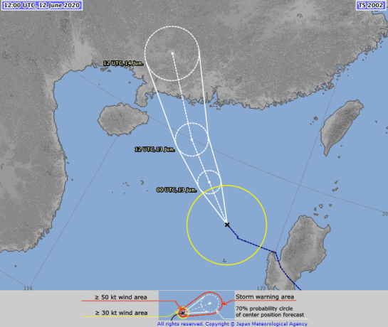

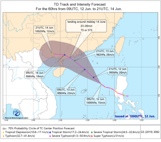


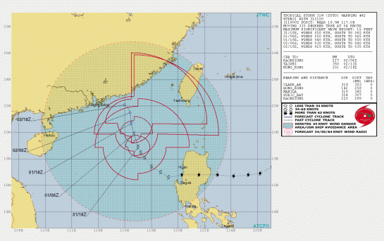


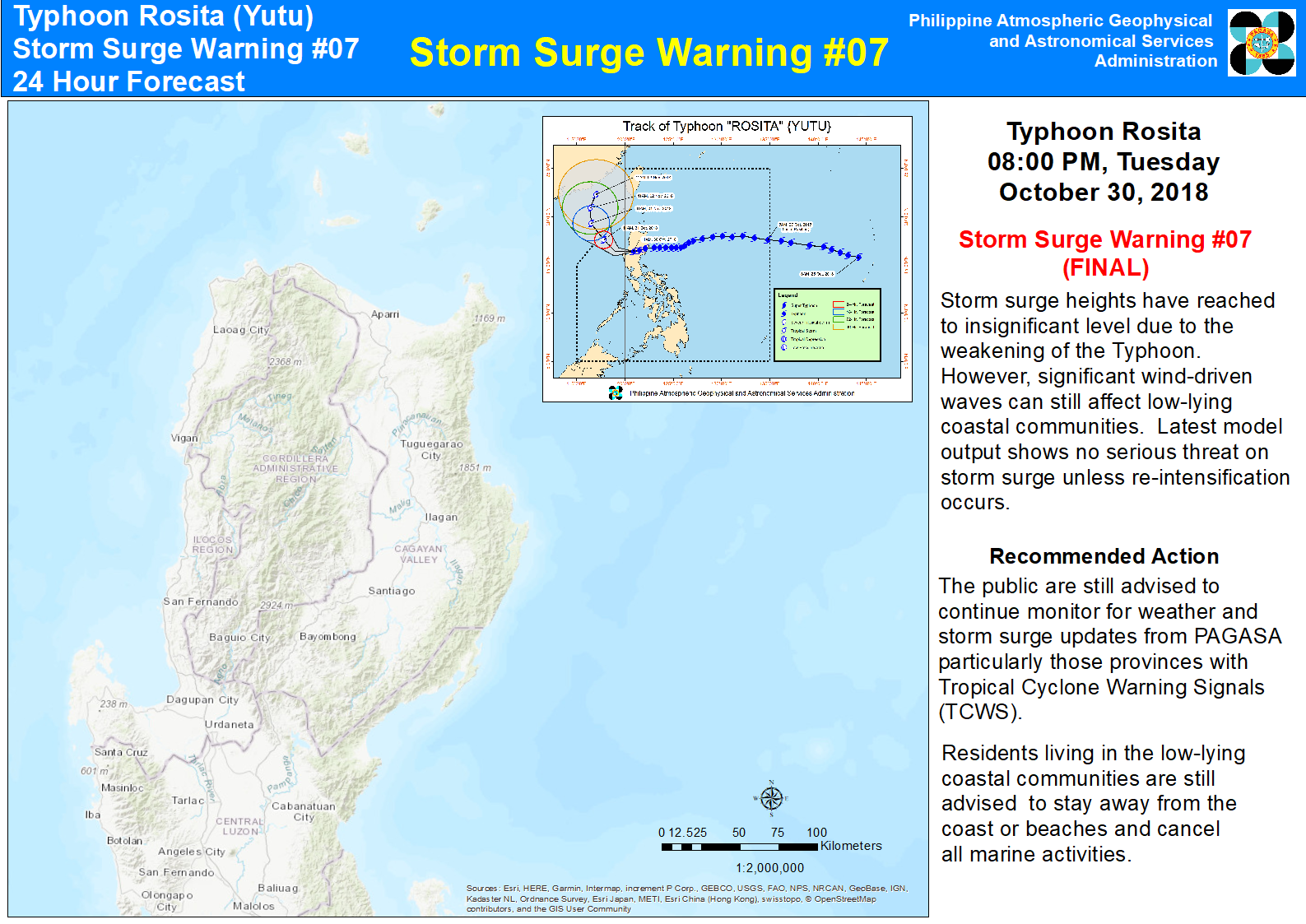


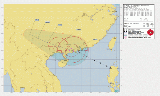

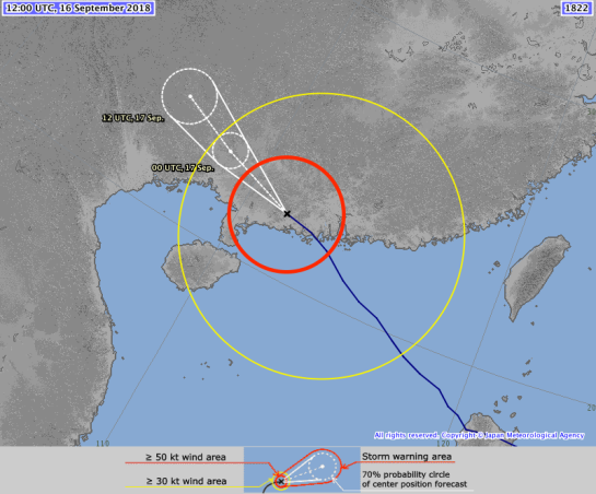


 will be displayed when the tropical cyclone is expected to weaken into a low pressure area or transform into an extratropical low.
 ) is based on Hong Kong Observatory’s hourly bulletin for public derived from the real-time satellite or radar-based positions.
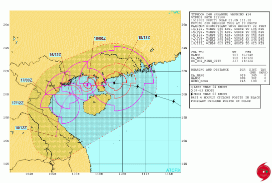
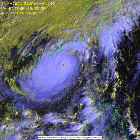

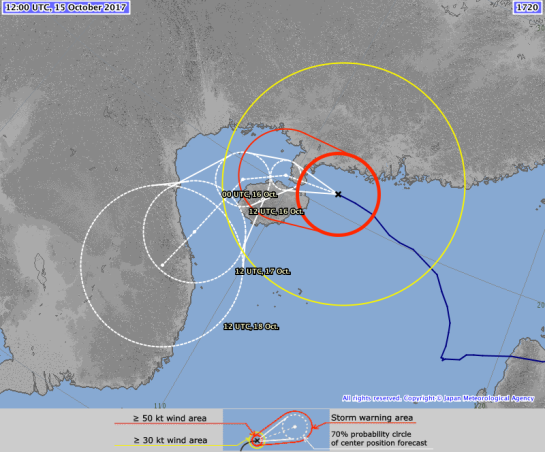
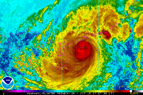
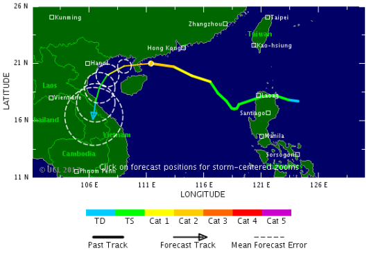
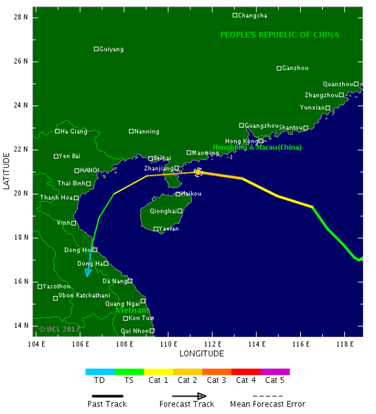
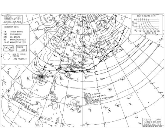

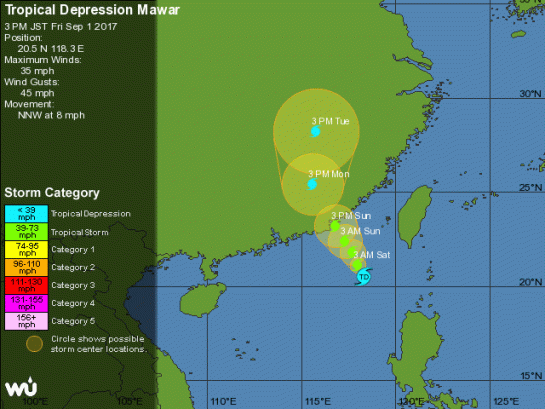
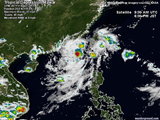
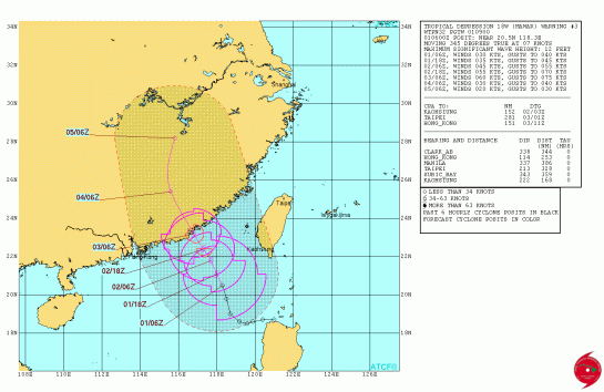
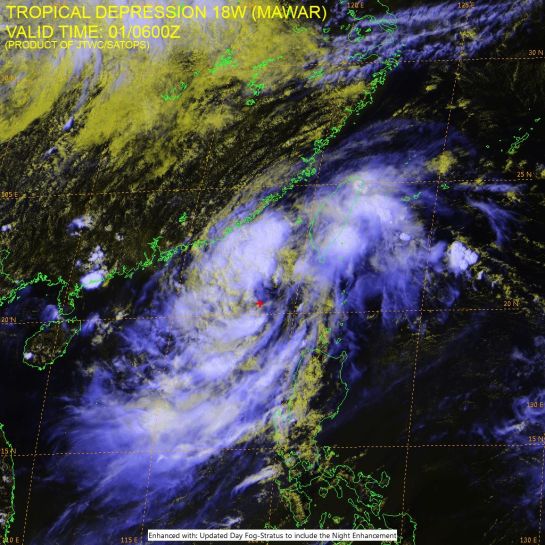
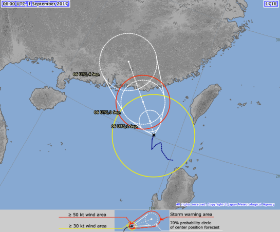
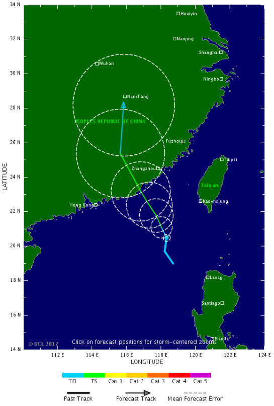
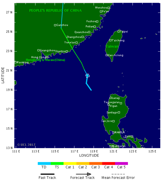
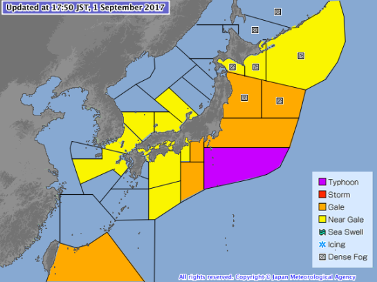
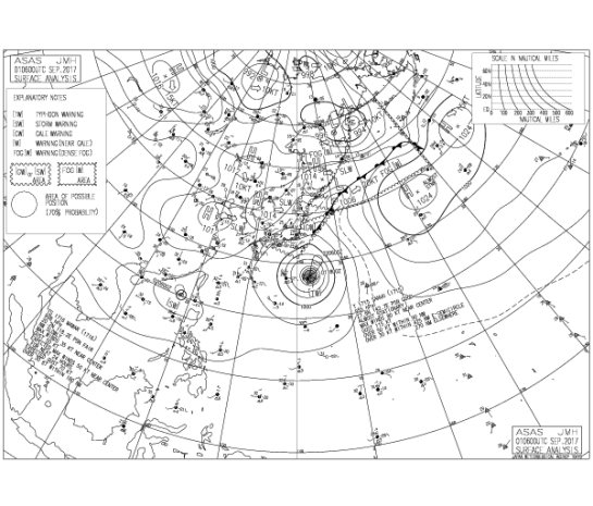

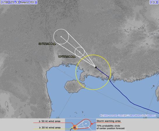


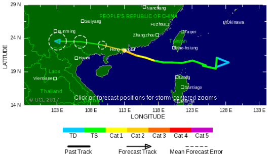
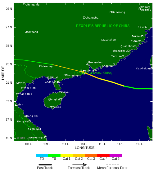


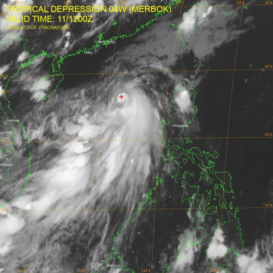

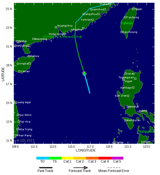


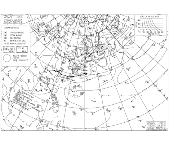


 Philippine Atmospheric, Geophysical and Astronomical Services Administration


 Philippine Atmospheric, Geophysical and Astronomical Services Administration (PAGASA-DOST)
 TY 1319 (USAGI)


 will be displayed when the tropical cyclone is expected to weaken into a low pressure area or transform into an extratropical low.
 ) is based on Hong Kong Observatory’s hourly bulletin for public derived from the real-time satellite or radar-based positions.


 “Tropical Storm Rumbia made landfall during the early morning hours on Tuesday bringing gale force winds and heavy rainfall the southernmost portions of China.


