Tropical Storm NURI 02W
“BUTCHOY” SLIGHTLY INTENSIFIES AS IT MOVES WEST-NORTHWESTWARD AWAY FROM LUZON (PAGASA)
The tropical cyclone now over the central part of the South China Sea is expected to intensify gradually, and will edge closer to the coast of western Guangdong in the next couple of days. (HKO)
![]()

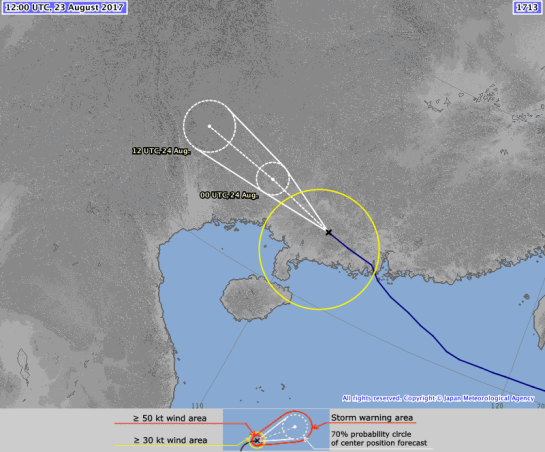
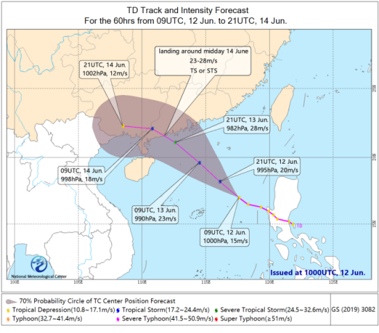
TS 2002 (Nuri)
Issued at 13:05 UTC, 12 June 2020
| <Analysis at 12 UTC, 12 June> | |
| Scale | – |
| Intensity | – |
| Center position | N16°50′ (16.8°) |
| E117°10′ (117.2°) | |
| Direction and speed of movement | W 20 km/h (11 kt) |
| Central pressure | 998 hPa |
| Maximum wind speed near center | 18 m/s (35 kt) |
| Maximum wind gust speed | 25 m/s (50 kt) |
| ≥ 30 kt wind area | ALL 220 km (120 NM) |
| <Forecast for 00 UTC, 13 June> | |
| Intensity | – |
| Center position of probability circle | N18°25′ (18.4°) |
| E115°25′ (115.4°) | |
| Direction and speed of movement | NW 20 km/h (12 kt) |
| Central pressure | 996 hPa |
| Maximum wind speed near center | 20 m/s (40 kt) |
| Maximum wind gust speed | 30 m/s (60 kt) |
| Radius of probability circle | 65 km (35 NM) |
| <Forecast for 12 UTC, 13 June> | |
| Intensity | – |
| Center position of probability circle | N20°00′ (20.0°) |
| E113°35′ (113.6°) | |
| Direction and speed of movement | NW 20 km/h (12 kt) |
| Central pressure | 992 hPa |
| Maximum wind speed near center | 23 m/s (45 kt) |
| Maximum wind gust speed | 35 m/s (65 kt) |
| Radius of probability circle | 95 km (50 NM) |
| <Forecast for 12 UTC, 14 June> | |
| Intensity | – |
| TD | |
| Center position of probability circle | N23°30′ (23.5°) |
| E110°20′ (110.3°) | |
| Direction and speed of movement | NW 20 km/h (12 kt) |
| Central pressure | 1002 hPa |
| Radius of probability circle | 165 km (90 NM) |
![]()
xxxxx
Philippines
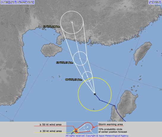
Tropical Depression”Butchoy”
Tropical Cyclone: ALERT
Issued at 11:00 am, 12 June 2020
(Valid for broadcast until the next advisory to be issued at 11:00 PM today or earlier.)
“BUTCHOY” SLIGHTLY INTENSIFIES AS IT MOVES WEST-NORTHWESTWARD AWAY FROM LUZON.
- Tropical Depression BUTCHOY is forecast to intensify into a tropical storm within 24 hours. It is also expected to exit the Philippine Area of Responsibility (PAR) tonight or tomorrow morning and is forecast to move generally northwestward towards southern China.
- All tropical cyclone wind signals have been lifted. However, occasional gusts associated with the Southwest Monsoon may still be experienced over most of Northern and Central Luzon and the western section of Southern Luzon and Visayas.
- Heavy Rainfall Outlook
- Today: Moderate to heavy rains over Zambales, Bataan, Pangasinan, the northern portion of Palawan including Calamian and Cuyo Islands, and Occidental Mindoro. Light to moderate with at times heavy monsoon rains over Metro Manila, Western Visayas, and the rest of Luzon.
- Flooding and rain-induced landslides may occur during heavy or prolonged rainfall especially in areas that are highly or very highly susceptible to these hazards. The public and disaster risk reduction and management offices are advised to take appropriate measures and monitor the Rainfall or Thunderstorm Advisories or Heavy Rainfall Warnings of PAGASA Regional Services Divisions.
- Coastal Water Conditions
- In the next 24 hours, moderate to very rough seas (1.5 to 4.5 m) will be experienced over the seaboards of Northern and Central Luzon especially over the seaboards of Ilocos Region, Zambales and Bataan due to BUTCHOY and the Southwest Monsoon. Sea travel is risky especially for those using small seacrafts.

At 10:00 AM today, the center of Tropical Depression “BUTCHOY” was estimated based on all available data at 140 km West Northwest of Iba, Zambales or 165 km West of Dagupan City, Pangasinan (15.9 °N, 118.8 °E )
Moving West Northwestward at 25 km/h
Maximum sustained winds of 55 km/h near the center and gustiness of up to 70 km/h
- 24 Hour(Tomorrow morning): 390 km West of Sinait, Ilocos Sur (OUTSIDE PAR)(17.4°N, 116.7°E)
- 48 Hour(Sunday morning):915 km West of Extreme Northern Luzon (OUTSIDE PAR)(20.9°N, 113.2°E)


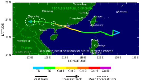
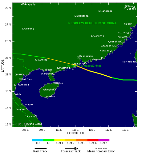
TROPICAL STORM RISK
University College London, UK
For graphical forecast information and further details please visit http://www.tropicalstormrisk.com/


Current probability of tropical storm winds

MARITIME/SHIPPING

WTJP21 RJTD 121200
WARNING 121200.
WARNING VALID 131200.
WARNING IS UPDATED EVERY 6 HOURS.
GALE WARNING.
TROPICAL STORM 2002 NURI (2002) UPGRADED FROM TROPICAL DEPRESSION 998
HPA
AT 16.8N 117.2E SOUTH CHINA SEA MOVING WEST 11 KNOTS.
POSITION POOR.
MAX WINDS 35 KNOTS NEAR CENTER.
RADIUS OF OVER 30 KNOT WINDS 120 MILES.
FORECAST POSITION FOR 130000UTC AT 18.4N 115.4E WITH 35 MILES RADIUS
OF 70 PERCENT PROBABILITY CIRCLE.
996 HPA, MAX WINDS 40 KNOTS NEAR CENTER.
FORECAST POSITION FOR 131200UTC AT 20.0N 113.6E WITH 50 MILES RADIUS
OF 70 PERCENT PROBABILITY CIRCLE.
992 HPA, MAX WINDS 45 KNOTS NEAR CENTER.
EXTENDED OUTLOOK.
FORECAST POSITION FOR 141200UTC AT 23.5N 110.3E WITH 90 MILES RADIUS
OF 70 PERCENT PROBABILITY CIRCLE.
1002 HPA.
BECOMING TROPICAL DEPRESSION.
JAPAN METEOROLOGICAL AGENCY.=
CHINA
MESSAGE FOR NAVAREA XI(IOR) ISSUED BY NMC BEIJING
AT 1015UTC JUN.12 2020=
MESSAGE IS UPDATED EVERY 06 HOURS=
SYNOPSIS VALID 0600UTC JUN.12=
FCST VALID 0600UTC JUN.13=
WARNNING=
NIL=
SUMMARY=
TD(01) 1000HPA AT 16.5N 118.3E MVG WNW 17KMH
AND MAX WINDS 15M/S NEAR CENTER(SEAS UP TO 4.0M)
AND FCST FOR 130600UTC AT 18.9N 115.0E 990HPA
AND MAX WINDS 23M/S NEAR CENTER=
SW WINDS FROM 12 TO 14M/S GUSTS 16M/S SEAS UP TO
3.0M OVER SEA SOUTH OF JAPAN=
SE WINDS FROM 12 TO 16M/S GUSTS 18M/S SEAS UP TO
2.5M OVER BASHI CHANNEL AND SEA EAST OF THE
PHILIPPINES
AND NORTHEASTERN PART OF SOUTH CHINA SEA=
DENSE FOG OBSERVED LOCALLY OVER BOHAI STRAIT AND
NORTHERN AND CENTRAL PARTS OF YELLOW SEA AND
SOUTHWESTERN PART OF JAPAN SEA AND HORIZONTAL
VISIBILITY LESS THAN 1KM=
HORIZONTAL VISIBILITY LESS THAN 10KM ALSO OVER
NORTHERN PART OF EAST CHINA SEA AND KOREA STRAIT
AND SEA SOUTH OF JAPAN AND EAST CENTRAL SOUTH
CHINA SEA AND ANDAMAN SEA AND LAUT MALUKU=
FCST=
BOHAI SEA
S WINDS 04 TO 07M/S SEA STATE SLT TO SMOOTH FOG
VIS POOR TO MOD=
BOHAI STRAIT
S WINDS BACK E 04 TO 07M/S SEA STATE SMOOTH HVY
FOG VIS VERY POOR=
NORTHERN PART OF YELLOW SEA
S WINDS BACK E 04 TO 07M/S SEA STATE SMOOTH HVY
FOG VIS VERY POOR=
CENTRAL PART OF YELLOW SEA
E WINDS 04 TO 07M/S INCR 07 TO 10M/S GUSTS 08 TO
12M/S SEA STATE SLT FOG BECMG HVY FOG VIS VERY
POOR=
SOUTHERN PART OF YELLOW SEA
E WINDS VEER SW 07 TO 10M/S SEA STATE SLT TO MOD
MOD RAIN BECMG HVY RAIN VIS VERY POOR=
NORTHERN PART OF EAST CHINA SEA
S WINDS 07 TO 10M/S GUSTS 08 TO 12M/S VEER SW
WINDS 08 TO 12M/S GUSTS 12 TO 15M/S SEA STATE MOD
OVERCAST BECMG CLOUDY VIS POOR TO GOOD=
SOUTHERN PART OF EAST CHINA SEA
S WINDS 08 TO 12M/S GUSTS 12 TO 15M/S SEA STATE
MOD OVERCAST VIS GOOD=
TAIWAN STRAIT
SE WINDS 08 TO 12M/S GUSTS 12 TO 15M/S SEA STATE
MOD OVERCAST VIS GOOD TO MOD=
SEA EAST OF TAIWAN
S WINDS 07 TO 10M/S GUSTS 08 TO 12M/S INCR 08 TO
12M/S GUSTS 12 TO 15M/S SEA STATE MOD OVERCAST
VIS POOR=
BASHI CHANNEL
SE WINDS 12 TO 15M/S GUSTS 14 TO 18M/S SEA STATE
ROUGH OVERCAST VIS POOR TO MOD=
NORTHEASTERN PART OF SOUTH CHINA SEA
E WINDS 12 TO 15M/S GUSTS 14 TO 18M/S BECMG
CYCLONIC WINDS 14 TO 18M/S GUSTS 18 TO 24M/S SEA
STATE ROUGH TO VERY ROUGH OVERCAST VIS POOR TO
VERY=
EAST CENTRAL SOUTH CHINA SEA
CYCLONIC WINDS 14 TO 18M/S GUSTS 18 TO 24M/S SEA
STATE ROUGH HVY RAIN VIS VERY POOR=
SOUTHWESTERN PART OF SOUTH CHINA SEA
SW WINDS 07 TO 10M/S SEA STATE MOD CLOUDY BECMG
LIGHT RAIN VIS POOR=
SOUTHEASTERN PART OF SOUTH CHINA SEA
SW WINDS 07 TO 10M/S SEA STATE MOD CLOUDY BECMG
LIGHT RAIN VIS POOR=
NORTHEASTERN PART OF JAPAN SEA
W WINDS BACK SW 07 TO 10M/S SEA STATE SLT HVY FOG
VIS MOD TO POOR=
SOUTHWESTERN PART OF JAPAN SEA
S WINDS VEER SW 04 TO 07M/S SEA STATE SLT HVY FOG
VIS POOR TO VERY=
KOREA STRAIT
SW WINDS 07 TO 10M/S GUSTS 08 TO 12M/S INCR 08 TO
12M/S GUSTS 12 TO 15M/S SEA STATE SLT TO MOD FOG
BECMG RAINSTORM VIS VERY POOR=
SEA SOUTH OF JAPAN
SW WINDS 12 TO 15M/S GUSTS 14 TO 18M/S DECR 08 TO
12M/S GUSTS 12 TO 15M/S SEA STATE MOD LIGHT RAIN
BECMG OVERCAST VIS VERY POOR TO POOR=
SEA NORTHEAST OF THE PHILIPPINES
SE WINDS 08 TO 12M/S GUSTS 12 TO 15M/S DECR 07 TO
10M/S GUSTS 08 TO 12M/S SEA STATE MOD OVERCAST
VIS POOR TO MOD=
SEA SOUTHEAST OF THE PHILIPPINES
E WINDS 04 TO 07M/S INCR 07 TO 10M/S GUSTS 08 TO
12M/S SEA STATE MOD CLOUDY VIS POOR TO MOD=
SEA WEST OF GUAM
E WINDS 07 TO 10M/S SEA STATE MOD LIGHT RAIN VIS
POOR=
SEA SOUTHWEST OF THE PHILIPPINES
SE WINDS 04 TO 07M/S SEA STATE SLT CLOUDY VIS MOD
TO POOR=
SEA NORTHEAST OF INDONESIA
E WINDS 04 TO 07M/S SEA STATE SLT TO MOD LIGHT
RAIN VIS POOR=
SEA SOUTHEAST OF INDONESIA
SE WINDS 07 TO 10M/S SEA STATE MOD LIGHT RAIN VIS
POOR=
SEA SOUTH OF JAWA
SE WINDS 07 TO 10M/S SEA STATE MOD CLOUDY VIS MOD=
SEA WEST OF SUMATERA
SE WINDS 07 TO 10M/S GUSTS 08 TO 12M/S INCR 08 TO
12M/S GUSTS 12 TO 15M/S SEA STATE MOD TO ROUGH
CLOUDY VIS POOR TO MOD=
MALACCA STRAIT
SE WINDS VEER S 04 TO 07M/S SEA STATE SLT CLOUDY
VIS POOR TO MOD=
SEA EAST OF SINGAPORE
SW WINDS 04 TO 07M/S BACK S WINDS 07 TO 10M/S SEA
STATE SMOOTH TO SLT LIGHT RAIN BECMG CLOUDY VIS
POOR=
SEA SOUTH OF VIETNAM
W WINDS BACK SW 07 TO 10M/S SEA STATE SLT LIGHT
RAIN VIS POOR=
GULF OF THAILAND
W WINDS 04 TO 07M/S INCR 07 TO 10M/S GUSTS 08 TO
12M/S SEA STATE SLT CLOUDY BECMG LIGHT RAIN VIS
POOR=
ANDAMAN SEA
SW WINDS VEER W 04 TO 07M/S SEA STATE MOD CLOUDY
BECMG LIGHT RAIN VIS POOR=
海事公报(北京,中央气象台)
2020年06月12日1015时(世界时)
06月12日0600时(世界时)海事分析
06月13日0600时(世界时)海事预报
海事分析
热带低压(01)位于北纬16.5度、东经118.3度,中心气压1000百帕,中心附近最大风速15米/秒,浪高4.0米,以17公里/小时的速度向西西北方向移动。
预计13日0600时(世界时)位于北纬18.9度、东经115.0度,中心气压990百帕,中心附近最大风速23米/秒。
日本以南洋面出现了6~7级、阵风8级的西南风,浪高3.0米;
巴士海峡、菲律宾以东洋面、南海东北部海域出现了6~7级、阵风8级的东南风,浪高2.5米;
渤海海峡、黄海北部和中部海域、日本海西南部海域出现了能见度不足1公里的大雾。
能见度不足10公里的海域还有东海北部海域、朝鲜海峡、日本以南洋面、南海中东部海域、安达曼海以及马鲁古海等海域。
海事预报
渤海
南风3~4级,海况轻浪转小浪,雾,能见度差转中等。
渤海海峡
南风转东风3~4级,海况小浪,大雾,能见度极差。
黄海北部海域
南风转东风3~4级,海况小浪,大雾,能见度极差。
黄海中部海域
东风3~4级增大至4~5级,海况轻浪,雾转大雾,能见度极差。
黄海南部海域
东风转西南风4~5级,海况轻浪转中浪,中雨转大雨,能见度极差。
东海北部海域
南风4~5级、阵风5~6级转西南风5~6级、阵风6~7级,海况中浪,阴转多云,能见度差转好。
东海南部海域
南风5~6级、阵风6~7级,海况中浪,阴,能见度好。
台湾海峡
东南风5~6级、阵风6~7级,海况中浪,阴,能见度好转中等。
台湾以东洋面
南风4~5级、阵风5~6级增大至5~6级、阵风6~7级,海况中浪,阴,能见度差。
巴士海峡
东南风6~7级、阵风7~8级,海况大浪,阴,能见度差转中等。
南海东北部海域
东风6~7级、阵风7~8级转旋转风7~8级、阵风8~9级,海况大浪转巨浪,阴,能见度差转极差。
南海中东部海域
旋转风7~8级、阵风8~9级,海况大浪,大雨,能见度极差。
南海西南部海域
西南风4~5级,海况中浪,多云转小雨,能见度差。
南海东南部海域
西南风4~5级,海况中浪,多云转小雨,能见度差。
日本海东北部海域
西风转西南风4~5级,海况轻浪,大雾,能见度中等转差。
日本海西南部海域
南风转西南风3~4级,海况轻浪,大雾,能见度差转极差。
朝鲜海峡
西南风4~5级、阵风5~6级增大至5~6级、阵风6~7级,海况轻浪转中浪,雾转暴雨,能见度极差。
日本以南洋面
西南风6~7级、阵风7~8级减小至5~6级、阵风6~7级,海况中浪,小雨转阴,能见度极差转差。
菲律宾东北洋面
东南风5~6级、阵风6~7级减小至4~5级、阵风5~6级,海况中浪,阴,能见度差转中等。
菲律宾东南洋面
东风3~4级增大至4~5级,海况中浪,多云,能见度差转中等。
关岛以西洋面
东风4~5级,海况中浪,小雨,能见度差。
菲律宾西南海域
东南风3~4级,海况轻浪,多云,能见度中等转差。
印度尼西亚东北海域
东风3~4级,海况轻浪转中浪,小雨,能见度差。
印度尼西亚东南海域
东南风4~5级,海况中浪,小雨,能见度差。
爪哇岛以南海域
东南风4~5级,海况中浪,多云,能见度中等。
苏门答腊以西洋面
东南风4~5级、阵风5~6级增大至5~6级、阵风6~7级,海况中浪转大浪,多云,能见度差转中等。
马六甲海峡
东南风转南风3~4级,海况轻浪,多云,能见度差转中等。
新加坡以东海域
西南风3~4级转南风4~5级,海况小浪转轻浪,小雨转多云,能见度差。
越南以南海域
西风转西南风4~5级,海况轻浪,小雨,能见度差。
泰国湾
西风3~4级增大至4~5级,海况轻浪,多云转小雨,能见度差。
安达曼海
西南风转西风3~4级,海况中浪,多云转小雨,能见度差。
Hong Kong
Bulletin issued at 21:30 HKT 12/Jun/2020
Tropical depression over the central part of the South China Sea with central pressure 998 hectopascals was named Nuri. At 121200 UTC, it was centred within 90 nautical miles of one six point seven degrees north (16.7 N) one one seven point eight degrees east (117.8 E) and is forecast to move northwest at about 12 knots for the next 24 hours.
Maximum winds near the centre are estimated to be 30 knots. Radius of over 2 metre waves 180 nautical miles.
Forecast position and intensity at 131200 UTC Two zero point three degrees north (20.3 N) One one four point three degrees east (114.3 E) Maximum winds 50 knots. Forecast position and intensity at 141200 UTC Two three point seven degrees north (23.7 N) One one one point one degrees east (111.1 E) Maximum winds 25 knots. Forecast position and intensity at 151200 UTC Dissipated over land.
The Hong Kong Observatory’s tropical cyclone warnings for shipping are issued about one and a half hours after the time of observation. They incorporate additional information derived from surface and upper-air data and may therefore be slightly different from the real-time satellite or radar-based positions given in the hourly bulletins for public.
While the forecast positions and track indicate the most likely future path of the tropical cyclone, they may deviate from the actual path taken by the storm.
Tropical Cyclone Warning | Track and Positions of Tropical Cyclones
Current Weather | Local Weather Forecast | 9-day Weather Forecast
South China Coastal Waters | Marine Forecast
This link will open in a new windowSevere Weather Information Centre
Philippines Tropical Cyclone Warning (link)
=========================================================================


 will be displayed when the tropical cyclone is expected to weaken into a low pressure area or transform into an extratropical low.
 ) is based on Hong Kong Observatory’s hourly bulletin for public derived from the real-time satellite or radar-based positions.