Tropical Storm 1404 (PEIPAH) (JMA)
Tropical Storm
Philippines: Coastal areas in at least 5 provinces are being advised to prepare for possible storm surges and high tides (See below)
(JTWC)


 TS 1404 (PEIPAH)
Issued at 12:45 UTC, 7 April 2014
 |
| <Analyses at 07/12 UTC> |
| Scale |
– |
| Intensity |
– |
| Center position |
N6°30′(6.5°) |
|
E131°50′(131.8°) |
| Direction and speed of movement |
WSW Slowly |
| Central pressure |
1000hPa |
| Maximum sustained wind speed |
18m/s(35kt) |
| Maximum wind gust speed |
25m/s(50kt) |
| Area of 30kt winds or more |
NW390km(210NM) |
|
SE220km(120NM) |
|
| <Forecast for 08/12 UTC> |
| Intensity |
– |
| Center position of probability circle |
N7°20′(7.3°) |
|
E129°55′(129.9°) |
| Direction and speed of movement |
WNW Slowly |
| Central pressure |
998hPa |
| Maximum wind speed near the center |
18m/s(35kt) |
| Maximum wind gust speed |
25m/s(50kt) |
| Radius of probability circle |
130km(70NM) |
|
| <Forecast for 09/12 UTC> |
| Intensity |
– |
| Center position of probability circle |
N7°55′(7.9°) |
|
E128°05′(128.1°) |
| Direction and speed of movement |
WNW Slowly |
| Central pressure |
996hPa |
| Maximum wind speed near the center |
20m/s(40kt) |
| Maximum wind gust speed |
30m/s(60kt) |
| Radius of probability circle |
200km(110NM) |
|
| <Forecast for 10/12 UTC> |
| Intensity |
– |
| Center position of probability circle |
N8°35′(8.6°) |
|
E126°55′(126.9°) |
| Direction and speed of movement |
WNW Slowly |
| Central pressure |
994hPa |
| Maximum wind speed near the center |
20m/s(40kt) |
| Maximum wind gust speed |
30m/s(60kt) |
| Radius of probability circle |
300km(160NM) |
Unit:
1KT(knot) = 1.852 km/h = 0.5144 m/s
1NM(nautical mile) = 1.852 km


932
WTPQ31 PGUM 071000 CCA
TCPPQ1
TROPICAL DEPRESSION PEIPAH (05W) ADVISORY NUMBER 18…CORRECTED
NATIONAL WEATHER SERVICE TIYAN GU WP052014
800 PM CHST MON APR 7 2014
CORRECTED SPEED OF MOVEMENT IN SUMMARY
…TROPICAL DEPRESSION 05W (PEIPAH) MOVING WEST-SOUTHWESTWARD…
WATCHES AND WARNINGS
——————–
NONE.
SUMMARY OF 700 PM CHST…0900 UTC…INFORMATION
———————————————–
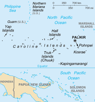
LOCATION…6.4N 131.8E
ABOUT 165 MILES WEST-SOUTHWEST OF ANGAUR
ABOUT 170 MILES WEST-SOUTHWEST OF PELELIU
ABOUT 190 MILES WEST-SOUTHWEST OF KOROR PALAU
ABOUT 230 MILES WEST-SOUTHWEST OF KAYANGEL PALAU AND
ABOUT 480 MILES WEST-SOUTHWEST OF YAP
MAXIMUM SUSTAINED WINDS…30 MPH
PRESENT MOVEMENT…WEST-SOUTHWEST OR 240 DEGREES AT 17 MPH
DISCUSSION AND OUTLOOK
———————-
AT 700 PM CHST…0900 UTC…THE CENTER OF TROPICAL DEPRESSION PEIPAH
WAS LOCATED BY SATELLITE NEAR LATITUDE 6.4 DEGREES NORTH AND
LONGITUDE 131.8 DEGREES EAST.
TROPICAL DEPRESSION PEIPAH IS MOVING WEST-SOUTHWEST AT 17 MPH.
PEIPAH IS EXPECTED TO TURN BACK TO THE WEST-NORTHWEST WITH A
DECREASE IN FORWARD SPEED THROUGH TUESDAY.
MAXIMUM SUSTAINED WINDS REMAIN AT 30 MPH. TROPICAL DEPRESSION PEIPAH
IS EXPECTED TO REMAIN AT THIS INTENSITY THROUGH TUESDAY NIGHT.
NEXT ADVISORY
————-
THE NEXT SCHEDULED ADVISORY WILL BE ISSUED BY THE NATIONAL WEATHER
SERVICE AT 200 AM EARLY TUESDAY MORNING.
$$
STANKO
Philippines
Philippine Atmospheric, Geophysical and Astronomical Services Administration (PAGASA-DOST) Twitter: Facebook: https://www.facebook.com/PAGASA.DOST.GOV.PH

For more information and queries, please call at telephone numbers 927-1335 and 927-2877 or log on to www.pagasa.dost.gov.ph.
Joint Typhoon Warning Center (JTWC)


WTPN31 PGTW 071500
MSGID/GENADMIN/JOINT TYPHOON WRNCEN PEARL HARBOR HI//
SUBJ/TROPICAL CYCLONE WARNING//
RMKS/
1. TROPICAL DEPRESSION 05W (PEIPAH) WARNING NR 019
01 ACTIVE TROPICAL CYCLONE IN NORTHWESTPAC
MAX SUSTAINED WINDS BASED ON ONE-MINUTE AVERAGE
WIND RADII VALID OVER OPEN WATER ONLY
—
WARNING POSITION:
071200Z — NEAR 6.4N 131.8E
MOVEMENT PAST SIX HOURS – 255 DEGREES AT 04 KTS
POSITION ACCURATE TO WITHIN 060 NM
POSITION BASED ON CENTER LOCATED BY SATELLITE
PRESENT WIND DISTRIBUTION:
MAX SUSTAINED WINDS – 025 KT, GUSTS 035 KT
WIND RADII VALID OVER OPEN WATER ONLY
REPEAT POSIT: 6.4N 131.8E
—
FORECASTS:
12 HRS, VALID AT:
080000Z — 6.4N 131.3E
MAX SUSTAINED WINDS – 025 KT, GUSTS 035 KT
WIND RADII VALID OVER OPEN WATER ONLY
VECTOR TO 24 HR POSIT: 290 DEG/ 03 KTS
—
24 HRS, VALID AT:
081200Z — 6.6N 130.8E
MAX SUSTAINED WINDS – 030 KT, GUSTS 040 KT
WIND RADII VALID OVER OPEN WATER ONLY
VECTOR TO 36 HR POSIT: 315 DEG/ 03 KTS
—
36 HRS, VALID AT:
090000Z — 7.0N 130.4E
MAX SUSTAINED WINDS – 030 KT, GUSTS 040 KT
WIND RADII VALID OVER OPEN WATER ONLY
VECTOR TO 48 HR POSIT: 315 DEG/ 04 KTS
—
EXTENDED OUTLOOK:
48 HRS, VALID AT:
091200Z — 7.5N 129.9E
MAX SUSTAINED WINDS – 030 KT, GUSTS 040 KT
WIND RADII VALID OVER OPEN WATER ONLY
VECTOR TO 72 HR POSIT: 310 DEG/ 04 KTS
—
72 HRS, VALID AT:
101200Z — 8.4N 128.8E
MAX SUSTAINED WINDS – 035 KT, GUSTS 045 KT
WIND RADII VALID OVER OPEN WATER ONLY
VECTOR TO 96 HR POSIT: 305 DEG/ 06 KTS
—
LONG RANGE OUTLOOK:
—
96 HRS, VALID AT:
111200Z — 9.7N 126.8E
MAX SUSTAINED WINDS – 040 KT, GUSTS 050 KT
WIND RADII VALID OVER OPEN WATER ONLY
VECTOR TO 120 HR POSIT: 300 DEG/ 07 KTS
—
120 HRS, VALID AT:
121200Z — 11.1N 124.3E
MAX SUSTAINED WINDS – 035 KT, GUSTS 045 KT
WIND RADII VALID OVER OPEN WATER ONLY
DISSIPATING AS A SIGNIFICANT TROPICAL CYCLONE OVER WATER
—
REMARKS:
071500Z POSITION NEAR 6.4N 131.7E.
TROPICAL DEPRESSION (TD) 05W (PEIPAH), LOCATED APPROXIMATELY 804 NM
SOUTHEAST OF MANILA, PHILIPPINES, HAS TRACKED WEST-SOUTHWESTWARD AT
04 KNOTS OVER THE PAST SIX HOURS. MAXIMUM SIGNIFICANT WAVE HEIGHT
AT 071200Z IS 13 FEET. NEXT WARNINGS AT 072100Z, 080300Z, 080900Z
AND 081500Z.//
NNNN
Other Reports
“Tropical Storm Peipah (Bagyong Domeng) continues to struggle amidst the moderate wind shear in the region. The system is now leaving the Republic of Palau and moving towards the Philippines. The center was last located approximately 120km west southwest of Koror, Palau or about 870km east of Davao City. Maximum sustained winds remain at 65kph with gusts of up to 93kph according to Japan Meteorological Agency. Peipah is moving westward at 20kph.
IR Image from NRLMRY

Latest satellite image shows how poorly organized Peipha is currently. The convection continues to get sheared to the west and the low-level circulation center is almost fully exposed this morning. In fact, the Joint Typhoon Warning Center has downgraded Peipha to a Tropical Depression on their latest warning. Due to the atmospheric conditions in the region, Peipah will likely struggle to intensify in the coming days and may not even become a Typhoon anymore.
Rainfall Forecast from COAMPS

Tropical Storm Peipah brought over 150mm of rainfall across Palau yesterday. We expect this similar amount, if not more, to fall across the Southern Philippines in the next three days. Light rains may actually start impacting Mindanao tonight and into tomorrow as the system moves from the east. Aside from the rains, the threat of storm surge and strong winds should also be kept in mind especially for residents living along the eastern coastline.
We’ll continue to post updates on this system so stay with Western Pacific Weather. As always, follow your official agency’s forecast (PAGASA) for the latest warnings on this storm.”- rpweather
Domeng storm surge warning in 5 provinces – Rappler.com
Updated 9:52 PM, Apr 07, 2014 (PhT)
Coastal areas in at least 5 provinces are being advised to prepare for possible storm surges and high tides
http://www.rappler.com/nation/54886-storm-surge-warning-domeng
==================================================

(Image: wikimedia.org)
(Image: wikimedia.org)
MARITIME
Philippines
Tropical Cyclone Warning For Shipping
WTPH RPMM 070600
TTT WARNING 05
AT 0600 07 APRIL TROPICAL DEPRESSION (PEIPAH) {1404} DOWNGRADED FROM TROPICAL STORM WAS ESTIMATED AT ZERO SIX POINT SIX NORTH ONE THREE TWO POINT THREE EAST FORECAST TO MOVE WEST NORTHWEST AT ZERO THREE METERS PER SECOND MODERATE TO ROUGH SEAS WITHIN TWO ZERO ZERO KILOMETER RADIUS FROM CENTER ESTIMATED CENTRAL PRESSURE ONE ZERO ZERO ZERO HECTOPASCALS MAXIMUM WINDS ONE FIVE METERS PER SECOND NEAR CENTER ONE THREE METERS PER SECOND WITHIN TWO ZERO ZERO KILOMETER RADIUS FROM CENTER FORECAST POSITIONS AT 080600 ZERO SEVEN POINT ONE NORTH ONE TWO NINE POINT SEVEN EAST AT 090600 ZERO SEVEN POINT EIGHT NORTH ONE TWO EIGHT POINT ONE EAST AND AT 100600 ZERO EIGHT POINT SEVEN NORTH ONE TWO SIX POINT SEVEN EAST ALL SHIPS WITHIN DEPRESSION AREA ARE REQUESTED TO SEND THREE HOURLY WEATHER REPORT TO WEATHER MANILA PD
WEATHER MANILA
http://www.pagasa.dost.gov.ph/tropical-cyclone/tropical-cyclone-warning-for-shipping
METAREA11 / TYPHOON_WARNING_JAPAN / 1200
WTJP21 RJTD 071200
WARNING 071200.
WARNING VALID 081200.
WARNING IS UPDATED EVERY 6 HOURS.
GALE WARNING.
TROPICAL STORM 1404 PEIPAH (1404) 1000 HPA
AT 06.5N 131.8E SEA EAST OF MINDANAO MOVING WESTSOUTHWEST SLOWLY.
POSITION FAIR.
MAX WINDS 35 KNOTS.
RADIUS OF OVER 30 KNOT WINDS 210 MILES NORTHWEST SEMICIRCLE AND 120
MILES ELSEWHERE.
FORECAST POSITION FOR 081200UTC AT 07.3N 129.9E WITH 70 MILES RADIUS
OF 70 PERCENT PROBABILITY CIRCLE.
998 HPA, MAX WINDS 35 KNOTS NEAR CENTER.
EXTENDED OUTLOOK.
FORECAST POSITION FOR 091200UTC AT 07.9N 128.1E WITH 110 MILES RADIUS
OF 70 PERCENT PROBABILITY CIRCLE.
996 HPA, MAX WINDS 40 KNOTS NEAR CENTER.
FORECAST POSITION FOR 101200UTC AT 08.6N 126.9E WITH 160 MILES RADIUS
OF 70 PERCENT PROBABILITY CIRCLE.
994 HPA, MAX WINDS 40 KNOTS NEAR CENTER.
JAPAN METEOROLOGICAL AGENCY.
METAREA XI
Do not use any information on this site for life or death decisions. All information is intended as supplementary to official sources. Kindly refer to your country’s official weather agency/government website for local warnings, advisories and bulletins.


 about the continued search for Mrs Catherine PRIDHAM.