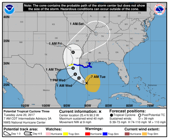
Mexico/ US: Tropical Storm HANNA 26/1500Z 26.1N 99.7W, moving WSW ~8.09kt. Wind ~40.49kt. 995mb (NHC FL) – Updated 26 Jul 2020 1655Z (GMT/UTC)

Tropical Storm HANNA

…CENTER OF HANNA CONTINUES TO MOVE INLAND OVER NORTHEASTERN
MEXICO…
…HEAVY RAIN AND DANGEROUS FLASH FLOODING CONTINUES OVER FAR
SOUTHEAST TEXAS AND NORTHEAST MEXICO…

Mexico beware!

A Tropical Storm Warning is in effect for…
* Barra el Mezquital Mexico to the Mouth of the Rio Grande

Interests in northeastern Mexico should monitor the progress of
Hanna.

The center of Hanna should continue to move farther inland
over northeastern Mexico through tonight.

National Hurricane Center (FL)


145044_5day_cone_no_line_and_wind


704
WTNT33 KNHC 261444
TCPAT3

BULLETIN
Tropical Storm Hanna Advisory Number 15
NWS National Hurricane Center Miami FL AL082020
1000 AM CDT Sun Jul 26 2020

…CENTER OF HANNA CONTINUES TO MOVE INLAND OVER NORTHEASTERN
MEXICO…
…HEAVY RAIN AND DANGEROUS FLASH FLOODING CONTINUES OVER FAR
SOUTHEAST TEXAS AND NORTHEAST MEXICO…
SUMMARY OF 1000 AM CDT…1500 UTC…INFORMATION
———————————————–
LOCATION…26.1N 99.7W
ABOUT 75 MI…120 KM NE OF MONTERREY MEXICO
ABOUT 90 MI…150 KM W OF MCALLEN TEXAS
MAXIMUM SUSTAINED WINDS…45 MPH…75 KM/H
PRESENT MOVEMENT…WSW OR 250 DEGREES AT 9 MPH…15 KM/H
MINIMUM CENTRAL PRESSURE…995 MB…29.39 INCHES
WATCHES AND WARNINGS
——————–
CHANGES WITH THIS ADVISORY:

The Tropical Storm Warning along the coast of Texas south of Baffin
Bay has been discontinued.

SUMMARY OF WATCHES AND WARNINGS IN EFFECT:

A Tropical Storm Warning is in effect for…
* Barra el Mezquital Mexico to the Mouth of the Rio Grande

Interests in northeastern Mexico should monitor the progress of
Hanna.

For storm information specific to your area, please monitor
products issued by your national meteorological service.
DISCUSSION AND OUTLOOK
———————-
At 1000 AM CDT (1500 UTC), the center of Tropical Storm Hanna was
located near latitude 26.1 North, longitude 99.7 West. Hanna is
moving toward the west-southwest near 9 mph (15 km/h) and this
motion is expected to continue through Monday. On the forecast
track, the center of Hanna should continue to move farther inland
over northeastern Mexico through tonight.

Maximum sustained winds have decreased to near 45 mph (75 km/h)
with higher gusts. Additional weakening is expected as the
center of Hanna moves farther inland, and the cyclone is expected
to weaken to a tropical depression later today and dissipate Monday
or Monday night.

Tropical-storm-force winds extend outward up to 105 miles (165 km)
from the center.

The estimated minimum central pressure is 995 mb (29.39 inches).
HAZARDS AFFECTING LAND
———————-
Key messages for Hanna can be found in the Tropical Cyclone
Discussion under AWIPS header MIATCDAT3, WMO header WTNT43 KNHC and
on the web at http://www.hurricanes.gov/text/MIATCDAT3.shtml.

STORM SURGE: Water levels along the Texas coast will gradually
subside through this afternoon. Consult products issued by your
local National Weather Service forecast office for additional
information.

WIND: Tropical storm conditions will continue near the center of
Hanna for the next several hours, and along the coast of Mexico
within the warning area for a few more hours.

RAINFALL: Hanna is expected to produce the following rain
accumulations and flood threats through Monday:

South Texas…Additional 2 to 5 inches. Storm total amounts 6 to 12
inches, isolated 16 inches.
Northern Mexican states of Coahuila, Nuevo Leon, Tamaulipas…6 to
12 inches, isolated 16 inches.
Northern Mexican states of northern Zacatecas and eastern
Durango…1 to 4 inches.

This rain will produce life-threatening flash flooding, rapid rises
on small streams, and isolated minor to moderate river flooding in
South Texas. Flash flooding and mudslides are likely across Northern
Mexican states.

SURF: Swells generated by Hanna will continue to affect much
of the Texas and Louisiana coasts for another day or so. These
swells are likely to cause life-threatening surf and rip current
conditions. Please consult products from your local weather
office.

TORNADOES: A few tornadoes are possible today into this evening
across parts of south Texas.
NEXT ADVISORY
————-
Next intermediate advisory at 100 PM CDT.
Next complete advisory at 400 PM CDT.

$$
Forecaster Brown


Local information on Hanna: Houston/Galveston TX, Corpus Cristi TX, Brownsville TX

MEXICO

See https://smn.conagua.gob.mx/files/pdfs/comunicados-de-prensa/Comunicado588-20.pdf

https://smn.conagua.gob.mx/es/


TROPICAL STORM RISK
University College London, UK

N Atlantic: Storm Alert issued at 26 Jul, 2020 15:00 GMT

Tropical Storm HANNA is currently located near 26.1 N 99.7 W with maximum 1-min sustained winds of 40kts (46 mph). HANNA is forecast to affect land to the following likelihood(s) at the given lead time(s):
Yellow Alert Country(s) or Province(s)
    Mexico
        probability for TS is 95% currently
    the United States
        probability for TS is 90% currently
Yellow Alert City(s) and Town(s)
    Monterrey (25.7 N, 100.3 W)
        probability for TS is 55% currently

Green Alert City(s) and Town(s)
    San Fernando (24.9 N, 98.2 W)
        probability for TS is 35% currently

Note that
Yellow Alert (Elevated) is CAT 1 or above to between 10% and 30% probability, or TS to above 50% probability.
Green Alert (Low) is TS to between 31% and 50% probability.
CAT 1 means Hurricane strength winds of at least 74 mph, 119 km/h or 64 knots 1-min sustained.
TS means Tropical Storm strength winds of at least 39 mph, 63 km/h or 34 knots 1-min sustained.

For graphical forecast information and further details please visit http://www.tropicalstormrisk.com/


Current probability of tropical storm winds


MARITIME/SHIPPING

WTNT23 KNHC 261444
TCMAT3

TROPICAL STORM HANNA FORECAST/ADVISORY NUMBER 15
NWS NATIONAL HURRICANE CENTER MIAMI FL AL082020
1500 UTC SUN JUL 26 2020

CHANGES IN WATCHES AND WARNINGS WITH THIS ADVISORY…

THE TROPICAL STORM WARNING ALONG THE COAST OF TEXAS SOUTH OF BAFFIN
BAY HAS BEEN DISCONTINUED.

SUMMARY OF WATCHES AND WARNINGS IN EFFECT…

A TROPICAL STORM WARNING IS IN EFFECT FOR…
* BARRA EL MEZQUITAL MEXICO TO THE MOUTH OF THE RIO GRANDE

INTERESTS IN NORTHEASTERN MEXICO SHOULD MONITOR THE PROGRESS OF
HANNA.

TROPICAL STORM CENTER LOCATED NEAR 26.1N 99.7W AT 26/1500Z
POSITION ACCURATE WITHIN 40 NM

PRESENT MOVEMENT TOWARD THE WEST-SOUTHWEST OR 250 DEGREES AT 8 KT

ESTIMATED MINIMUM CENTRAL PRESSURE 995 MB
MAX SUSTAINED WINDS 40 KT WITH GUSTS TO 50 KT.
34 KT……. 60NE 90SE 30SW 30NW.
WINDS AND SEAS VARY GREATLY IN EACH QUADRANT. RADII IN NAUTICAL
MILES ARE THE LARGEST RADII EXPECTED ANYWHERE IN THAT QUADRANT.

REPEAT…CENTER LOCATED NEAR 26.1N 99.7W AT 26/1500Z
AT 26/1200Z CENTER WAS LOCATED NEAR 26.2N 99.2W

FORECAST VALID 27/0000Z 25.5N 100.6W…INLAND
MAX WIND 30 KT…GUSTS 40 KT.

FORECAST VALID 27/1200Z 25.0N 101.9W…INLAND
MAX WIND 25 KT…GUSTS 35 KT.

FORECAST VALID 28/0000Z 24.9N 102.9W…POST-TROP/INLAND
MAX WIND 20 KT…GUSTS 30 KT.

FORECAST VALID 28/1200Z…DISSIPATED

REQUEST FOR 3 HOURLY SHIP REPORTS WITHIN 300 MILES OF 26.1N 99.7W

INTERMEDIATE PUBLIC ADVISORY…WTNT33 KNHC/MIATCPAT3…AT 26/1800Z

NEXT ADVISORY AT 26/2100Z

$$
FORECASTER BROWN

=========================================================================

Do not use any information on this site for life or death decisions. All information is intended as supplementary to official sources. Kindly refer to your country’s official weather agency/government website for local warnings, advisories and bulletins.


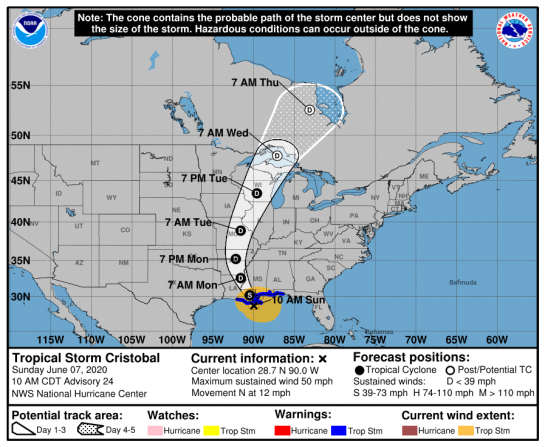
United States/ Canada: Tropical Storm Cristobal 07/1500Z 28.7N 90.0W, moving N ~10.25kt. Wind ~45.89kt. 994mb (NHC FL) – 07 Jun 2020 1520Z (GMT/UTC)

Tropical Storm Cristobal

…CRISTOBAL MOVING CLOSER TO SOUTHEASTERN LOUISIANA…
…HEAVY RAINFALL AND STORM SURGE EXPECTED FROM SOUTHEASTERN
LOUISIANA EASTWARD TO THE FLORIDA PANHANDLE…

A Storm Surge Warning is in effect for…
* Mouth of the Mississippi River to Ocean Springs Mississippi
* Lake Borgne

A Storm Surge Watch is in effect for…
* East of Morgan City Louisiana to the mouth of the Mississippi
River

A Tropical Storm Warning is in effect for…
* Intracoastal City Louisiana to the Okaloosa/Walton County
Florida line
* Lake Pontchartrain and Lake Maurepas

Tornado Watch for portions of
Coastal Alabama
Coastal Mississippi
Coastal Waters

National Hurricane Center FL

145206_5day_cone_no_line_and_wind


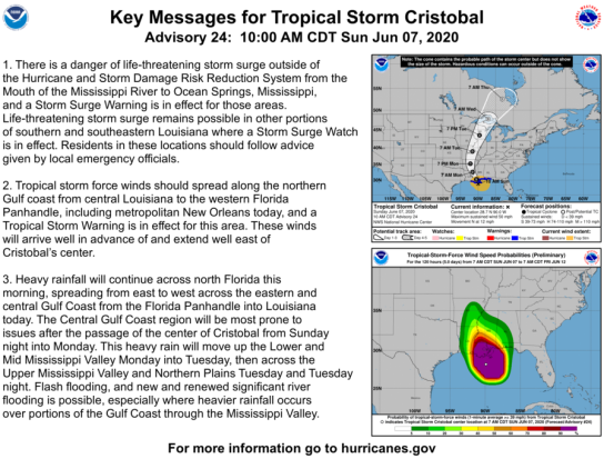
Key Msgs

000
WTNT33 KNHC 071447
TCPAT3

BULLETIN
Tropical Storm Cristobal Advisory Number 24
NWS National Hurricane Center Miami FL AL032020
1000 AM CDT Sun Jun 07 2020

…CRISTOBAL MOVING CLOSER TO SOUTHEASTERN LOUISIANA…
…HEAVY RAINFALL AND STORM SURGE EXPECTED FROM SOUTHEASTERN
LOUISIANA EASTWARD TO THE FLORIDA PANHANDLE…
SUMMARY OF 1000 AM CDT…1500 UTC…INFORMATION
———————————————–
LOCATION…28.7N 90.0W
ABOUT 90 MI…145 KM S OF NEW ORLEANS LOUISIANA
MAXIMUM SUSTAINED WINDS…50 MPH…85 KM/H
PRESENT MOVEMENT…N OR 355 DEGREES AT 12 MPH…19 KM/H
MINIMUM CENTRAL PRESSURE...994 MB…29.36 INCHES
WATCHES AND WARNINGS
——————–
CHANGES WITH THIS ADVISORY:

None.

SUMMARY OF WATCHES AND WARNINGS IN EFFECT:

A Storm Surge Warning is in effect for…
* Mouth of the Mississippi River to Ocean Springs Mississippi
* Lake Borgne

A Storm Surge Watch is in effect for…
* East of Morgan City Louisiana to the mouth of the Mississippi
River

A Tropical Storm Warning is in effect for…
* Intracoastal City Louisiana to the Okaloosa/Walton County
Florida line
* Lake Pontchartrain and Lake Maurepas

A Storm Surge Warning means there is a danger of life-threatening
inundation, from rising water moving inland from the coastline,
during the next 36 hours in the indicated locations. For a depiction
of areas at risk, please see the National Weather Service Storm
Surge Watch/Warning Graphic, available at hurricanes.gov. This is a
life-threatening situation. Persons located within these areas
should take all necessary actions to protect life and property from
rising water and the potential for other dangerous conditions.
Promptly follow evacuation and other instructions from local
officials.

A Storm Surge Watch means there is a possibility of life-
threatening inundation, from rising water moving inland from the
coastline, in the indicated locations during the next 48 hours.

A Tropical Storm Warning means that tropical storm conditions are
expected somewhere within the warning area within the next 24 hours.

For storm information specific to your area, including possible
inland watches and warnings, please monitor products issued by your
local National Weather Service forecast office.
DISCUSSION AND OUTLOOK
———————-
At 1000 AM CDT (1500 UTC), the center of Tropical Storm Cristobal
was located near latitude 28.7 North, longitude 90.0 West. Cristobal
is moving toward the north near 12 mph (19 km/h), and this general
motion is expected to continue today, followed by a gradual turn
toward the north-northwest late today or tonight. On the forecast
track, the center of Cristobal will approach the northern Gulf of
Mexico coast this afternoon, then move inland across Louisiana late
today through Monday morning, and northward across Arkansas and
Missouri Monday afternoon into Tuesday.

Data from an Air Force Reserve reconnaissance aircraft and NOAA
Doppler weather radars indicate that maximum sustained winds remain
near 50 mph (85 km/h) with higher gusts. Little change in strength
is forecast before landfall. Gradual weakening will begin once
Cristobal moves inland.

Tropical-storm-force winds extend outward up to 205 miles (335 km),
mainly to the east of the center. A Weatherflow site at Bayou
Bienvenue, Louisiana, recently measured a sustained wind of 37 mph
(60 km/h) and a gust to 47 mph (76 km/h).

The estimated minimum central pressure is 994 mb (29.36 inches).
HAZARDS AFFECTING LAND
———————-
Key messages for Cristobal can be found in the Tropical Cyclone
Discussion under AWIPS header MIATCDAT3, WMO header WTNT43 KNHC, and
on the web at http://www.hurricanes.gov/text/MIATCDAT3.shtml

STORM SURGE: The combination of a dangerous storm surge and the
tide will cause normally dry areas near the coast to be flooded by
rising waters moving inland from the shoreline. The water could
reach the following heights above ground somewhere in the indicated
areas if the peak surge occurs at the time of high tide…

Mouth of the Mississippi River to Ocean Springs MS including Lake
Borgne…3-5 ft
Morgan City LA to Mouth of the Mississippi River…2-4 ft
Ocean Springs MS to Marco Island FL including Mobile Bay, Pensacola
Bay, and Tampa Bay…1-3 ft

The deepest water will occur along the immediate coast in areas of
onshore winds and will likely extend along the coast well to the
east of the center. Surge-related flooding depends on the relative
timing of the surge and the tidal cycle, and can vary greatly over
short distances. For information specific to your area, please see
products issued by your local National Weather Service forecast
office.

WIND: Tropical storm conditions are expected within the Tropical
Storm Warning area along the northern Gulf coast through tonight.

RAINFALL: Cristobal is expected to produce total rainfall
accumulations of 4 to 8 inches across portions of the central Gulf
Coast into the Lower Mississippi Valley, with isolated amounts to
12 inches. Rainfall totals of 2 to 4 inches with local amounts to
6 inches are expected across portions of the eastern Gulf Coast,
along with the Mid to Upper Mississippi Valley and Northern Plains
near and in advance of Cristobal. This rainfall will likely lead
to flash flooding and widespread flooding on smaller streams across
portions of the central Gulf Coast into the Lower Mississippi
Valley. New and renewed significant river flooding is possible
along the central Gulf Coast and into the Mississippi Valley.

TORNADOES: A few tornadoes are possible today and tonight across
eastern Louisiana, southern Mississippi, southern Alabama, and
northern Florida.

SURF: Swells generated by Cristobal will affect portions of the
northern and eastern Gulf coast during the next couple of days.
These swells are likely to cause life-threatening surf and rip
current conditions. Please consult products from your local
weather office.
NEXT ADVISORY
————-
Next intermediate advisory at 100 PM CDT.
Next complete advisory at 400 PM CDT.

$$
Forecaster Stewart


TORNADOES

CANADA


https://weather.gc.ca/warnings/index_e.htmlhttps://weather.gc.ca/warnings/index_e.html


TROPICAL STORM RISK
University College London, UK

N Atlantic: Storm Alert issued at 7 Jun, 2020 15:00 GMT

Tropical Storm CRISTOBAL is currently located near 28.7 N 90.0 W with maximum 1-min sustained winds of 45kts (52 mph). CRISTOBAL is forecast to affect land to the following likelihood(s) at the given lead time(s):
Yellow Alert Country(s) or Province(s)
    the United States
        probability for TS is 100% currently
Yellow Alert City(s) and Town(s)
    New Orleans (30.0 N, 90.1 W)
        probability for TS is 100% currently
    Mobile (30.7 N, 88.1 W)
        probability for TS is 95% within 9 hours
    Baton Rouge (30.5 N, 91.2 W)
        probability for TS is 95% within 9 hours
    Jackson (32.3 N, 90.2 W)
        probability for TS is 90% within 9 hours
    Meridian (32.4 N, 88.7 W)
        probability for TS is 85% within 9 hours

Green Alert Country(s) or Province(s)
    Canada
        probability for TS is 40% in about 69 hours
Green Alert City(s) and Town(s)
    Pensacola (30.7 N, 87.0 W)
        probability for TS is 45% within 9 hours
    Memphis (35.1 N, 90.0 W)
        probability for TS is 40% in about 21 hours

Note that
Yellow Alert (Elevated) is CAT 1 or above to between 10% and 30% probability, or TS to above 50% probability.
Green Alert (Low) is TS to between 31% and 50% probability.
CAT 1 means Hurricane strength winds of at least 74 mph, 119 km/h or 64 knots 1-min sustained.
TS means Tropical Storm strength winds of at least 39 mph, 63 km/h or 34 knots 1-min sustained.


For graphical forecast information and further details please visit http://www.tropicalstormrisk.com/


Current probability of tropical storm winds


MARITIME/SHIPPING

WTNT23 KNHC 071445
TCMAT3

TROPICAL STORM CRISTOBAL FORECAST/ADVISORY NUMBER 24
NWS NATIONAL HURRICANE CENTER MIAMI FL AL032020
1500 UTC SUN JUN 07 2020

CHANGES IN WATCHES AND WARNINGS WITH THIS ADVISORY…

NONE.

SUMMARY OF WATCHES AND WARNINGS IN EFFECT…

A STORM SURGE WARNING IS IN EFFECT FOR…
* MOUTH OF THE MISSISSIPPI RIVER TO OCEAN SPRINGS MISSISSIPPI
* LAKE BORGNE

A STORM SURGE WATCH IS IN EFFECT FOR…
* EAST OF MORGAN CITY LOUISIANA TO THE MOUTH OF THE MISSISSIPPI
RIVER

A TROPICAL STORM WARNING IS IN EFFECT FOR…
* INTRACOASTAL CITY LOUISIANA TO THE OKALOOSA/WALTON COUNTY
FLORIDA LINE
* LAKE PONTCHARTRAIN AND LAKE MAUREPAS

A STORM SURGE WARNING MEANS THERE IS A DANGER OF LIFE-THREATENING
INUNDATION…FROM RISING WATER MOVING INLAND FROM THE
COASTLINE…DURING THE NEXT 36 HOURS IN THE INDICATED LOCATIONS.
FOR A DEPICTION OF AREAS AT RISK…PLEASE SEE THE NATIONAL WEATHER
SERVICE STORM SURGE WATCH/WARNING GRAPHIC…AVAILABLE AT
HURRICANES.GOV. THIS IS A LIFE-THREATENING SITUATION. PERSONS
LOCATED WITHIN THESE AREAS SHOULD TAKE ALL NECESSARY ACTIONS TO
PROTECT LIFE AND PROPERTY FROM RISING WATER AND THE POTENTIAL FOR
OTHER DANGEROUS CONDITIONS. PROMPTLY FOLLOW EVACUATION AND OTHER
INSTRUCTIONS FROM LOCAL OFFICIALS.

A STORM SURGE WATCH MEANS THERE IS A POSSIBILITY OF LIFE-
THREATENING INUNDATION…FROM RISING WATER MOVING INLAND FROM THE
COASTLINE…IN THE INDICATED LOCATIONS DURING THE NEXT 48 HOURS.

A TROPICAL STORM WARNING MEANS THAT TROPICAL STORM CONDITIONS ARE
EXPECTED SOMEWHERE WITHIN THE WARNING AREA WITHIN THE NEXT 24 HOURS.

TROPICAL STORM CENTER LOCATED NEAR 28.7N 90.0W AT 07/1500Z
POSITION ACCURATE WITHIN 30 NM

PRESENT MOVEMENT TOWARD THE NORTH OR 355 DEGREES AT 10 KT

ESTIMATED MINIMUM CENTRAL PRESSURE 994 MB
MAX SUSTAINED WINDS 45 KT WITH GUSTS TO 55 KT.
34 KT…….180NE 180SE 90SW 140NW.
12 FT SEAS..300NE 330SE 150SW 150NW.
WINDS AND SEAS VARY GREATLY IN EACH QUADRANT. RADII IN NAUTICAL
MILES ARE THE LARGEST RADII EXPECTED ANYWHERE IN THAT QUADRANT.

REPEAT…CENTER LOCATED NEAR 28.7N 90.0W AT 07/1500Z
AT 07/1200Z CENTER WAS LOCATED NEAR 28.2N 89.9W

FORECAST VALID 08/0000Z 30.2N 90.5W…INLAND
MAX WIND 45 KT…GUSTS 55 KT.
34 KT…180NE 170SE 50SW 70NW.

FORECAST VALID 08/1200Z 32.6N 91.6W…INLAND
MAX WIND 30 KT…GUSTS 40 KT.

FORECAST VALID 09/0000Z 35.2N 92.2W…INLAND
MAX WIND 25 KT…GUSTS 35 KT.

FORECAST VALID 09/1200Z 38.9N 91.6W…INLAND
MAX WIND 25 KT…GUSTS 35 KT.

FORECAST VALID 10/0000Z 43.5N 89.6W…INLAND
MAX WIND 25 KT…GUSTS 35 KT.

FORECAST VALID 10/1200Z 47.8N 87.1W…POST-TROP/EXTRATROP
MAX WIND 30 KT…GUSTS 40 KT.

EXTENDED OUTLOOK. NOTE…ERRORS FOR TRACK HAVE AVERAGED NEAR 150 NM
ON DAY 4 AND 175 NM ON DAY 5…AND FOR INTENSITY NEAR 15 KT EACH DAY

OUTLOOK VALID 11/1200Z 52.6N 83.1W…POST-TROP/EXTRATROP
MAX WIND 30 KT…GUSTS 40 KT.

OUTLOOK VALID 12/1200Z…DISSIPATED

REQUEST FOR 3 HOURLY SHIP REPORTS WITHIN 300 MILES OF 28.7N 90.0W

INTERMEDIATE PUBLIC ADVISORY…WTNT33 KNHC/MIATCPAT3…AT 07/1800Z

NEXT ADVISORY AT 07/2100Z

$$
FORECASTER STEWART

=========================================================================

Do not use any information on this site for life or death decisions. All information is intended as supplementary to official sources. Kindly refer to your country’s official weather agency/government website for local warnings, advisories and bulletins.


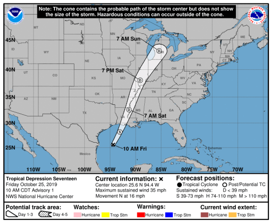
US/ Gulf of Mexico: Tropical Depression SEVENTEEN 17L 25/1500Z 25.6N 94.4W, moving N ~14.03kt 1006 mb (NHC FL) – Published 25 Oct 2019 1930Z (GMT/UTC)

Tropical Depression SEVENTEEN 17L

(Future Cyclone OLGA)

…TROPICAL DEPRESSION FORMS IN THE WESTERN GULF OF MEXICO…
…EXPECTED TO BECOME A GALE-FORCE POST-TROPICAL LOW TONIGHT…NHC FL


NATIONAL HURRICANE CENTER FL

143243_5day_cone_no_line_and_wind

000
WTNT32 KNHC 251431
TCPAT2

BULLETIN
Tropical Depression Seventeen Advisory Number 1
NWS National Hurricane Center Miami FL AL172019
1000 AM CDT Fri Oct 25 2019

…TROPICAL DEPRESSION FORMS IN THE WESTERN GULF OF MEXICO…
…EXPECTED TO BECOME A GALE-FORCE POST-TROPICAL LOW TONIGHT…
SUMMARY OF 1000 AM CDT…1500 UTC…INFORMATION
———————————————–
LOCATION…25.6N 94.4W
ABOUT 320 MI…515 KM SSW OF LAKE CHARLES LOUISIANA
MAXIMUM SUSTAINED WINDS…35 MPH…55 KM/H
PRESENT MOVEMENT…N OR 10 DEGREES AT 16 MPH…26 KM/H
MINIMUM CENTRAL PRESSURE…1006 MB…29.71 INCHES
WATCHES AND WARNINGS
——————–
There are no coastal tropical cyclone watches or warnings in
effect.

Please see High Seas Forecasts issued by the National Weather
Service and products from local National Weather Service forecast
offices for information on the non-tropical watches and warnings
associated with this system.
DISCUSSION AND OUTLOOK
———————-
At 1000 AM CDT (1500 UTC), the center of Tropical Depression
Seventeen was located near latitude 25.6 North, longitude 94.4 West.
The depression is moving toward the north near 16 mph (26 km/h). A
motion toward the north-northeast at a faster forward speed is
expected this afternoon through Sunday. On the forecast track, the
center of the cyclone should move across the northwestern Gulf of
Mexico this afternoon and then move over the northern Gulf coast
tonight or Saturday morning.

Maximum sustained winds are near 35 mph (55 km/h) with higher gusts.
Some strengthening is expected today, and the depression could
become a tropical storm this afternoon. The cyclone is then
expected to merge with a cold front and become a post-tropical low
with gale-force winds tonight before the center reaches the Gulf
coast. An Air Force Reserve Hurricane Hunter aircraft is scheduled
to investigate the depression this afternoon.

The estimated minimum central pressure is 1006 mb (29.71 inches).
HAZARDS AFFECTING LAND
———————-
WIND: Gale-force winds associated with this system should spread
over portions of the northern Gulf coast tonight and Saturday
morning.

RAINFALL: The depression and rainfall ahead of the system along and
north of the frontal boundary across the Central Gulf coast is
expected to produce total rainfall accumulations of 2 to 4 inches
with maximum totals of 8 inches across the Central Gulf coast into
the Lower Mississippi Valley through Saturday morning. These rains
may produce flash flooding across the Central Gulf coast into the
Lower Mississippi Valley.

COASTAL FLOODING: Above-normal tides and associated coastal
flooding are possible across portions of the northern Gulf coast.
Please see products from local National Weather Service forecast
offices for additional information.

TORNADOES: A couple tornadoes are possible through tonight across
southeast portions of Louisiana and Mississippi into southwest
Alabama.
NEXT ADVISORY
————-
Next complete advisory at 400 PM CDT.

$$
Forecaster Beven


TROPICAL STORM RISK
University College London, UK

N Atlantic: Storm Alert issued at 18 Oct, 2019 9:00 GMT

N Atlantic: Storm Alert issued at 25 Oct, 2019 15:00 GMT

Tropical Depression AL17 is currently located near 25.6 N 94.4 W with maximum 1-min sustained winds of 30kts (35 mph). AL17 is forecast to affect land to the following likelihood(s) at the given lead time(s):
Yellow Alert Country(s) or Province(s)
    the United States
        probability for TS is 70% in about 21 hours

Green Alert City(s) and Town(s)
    Baton Rouge (30.5 N, 91.2 W)
        probability for TS is 40% in about 21 hours
    Galveston (29.4 N, 94.8 W)
        probability for TS is 35% in about 21 hours

Note that
Yellow Alert (Elevated) is CAT 1 or above to between 10% and 30% probability, or TS to above 50% probability.
Green Alert (Low) is TS to between 31% and 50% probability.
CAT 1 means Hurricane strength winds of at least 74 mph, 119 km/h or 64 knots 1-min sustained.
TS means Tropical Storm strength winds of at least 39 mph, 63 km/h or 34 knots 1-min sustained.

For graphical forecast information and further details please visit http://www.tropicalstormrisk.com/


Current probability of tropical storm winds


MARITIME/SHIPPING

WTNT22 KNHC 251431
TCMAT2

TROPICAL DEPRESSION SEVENTEEN FORECAST/ADVISORY NUMBER 1
NWS NATIONAL HURRICANE CENTER MIAMI FL AL172019
1500 UTC FRI OCT 25 2019

THERE ARE NO COASTAL TROPICAL CYCLONE WATCHES OR WARNINGS IN
EFFECT.

PLEASE SEE HIGH SEAS FORECASTS ISSUED BY THE NATIONAL WEATHER
SERVICE AND PRODUCTS FROM LOCAL NATIONAL WEATHER SERVICE FORECAST
OFFICES FOR INFORMATION ON THE NON-TROPICAL WATCHES AND WARNINGS
ASSOCIATED WITH THIS SYSTEM.

TROPICAL DEPRESSION CENTER LOCATED NEAR 25.6N 94.4W AT 25/1500Z
POSITION ACCURATE WITHIN 20 NM

PRESENT MOVEMENT TOWARD THE NORTH OR 10 DEGREES AT 14 KT

ESTIMATED MINIMUM CENTRAL PRESSURE 1006 MB
MAX SUSTAINED WINDS 30 KT WITH GUSTS TO 40 KT.
WINDS AND SEAS VARY GREATLY IN EACH QUADRANT. RADII IN NAUTICAL
MILES ARE THE LARGEST RADII EXPECTED ANYWHERE IN THAT QUADRANT.

REPEAT…CENTER LOCATED NEAR 25.6N 94.4W AT 25/1500Z
AT 25/1200Z CENTER WAS LOCATED NEAR 24.7N 94.8W

FORECAST VALID 26/0000Z 28.2N 93.1W…POST-TROP/EXTRATROP
MAX WIND 35 KT…GUSTS 45 KT.
34 KT… 80NE 0SE 80SW 80NW.

FORECAST VALID 26/1200Z 32.6N 91.3W…POST-TROP/EXTRATROP
MAX WIND 30 KT…GUSTS 40 KT.

FORECAST VALID 27/0000Z 38.1N 89.1W…POST-TROP/EXTRATROP
MAX WIND 25 KT…GUSTS 35 KT.

FORECAST VALID 27/1200Z 43.2N 85.4W…POST-TROP/EXTRATROP
MAX WIND 20 KT…GUSTS 30 KT.

FORECAST VALID 28/1200Z…DISSIPATED

REQUEST FOR 3 HOURLY SHIP REPORTS WITHIN 300 MILES OF 25.6N 94.4W

NEXT ADVISORY AT 25/2100Z

$$
FORECASTER BEVEN

FZNT01 KWBC 251604
HSFAT1

HIGH SEAS FORECAST FOR METAREA IV
NWS OCEAN PREDICTION CENTER WASHINGTON DC
1630 UTC FRI OCT 25 2019

CCODE/1:31:04:01:00/AOE/NWS/CCODE
SUPERSEDED BY NEXT ISSUANCE IN 6 HOURS

SEAS GIVEN AS SIGNIFICANT WAVE HEIGHT…WHICH IS THE AVERAGE
HEIGHT OF THE HIGHEST 1/3 OF THE WAVES. INDIVIDUAL WAVES MAY
BE MORE THAN TWICE THE SIGNIFICANT WAVE HEIGHT.

METAREA IV BULLETIN WILL ONLY BE BROADCAST FROM THE INMARSAT
AOE SATELLITE. PLEASE ENSURE YOUR RECEIVER IS POINTED
CORRECTLY.

ONLY YOU KNOW THE WEATHER AT YOUR POSITION. REPORT IT TO THE
NATIONAL WEATHER SERVICE. EMAIL US AT
VOSOPS@NOAA.GOV(LOWERCASE).

FOR INFORMATION ON ATLANTIC ICEBERGS SEE INFORMATION FROM NORTH
ATLANTIC ICE SERVICE AT HTTPS://OCEAN.WEATHER.GOV/ATL_TAB.SHTML
(LOWERCASE EXCEPT CAPITAL A IN ATL).

SECURITE

NORTH ATLANTIC NORTH OF 31N TO 67N AND WEST OF 35W

SYNOPSIS VALID 1200 UTC OCT 25.
24 HOUR FORECAST VALID 1200 UTC OCT 26.
48 HOUR FORECAST VALID 1200 UTC OCT 27.

.WARNINGS.

…STORM WARNING…
.LOW E OF AREA 36N33W 992 MB MOVING E 10 KT. OVER FORECAST
WATERS FROM 32N TO 42N BETWEEN 35W AND 40W WINDS 30 TO 45 KT.
SEAS 16 TO 28 FT. ELSEWHERE FROM 31N TO 47N BETWEEN 35W AND 55W
WINDS 20 TO 30 KT. SEAS 8 TO 16 FT.
.24 HOUR FORECAST LOW E OF AREA 36N28W 999 MB. NEW LOW 38N53W
1008 MB RAPDILY INTENSIFYING. FROM 31N TO 38N BETWEEN 35W AND
38W N WINDS 25 KT. SEAS 14 TO 18 FT IN N SWELL. ELSEWHERE FROM
31N TO 42N BETWEEN 35W AND 55W WINDS LESS THAN 25 KT. SEAS 8 TO
14 FT IN N SWELL.
.48 HOUR FORECAST FIRST LOW WELL E OF AREA 41N23W 1000 MB.
SECOND LOW 41N48W 978 MB. WITHIN 180 NM SW SEMICIRCLE WINDS 40
TO 50 KT. SEAS 12 TO 14 FT. ELSEWHERE FROM 31N TO 43N BETWEEN
35W AND 62W WINDS 25 TO 40 KT. SEAS 8 TO 12 FT.

…GALE WARNING…
.FROM 50N TO 55N BETWEEN 45W AND 50W SE TO S WINDS 20 TO 30 KT.
SEAS 9 TO 11 FT. ELSEWHERE FROM 47N TO 55N BETWEEN 35W AND 52W
WINDS LESS THAN 25 KT. SEAS 8 TO 9 FT IN MIXED SWELL.
.24 HOUR FORECAST NEW LOW 53N43W 1016 MB. WITHIN 120 NM NE
QUADRANT AND FROM 45N TO 50N BETWEEN 37W AND 40W WINDS 20 TO 30
KT. SEAS TO 9 FT. ELSEWHERE FROM 42N TO 58N WINDS LESS THAN 25
KT. SEAS TO 9 FT IN MIXED SWELL.
.48 HOUR FORECAST COMPLEX LOW MEAN CENTER 55N43W 1004 MB. WITHIN
180 NM NE QUADRANT WINDS 25 TO 35 KT. SEAS 10 TO 15 FT.
ELSEWHERE FROM 43N TO 60N BETWEEN 35W AND 47W WINDS 20 TO 30 KT.
SEAS 8 TO 10 FT.

…GALE WARNING…
.LOW 59N58W 1003 MB MOVING NW 20 KT. WITHIN 270 NM N OF LINE
FROM 65N63W TO 55N48W SE WINDS 25 TO 40 KT. SEAS 8 TO 18
FT…HIGHEST NEAR 67N57W.
.24 HOUR FORECAST LOW W OF AREA 65N66W 1006 MB. WITHIN 120 NM N
OF LINE FROM 67N61W TO 60N50W SE WINDS 25 KT. SEAS 10 TO 15 FT.
ELSEWHERE N OF 60N BETWEEN 47W AND 63W WINDS LESS THAN 25 KT.
SEAS 8 TO 10 FT IN SE SWELL.
.48 HOUR FORECAST LOW N OF AREA. CONDITIONS DIMINISHED.

.SYNOPSIS AND FORECAST.

.24 HOUR FORECAST FROM 55N TO 60N W OF 57W N WINDS 20 TO 30 KT.
SEAS TO 8 FT.
.48 HOUR FORECAST FROM 50N TO 55N W OF 54W NW TO N WINDS 20 TO
30 KT. SEAS 8 FT.

.DENSE FOG. 24 HOUR FORECAST VSBY OCCASIONALLY LESS THAN 1 NM
OVER FORECAST WATERS FROM 55N TO 62N BETWEEN 55W AND 60W.
.48 HOUR FORECAST DENSE FOG FROM 50N TO 55N BETWEEN 52W AND 55W.

.HIGH 39N67W 1028 MB MOVING E 15 KT.
.24 HOUR FORECAST HIGH 35N61W 1021 MB.
.48 HOUR FORECAST HIGH DISSIPATED.

.HIGH 63N39W 1026 MB MOVING SE 10 KT.
.24 HOUR FORECAST HIGH E OF AREA 60N33W 1022 MB.
.48 HOUR FORECAST HIGH E OF AREA.

.24 HOUR FORECAST NEW HIGH 31N54W 1022 MB.
.48 HOUR FORECAST HIGH DISSIPATED.

.FORECASTER CHRISTENSEN. OCEAN PREDICTION CENTER.

NATIONAL HURRICANE CENTER MIAMI FL

ATLANTIC FROM 07N TO 31N W OF 35W INCLUDING CARIBBEAN SEA AND
GULF OF MEXICO

SYNOPSIS VALID 1200 UTC FRI OCT 25.
24 HOUR FORECAST VALID 1200 UTC SAT OCT 26.
48 HOUR FORECAST VALID 1200 UTC SUN OCT 27.

.WARNINGS.

…GULF OF MEXICO GALE WARNING…
.COLD FRONT FROM 30N94.5W TO 23N96W TO 22N98W. W OF FRONT NW TO
N WINDS 25 TO 35 KT. SEAS TO 12 FT. TROPICAL DEPRESSION
SEVENTEEN NEAR 25.6N 94.4W 1006 MB AT 1500 UTC OCT 25 MOVING N
OR 010 DEG AT 14 KT. MAXIMUM SUSTAINED WINDS 30 KT GUSTS 40 KT.
WITHIN 120 NM E AND 45 NM W SEMICIRCLES OF T.D. WINDS 25 TO 30
KT. SEAS 8 TO 10 FT. ELSEWHERE N OF 22.5N BETWEEN 88W AND 95W SE
TO S WINDS 20 TO 25 KT. SEAS TO 9 FT.
.24 HOUR FORECAST COLD FRONT FROM 30N89W TO 18N93W. POST-
TROPICAL EXTRATROPICAL SEVENTEEN INLAND NEAR 32.6N 91.3W.
MAXIMUM SUSTAINED WINDS 30 KT GUSTS 40 KT. S OF 28.5N W OF FRONT
NW TO N WINDS 20 TO 30 KT…HIGHEST S OF 20N. SEAS 8 TO 15
FT…HIGHEST S OF 21N. N OF 28N BETWEEN 86W AND 89W WINDS 20 KT
OR LESS. SEAS TO 8 FT IN S SWELL.
.48 HOUR FORECAST COLD FRONT FROM 30N84.5W TO 18.5N93W. POST-
TROPICAL EXTRATROPICAL SEVENTEEN NEAR 43.2N 85.4W. MAXIMUM
SUSTAINED WINDS 20 KT GUSTS 30 KT. S OF 20N BETWEEN 92.5W AND
94.5W WINDS 20 KT OR LESS. SEAS TO 8 FT IN N SWELL.

.SYNOPSIS AND FORECAST.

.ATLC COLD FRONT FROM 24.5N35W TO 20.5N48W. WITHIN 120 NM SE OF
FRONT E OF 38W SW TO W WINDS 20 TO 25 KT. SEAS TO 10 FT. N OF
28N E OF 46W NW TO N WINDS 20 TO 30 KT…EXCEPT NW TO W WINDS 20
TO 25 KT E OF 38W. SEAS 12 TO 20 FT WITH N SWELL. ELSEWHERE N OF
24N E OF 53W WINDS 20 KT OR LESS. SEAS TO 11 FT IN N SWELL.
.24 HOUR FORECAST COLD FRONT FROM 21.5N35W TO 18.5N43W. N OF 19N
E OF 59W WINDS 20 KT OR LESS. SEAS 8 TO 19 FT IN N TO NE
SWELL…HIGHEST NE PART.
.48 HOUR FORECAST STATIONARY FRONT FROM 21N35W TO 17.5N45W. N OF
12.5N E OF 65W WINDS 20 KT OR LESS. SEAS 8 TO 13 FT IN N TO NE
SWELL.

.REMAINDER OF AREA WINDS 20 KT OR LESS. SEAS LESS THAN 8 FT.

$$
.FORECASTER STRIPLING. NATIONAL HURRICANE CENTER.

===========================================================================================================

Do not use any information on this site for life or death decisions. All information is intended as supplementary to official sources. Kindly refer to your country’s official weather agency/government website for local warnings, advisories and bulletins.


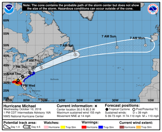
United States: Major Hurricane Michael CAT4 10/1900Z 30.4N 85.3W, moving NNE 15mph/ ~13.03kt 922mb (NHC FL) – Updated 10 Oct 2018 1935Z (GMT/UTC)


MAJOR HURRICANE MICHAEL

Michael is an extremely dangerous category 4 hurricane on the Saffir-Simpson Hurricane Wind Scale.

…MICHAEL INTENSIFIES AS IT MAKES LANDFALL NEAR MEXICO BEACH FLORIDA…
…LIFE-THREATENING STORM SURGE…HURRICANE FORCE WINDS…AND HEAVY
RAINFALL OCCURING OVER THE FLORIDA PANHANDLE… NHC

A Storm Surge Warning is in effect for…
* Okaloosa/Walton County Line Florida to Anclote River Florida

A Storm Surge Watch is in effect for…
* Anclote River Florida to Anna Maria Island Florida, including
Tampa Bay
* Ocracoke Inlet North Carolina to Duck North Carolina

A Hurricane Warning is in effect for…
* Alabama/Florida border to Suwannee River Florida

A Tropical Storm Warning is in effect for…
* Suwanee River Florida to Chassahowitzka Florida
* North of Fernandina Beach Florida to Duck North Carolina
* Pamlico and Albemarle Sounds


National Hurricane Center

152003_5day_cone_no_line_and_wind1

STORM SURGE WARNING GRAPHIC (Link)

TORNADOES (see below)

000
WTNT34 KNHC 101737
TCPAT4

BULLETIN
Hurricane Michael Intermediate Advisory Number 16A
NWS National Hurricane Center Miami FL AL142018
100 PM CDT Wed Oct 10 2018

…MICHAEL INTENSIFIES AS IT MAKES LANDFALL NEAR MEXICO BEACH
FLORIDA…
…LIFE-THREATENING STORM SURGE…HURRICANE FORCE WINDS…AND HEAVY
RAINFALL OCCURING OVER THE FLORIDA PANHANDLE…
SUMMARY OF 100 PM CDT…1800 UTC…INFORMATION
———————————————-
LOCATION…30.0N 85.5W
ABOUT 5 MI…10 KM NW OF MEXICO BEACH FLORIDA
ABOUT 20 MI…30 KM SE OF PANAMA CITY FLORIDA
MAXIMUM SUSTAINED WINDS…155 MPH…250 KM/H
PRESENT MOVEMENT…NNE OR 20 DEGREES AT 14 MPH…22 KM/H
MINIMUM CENTRAL PRESSURE…919 MB…27.41 INCHES
WATCHES AND WARNINGS
——————–
CHANGES WITH THIS ADVISORY:

The Tropical Storm Warning has been discontinued west of the
Alabama/Florida border.

The Tropical Storm Watch along the west coast of Florida has been
discontinued south of Chassahowitzka.

SUMMARY OF WATCHES AND WARNINGS IN EFFECT:

A Storm Surge Warning is in effect for…
* Okaloosa/Walton County Line Florida to Anclote River Florida

A Storm Surge Watch is in effect for…
* Anclote River Florida to Anna Maria Island Florida, including
Tampa Bay
* Ocracoke Inlet North Carolina to Duck North Carolina

A Hurricane Warning is in effect for…
* Alabama/Florida border to Suwannee River Florida

A Tropical Storm Warning is in effect for…
* Suwanee River Florida to Chassahowitzka Florida
* North of Fernandina Beach Florida to Duck North Carolina
* Pamlico and Albemarle Sounds

A Storm Surge Warning means there is a danger of life-threatening
inundation, from rising water moving inland from the coastline. For
a depiction of areas at risk, please see the National Weather
Service Storm Surge Watch/Warning Graphic, available at
hurricanes.gov.

A Hurricane Warning means that hurricane conditions are expected
somewhere within the warning area.

A Tropical Storm Warning means that tropical storm conditions are
expected somewhere within the warning area.

A Storm Surge Watch means there is a possibility of life-
threatening inundation, from rising water moving inland from the
coastline.

Interests elsewhere across the southeastern United States should
monitor the progress of Michael.

For storm information specific to your area, including possible
inland watches and warnings, please monitor products issued by your
local National Weather Service forecast office.
DISCUSSION AND OUTLOOK
———————-
Satellite, aircraft, and radar data indicate that the eye of
Michael is making landfall just northwest of Mexico Beach, Florida.

At 100 PM CDT (1800 UTC), the eye of Hurricane Michael was located
near latitude 30.0 North, longitude 85.5 West. Michael is moving
toward the north-northeast near 14 mph (22 km/h). A turn toward the
northeast is expected this afternoon or tonight. A motion toward
the northeast at a faster forward speed is forecast on Thursday
through Friday night. On the forecast track, the core of Michael
will move inland across the Florida Panhandle this afternoon, and
across southeastern Alabama and southwestern Georgia tonight.
Michael will move northeastward across the southeastern United
States through Thursday night, and then move off the Mid-Atlantic
coast away from the United States on Friday.

Recent data from NOAA and Air Force Reserve Hurricane Hunter
aircraft indicate that maximum sustained winds have increased to
near 155 mph (250 km/h) with higher gusts. Michael is an extremely
dangerous category 4 hurricane on the Saffir-Simpson Hurricane Wind
Scale. Michael should weaken as it crosses the southeastern United
States. Michael is forecast to become a post-tropical cyclone on
Friday, and strengthening is forecast as the system moves over the
western Atlantic.

Hurricane-force winds extend outward up to 45 miles (75 km) from
the center and tropical-storm-force winds extend outward up to 175
miles (280 km). A wind gust of 130 mph (210 mph) was recently
reported at a University of Florida/Weatherflow observing site near
Tyndall Air Force Base before the instrument failed. A wind gust to
129 mph (207 km/h) was reported at the Panama City Airport.

The latest minimum central pressure based on data from an Air Force
Reserve reconnaissance aircraft is 919 mb (27.41 inches).

A minimum pressure of 920 mb was recently reported by a University
of Florida/Weatherflow observing site near Tyndall Air Force Base.
HAZARDS AFFECTING LAND
———————-
STORM SURGE: The combination of a dangerous storm surge and the
tide will cause normally dry areas near the coast to be flooded by
rising waters moving inland from the shoreline. The water has the
potential to reach the following heights above ground if peak surge
occurs at the time of high tide…

Tyndall Air Force Base FL to Aucilla River FL…9-14 ft
Okaloosa/Walton County Line FL to Tyndall Air Force Base FL…6-9 ft
Aucilla River FL to Cedar Key FL…6-9 ft
Cedar Key FL to Chassahowitzka FL…4-6 ft
Chassahowitzka to Anna Maria Island FL including Tampa Bay…2-4 ft
Sound side of the North Carolina Outer Banks from Ocracoke Inlet to
Duck…2-4 ft

Water levels continue to rise quickly along the coast of the Florida
Panhandle. A National Ocean Service water level station at
Apalachicola recently reported over 6.5 feet of inundation above
ground level.

WIND: Tropical storm and hurricane conditions will continue
to spread inland across portions of the Florida Panhandle,
southeastern Alabama and southwestern Georgia this afternoon and
tonight.

With the landfall of Michael’s eye occurring, everyone in the
landfall area is reminded not to venture out into the relative calm
of the eye, as hazardous winds will increase very quickly as the eye
passes!

Tropical storm conditions are expected to spread northward within
the warning area along the southeast U.S. coast beginning tonight
through Friday.

RAINFALL: Michael is expected to produce the following rainfall
amounts through Friday…

Florida Panhandle and Big Bend, southeast Alabama, and portions of
southwest and central Georgia…4 to 8 inches, with isolated maximum
amounts of 12 inches. This rainfall could lead to life-threatening
flash floods.

The remainder of Georgia, the Carolinas, and southern Virginia…3
to 6 inches, with isolated maximum amounts of 8 inches. This
rainfall could lead to life-threatening flash floods.

Florida Peninsula, eastern Mid Atlantic, southern New England
coast…1-3 inches.

SURF: Swells generated by Michael will affect the coasts of the
eastern, northern, and western Gulf of Mexico during the next day
or so. These swells are likely to cause life-threatening surf
and rip current conditions. Please consult products from your local
weather office.

TORNADOES: Tornadoes are possible across parts of the Florida
Panhandle and the northern Florida Peninsula through this afternoon.
This risk will spread northward into parts of Georgia and southern
South Carolina this afternoon and tonight.
NEXT ADVISORY
————-
Next complete advisory at 400 PM CDT.

$$
Forecaster Brown

000
WTNT34 KNHC 100848
TCPAT4

000
WTNT64 KNHC 101854
TCUAT4

Hurricane Michael Tropical Cyclone Update
NWS National Hurricane Center Miami FL AL142018
200 PM CDT Wed Oct 10 2018

…2 PM CDT POSITION UPDATE…
…EYE OF MICHAEL MOVING INLAND OVER THE FLORIDA PANHANDLE EAST
OF PANAMA CITY…
…LIFE THREATENING STORM SURGE AND CATASTROPHIC WINDS CONTINUE…

Radar data indicate that the eye of Michael is moving inland over
portions of Bay and Calhoun counties in the Florida Panhandle.
Everyone in these areas is reminded not to venture out into the
relative calm of the eye, as hazardous winds will increase very
quickly as the eye passes!

Recently reported wind gusts include:

Tyndall Air Force Base: 119 mph (191 km/h)
Florida State University Panama City Campus: 116 mph (187 km/h)
University of Florida/Weatherflow Mexico Beach: 104 mph (167 km/h)
Panama City Treatment Plant: 94 mph (151 km/h)
Panama City Beach National Ocean Service: 78 mph (126 km/h)

Dangerous storm surge continues along the coast of the Florida
Panhandle. A National Ocean Service water level station at
Apalachicola recently reported over 7.7 feet of inundation above
ground level.
SUMMARY OF 200 PM CDT…1900 UTC…INFORMATION
———————————————–
LOCATION…30.4N 85.3W
ABOUT 30 MI…45 KM ENE OF PANAMA CITY FLORIDA
ABOUT 60 MI…95 KM W OF TALLAHASSEE FLORIDA
MAXIMUM SUSTAINED WINDS…150 MPH…240 KM/H
PRESENT MOVEMENT…NNE OR 25 DEGREES AT 15 MPH…24 KM/H
MINIMUM CENTRAL PRESSURE…922 MB…27.22 INCHES

$$
Forecaster Brennan

SPC

TORNADOES


Mesoscale Discussion 1559
NWS Storm Prediction Center Norman OK
1229 PM CDT Wed Oct 10 2018

Areas affected…Portions of central and southern GA…north
FL…and southern SC

Concerning…Severe potential…Tornado Watch likely

Valid 101729Z – 102030Z

Probability of Watch Issuance…95 percent

SUMMARY…A tornado watch will be issued by mid afternoon across
portions of central and southeast Georgia, and perhaps including
parts of north Florida and southern South Carolina. A tornado
threat will spread to the northeast as Hurricane Michael tracks
toward southwest Georgia by early evening, after making landfall
early this afternoon.

DISCUSSION…Trends in mosaic radar imagery suggest a new outer rain
band may be developing across southeast into south-central GA (from
approximately 25 WSW KSSI to 25 WSW KMCN). The combination of
high-moisture-content air (surface dew points in the middle 70s) and
surface heating, given the presence of filtered sunshine through
high thin cirrus on the northeast periphery of Michael, is resulting
in moderate instability. Meanwhile, trends in low-level shear per
VAD profile at Valdosta, GA adjusted for storm motions of embedded
cells in the rain bands indicated steady strengthening, with 0-1 km
SRH approaching 300 m2/s2 and 0-1 km shear around 40 kt. This
strengthening trend is expected to persist through the afternoon and
evening and expand northward and east some across central and
eastern GA into adjacent southern SC, and perhaps north FL, as
Michael tracks toward southwest GA. This high low-level shear
environment favors an increasing tornado threat and the need for a
tornado watch to the north and northeast of WW 406.

..Peters/Guyer.. 10/10/2018

…Please see http://www.spc.noaa.gov for graphic product…

ATTN…WFO…CHS…CAE…JAX…FFC…TAE…BMX…

LAT…LON 31888448 31508509 33078472 33558396 33538277 33418140
33398098 32528062 31678085 30768128 30208157 29938224
29858269 30928290 31848305 31888448

TROPICAL STORM RISK (TSR)

N Atlantic: Storm Alert issued at 10 Oct, 2018 17:00 GMT

Intense Hurricane MICHAEL is currently located near 29.9 N 85.7 W with maximum 1-min sustained winds of 130 kts (150 mph). MICHAEL is a category 4 storm on the Saffir Simpson Hurricane Wind Scale. MICHAEL is forecast to affect land to the following likelihood(s) at the given lead time(s):
Red Alert Country(s) or Province(s)
    the United States
        probability for CAT 1 or above is 100% currently
        probability for TS is 100% currently
Red Alert City(s) and Town(s)
    Tallahassee (30.4 N, 84.3 W)
        probability for CAT 1 or above is 60% within 7 hours
        probability for TS is 100% currently

Yellow Alert Country(s) or Province(s)
    Canada
        probability for TS is 70% in about 67 hours
Yellow Alert City(s) and Town(s)
    Pensacola (30.7 N, 87.0 W)
        probability for TS is 95% currently
    Wilmington (34.2 N, 77.9 W)
        probability for TS is 75% in about 31 hours
    Columbia (34.0 N, 81.0 W)
        probability for TS is 75% in about 31 hours
    Myrtle Beach (33.7 N, 79.1 W)
        probability for TS is 75% in about 31 hours
    Charleston (32.9 N, 80.0 W)
        probability for TS is 75% in about 31 hours
    Norfolk (36.9 N, 76.2 W)
        probability for TS is 75% in about 43 hours
    Kitty Hawk (36.1 N, 75.7 W)
        probability for TS is 75% in about 43 hours
    Hatteras (35.2 N, 75.6 W)
        probability for TS is 75% in about 43 hours
    Savannah (32.0 N, 81.0 W)
        probability for TS is 70% in about 19 hours
    Raleigh (35.8 N, 78.6 W)
        probability for TS is 70% in about 31 hours
    Capeville (37.2 N, 75.9 W)
        probability for TS is 70% in about 43 hours
    Montgomery (32.4 N, 86.3 W)
        probability for TS is 65% within 7 hours
    Charlotte (35.2 N, 80.8 W)
        probability for TS is 65% in about 31 hours
    Salisbury (38.3 N, 75.6 W)
        probability for TS is 65% in about 43 hours
    Atlantic City (39.0 N, 74.8 W)
        probability for TS is 60% in about 43 hours
    Chatham (41.7 N, 70.1 W)
        probability for TS is 60% in about 67 hours
    Atlanta (33.8 N, 84.4 W)
        probability for TS is 55% in about 19 hours
    Richmond (37.5 N, 77.5 W)
        probability for TS is 55% in about 43 hours
    St John’s (47.5 N, 52.7 W)
        probability for TS is 55% in about 67 hours

Green Alert Country(s) or Province(s)
    St. Pierre and Miquelon
        probability for TS is 50% in about 67 hours
Green Alert City(s) and Town(s)
    Jacksonville (30.3 N, 81.7 W)
        probability for TS is 50% in about 19 hours
    Fredericksburg (38.2 N, 77.5 W)
        probability for TS is 45% in about 43 hours
    Montauk (41.0 N, 72.2 W)
        probability for TS is 45% in about 43 hours
    Belmar (40.1 N, 74.1 W)
        probability for TS is 45% in about 43 hours
    Sydney (46.1 N, 60.1 W)
        probability for TS is 45% in about 67 hours
    Halifax (44.6 N, 63.6 W)
        probability for TS is 45% in about 67 hours
    Philadelphia (39.9 N, 75.2 W)
        probability for TS is 40% in about 43 hours
    Baltimore (39.5 N, 76.0 W)
        probability for TS is 40% in about 43 hours
    Boston (42.3 N, 71.0 W)
        probability for TS is 40% in about 67 hours
    Roanoke (37.0 N, 80.0 W)
        probability for TS is 35% in about 31 hours
    Washington D.C. (38.9 N, 77.0 W)
        probability for TS is 35% in about 43 hours
    Siasconset (41.2 N, 70.2 W)
        probability for TS is 35% in about 43 hours
    New York (40.7 N, 73.9 W)
        probability for TS is 35% in about 43 hours

Note that
Red Alert (Severe) is CAT 1 or above to between 31% and 100% probability.
Yellow Alert (Elevated) is CAT 1 or above to between 10% and 30% probability, or TS to above 50% probability.
Green Alert (Low) is TS to between 31% and 50% probability.
CAT 1 means Hurricane strength winds of at least 74 mph, 119 km/h or 64 knots 1-min sustained.
TS means Tropical Storm strength winds of at least 39 mph, 63 km/h or 34 knots 1-min sustained.


For graphical forecast information and further details please visit http://www.tropicalstormrisk.com/


Current probability of tropical storm winds


Current probability of Cat 1 or above winds


OTHER

Contact Numbers


MARITIME/SHIPPING

000
FZNT24 KNHC 101452
OFFNT4

Offshore Waters Forecast for the Gulf of Mexico
NWS National Hurricane Center Miami, FL
1052 AM EDT Wed Oct 10 2018

Offshore Waters Forecast for the Gulf of Mexico

Seas given as significant wave height, which is the average
height of the highest 1/3 of the waves. Individual waves may be
more than twice the significant wave height.

GMZ001-110300-
Synopsis for the Gulf of Mexico
1052 AM EDT Wed Oct 10 2018

.SYNOPSIS…Major Hurricane Michael near 29.4N 86.0W 928 mb at
11 AM EDT moving NNE at 12 kt. Maximum sustained winds are 125 kt
with gusts to 150 kt. Michael is expected to make landfall as a
Category 4 hurricane along the central panhandle of Florida this
afternoon, then accelerate off to the NE tonight. Conditions
will gradually improve in the NE Gulf Thu through Fri as Michael
moves quickly towards the Cape Hatteras and Tidewater areas. A
cold front will push into the NW Gulf behind the exiting Michael
tonight and Thu and reach from the Florida Panhandle to west-
central Gulf by early Sat.

$$

GMZ011-110300-
NW Gulf including Stetson Bank-
1052 AM EDT Wed Oct 10 2018

.TODAY…N winds 5 to 10 kt. Seas 7 to 10 ft in E swell.
.TONIGHT…N to NE winds 10 to 15 kt. Seas 6 to 8 ft in E swell.
.THU…NE winds 15 to 20 kt. Seas 4 to 6 ft.
.THU NIGHT…NE to E winds 10 to 15 kt. Seas 3 to 5 ft.
.FRI…E winds 10 to 15 kt. Seas 2 to 4 ft.
.FRI NIGHT…E to SE winds 10 to 15 kt. Seas 3 ft or less.
.SAT…SE winds 10 to 15 kt. Seas 3 ft or less.
.SAT NIGHT…SE winds 15 to 20 kt. Seas 2 to 4 ft.
.SUN…SE to S winds 15 to 20 kt. Seas 2 to 4 ft.

$$

GMZ013-110300-
N Central Gulf including Flower Garden Banks Marine Sanctuary-
1052 AM EDT Wed Oct 10 2018

…TROPICAL STORM WARNING…

.TODAY…TROPICAL STORM CONDITIONS. W of 90W, NW winds 10 to
15 kt. Elsewhere, W to NW winds 45 to 50 kt, diminishing to
35 to 40 kt in the afternoon. Seas 15 to 23 ft in NE to E swell,
subsiding to 11 to 17 ft in NE to E swell towards evening.
Scattered squalls and thunderstorms.
.TONIGHT…NW to N winds 10 to 15 kt W of 90W, and W to NW 20 to
25 kt elsewhere. Seas 9 to 13 ft in NE to E swell, subsiding to
6 to 8 ft in NE swell late.
.THU…N winds 15 to 20 kt. Seas 4 to 6 ft.
.THU NIGHT…N to NE winds 15 to 20 kt. Seas 3 to 5 ft.
.FRI…N to NE winds 15 to 20 kt. Seas 2 to 4 ft.
.FRI NIGHT…NE winds 10 to 15 kt. Seas 3 ft or less.
.SAT…NE to E winds 10 to 15 kt. Seas 3 ft or less.
.SAT NIGHT…E to SE winds 10 to 15 kt. Seas 3 ft or less.
.SUN…SE winds 10 to 15 kt. Seas 3 ft or less.

$$

GMZ015-110300-
NE Gulf N of 25N E of 87W-
1052 AM EDT Wed Oct 10 2018

…HURRICANE WARNING…

.TODAY…TROPICAL STORM CONDITIONS. S of 27N, S to SW winds
25 to 30 kt. Seas 9 to 14 ft. Elsewhere, SW winds 100 to 120 kt,
diminishing to 45 to 55 kt in the afternoon. Seas 24 to 36 ft,
subsiding to 18 to 27 ft in the afternoon. Frequent squalls and
thunderstorms. VSBY 1 NM or less.
.TONIGHT…TROPICAL STORM CONDITIONS POSSIBLE. SW to W winds
25 to 30 kt. S of 27N, seas 7 to 10 ft. Elsewhere, seas 10 to
16 ft, subsiding to 7 to 11 ft late. Scattered showers and
thunderstorms.
.THU…W winds 15 to 20 kt. Seas 5 to 7 ft.
.THU NIGHT…NW winds 15 to 20 kt. Seas 3 to 5 ft.
.FRI…NW to N winds 15 to 20 kt. Seas 2 to 4 ft.
.FRI NIGHT…N winds 10 to 15 kt. Seas 3 ft or less.
.SAT…N to NE winds 10 to 15 kt. Seas 3 ft or less.
.SAT NIGHT…NE to E winds 5 to 10 kt. Seas 3 ft or less.
.SUN…E to SE winds 5 to 10 kt. Seas 3 ft or less.

$$

GMZ017-110300-
W Central Gulf from 22N to 26N W of 94W-
1052 AM EDT Wed Oct 10 2018

.TODAY…SE to S winds less than 5 kt, shifting to NE towards
evening. Seas 6 to 9 ft in NE to E swell.
.TONIGHT…NE to E winds 10 to 15 kt. Seas 6 to 8 ft in NE to E
swell.
.THU…NE to E winds 10 to 15 kt. Seas 4 to 6 ft. Scattered
showers.
.THU NIGHT…NE to E winds 10 to 15 kt. Seas 3 to 5 ft.
.FRI…E winds 10 to 15 kt. Seas 2 to 4 ft.
.FRI NIGHT…E to SE winds 10 to 15 kt. Seas 3 ft or less.
.SAT…SE winds 15 to 20 kt. Seas 3 ft or less.
.SAT NIGHT…SE winds 15 to 20 kt. Seas 2 to 4 ft.
.SUN…SE winds 15 to 20 kt. Seas 2 to 4 ft.

$$

GMZ019-110300-
Central Gulf from 22N to 26N between 87W and 94W-
1052 AM EDT Wed Oct 10 2018

.TODAY…W winds 15 to 20 kt. Seas 7 to 10 ft in NE swell.
Scattered showers and isolated thunderstorms.
.TONIGHT…NW to N winds 10 to 15 kt. Seas 6 to 8 ft in NE swell.
.THU…N winds 10 to 15 kt. Seas 4 to 6 ft.
.THU NIGHT…N to NE winds 10 to 15 kt. Seas 2 to 4 ft.
.FRI…NE winds 10 to 15 kt. Seas 2 to 4 ft.
.FRI NIGHT…NE winds 10 to 15 kt. Seas 3 ft or less.
.SAT…NE to E winds 5 to 10 kt. Seas 3 ft or less.
.SAT NIGHT…E winds 10 to 15 kt. Seas 3 ft or less.
.SUN…E to SE winds 10 to 15 kt. Seas 3 ft or less.

$$

GMZ021-110300-
E Gulf from 22N to 25N E of 87W including Straits of Florida-
1052 AM EDT Wed Oct 10 2018

.TODAY…S to SW winds 15 to 20 kt. Seas 6 to 9 ft in W swell.
Scattered showers and isolated thunderstorms.
.TONIGHT…S to SW winds 10 to 15 kt. Seas 5 to 7 ft in NW to N
swell.
.THU…SW to W winds 5 to 10 kt. Seas 4 to 6 ft in NW to N swell.
.THU NIGHT…W winds 5 to 10 kt. Seas 2 to 4 ft.
.FRI…NW winds 5 to 10 kt. Seas 3 ft or less.
.FRI NIGHT…N winds 5 to 10 kt. Seas 3 ft or less.
.SAT…NE winds 5 to 10 kt. Seas 3 ft or less.
.SAT NIGHT…NE to E winds 5 to 10 kt. Seas 3 ft or less.
.SUN…E winds 5 to 10 kt. Seas 3 ft or less.

$$

GMZ023-110300-
SW Gulf S of 22N W of 94W-
1052 AM EDT Wed Oct 10 2018

.TODAY…SE to S winds 10 to 15 kt. Seas 4 to 6 ft in NE swell.
.TONIGHT…SE winds 5 to 10 kt. Seas 4 to 6 ft in NE swell.
Scattered showers.
.THU…S winds 5 to 10 kt, shifting to E in the afternoon. Seas
4 to 6 ft. Scattered showers.
.THU NIGHT…E winds 5 to 10 kt. Seas 2 to 4 ft. Scattered
showers.
.FRI…E winds 5 to 10 kt. Seas 2 to 4 ft.
.FRI NIGHT…E winds 5 to 10 kt. Seas 3 ft or less.
.SAT…SE winds 5 to 10 kt. Seas 3 ft or less.
.SAT NIGHT…E to SE winds 10 to 15 kt. Seas 3 ft or less.
.SUN…SE winds 10 to 15 kt. Seas 3 ft or less.

$$

GMZ025-110300-
E Bay of Campeche including Campeche Bank-
1052 AM EDT Wed Oct 10 2018
.TODAY…SE winds 5 to 10 kt. Seas 4 to 6 ft in N to NE swell.
.TONIGHT…NE to E winds 5 to 10 kt. Seas 4 to 6 ft in N to NE
swell.
.THU…E winds 5 to 10 kt, shifting to N to NE late in the
afternoon. Seas 3 to 5 ft in N to NE swell. Scattered showers.
.THU NIGHT…NE winds 5 to 10 kt. Seas 2 to 4 ft.
.FRI…NE winds 5 to 10 kt. Seas 3 ft or less.
.FRI NIGHT…NE winds 5 to 10 kt. Seas 3 ft or less.
.SAT…NE to E winds 5 to 10 kt. Seas 3 ft or less.
.SAT NIGHT…NE to E winds 10 to 15 kt. Seas 3 ft or less.
.SUN…E to SE winds 10 to 15 kt. Seas 3 ft or less.

$$

Forecaster Stripling

000
FZNT02 KNHC 101602
HSFAT2

HIGH SEAS FORECAST
NWS NATIONAL HURRICANE CENTER MIAMI FL
1630 UTC WED OCT 10 2018

SUPERSEDED BY NEXT ISSUANCE IN 6 HOURS

SEAS GIVEN AS SIGNIFICANT WAVE HEIGHT…WHICH IS THE AVERAGE
HEIGHT OF THE HIGHEST 1/3 OF THE WAVES. INDIVIDUAL WAVES MAY BE
MORE THAN TWICE THE SIGNIFICANT WAVE HEIGHT.

PAN PAN

ATLANTIC FROM 07N TO 31N W OF 35W INCLUDING CARIBBEAN SEA AND
GULF OF MEXICO

SYNOPSIS VALID 1200 UTC WED OCT 10.
24 HOUR FORECAST VALID 1200 UTC THU OCT 11.
48 HOUR FORECAST VALID 1200 UTC FRI OCT 12.

.WARNINGS.

…GULF OF MEXICO HURRICANE WARNING…
.HURRICANE MICHAEL NEAR 29.4N 86.0W 928 MB AT 1500 UTC OCT 10
MOVING NNE OR 015 DEG AT 12 KT. MAXIMUM SUSTAINED WINDS 125 KT
GUSTS 150 KT. TROPICAL STORM FORCE WINDS WITHIN 150 NM NE
QUADRANT…140 NM SE QUADRANT…80 NM SW QUADRANT…AND 120 NM
NW QUADRANT. SEAS 12 FT OR GREATER WITHIN 120 NM N SEMICIRCLE…
240 NM SE QUADRANT AND 210 NM SW QUADRANT WITH SEAS TO 44 FT.
ELSEWHERE N OF 24N E OF 89W WINDS 20 TO 33 KT. SEAS 8 TO 15 FT.
REMAINDER OF AREA N OF 24N WINDS 20 KT OR LESS. SEAS 8 TO 11 FT
IN N TO NE SWELL. FREQUENT SQUALLS AND THUNDERSTORMS N OF 28N E
OF 88W.
.24 HOUR FORECAST TROPICAL STORM MICHAEL INLAND NEAR 33.6N
82.1W. MAXIMUM SUSTAINED WINDS 40 KT GUSTS 50 KT. TROPICAL STORM
FORCE WINDS WITHIN 70 NM NE QUADRANT…140 NM SE QUADRANT…60
NM SW QUADRANT…AND 50 NM NW QUADRANT. N OF 28N E OF 86W WINDS
20 KT OR LESS. SEAS TO 8 FT IN SW SWELL.
.48 HOUR FORECAST POST-TROPICAL EXTRATROPICAL MICHAEL OVER ATLC
WATERS NEAR 38.7N 71.6W. MAXIMUM SUSTAINED WINDS 55 KT GUSTS 65
KT. TROPICAL STORM FORCE WINDS WITHIN 120 NM NE QUADRANT…240
NM SE QUADRANT…180 NM SW QUADRANT…AND 90 NM NW QUADRANT.
OVER GULF WATERS WINDS 20 KT OR LESS. SEAS LESS THAN 8 FT.
.72 HOUR FORECAST POST-TROPICAL EXTRATROPICAL MICHAEL NEAR 45.5N
52.5W. MAXIMUM SUSTAINED WINDS 60 KT GUSTS 75 KT.
EXTENDED OUTLOOK…USE FOR GUIDANCE ONLY…ERRORS MAY BE LARGE.
.96 HOUR FORECAST POST-TROPICAL EXTRATROPICAL MICHAEL NEAR 49.0N
29.0W. MAXIMUM SUSTAINED WINDS 60 KT GUSTS 75 KT.
.120 HOUR FORECAST POST-TROPICAL EXTRATROPICAL MICHAEL NEAR
50.0N 13.0W. MAXIMUM SUSTAINED WINDS 35 KT GUSTS 45 KT.

…ATLC HURRICANE WARNING…
.HURRICANE LESLIE NEAR 27.8N 42.3W 980 MB AT 1500 UTC OCT 10
MOVING SSE OR 150 DEG AT 6 KT. MAXIMUM SUSTAINED WINDS 65 KT
GUSTS 80 KT. TROPICAL STORM FORCE WINDS WITHIN 130 NM NE
QUADRANT…90 NM SE QUADRANT…120 NM SW QUADRANT…AND 240 NM
NW QUADRANT. SEAS 12 FT OR GREATER WITHIN 360 NM NE QUADRANT…
270 NM SE QUADRANT…240 NM SW QUADRANT…AND 540 NM NW QUADRANT
WITH SEAS TO 28 FT. ELSEWHERE OVER FORECAST WATERS WITHIN 360 NM
NW AND 270 NM SE SEMICIRCLES WINDS 20 TO 33 KT. SEAS 12 TO 18
FT. REMAINDER OF AREA N OF 17N E OF 63W WINDS 20 KT OR LESS.
SEAS TO 11 FT IN MIXED SWELL.
.24 HOUR FORECAST HURRICANE LESLIE NEAR 28.4N 39.7W. MAXIMUM
SUSTAINED WINDS 75 KT GUSTS 90 KT. TROPICAL STORM FORCE WINDS
WITHIN 130 NM OF CENTER EXCEPT 150 NM NW QUADRANT. SEAS 12 FT OR
GREATER WITHIN 240 NM NE AND 360 SW SEMICIRCLES WITH SEAS TO 36
FT. ELSEWHERE OVER FORECAST WATERS WITHIN 300 NM OF CENTER WINDS
20 TO 33 KT. SEAS 10 TO 15 FT. EXCEPT AS NOTED WITH NADINE…
REMAINDER OF AREA N OF 16N E OF 59W WINDS 20 KT OR LESS. SEAS TO
11 FT IN MIXED SWELL.
.48 HOUR FORECAST HURRICANE LESLIE NEAR 30.7N 31.8W. MAXIMUM
SUSTAINED WINDS 75 KT GUSTS 90 KT. TROPICAL STORM FORCE WINDS
WITHIN 140 NM OF CENTER. SEAS 12 FT OR GREATER WITHIN 1200 NM N
AND 360 NM S SEMICIRCLES WITH SEAS TO 36 FT. EXCEPT AS NOTED
WITH NADINE…ELSEWHERE N OF 12N E OF 52W WINDS 20 KT OR LESS.
SEAS TO 11 FT IN MIXED SWELL.
.72 HOUR FORECAST TROPICAL STORM LESLIE NEAR 31.5N 23.0W.
MAXIMUM SUSTAINED WINDS 60 KT GUSTS 75 KT.
EXTENDED OUTLOOK…USE FOR GUIDANCE ONLY…ERRORS MAY BE LARGE.
.96 HOUR FORECAST TROPICAL STORM LESLIE NEAR 29.5N 22.0W.
MAXIMUM SUSTAINED WINDS 40 KT GUSTS 50 KT.
.120 HOUR FORECAST TROPICAL STORM LESLIE NEAR 27.0N 26.0W.
MAXIMUM SUSTAINED WINDS 35 KT GUSTS 45 KT.

…ATLC TROPICAL STORM WARNING…
.TROPICAL STORM NADINE NEAR 12.6N 31.6W 997 MB AT 1500 UTC OCT
10 MOVING NW OR 325 DEG AT 6 KT. MAXIMUM SUSTAINED WINDS 55 KT
GUSTS 65 KT. TROPICAL STORM FORCE WINDS WITHIN 70 NM NE
QUADRANT…60 NM SE QUADRANT…30 NM SW QUADRANT…AND 50 NM NW
QUADRANT. SEAS 12 FT OR GREATER WITHIN 60 NM OF CENTER EXCEPT 30
NM SW QUADRANT WITH SEAS TO 18 FT.
.24 HOUR FORECAST TROPICAL STORM NADINE NEAR 14.6N 32.9W.
MAXIMUM SUSTAINED WINDS 50 KT GUSTS 60 KT. TROPICAL STORM FORCE
WINDS WITHIN 50 NM NW AND SE QUADRANTS…70 NM NE QUADRANT AND
30 NM SW QUADRANT. SEAS 12 FT OR GREATER WITHIN 75 NM NE AND 30
NM SW SEMICIRCLES WITH SEAS TO 20 FT. ELSEWHERE FROM FROM 11N TO
20N E OF 37W WINDS 20 KT OR LESS. SEAS TO 11 FT IN MIXED SWELL.
.48 HOUR FORECAST TROPICAL STORM NADINE NEAR 16.5N 35.2W.
MAXIMUM SUSTAINED WINDS 35 KT GUSTS 45 KT. TROPICAL STORM FORCE
WINDS WITHIN 0 NM S SEMICIRCLE…60 NM NE QUADRANT AND 30 NM NW
QUADRANT. SEAS 12 FT OR GREATER WITHIN 45 NM N QUADRANT WITH
SEAS TO 15 FT. ELSEWHERE OVER FORECAST WATERS WITHIN 180 NM NE
AND 60 NM SW SEMICIRCLES WINDS 20 TO 33 KT. SEAS 8 TO 10 FT.
REMAINDER OF AREA FROM 11N TO 20N E OF 42W WINDS 20 KT OR LESS.
SEAS 8 TO 10 FT IN MIXED SWELL.
.72 HOUR FORECAST TROPICAL DEPRESSION NADINE NEAR 17.5N 39.1W.
MAXIMUM SUSTAINED WINDS 30 KT GUSTS 40 KT.
EXTENDED OUTLOOK…USE FOR GUIDANCE ONLY…ERRORS MAY BE LARGE.
.96 HOUR FORECAST…DISSIPATED.

FORECAST WINDS IN AND NEAR ACTIVE TROPICAL CYCLONES SHOULD BE
USED WITH CAUTION DUE TO UNCERTAINTY IN FORECAST TRACK…SIZE
AND INTENSITY.

.SYNOPSIS AND FORECAST.

.ATLC N OF 26N W OF 79W S WINDS 20 TO 25 KT. SEAS TO 8 FT ALONG
31N. ELSEWHERE N OF 25N OUTSIDE OF BAHAMAS BETWEEN 71W AND
80W WINDS 20 KT OR LESS. SEAS TO 9 FT IN MIXED SWELL.
.24 HOUR FORECAST IN ASSOCIATION WITH MICHAEL…N OF 29N W OF
75W S TO SW WINDS 20 TO 25 KT. SEAS TO 10 FT.
.48 HOUR FORECAST IN ASSOCIATION WITH MICHAEL…N OF 30N BETWEEN
73W AND 76W WINDS 20 KT OR LESS. SEAS TO 8 FT IN MIXED SWELL.

.REMAINDER OF AREA WINDS 20 KT OR LESS. SEAS LESS THAN 8 FT.

$$
.FORECASTER STRIPLING. NATIONAL HURRICANE CENTER.

===========================================================================================================

Do not use any information on this site for life or death decisions. All information is intended as supplementary to official sources. Kindly refer to your country’s official weather agency/government website for local warnings, advisories and bulletins.

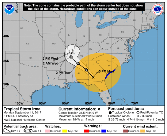
United States: Tropical Storm IRMA 11/2100Z Update from NHC and others – Updated 11 Sep 2017 2145z (GMT/UTC)

TROPICAL STORM IRMA

IRMA CONTINUES TO SLOWLY WEAKEN WHILE MOVING OVER SOUTHWESTERN GEORGIA – NHC

⚠️

A Storm Surge Warning is in effect for…
* North of Fernandina Beach to the South Santee River
* North of Clearwater Beach to the Aucilla River

A Tropical Storm Warning is in effect for…
* North of Altamaha Sound to the South Santee River

(Please check comments at bottom of page for updates)

National Hurricane Center (FL)

SPECIAL EMERGENCY MESSAGE FROM NWS

152552_5day_cone_with_line_and_wind TS IRMA Adv 51


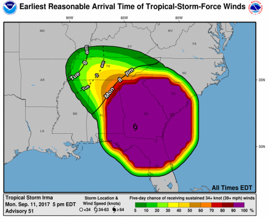
152552_earliest_reasonable_toa_34 51

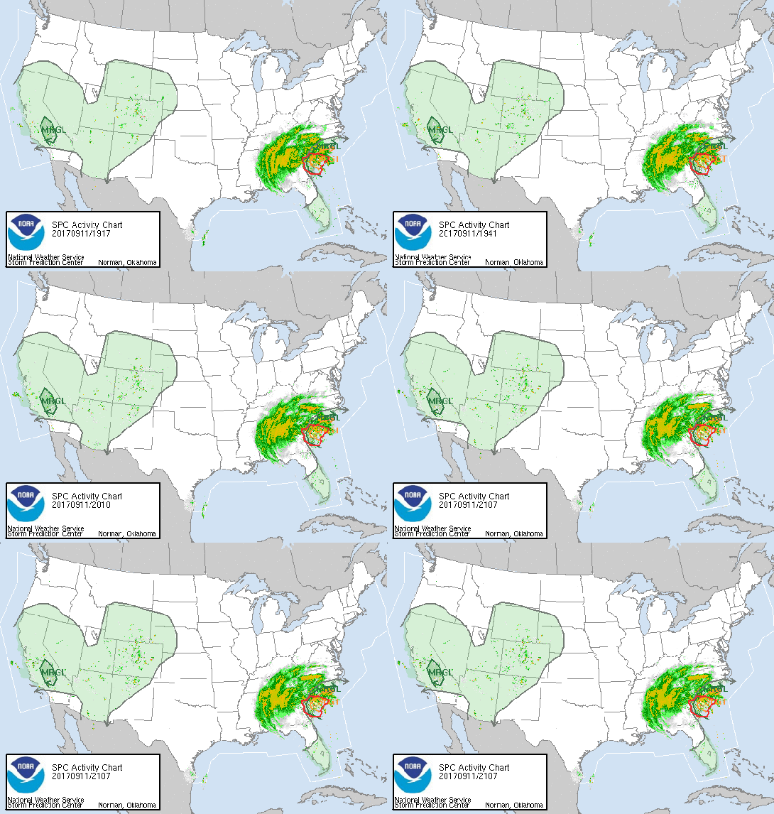
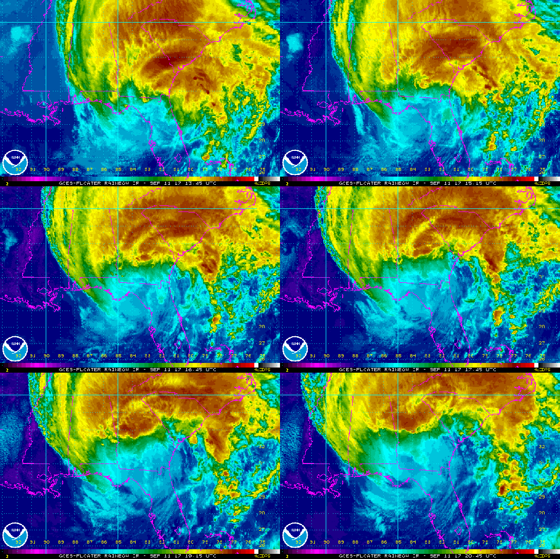
activity_looprb_lalo-animated2

southeast_loop

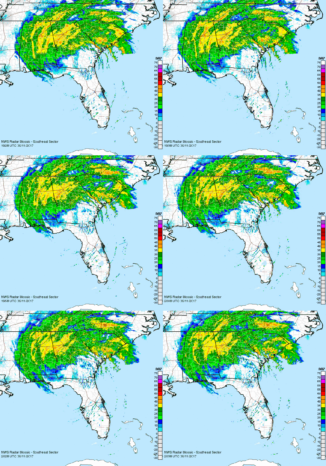
Robins Air Force Base, GA Radar

Wind Probs  

(Please check comments at bottom of page for updates)

ZCZC MIATCPAT1 ALL
TTAA00 KNHC DDHHMM

BULLETIN
Tropical Storm Irma Advisory Number 51
NWS National Hurricane Center Miami FL AL112017
500 PM EDT Mon Sep 11 2017

…IRMA CONTINUES TO SLOWLY WEAKEN WHILE MOVING OVER SOUTHWESTERN
GEORGIA…


SUMMARY OF 500 PM EDT…2100 UTC…INFORMATION
———————————————-
LOCATION…31.5N 84.0W
ABOUT 10 MI…15 KM E OF ALBANY GEORGIA
ABOUT 150 MI…240 KM S OF ATLANTA GEORGIA
MAXIMUM SUSTAINED WINDS…50 MPH…85 KM/H
PRESENT MOVEMENT…NNW OR 340 DEGREES AT 17 MPH…28 KM/H
MINIMUM CENTRAL PRESSURE…985 MB…29.09 INCHES


WATCHES AND WARNINGS
——————–
CHANGES WITH THIS ADVISORY:

The Storm Surge Warnings from Fernandina Beach southward, from
the Aucilla River westward, and from Clearwater Beach southward,
including Tampa Bay, have been discontinued.

The Tropical Storm Warning from the Flagler/Volusia County line to
Altamaha Sound is discontinued.

The Tropical Storm Warning from north of the Suwannee River to the
Okaloosa/Walton County line is discontinued.

SUMMARY OF WATCHES AND WARNINGS IN EFFECT:

A Storm Surge Warning is in effect for…
* North of Fernandina Beach to the South Santee River
* North of Clearwater Beach to the Aucilla River

A Tropical Storm Warning is in effect for…
* North of Altamaha Sound to the South Santee River

A Storm Surge Warning means there is a danger of life-threatening
inundation, from rising water moving inland from the coastline,
during the next 36 hours in the indicated locations. For a
depiction of areas at risk, please see the National Weather
Service Storm Surge Watch/Warning Graphic, available at
hurricanes.gov. This is a life-threatening situation. Persons
located within these areas should take all necessary actions to
protect life and property from rising water and the potential for
other dangerous conditions. Promptly follow evacuation and other
instructions from local officials.

Interests elsewhere in the southeastern United States should monitor
the progress of Irma.

For storm information specific to your area, including possible
inland watches and warnings, please monitor products issued by your
local National Weather Service forecast office.


DISCUSSION AND 48-HOUR OUTLOOK
——————————
At 500 PM EDT (2100 UTC), the center of Tropical Storm Irma was
located near latitude 31.5 North, longitude 84.0 West. Irma is
moving toward the north-northwest near 17 mph (28 km/h), and a
turn toward the northwest is expected by Tuesday morning. On the
forecast track, the center of Irma will continue to move over
southwestern Georgia tonight and move into Alabama on Tuesday.

Maximum sustained winds have decreased to near 50 mph (85 km/h) with
higher gusts. Continued weakening is forecast, and Irma is likely
to become a tropical depression on Tuesday.

Tropical-storm-force winds extend outward up to 415 miles (665 km)
from the center.

The estimated minimum central pressure is 985 mb (29.09 inches).


HAZARDS AFFECTING LAND
———————-
STORM SURGE: The combination of a dangerous storm surge and the
tide will cause normally dry areas near the coast to be flooded by
rising waters moving inland from the shoreline. The water is
expected to reach the following HEIGHTS ABOVE GROUND if the peak
surge occurs at the time of high tide…

North of Clearwater Beach to Aucilla River…4 t 6 ft
West of Aucilla River to Ochlockonee River…1 to 3 ft
Clearwater Beach to Bonita Beach including Tampa Bay…1 to 3 ft

South Santee River to North of Fernandina Beach…4 to 6 ft
Fernandina Beach to Flagler/Volusia County line, including the St.
Johns River…1 to 3 ft

The deepest water will occur along the immediate coast in areas of
onshore winds, where the surge will be accompanied by large and
destructive waves. Surge-related flooding depends on the relative
timing of the surge and the tidal cycle, and can vary greatly over
short distances. For information specific to your area, please see
products issued by your local National Weather Service forecast
office.

WIND: Tropical storm conditions are expected in portions of the
warning area into tonight.

Rainfall: Irma is expected to produce the following rain
accumulations through Wednesday:

South Carolina and north-central Georgia and Alabama into the
southern Appalachians…3 to 6 inches with isolated 10 inches.
Northern Mississippi and southern portions of Tennessee and North
Carolina…2 to 4 inches.

TORNADOES: Isolated tornadoes are possible tonight along the South
Carolina coast.

SURF: Swells generated by Irma are affecting the southeast coast of
the United States. These swells are likely to cause life-
threatening surf and rip current conditions. Please consult
products from your local weather office.


NEXT ADVISORY
————-
Next intermediate advisory at 800 PM EDT.
Next complete advisory at 1100 PM EDT.

$$
Forecaster Pasch

NNNN

LOCAL STATEMENTS

Issuing WFO Homepage Local Impacts Local Statement
Miami, FL Threats and Impacts 1125 AM EDT Mon Sep 11
Charleston, SC Not currently available 1139 AM EDT Mon Sep 11
Tallahassee, FL Threats and Impacts 1141 AM EDT Mon Sep 11 2017 /1041 AM CDT Mon Sep 11
Atlanta, GA Threats and Impacts 1147 AM EDT Mon Sep 11
Birmingham, AL Threats and Impacts 1124 AM CDT Mon Sep 11
Melbourne, FL Threats and Impacts 233 PM EDT Mon Sep 11
Tampa Bay Area, FL Threats and Impacts 456 PM EDT Mon Sep 11
Jacksonville, FL Threats and Impacts 515 PM EDT Mon Sep 11

============================================================================

TROPICAL STORM RISK (TSR)

N Atlantic: Storm Alert issued at 11 Sep, 2017 21:00 GMT

Tropical Storm IRMA is currently located near 31.5 N 84.0 W with maximum 1-min sustained winds of 45kts (52 mph). IRMA is forecast to affect land to the following likelihood(s) at the given lead time(s):

Yellow Alert Country(s) or Province(s)
    the United States
        probability for TS is 100% currently
Yellow Alert City(s) and Town(s)
    Charlotte (35.2 N, 80.8 W)
        probability for TS is 100% currently
    Columbia (34.0 N, 81.0 W)
        probability for TS is 100% currently
    Atlanta (33.8 N, 84.4 W)
        probability for TS is 100% currently
    Myrtle Beach (33.7 N, 79.1 W)
        probability for TS is 100% currently
    Charleston (32.9 N, 80.0 W)
        probability for TS is 100% currently
    Montgomery (32.4 N, 86.3 W)
        probability for TS is 100% currently
    Savannah (32.0 N, 81.0 W)
        probability for TS is 100% currently
    Tallahassee (30.4 N, 84.3 W)
        probability for TS is 100% currently
    Jacksonville (30.3 N, 81.7 W)
        probability for TS is 100% currently
    Orlando (29.0 N, 81.5 W)
        probability for TS is 90% currently
    Tampa (28.0 N, 82.5 W)
        probability for TS is 70% currently
    Nashville (36.1 N, 86.8 W)
        probability for TS is 60% in about 21 hours

Green Alert City(s) and Town(s)
    Pensacola (30.7 N, 87.0 W)
        probability for TS is 40% within 9 hours
    Louisville (38.4 N, 86.0 W)
        probability for TS is 35% in about 21 hours

Note that
Yellow Alert (Elevated) is CAT 1 or above to between 10% and 30% probability, or TS to above 50% probability.
Green Alert (Low) is TS to between 31% and 50% probability.
CAT 1 means Hurricane strength winds of at least 74 mph, 119 km/h or 64 knots 1-min sustained.
TS means Tropical Storm strength winds of at least 39 mph, 63 km/h or 34 knots 1-min sustained.

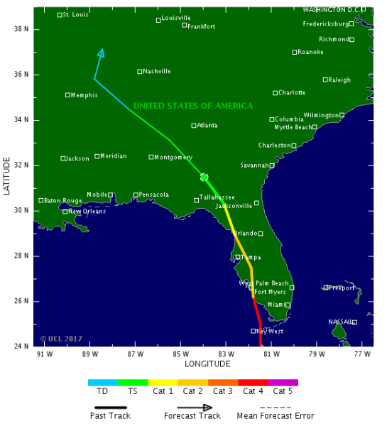
For graphical forecast information and further details please visit http://www.tropicalstormrisk.com/


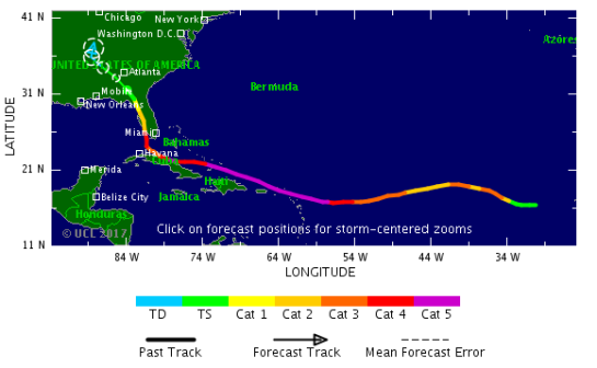
201711N tsr1 irma 11

201711N_0 tsr2 irma 11

=============================================================================

Other


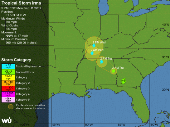
at201711_5day ts irma

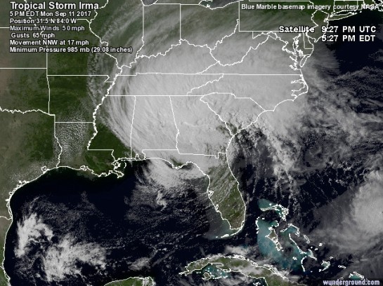
at201711_sat ts irma


The two images above are from @wunderground

Ferocious Irma Pounding Florida, But It Could Have Been Worse

No Rest for the Hurricane-Weary: Jose a Potential East Coast Threat

windy.com – interactive animated wind map

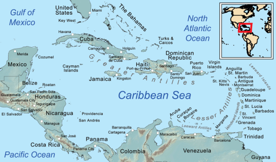
Caribbean_general_map

Caribbean General Map (Image: Kmusser)

=============================================================================

MARITIME/SHIPPING

METAREA4 / HURRICANE_ADVISORY / 112035

WTNT21 KNHC 112035
TCMAT1

TROPICAL STORM IRMA FORECAST/ADVISORY NUMBER 51
NWS NATIONAL HURRICANE CENTER MIAMI FL AL112017
2100 UTC MON SEP 11 2017

CHANGES IN WATCHES AND WARNINGS WITH THIS ADVISORY…

THE STORM SURGE WARNINGS FROM FERNANDINA BEACH SOUTHWARD… FROM
THE AUCILLA RIVER WESTWARD… AND FROM CLEARWATER BEACH
SOUTHWARD… INCLUDING TAMPA BAY… HAVE BEEN DISCONTINUED.

THE TROPICAL STORM WARNING FROM THE FLAGLER/VOLUSIA COUNTY LINE TO
ALTAMAHA SOUND IS DISCONTINUED.

THE TROPICAL STORM WARNING FROM NORTH OF THE SUWANNEE RIVER TO THE
OKALOOSA/WALTON COUNTY LINE IS DISCONTINUED.

SUMMARY OF WATCHES AND WARNINGS IN EFFECT…

A STORM SURGE WARNING IS IN EFFECT FOR…
* NORTH OF FERNANDINA BEACH TO THE SOUTH SANTEE RIVER
* NORTH OF CLEARWATER BEACH TO THE AUCILLA RIVER

A TROPICAL STORM WARNING IS IN EFFECT FOR…
* NORTH OF ALTAMAHA SOUND TO THE SOUTH SANTEE RIVER

A STORM SURGE WARNING MEANS THERE IS A DANGER OF LIFE-THREATENING
INUNDATION… FROM RISING WATER MOVING INLAND FROM THE COASTLINE…
DURING THE NEXT 36 HOURS IN THE INDICATED LOCATIONS. FOR A
DEPICTION OF AREAS AT RISK… PLEASE SEE THE NATIONAL WEATHER
SERVICE STORM SURGE WATCH/WARNING GRAPHIC… AVAILABLE AT
HURRICANES.GOV. THIS IS A LIFE-THREATENING SITUATION. PERSONS
LOCATED WITHIN THESE AREAS SHOULD TAKE ALL NECESSARY ACTIONS TO
PROTECT LIFE AND PROPERTY FROM RISING WATER AND THE POTENTIAL FOR
OTHER DANGEROUS CONDITIONS. PROMPTLY FOLLOW EVACUATION AND OTHER
INSTRUCTIONS FROM LOCAL OFFICIALS.

INTERESTS ELSEWHERE IN THE SOUTHEASTERN UNITED STATES SHOULD MONITOR
THE PROGRESS OF IRMA.

TROPICAL STORM CENTER LOCATED NEAR 31.5N 84.0W AT 11/2100Z
POSITION ACCURATE WITHIN 20 NM

PRESENT MOVEMENT TOWARD THE NORTH-NORTHWEST OR 340 DEGREES AT 15 KT

ESTIMATED MINIMUM CENTRAL PRESSURE 985 MB
MAX SUSTAINED WINDS 45 KT WITH GUSTS TO 55 KT.
34 KT…….360NE 230SE 150SW 240NW.
12 FT SEAS..600NE 390SE 390SW 0NW.
WINDS AND SEAS VARY GREATLY IN EACH QUADRANT. RADII IN NAUTICAL
MILES ARE THE LARGEST RADII EXPECTED ANYWHERE IN THAT QUADRANT.

REPEAT…CENTER LOCATED NEAR 31.5N 84.0W AT 11/2100Z
AT 11/1800Z CENTER WAS LOCATED NEAR 30.9N 83.5W

FORECAST VALID 12/0600Z 33.1N 85.5W…INLAND
MAX WIND 35 KT…GUSTS 45 KT.
34 KT…220NE 120SE 100SW 100NW.

FORECAST VALID 12/1800Z 34.5N 87.3W…INLAND
MAX WIND 30 KT…GUSTS 40 KT.

FORECAST VALID 13/0600Z 35.8N 88.8W…POST-TROP/INLAND
MAX WIND 25 KT…GUSTS 35 KT.

FORECAST VALID 13/1800Z 37.0N 88.5W…POST-TROP/INLAND
MAX WIND 20 KT…GUSTS 30 KT.

FORECAST VALID 14/1800Z…DISSIPATED

REQUEST FOR 3 HOURLY SHIP REPORTS WITHIN 300 MILES OF 31.5N 84.0W

NEXT ADVISORY AT 12/0300Z

$$
FORECASTER PASCH

=============================================================================

000
FZNT25 KNHC 112138
OFFN04

NAVTEX Marine Forecast
NWS National Hurricane Center Miami, FL
538 PM EDT Mon Sep 11 2017

…Please refer to Coastal Waters Forecasts (CWF) available
through NOAA Weather Radio and other means for detailed
Coastal Waters Forecasts…

Southeast Gulf of Mexico

.SYNOPSIS…Tropical Storm Irma near 31.5N 84.0W, 985 mb moving
NNW at 15 kt at 5 PM EDT, and inland over SW Georgia. Maximum
sustained winds 45 kt gusts 55 kt. Irma will continue moving NNW
and and weaken to a depression as it move farther N. A weak
pressure pattern will set up across the Gulf in the wake of Irma
through the remainder of the week. N to NE swell from Irma will
dominate seas across the Gulf through Tue.

.TONIGHT…W to NW winds 20 to 25 kt, diminishing to 10 to 15 kt
late in the night. Seas 7 to 10 ft in NW to N swell. Slight
chance of showers.
.TUE…SW to W winds 10 to 15 kt. Seas 5 to 7 ft,subsiding to
3 to 5 ft late in the afternoon.
.TUE NIGHT…S to SW winds 5 to 10 kt. Seas 3 to 5 ft.
.WED…S to SW winds 5 to 10 kt. Seas 3 ft early in the morning,
subsiding to 2 ft or less. Isolated thunderstorms.
.WED NIGHT…SE to S winds 5 to 10 kt. Seas 2 ft or less.
.THU…S to SW winds 5 to 10 kt. Seas 2 ft or less.
.THU NIGHT…S winds 5 to 10 kt, shifting to E after midnight.
Seas 2 ft or less.
.FRI…E winds 5 to 10 kt. Seas 2 ft or less.
.FRI NIGHT…NE winds 5 to 10 kt. Seas 2 ft or less.
.SAT…NE winds 5 to 10 kt. Seas 2 ft or less.
.SAT NIGHT…N to NE winds 10 to 15 kt. Seas 2 ft or less.

Within 200 nm east of the coast of Florida

.SYNOPSIS…Tropical Storm Irma near 31.5N 84.0W, 985 mb moving
NNW at 15 kt at 5 PM EDT, and inland over SW Georgia. Farther E,
Hurricane Jose is near 26.4N 69.2W, 973 mb moving N at 10 kt.
Maximum sustained winds 85 kt gusts to 105 kt. Jose is expected
to move to 27.2N 69.0W tonight, to 27.0N 67.7W Tue afternoon, to
26.3N 66.7W Tue night, to 25.3N 66.1W Wed afternoon, to 24.4N
68.6W Thu afternoon, before moving slowly NW thereafter as its
completes this clockwise loop. Swell from Jose will dominate
area waters Tue through Fri.

…TROPICAL STORM WARNING…

.TONIGHT…SW to W winds 15 to 20 kt S of 27N, and SW 20 to 25 kt
N of 27N. Seas 7 to 10 ft in NE to E swell. Scattered showers and
isolated thunderstorms.
.TUE…W winds 5 to 10 kt S of 27N, and SW to W 15 to 20 kt N of
27N. Seas 6 to 8 ft in NE to E swell. Scattered showers and
isolated thunderstorms.
.TUE NIGHT…SW winds less than 5 kt S of 27N, and SW to W 10 to
15 kt N of 27N. Seas 4 to 6 ft. Scattered showers and isolated
thunderstorms.
.WED…S of 27N,SW to W winds less than 5 kt, shifting to N late
in the afternoon. N of 27N,SW winds 5 to 10 kt, shifting to E to
SE in the afternoon. Seas 3 to 5 ft. Slight chance of showers and
isolated thunderstorms.
.WED NIGHT…E to SE winds 5 to 10 kt. Seas 3 to 5 ft.
.THU…NE to E winds less than 5 kt. Seas 3 to 4 ft in NE swell.
.THU NIGHT…NE to E winds 5 to 10 kt. Seas 3 to 5 ft.
.FRI…NE winds 10 to 15 kt. Seas 4 to 6 ft.
.FRI NIGHT…N to NE winds 15 to 20 kt. Seas 6 to 9 ft.
.SAT…N winds 20 to 25 kt. Seas 8 to 11 ft in NE swell.
.SAT NIGHT…NW winds 20 to 25 kt. Seas 8 to 11 ft in NE swell.

=============================================================================

Do not use any information on this site for life or death decisions. All information is intended as supplementary to official sources. Kindly refer to your country’s official weather agency/government website for local warnings, advisories and bulletins.

US(TX/LA/MS/TN): Tropical Depression Harvey 31/0300Z update (NHC FL) – Updated 31 Aug 2017 0920z (GMT/UTC)

Tropical Depression Harvey

…FLOODING RAINS CONTINUE OVER EXTREME EASTERN TEXAS AND WESTERN
LOUISIANA…
…HEAVY RAINS EXPECTED TO SPREAD NORTHEASTWARD OVER THE MISSISSIPPI
AND TENNESSEE VALLEYS DURING THE NEXT DAY OR TWO…

Catastrophic and life-threatening flooding continues in southeastern
Texas and portions of southwestern Louisiana.

…..catastrophic and life-threatening flooding
will continue in and around Houston, Beaumont/Port Arthur,
and eastward into southwest Louisiana for the rest of the week


at201709_5day TD HARVEY WUND

(Image: @wunderground)

at201709_sat TD HARVEY WUND

(Image: @wunderground)

National Hurricane Center (FL)

030124_5day_cone_with_line_and_wind TD HARVEY

avn_lalo-animated TD HARVEY

030124WPCQPF_sm rain 31

ZCZC MIATCPAT4 ALL
TTAA00 KNHC DDHHMM

BULLETIN
Tropical Depression Harvey Advisory Number 43
NWS National Hurricane Center Miami FL AL092017
1000 PM CDT Wed Aug 30 2017

…FLOODING RAINS CONTINUE OVER EXTREME EASTERN TEXAS AND WESTERN
LOUISIANA…
…HEAVY RAINS EXPECTED TO SPREAD NORTHEASTWARD OVER THE MISSISSIPPI
AND TENNESSEE VALLEYS DURING THE NEXT DAY OR TWO…

SUMMARY OF 1000 PM CDT…0300 UTC…INFORMATION
———————————————–
LOCATION…31.7N 92.3W
ABOUT 30 MI…50 KM NNE OF ALEXANDRIA LOUISIANA
ABOUT 100 MI…160 KM SE OF SHREVEPORT LOUISIANA
MAXIMUM SUSTAINED WINDS…35 MPH…55 KM/H
PRESENT MOVEMENT…NNE OR 30 DEGREES AT 9 MPH…15 KM/H
MINIMUM CENTRAL PRESSURE…998 MB…29.47 INCHES


WATCHES AND WARNINGS
——————–
CHANGES WITH THIS ADVISORY:

None

SUMMARY OF WATCHES AND WARNINGS IN EFFECT:

There are no coastal watches or warnings in effect.

Catastrophic and life-threatening flooding continues in southeastern
Texas and portions of southwestern Louisiana. Please see warnings
and other products issued by your local National Weather Service
office for additional information on this life-threatening
situation.


DISCUSSION AND 48-HOUR OUTLOOK
——————————
At 1000 PM CDT (0300 UTC), the center of Tropical Depression Harvey
was located near latitude 31.7 North, longitude 92.3 West. The
depression is moving toward the north-northeast near 9 mph (15 km/h)
and this motion is expected to continue tonight. A turn toward the
northeast is expected Thursday or Thursday night. On the forecast
track, the center of Harvey should move through central Louisiana
tonight, then move through northeastern Louisiana and northwestern
Mississippi Thursday and Thursday night, and over the Tennessee
Valley region on Friday.

Maximum sustained winds are near 35 mph (55 km/h) with higher gusts.
Gradual weakening is expected over the next 48 hours.

The estimated minimum central pressure is 998 mb (29.47 inches).


HAZARDS AFFECTING LAND
———————-
RAINFALL: Harvey is expected to produce additional rainfall
accumulations of 4 to 8 inches from southwestern Louisiana and the
adjacent border of eastern Texas northeastward into western
Tennessee and Kentucky through Friday with isolated amounts up to 12
inches. The threat of heavy rains has ended in the Houston/
Galveston area. However catastrophic and life-threatening flooding
will continue in and around Houston, Beaumont/Port Arthur,
and eastward into southwest Louisiana for the rest of the week. The
expected heavy rains spreading northeastward from Louisiana into
western Kentucky may also lead to flash flooding and increased river
and small stream flooding. DO NOT ATTEMPT TO TRAVEL IN THE AFFECTED
AREA IF YOU ARE IN A SAFE PLACE. DO NOT DRIVE INTO FLOODED
ROADWAYS. Please see warnings and products issued by your local
National Weather Service office for additional information on this
life-threatening situation.

Elsewhere, the outer bands of Harvey are expected to produce
additional rainfall amounts of 3 to 6 inches over portions of the
central and eastern Gulf States and 2 to 4 inches farther north into
parts of the Tennessee Valley, Ohio Valley and southern Mid Atlantic
through Saturday. These rains may lead to flooding concerns across
these areas.

A list of preliminary rainfall observations compiled by the NOAA
Weather Prediction Center can be found at:
http://www.wpc.ncep.noaa.gov/discussions/nfdscc1.html

STORM SURGE: Water levels along the northwestern and northern
Gulf coast should subside very slowly over the next day or two.

TORNADOES: Isolated tornadoes are possible tonight across parts of
Mississippi, southern Alabama, and southwest Georgia. Additional
tornadoes are possible on Thursday afternoon and evening across
northern portions of Mississippi, Alabama, Georgia, and into parts
of Tennessee.


NEXT ADVISORY
————-
This is the last public advisory issued by the National Hurricane
Center on Harvey. Future information on this system can be found in
Public Advisories issued by the Weather Prediction Center beginning
at 4 AM CDT, under AWIPS header TCPAT4, WMO header WTNT34 KWNH, and
on the web at http://www.wpc.ncep.noaa.gov. These advisories will
also continue to be found on the National Hurricane Center website
at hurricanes.gov.

$$
Forecaster Brown

NNNN

=============================================================================

MARITIME/SHIPPING

graphicast_at_latest_sm3 31METAREA4 / HURRICANE_ADVISORY / 300850

WTNT24 KNHC 310254
TCMAT4

TROPICAL DEPRESSION HARVEY FORECAST/ADVISORY NUMBER 43
NWS NATIONAL HURRICANE CENTER MIAMI FL AL092017
0300 UTC THU AUG 31 2017

CHANGES IN WATCHES AND WARNINGS WITH THIS ADVISORY…

NONE

SUMMARY OF WATCHES AND WARNINGS IN EFFECT…

THERE ARE NO COASTAL WATCHES OR WARNINGS IN EFFECT.

CATASTROPHIC AND LIFE-THREATENING FLOODING CONTINUES IN SOUTHEASTERN
TEXAS AND PORTIONS OF SOUTHWESTERN LOUISIANA. PLEASE SEE WARNINGS
AND OTHER PRODUCTS ISSUED BY YOUR LOCAL NATIONAL WEATHER SERVICE
OFFICE FOR ADDITIONAL INFORMATION ON THIS LIFE-THREATENING
SITUATION.

TROPICAL DEPRESSION CENTER LOCATED NEAR 31.7N 92.3W AT 31/0300Z
POSITION ACCURATE WITHIN 25 NM

PRESENT MOVEMENT TOWARD THE NORTH-NORTHEAST OR 30 DEGREES AT 8 KT

ESTIMATED MINIMUM CENTRAL PRESSURE 998 MB
MAX SUSTAINED WINDS 30 KT WITH GUSTS TO 40 KT.
WINDS AND SEAS VARY GREATLY IN EACH QUADRANT. RADII IN NAUTICAL
MILES ARE THE LARGEST RADII EXPECTED ANYWHERE IN THAT QUADRANT.

REPEAT…CENTER LOCATED NEAR 31.7N 92.3W AT 31/0300Z
AT 31/0000Z CENTER WAS LOCATED NEAR 31.3N 92.6W

FORECAST VALID 31/1200Z 32.8N 91.4W…INLAND
MAX WIND 25 KT…GUSTS 35 KT.

FORECAST VALID 01/0000Z 34.5N 89.7W…INLAND
MAX WIND 25 KT…GUSTS 35 KT.

FORECAST VALID 01/1200Z 35.9N 87.6W…INLAND
MAX WIND 25 KT…GUSTS 35 KT.

FORECAST VALID 02/0000Z 37.0N 85.7W…INLAND
MAX WIND 20 KT…GUSTS 30 KT.

FORECAST VALID 03/0000Z…DISSIPATED

REQUEST FOR 3 HOURLY SHIP REPORTS WITHIN 300 MILES OF 31.7N 92.3W

THIS IS THE LAST FORECAST/ADVISORY ISSUED BY THE NATIONAL HURRICANE
CENTER ON THIS SYSTEM. FUTURE INFORMATION ON THIS SYSTEM CAN BE
FOUND IN PUBLIC ADVISORIES ISSUED BY THE WEATHER PREDICTION CENTER
BEGINNING AT 0900 UTC, UNDER AWIPS HEADER TCPAT4, WMO HEADER
WTNT34 KWNH, AND ON THE WEB AT HTTP://WWW.WPC.NCEP.NOAA.GOV.

$$
FORECASTER BROWN


=============================================================================

000
FZNT24 KNHC 310857
OFFNT4

Offshore Waters Forecast for the Gulf of Mexico
NWS National Hurricane Center Miami, FL
457 AM EDT Thu Aug 31 2017

Offshore Waters Forecast for the Gulf of Mexico

Seas given as significant wave height, which is the average
height of the highest 1/3 of the waves. Individual waves may be
more than twice the significant wave height.

GMZ001-312100-
Synopsis for the Gulf of Mexico
457 AM EDT Thu Aug 31 2017

.SYNOPSIS…Tropical Depression Harvey is inland over Louisiana.
As Harvey moves farther inland, a ridge will slowly build back
across the Gulf through the remainder of the week before a trough
develops over the western Gulf this weekend. An area of low pressure
could form along this trough over the southwestern Gulf by the
weekend.

$$

GMZ011-312100-
NW Gulf including Stetson Bank-
457 AM EDT Thu Aug 31 2017

.TODAY…W winds 5 to 10 kt. Seas 2 ft or less.
.TONIGHT…W to NW winds 5 to 10 kt, shifting to SE to S. Seas
2 ft or less.
.FRI…S winds less than 5 kt, shifting to NE to E. Seas 2 ft or
less.
.FRI NIGHT…E winds 5 to 10 kt. Seas 2 ft or less.
.SAT…E winds 5 to 10 kt. Seas 2 ft or less.
.SAT NIGHT…E winds 10 kt. Seas 2 ft or less.
.SUN…E winds 10 kt. Seas 2 ft or less, building to 3 ft in the
afternoon.
.SUN NIGHT…E winds 10 to 15 kt. Seas 3 ft.
.MON…E to SE winds 10 to 15 kt. Seas 3 to 4 ft.
.MON NIGHT…SE winds 10 to 15 kt. Seas 4 to 6 ft.

$$

GMZ013-312100-
N Central Gulf including Flower Garden Banks Marine Sanctuary-
457 AM EDT Thu Aug 31 2017

.TODAY…SW winds 15 to 20 kt. Seas 4 to 6 ft.
.TONIGHT…SW to W winds 10 to 15 kt. Seas 3 to 5 ft.
.FRI…SW winds 5 to 10 kt. Seas 3 ft, subsiding to 2 ft or
less.
.FRI NIGHT…SW winds 5 to 10 kt, shifting to NE to E late. Seas
2 ft or less.
.SAT…E to SE winds 5 to 10 kt. Seas 2 ft or less.
.SAT NIGHT…SE winds 5 to 10 kt. Seas 2 ft or less.
.SUN…E to SE winds 5 to 10 kt. Seas 2 ft or less.
.SUN NIGHT…SE winds 5 to 10 kt. Seas 2 ft or less.
.MON…E to SE winds 10 to 15 kt. Seas 2 ft or less, building to
3 ft in the afternoon.
.MON NIGHT…E to SE winds 10 to 15 kt. Seas 3 to 4 ft.

$$

GMZ015-312100-
NE Gulf N of 25N E of 87W-
457 AM EDT Thu Aug 31 2017

.TODAY…SE to S winds 10 to 15 kt. Seas 4 to 6 ft.
.TONIGHT…SE winds 5 to 10 kt S of 27N, and S to SW 10 to 15 kt
elsewhere. Seas 3 to 5 ft.
.FRI…S to SW winds 5 to 10 kt. Seas 3 to 4 ft.
.FRI NIGHT…W winds 5 to 10 kt, shifting to SE to S late. Seas 3 ft, subsiding to 2 ft or less.
.SAT…SE winds less than 5 kt. Seas 2 ft or less.
.SAT NIGHT…NE winds less than 5 kt. Seas 2 ft or less.
.SUN…NE to E winds 5 to 10 kt. Seas 2 ft or less.
.SUN NIGHT…NE to E winds 5 to 10 kt. Seas 2 ft or less.
.MON…NE to E winds 5 to 10 kt. Seas 2 ft or less.
.MON NIGHT…NE to E winds 10 to 15 kt. Seas 2 ft or less.

$$

GMZ017-312100-
W Central Gulf from 22N to 26N W of 94W-
457 AM EDT Thu Aug 31 2017

.TODAY…SE winds 5 to 10 kt. Seas 2 ft or less.
.TONIGHT…E winds 5 to 10 kt. Seas 2 ft or less.
.FRI…E winds 5 to 10 kt. Seas 2 ft or less. Scattered showers
and isolated thunderstorms.
.FRI NIGHT…E to SE winds 5 to 10 kt. Seas 2 ft or less.
.SAT…E winds 5 to 10 kt. Seas 2 ft or less.
.SAT NIGHT…NE to E winds 5 to 10 kt. Seas 3 ft.
.SUN…NE to E winds 5 to 10 kt. Seas 3 ft.
.SUN NIGHT…E winds 10 to 15 kt. Seas 3 to 5 ft.
.MON…E to SE winds 15 to 20 kt. Seas 4 to 6 ft.
.MON NIGHT…E to SE winds 15 to 20 kt. Seas 4 to 6 ft.

$$

GMZ019-312100-
Central Gulf from 22N to 26N between 87W and 94W-
457 AM EDT Thu Aug 31 2017

.TODAY…SE to S winds 5 to 10 kt. Seas 3 to 4 ft.
.TONIGHT…E winds 10 to 15 kt S of 24N, and E to SE 5 to 10 kt
elsewhere. Seas 3 ft, subsiding to 2 ft or less.
.FRI…SE winds 10 to 15 kt. Seas 2 ft or less, building to
3 ft. Scattered showers and isolated thunderstorms.
.FRI NIGHT…E winds 15 to 20 kt S of 24N, and E 5 to 10 kt
elsewhere. Seas 3 to 4 ft.
.SAT…E to SE winds 10 to 15 kt. Seas 3 to 4 ft.
.SAT NIGHT…E to SE winds 10 to 15 kt. Seas 3 to 4 ft.
.SUN…E to SE winds 10 to 15 kt. Seas 3 to 4 ft.
.SUN NIGHT…E to SE winds 15 to 20 kt. Seas 3 to 5 ft.
.MON…E to SE winds 15 to 20 kt. Seas 4 to 6 ft.
.MON NIGHT…E winds 15 to 20 kt. Seas 4 to 6 ft.

$$

GMZ021-312100-
E Gulf from 22N to 25N E of 87W including Straits of Florida-
457 AM EDT Thu Aug 31 2017

.TODAY…E to SE winds 5 to 10 kt. Seas 3 ft. Scattered showers
and isolated thunderstorms.
.TONIGHT…E to SE winds 5 to 10 kt. Seas 3 ft.
.FRI…SE winds 5 to 10 kt. Seas 3 ft.
.FRI NIGHT…SE winds 5 to 10 kt, shifting to E. Seas 3 ft,
subsiding to 2 ft or less.
.SAT…E to SE winds 5 to 10 kt. Seas 2 ft or less.
.SAT NIGHT…NE to E winds 5 to 10 kt. Seas 2 ft or less.
.SUN…NE to E winds 10 to 15 kt. Seas 2 ft or less.
.SUN NIGHT…NE to E winds 10 to 15 kt. Seas 3 ft.
.MON…E winds 10 to 15 kt. Seas 3 to 4 ft.
.MON NIGHT…NE to E winds 10 to 15 kt. Seas 3 ft.

$$

GMZ023-312100-
SW Gulf S of 22N W of 94W-
457 AM EDT Thu Aug 31 2017

.TODAY…NE to E winds 5 to 10 kt. Seas 3 ft, subsiding to 2 ft
or less.
.TONIGHT…E winds 5 to 10 kt. Seas 2 ft or less.
.FRI…NE winds 5 to 10 kt. Seas 2 ft or less. Scattered showers
and isolated thunderstorms.
.FRI NIGHT…N winds 5 to 10 kt S of 21N W of 95W, and NE to E
10 to 15 kt elsewhere. Seas 2 ft or less. Scattered showers and
isolated thunderstorms.
.SAT…NE winds 10 to 15 kt, shifting to NW 5 to 10 kt in the
afternoon. Seas 2 ft or less.
.SAT NIGHT…N to NE winds 5 to 10 kt. Seas 3 ft.
.SUN…E to SE winds 10 to 15 kt, shifting to W to NW in the
afternoon. Seas 3 to 4 ft.
.SUN NIGHT…N winds 10 to 15 kt. Seas 3 to 4 ft.
.MON…SW to W winds 10 to 15 kt. Seas 3 to 5 ft.
.MON NIGHT…N to NE winds 10 to 15 kt, shifting to E to SE
late. Seas 3 to 5 ft.

$$

GMZ025-312100-
E Bay of Campeche including Campeche Bank-
457 AM EDT Thu Aug 31 2017

.TODAY…E to SE winds 5 to 10 kt. Seas 3 ft.
.TONIGHT…E winds 10 to 15 kt. Seas 3 ft.
.FRI…E to SE winds 10 to 15 kt. Seas 3 ft in the morning,
subsiding to 2 ft or less. Scattered showers and isolated thunderstorms.
.FRI NIGHT…NE to E winds 15 to 20 kt. Seas 2 ft or less,
building to 3 to 4 ft late. Scattered showers and
isolated thunderstorms.
.SAT…SE winds 10 to 15 kt. Seas 3 to 4 ft.
.SAT NIGHT…E winds 10 to 15 kt. Seas 3 ft in the evening,
subsiding to 2 ft or less.
.SUN…SE winds 10 to 15 kt. Seas 3 ft.
.SUN NIGHT…E winds 15 to 20 kt. Seas 3 to 4 ft.
.MON…E to SE winds 15 to 20 kt. Seas 3 to 5 ft.
.MON NIGHT…NE to E winds 10 to 15 kt. Seas 3 to 4 ft.

$$

Forecaster GR

=============================================================================

Do not use any information on this site for life or death decisions. All information is intended as supplementary to official sources. Kindly refer to your country’s official weather agency/government website for local warnings, advisories and bulletins.

United States (FL): Tropical Storm EMILY 311800Z nr 27.6N 82.2W, moving E at 10 mph (NHC FL) – Published 31 Jul 2017 1825z (GMT/UTC)

Tropical Storm EMILY

A Tropical Storm Warning is in effect for…
* Englewood to Bonita Beach Florida

National Hurricane Center (FL)


000
WTNT31 KNHC 311748
TCPAT1

BULLETIN
Tropical Storm Emily Intermediate Advisory Number 3A
NWS National Hurricane Center Miami FL AL062017
200 PM EDT Mon Jul 31 2017

…EMILY LOCATED INLAND OVER WEST-CENTRAL FLORIDA…
…HEAVY RAINFALL EXPECTED OVER THE CENTRAL AND SOUTHERN FLORIDA
PENINSULA…


SUMMARY OF 200 PM EDT…1800 UTC…INFORMATION
———————————————-
LOCATION…27.6N 82.2W
ABOUT 30 MI…50 KM SE OF TAMPA FLORIDA
ABOUT 35 MI…55 KM SW OF BARTOW FLORIDA
MAXIMUM SUSTAINED WINDS…40 MPH…65 KM/H
PRESENT MOVEMENT…E OR 85 DEGREES AT 10 MPH…17 KM/H
MINIMUM CENTRAL PRESSURE…1006 MB…29.71 INCHES


WATCHES AND WARNINGS
——————–
CHANGES WITH THIS ADVISORY:

The Tropical Storm Warning has been discontinued from Anclote River
southward to Englewood.

SUMMARY OF WATCHES AND WARNINGS IN EFFECT:

A Tropical Storm Warning is in effect for…
* Englewood to Bonita Beach Florida

A Tropical Storm Warning means that tropical storm conditions are
likely within the warning area, in this case within the next few
hours.

For storm information specific to your area, including possible
inland watches and warnings, please monitor products issued by your
local National Weather Service forecast office.


DISCUSSION AND 48-HOUR OUTLOOK
——————————
At 200 PM EDT (1800 UTC), the center of Tropical Storm Emily was
located near latitude 27.6 North, longitude 82.2 West. Emily is
moving toward the east near 10 mph (17 km/h), and this general
motion is expected to continue this afternoon. A turn toward the
northeast with an increase in forward speed are expected by tonight
and Tuesday. On the forecast track, the center of Emily will
continue to move farther inland over the west-central Florida
peninsula this afternoon, and move across central Florida through
tonight. Emily is forecast to move offshore of the east-central
Florida coast Tuesday morning.

Maximum sustained winds have decreased to near 45 mph (75 km/h) with
higher gusts. Emily is expected to weaken to a tropical depression
while it moves across the Florida peninsula this afternoon and
tonight.

Tropical-storm-force winds extend outward up to 60 miles (95 km),
mainly southeast through south of the center. A wind gust to 38 mph
was recently observed in Punta Gorda, Florida.

The estimated minimum central pressure based on nearby surface
observations is 1006 mb (29.71 inches).


HAZARDS AFFECTING LAND
———————-
RAINFALL: Emily is expected to produce total rain accumulations of
2 to 4 inches through Monday night along the west coast of central
Florida between the Tampa Bay area and Naples, with isolated amounts
up to 8 inches possible. Elsewhere across central and south Florida,
1 to 2 inches of rain is expected with localized amounts of up to 4
inches possible.

WIND: Tropical storm conditions are likely within the warning area
through this afternoon.

TORNADOES: A brief tornado could occur across the central and
southern Florida Peninsula today, with isolated waterspouts
possible over the coastal waters of southwestern Florida.


NEXT ADVISORY
————-
Next complete advisory at 500 PM EDT.

$$
Forecaster Stewart

MARITIME/SHIPPING

METAREA4 / HURRICANE_ADVISORY / 1434

WTNT21 KNHC 311434
TCMAT1

TROPICAL STORM EMILY FORECAST/ADVISORY NUMBER 3
NWS NATIONAL HURRICANE CENTER MIAMI FL AL062017
1500 UTC MON JUL 31 2017

CHANGES IN WATCHES AND WARNINGS WITH THIS ADVISORY…

NONE.

SUMMARY OF WATCHES AND WARNINGS IN EFFECT…

A TROPICAL STORM WARNING IS IN EFFECT FOR…
* ANCLOTE RIVER TO BONITA BEACH FLORIDA

A TROPICAL STORM WARNING MEANS THAT TROPICAL STORM CONDITIONS ARE
LIKELY WITHIN THE WARNING AREA…IN THIS CASE WITHIN THE NEXT FEW
HOURS.

TROPICAL STORM CENTER LOCATED NEAR 27.6N 82.8W AT 31/1500Z
POSITION ACCURATE WITHIN 15 NM

PRESENT MOVEMENT TOWARD THE EAST OR 90 DEGREES AT 8 KT

ESTIMATED MINIMUM CENTRAL PRESSURE 1005 MB
MAX SUSTAINED WINDS 40 KT WITH GUSTS TO 50 KT.
34 KT……. 20NE 50SE 40SW 0NW.
WINDS AND SEAS VARY GREATLY IN EACH QUADRANT. RADII IN NAUTICAL
MILES ARE THE LARGEST RADII EXPECTED ANYWHERE IN THAT QUADRANT.

REPEAT…CENTER LOCATED NEAR 27.6N 82.8W AT 31/1500Z
AT 31/1200Z CENTER WAS LOCATED NEAR 27.5N 83.3W

FORECAST VALID 01/0000Z 27.7N 81.6W…INLAND
MAX WIND 30 KT…GUSTS 40 KT.

FORECAST VALID 01/1200Z 28.9N 79.6W…OVER WATER
MAX WIND 35 KT…GUSTS 45 KT.
34 KT… 30NE 30SE 30SW 0NW.

FORECAST VALID 02/0000Z 30.5N 77.7W
MAX WIND 35 KT…GUSTS 45 KT.
34 KT… 40NE 40SE 30SW 30NW.

FORECAST VALID 02/1200Z 32.2N 75.6W
MAX WIND 40 KT…GUSTS 50 KT.
34 KT… 40NE 50SE 40SW 30NW.

FORECAST VALID 03/1200Z 35.3N 70.8W
MAX WIND 40 KT…GUSTS 50 KT.
34 KT… 40NE 50SE 40SW 30NW.

EXTENDED OUTLOOK. NOTE…ERRORS FOR TRACK HAVE AVERAGED NEAR 150 NM
ON DAY 4 AND 200 NM ON DAY 5…AND FOR INTENSITY NEAR 15 KT EACH DAY

OUTLOOK VALID 04/1200Z 37.7N 63.5W
MAX WIND 40 KT…GUSTS 50 KT.

OUTLOOK VALID 05/1200Z…DISSIPATED

REQUEST FOR 3 HOURLY SHIP REPORTS WITHIN 300 MILES OF 27.6N 82.8W

NEXT ADVISORY AT 31/2100Z

$$
FORECASTER STEWART

=============================================================================

Do not use any information on this site for life or death decisions. All information is intended as supplementary to official sources. Kindly refer to your country’s official weather agency/government website for local warnings, advisories and bulletins.


Gulf of Mexico: Potential Tropical Cyclone Three 20/1200Z nr 25.4N 90.3W, moving NW 08 kt (NHC FL) – Published 20 Jun 2017 1218z (GMT/UTC)

Potential Tropical Cyclone Three (AL03)

(Future TS Cindy)

A Tropical Storm Warning for…Cameron to the Mouth of the Pearl River

(Image: @wunderground)

(Image: @wunderground)

National Hurricane Center FL

000
WTNT33 KNHC 201138
TCPAT3

BULLETIN
Potential Tropical Cyclone Three Intermediate Advisory Number 3A
NWS National Hurricane Center Miami FL AL032017
700 AM CDT Tue Jun 20 2017

…DISTURBANCE GRADUALLY BECOMING BETTER ORGANIZED OVER THE CENTRAL
GULF OF MEXICO…
…HEAVY RAINFALL EXPECTED ACROSS PORTIONS OF THE CENTRAL AND
EASTERN GULF COAST…

SUMMARY OF 700 AM CDT…1200 UTC…INFORMATION
———————————————-
LOCATION…25.4N 90.3W
ABOUT 265 MI…430 KM SSW OF THE MOUTH OF THE MISSISSIPPI RIVER
ABOUT 300 MI…485 KM S OF MORGAN CITY LOUISIANA
MAXIMUM SUSTAINED WINDS…40 MPH…65 KM/H
PRESENT MOVEMENT…NW OR 315 DEGREES AT 9 MPH…15 KM/H
MINIMUM CENTRAL PRESSURE…999 MB…29.50 INCHES

WATCHES AND WARNINGS
——————–
CHANGES WITH THIS ADVISORY:

None.

SUMMARY OF WATCHES AND WARNINGS IN EFFECT:

A Tropical Storm Warning is in effect for…
* Cameron to the Mouth of the Pearl River

A Tropical Storm Watch is in effect for…
* West of Cameron to High Island

A Tropical Storm Warning means that tropical storm conditions are
expected somewhere within the warning area, in this case within the
next 24 to 36 hours.

A Tropical Storm Watch means that tropical storm conditions are
possible within the watch area, generally within 48 hours.

Interests elsewhere along the U.S. Gulf Coast from the central Texas
coast to the western Florida Panhandle should monitor the progress
of this system.

For storm information specific to your area, including possible
inland watches and warnings, please monitor products issued by your
local National Weather Service forecast office.


DISCUSSION AND 48-HOUR OUTLOOK
——————————
At 700 AM CDT (1200 UTC), the disturbance was centered near latitude
25.4 North, longitude 90.3 West. The system is moving toward the
northwest near 9 mph (15 km/h), and this general motion should
continue through Wednesday, with a turn toward the north expected
Wednesday night or Thursday. On the forecast track, the disturbance
is expected to be near the Louisiana coast late Wednesday or
Wednesday night.

Maximum sustained winds are near 40 mph (65 km/h) with higher gusts.
Some slight strengthening is possible before the system reaches the
coast.

Satellite imagery shows that the center of the disturbance is
gradually become better defined, and it is likely that the system
will become a tropical or subtropical cyclone later today.
* Formation chance through 48 hours…high…90 percent
* Formation chance through 5 days…high…90 percent

Tropical-storm-force winds extend outward up to 205 miles (335 km)
mainly to the east of the center.

The estimated minimum central pressure is 999 mb (29.50 inches).
NOAA buoy 42001 just reported a pressure of 1000.6 mb (29.54
inches).


HAZARDS AFFECTING LAND
———————-
WIND: Tropical storm conditions are expected to first reach the
coast within the warning area by this afternoon. Tropical storm
conditions are possible in the watch area on Wednesday.

RAINFALL: The disturbance is expected to produce total rain
accumulations of 4 to 8 inches with isolated maximum amounts of
10 inches over southeastern Louisiana, southern Mississippi,
southern Alabama, and the Florida Panhandle through Thursday
morning. Rainfall amounts of 2 to 4 inches with isolated maximum
amounts of 6 inches can be expected farther west across southwest
Louisiana into southeast Texas through Thursday morning.

STORM SURGE: Inundations of 1 to 3 feet are possible along the
coast in the Tropical Storm Warning area.

TORNADOES: A tornado or two is possible this afternoon and tonight
from south-central Louisiana to the western Florida Panhandle.


NEXT ADVISORY
————-
Next complete advisory at 1000 AM CDT.

$$
Forecaster Brennan

N Atlantic: TSR Storm Alert issued at 20 Jun, 2017 9:00 GMT

Tropical Storm AL03 is currently located near 24.8 N 90.1 W with maximum 1-min sustained winds of 35kts (40 mph). AL03 is forecast to affect land to the following likelihood(s) at the given lead time(s):

Yellow Alert Country(s) or Province(s)
    the United States
        probability for TS is 70% in about 33 hours

Green Alert Country(s) or Province(s)
    Mexico
        probability for TS is 35% currently
Green Alert City(s) and Town(s)
    Baton Rouge (30.5 N, 91.2 W)
        probability for TS is 45% in about 45 hours
    Galveston (29.4 N, 94.8 W)
        probability for TS is 45% in about 45 hours
    New Orleans (30.0 N, 90.1 W)
        probability for TS is 40% in about 33 hours
    Houston (29.8 N, 95.4 W)
        probability for TS is 35% in about 45 hours

Note that
Yellow Alert (Elevated) is CAT 1 or above to between 10% and 30% probability, or TS to above 50% probability.
Green Alert (Low) is TS to between 31% and 50% probability.
CAT 1 means Hurricane strength winds of at least 74 mph, 119 km/h or 64 knots 1-min sustained.
TS means Tropical Storm strength winds of at least 39 mph, 63 km/h or 34 knots 1-min sustained.

For graphical forecast information and further details please visit http://www.tropicalstormrisk.com/

(Image: TSR)

(Image: TSR)

Other

MARITIME/SHIPPING

000
AXNT20 KNHC 201146
TWDAT

Tropical Weather Discussion
NWS National Hurricane Center Miami FL
714 AM EDT Tue Jun 20 2017

Tropical Weather Discussion for North America, Central America
Gulf of Mexico, Caribbean Sea, northern sections of South
America, and Atlantic Ocean to the African coast from the
Equator to 32N. The following information is based on satellite
imagery, weather observations, radar and meteorological analysis.

Based on 0600 UTC surface analysis and satellite imagery through
1045 UTC.

…SPECIAL FEATURES…

The center of Tropical Storm Bret, at 20/1200 UTC, is near 11.1N
63.6W, or about 17 nm to the ENE of La Isla de Margarita of
Venezuela. It is moving WNW westward, 290 degrees, 18 knots. The
maximum wind speeds are 40 kt with gusts to 50 knots. The
minimum central pressure is 1008 mb. Convective precipitation:
Widely scattered moderate to isolated strong in the Caribbean
Sea from 10N to 16N between 60W and 68W. Please read the NHC
Potential Tropical Cyclone Forecast/Advisory under AWIPS/WMO
headers MIATCMAT2/WTNT22 KNHC, and the Intermediate Public
Forecast/ Advisory under the AWIPS/WMO headers MIATCPAT2/WTNT32
KNHC for more details.

The center of Potential Tropical Cyclone Three at 20/1200 UTC,
is near 25.4N 90.3W, about 230 nm to the SSW of the mouth of the
Mississippi River. It is moving NW, or 315 degrees, 8 knots. The
maximum wind speeds are 35 knots with gusts to 45 knots. The
minimum central pressure is 999 mb. Convective precipitation:
Scattered moderate to strong is in the waters from 26N to 30N
between 83W and 90W, and from 25N south between 83W and 87W.
Widely scattered moderate to isolated strong covers inland areas
and coastal waters areas from the northern half of Guatemala
into the southern half of the Yucatan Peninsula, including in
the coastal waters of the NE Yucatan Peninsula. Please read the
NHC Forecast/ Advisory under AWIPS/WMO headers MIATCMAT3/WTNT23
KNHC, and the Intermediate Public Forecast/ Advisory under the
AWIPS/WMO headers MIATCPAT3/WTNT33 KNHC for more details.

…TROPICAL WAVES…

An Atlantic Ocean tropical wave is along 33W/35W from 12N
southward, moving westward 15 to 20 knots. Convective
precipitation: widely scattered moderate to isolated strong from
03N to 08N southward between 30W and 40W.

An Atlantic Ocean tropical wave is along 43W/45W from 12N
southward, moving westward 15 to 20 knots. Convective
precipitation: widely scattered moderate to isolated strong, most
probably related to the ITCZ, from 06N to 08N between 40W and
46W.

A Caribbean Sea tropical wave is along 69W/71W from 22N
southward, moving westward 10 to 15 knots. Convective
precipitation: widely scattered moderate to isolated strong from
20N to 21N between 68W and 70W. Broken to overcast multilayered
clouds and possible rainshowers are elsewhere from 22N southward
between Puerto Rico and 73W.

…MONSOON TROUGH/ITCZ…

The Monsoon Trough passes through the coastal sections of Guinea-
Bissau near 12N16W, to 08N23W. The ITCZ continues from 08N23W to
06N33W, and 03N43W. Convective precipitation: scattered strong
from 04N to 12N between 12W and 23W. Widely scattered moderate to
isolated strong from 01N to 06N between 25W and 31W.

…DISCUSSION…

…THE GULF OF MEXICO…

A NE-to-SW oriented upper level trough passes through southern
Louisiana, to a 26N94W cyclonic circulation center, to the Mexico
coast near 25N98W and 20N105W in Mexico. Comparatively drier air
in subsidence is apparent in water vapor imagery in much of the
Gulf of Mexico, from 20N northward from 90W westward.

…CURRENT CONDITIONS AND WEATHER, FOR THE OFFSHORE OIL
PLATFORM SITES, FROM 27N NORTHWARD AND FROM 88W WESTWARD…

LIFR: none.

IFR: KGRY and KATP.

MVFR: KVQT, KMDJ, and KMIS.

CURRENT CONDITIONS AND WEATHER, FOR THE COASTAL
PLAINS OF THE U.S.A., FROM THE DEEP SOUTH OF TEXAS TO FLORIDA…

TEXAS: MVFR in McAllen, and in Huntsville. LOUISIANA: occasional
MVFR and areas of light rain from Patterson eastward to Lake
Pontchartain, and southeastward into the SE corner of the state.
MISSISSIPPI: LIFR in Natchez. light rain and LIFR in Pascagoula.
ALABAMA: MVFR and light rain in parts of the Mobile metropolitan
area. drizzle in Gulf Shores. light rain and LIFR in Fort Rucker
and Dothan. FLORIDA: rain, heavy at times, and LIFR conditions,
from Perry westward. LIFR/IFR around the Tampa/St. Petersburg
metropolitan area.

…THE CARIBBEAN SEA…

Upper level anticyclonic wind flow covers the area that is from
70W westward. Upper level cyclonic wind flow covers the rest of
the Caribbean Sea, with a 14N68W Caribbean Sea cyclonic
circulation center. Tropical Storm Bret is set to move into the
SE corner of the Caribbean Sea during the next 24 hours.

The Monsoon Trough extends from 09N74W in Colombia, through
Panama, northwestward through Costa Rica, and beyond, into the
eastern Pacific Ocean. Convective precipitation: isolated moderate
to locally strong is from 15N southward from 77W westward.

24-hour rainfall totals that are listed for the period that ended
at 20/0000 UTC…according to the PAN AMERICAN TEMPERATURE AND
PRECIPITATION TABLES…MIATPTPAN/SXCA01 KNHC…are 1.06 in
Guadeloupe, and 0.10 in Curacao.

…HISPANIOLA…

Middle level-to-upper level cyclonic wind flow, from an inverted
trough, is moving across the area. Rainshowers and thunder still
are possible across Hispaniola.

SURFACE OBSERVATIONS…for Port-au-Prince in Haiti: MVFR. for the
DOMINICAN REPUBLIC: Santo Domingo: VFR. few cumulonimbus clouds.
Punta Cana: rain and thunder. VFR. few cumulonimbus clouds.
Santiago: VFR. Puerto Plata: VFR.

The GFS MODEL forecast for 250 mb shows that day one will consist
of cyclonic wind flow, with the current N-to-S oriented trough.
Expect southerly wind flow during the first half of day two,
followed by anticyclonic wind flow during the second half of day
two. The GFS MODEL forecast for 500 mb shows that day one will
consist of the rest of the inverted trough moving through the area
completely, during day one. Day one will end with SE wind flow
moving across Hispaniola. Expect SE wind flow during day two, with
an E-to-W oriented Atlantic Ocean ridge. The GFS MODEL forecast
for 700 mb shows that day one will consist of SE-to-E wind flow.
Expect cyclonic wind flow with a separate inverted trough, during
day two. Hispaniola will be on the southern side of an E-to-W
oriented Atlantic Ocean ridge.

…THE ATLANTIC OCEAN…

An upper level trough is anchored by a cyclonic circulation
center that is about 770 nm to the NE of Puerto Rico, to a 14N68W
Caribbean Sea cyclonic circulation center. Convective
precipitation: widely scattered moderate to isolated strong from
20N to 21N between 68W and 70W. Broken to overcast multilayered
clouds and possible rainshowers are elsewhere from 22N southward
between Puerto Rico and 73W. Rainshowers and thunder still are
possible across Hispaniola.

An upper level trough passes through 32N32W to 21N35W. A cold
front passes through 32N24W to 25N41W and 31N57W. Convective
precipitation: Broken to overcast multilayered clouds and possible
rainshowers cover the area that is from 24N northward between 22W
and 60W, and elsewhere from 20N northward from 60W westward.
Widely scattered moderate is from 29N to 32N between 55W and 58W.

For additional information please visit
http://www.hurricanes.gov/marine

$$
MT

Do not use any information on this site for life or death decisions. All information is intended as supplementary to official sources. Kindly refer to your country’s official weather agency/government website for local warnings, advisories and bulletins.

UK SEVERE WEATHER and FLOOD WARNINGS – Updated 16 Nov 2015 2330z (GMT/UTC)

==UK==

STORM BARNEY

SKYWARN

Severe Weather Alert #54 issued (See below)

Met Office Severe Weather Warnings:

Met Office Weather Warnings for mobile

Highlands & Eilean Siar Yellow Warning

Strathclyde Yellow Warning

London & South East England Yellow Warning

East Midlands Yellow Warning

North West England Yellow Warning

South West England Yellow Warning

Yorkshire & Humber Yellow Warning

Orkney & Shetland Yellow Warning

East of England Yellow Warning

Wales Yellow Warning

West Midlands Yellow Warning

North East England Yellow Warning

(For details follow above links)

 20 Flood Warnings in England and Wales – 6 in Scotland

at

22:52 on 16 Nov 2015 GMT

29 Flood Alerts in England and Wales – 5 in Scotland

at 

22:52 on 16 Nov 2015 GMT

( Check for interim updates in comments at bottom of page)

Severe Weather Warnings for Europe are now toward the bottom of the page

UK Visible Satellite (meteocentre.com)

UK Infra Red Satellite (meteocentre.com)

Weather Radar Europe (meteox.co.uk)

Channel Islands (Jersey) Weather Radar Latest Animation

Jersey Radar also covers much of South/South West of England & N France

CI weather warnings


SkyWarn UK’s mission is to forecast, report, and record severe weather.

SKYWARN UK CURRENT ALERT (Link)

Severe Weather Alert #54
SWUK has issued a Severe Weather Alert for strong winds in excess of 70mph
Valid from 1300hrs Tuesday 17th November to 0300hrs Wednesday 18th November.
for
South and South Western England & Wales
An easterly moving low pressure system (officially named ‘Barney’ by the MetO) will track across southern UK on Tuesday afternoon and evening.
Wind gusts could exceed SWUK criteria of 70mph along exposed coasts on the southern flank of the low.
Wales and the Bristol Channel could see gusts of 80mph
Spotters in the alert area are requested to report any breaches of SWUK criteria in the normal manner.

For details on SkyWarn UK’s alert criteria, click HERE.

TORRO Logo The Tornado & Storm Research Organisation (TORRO)

The latest Severe Weather Reports from TORRO can be found by following this link:

SEVERE WEATHER FORECAST

Report Severe Weather

Torro on Facebook

Latest news reports (see bottom of page)

BBC Weather

Monday

151116

Tuesday

151117

Wednesday

151118

UK Warnings

Warnings

Monday 16 November Published at 16:54

UK Warnings

Weather Warning

Issued by the Met Office

YELLOW WARNING OF WIND for NORTHWEST SCOTLAND

Issued at 10:35 on Mon 16 Nov

Valid from 11:00 on Mon 16 Nov

Valid until 23:55 on Mon 16 Nov

Southwesterly winds will increase during Monday, when severe gales will affect parts of the northwest mainland of Scotland, the Western Isles and Northern Isles. The strongest winds will initially develop across the Western Isles and northwest coast this afternoon before extending into the Northern Isles during the evening. Winds will quickly ease on Tuesday.

Gusts of wind of 65-75 mph are expected in places, so be aware that there may be some further disruption to travel. Additionally, large waves may cause some overtopping of sea defences.

This an update to the warning issued on Sunday morning.

Further updates will appear here.

YELLOW WARNING OF RAIN for NORTH WALES and NORTH ENGLAND

Issued at 10:23 on Mon 16 Nov

Valid from 10:00 on Tue 17 Nov

Valid until 23:45 on Tue 17 Nov

Further rain is expected on Tuesday as a frontal system runs across the UK from the west. The largest accumulations are expected across the hills of northwest England and northwest Wales though low lying areas will also see a period of heavy rain. On the southern side of this system some very strong winds are expected and a separate warning for winds is likely to be issued.

The public should be aware that, given the already saturated conditions, flooding is possible either from standing water or from rivers already swollen by recent rainfall. This could lead to disruption to travel and perhaps localised flooding to properties.

This is a further update to the warning originally issued on Friday, reducing the northern extent of the warning and moving into minor impacts.

Further updates will appear here.

YELLOW WARNING of WIND for much of WALES and SOUTHERN ENGLAND

Issued at 10:46 on Mon 16 Nov

Valid from 15:00 on Tue 17 Nov

Valid until 23:30 on Tue 17 Nov

West to southwesterly gales and locally severe gales are likely to sweep eastwards across parts of Wales, southern, central and eastern England later on Tuesday. Gusts could reach 60-70 mph inland and possibly 80 mph along exposed coasts, particularly Wales and through the Bristol Channel.

Be aware of the risk of disruption to travel and that gusts of this strength could bring down trees and lead to some damage to weakened structures.

Further updates will appear here.

YELLOW EARLY WARNING OF RAIN for NORTH WALES and NORTH ENGLAND

Issued at 12:17 on Sun 15 Nov

Valid from 16:00 on Wed 18 Nov

Valid until 23:45 on Wed 18 Nov

Another spell of heavy rain, accompanied by gale force winds in places, will cross the country on Wednesday, with largest rainfall over the high ground areas already saturated from recent wet weather. Up to 50 mm is expected in the wettest spots in North Wales and NW England.

The public should be aware of the potential for further impacts such as disruption to travel and local flooding.

Further updates will appear here.

When a warning is in force, full information can be found at Met Office Weather Warnings

Northern Ireland: Addition information available from https://www.facebook.com/northernirelandweather?fref=ts

Early Warnings will be issued more than 24 hours ahead of severe weather.

What is a Sudden Stratospheric Warming (SSW)?

Peter Gibbs explains sudden stratospheric warming and why it is often linked to outbreaks of cold weather: Sudden stratospheric warming

What is freezing fog?

UK RADAR AND SATELLITE

Surface Analyses & Observations UK and Europe

https://embed.windyty.com/?surface,wind,now,53.801,3.076,4,,menu,,

Animated map of global wind conditions

BE READY FOR BAD WEATHER and other emergencies – Advice and resources

News at bottom of page

FLOOD WARNINGS & ALERTS

There are NO SEVERE FLOOD WARNING currently in force in England & Wales at

22:52 on 16 Nov 2015 GMT

There are NO SEVERE FLOOD WARNINGS currently in force in Scotland at

22:52 on 16 Nov 2015 GMT

Flood Warning Flood Warning Flooding is expected. Immediate action required

There are 20 FLOOD WARNINGS currently in force in England & Wales at

22:52 on 16 Nov 2015 GMT

http://apps.environment-agency.gov.uk/flood/31618.aspx

There are 6 FLOOD WARNINGS currently in force in Scotland at

22:52 on 16 Nov 2015 GMT

Flood Alert Flood AlertFlooding is possible. Be prepared.

There are 29 FLOOD ALERTS currently in force in England & Wales at

22:52 on 16 Nov 2015 GMT

There are 5 FLOOD ALERTS currently in force in Scotland at

22:52 on 16 Nov 2015 GMT

About the Environment Agency Flood Warnings

The flood warnings are issued by the Environment Agency and the Scottish Environment Protection Agency and sent to the BBC Weather Centre, we then issue a compendium of warnings based on the latest information available. When severe flood warnings are issued they will also be highlighted on TV broadcasts.

Find out more about Flood Warnings

There are a number of ways you find out whether your area is at risk from flooding. Both the Environment Agency (for England and Wales) and the Scottish Environment Protection Agency update their warnings 24 hours a day via the Floodline number.

Floodline 0845 988 1188

Coastal Forecast

A 24 hour weather forecast for 24 UK coastal areas

Tide Tables

Tidal information supplied by the UK Hydrographic Office

Inshore Waters

There are strong wind warnings in 19 areas.

There is a gale warning in 1 area.

The next few days will be dominated by severeal areas of low pressure tracking across the British Isles bringing strong winds, large waves and changeable weather to all parts.

Shipping Forecast

There are gale warnings in 29 areas.

The general synopsis at midday

Low Bailey 964 expected Norwegian Basin 973 by midday tomorrow. New low expected Shannon 983 by same time.

Extended Outlook

The Extended Outlook aims to signpost expected hazards for the Cullercoats, Niton and Portpatrick areas for the three days beyond the 24 hour shipping forecast.

High Seas

There are storm warnings in 8 areas.

The general synopsis at 16 November 20:00 UTC

At 161200UTC low 60 north 13 west 964 expected 63 north 02 east 973 by 171200UTC. Low 48 north 39 west 987 expected 53 north 12 west 983 by same time. Low 50 north 20 west 998 losing its identity by that time. New low moving slowly east expected 53 north 32 west 988 by 171200UTC

Europe: Very dangerous weather – ESTOFEX Storm Forecast: LEVEL 3! for parts of POLAND and W BELARUS Damaging wind gusts, large and very hail, excessive precipitation and SIGNIFICANT TORNADO EVENT. – Published 190715 1216z

Storm Forecast

Storm Forecast
Valid: Sun 19 Jul 2015 06:00 to Mon 20 Jul 2015 06:00 UTC
Issued: Sun 19 Jul 2015 00:01
Forecaster: TASZAREK

A level 3 was issued for parts of Poland and W Belarus mainly for the damaging wind gusts, large and very hail, excessive precipitation and significant tornado event.

A level 2 was issued for parts of Germany, Poland, Belarus, NW Ukraine and N Czech Republic mainly for the severe wind gusts, large hail, tornadoes and excessive precipitation.

A level 1 was issued for parts of S Finland and parts of Russia mainly for the large hail and severe wind gusts.

A level 1 was issued for parts of UK, Netherlands, S Denmark, Germany, Switzerland, N Italy, Austria, Czech Republic, Slovakia, W Hungary, Belarus and NW Ukraine mainly for the large hail, severe wind gusts and excessive precipitation.

A level 1 was issued for NE Spain mainly for the large hail and excessive precipitation.

SYNOPSIS

Most of the Central, SW, S and SE Europe is covered with highly unstable warm and moist tropical air mass with dew points up to 20C. A ridge extending from Azores up to Iberian Peninsula inhibits convection in this region. Strong capping inversions are also present in the Apennine and most of the Balkan Peninsula. Weakening high is places over Black Sea while the numerous troughs are located over British Isles, Scandinavia and N Russia. Jet streak separating polar and tropical air mass is stretching from the N Atlantic trough England, N Germany and Poland up to Russia. Within this jet, a short-wave with thermal low is predicted to provide a good overlap of instability, moisture, lift and wind shear over parts of Germany, Poland and Belarus.

DISCUSSION

…Germany, Poland, Belarus, NW Ukraine…

Particularly severe weather is expected in the afternoon hours within the shortwave that will pass these countries in the forecast period and provide the great source of lifting mechanism. An overlap of SB CAPE exceeding 1000-2000 J/kg and DLS over 20-25 m/s in the large area extending from central Germany up to Poland is expected to produce widespread severe weather. Around noon, convection should start over Germany and most likely in the form of the supercell thunderstorms produce damaging wind gusts and large to very large hail. An increased 0-1km SRH over 100 m2/s2 and LLS exceeding 10 m/s cannot rule out tornado occurrence within these cells. In the afternoon hours CI should also take place in W Poland. Since these cells will form in the highly unstable (1500-2000 J/kg) and strongly sheared environment (DLS ~ 25 m/s, MLS ~ 20 m/s, LLS ~ 15 m/s, 0-3km SRH up to 300 m2/s2) with the support of the QG lift, an organized squall line is likely to form. It is likely that such a squall line will contain bow echos and the wind gusts within these may exceed 33 m/s. The transformation into derecho cannot be ruled out. Level 3 denote the area where according to the current understanding and NWP data the movement of this line is the most probable. However, models are not consistent with the direction of the MCS movement, some of them predicts propagation of the squall line to the Belarus, while some of them shifts the system more to the warm air mass. It is possible that an early-hours convection that will pass through N Poland may provide conditions more conducive for MCS turning more to the S. Due to these uncertainties, both scenarios are partially included in the level 3 area. Although the main threat are damaging wind gusts, conditions in the late afternoon hours (when the relative humidity will drop and thus the LCL) will be conducive for tornadoes, especially in the E Poland. An impressive overlap of 0-1km SRH ~ 400 m2/s2 with LLS ~ 12.5 m/s and CAPE ~ 1000 J/kg may result in a significant tornado event if isolated or embedded supercells will be present. These may be possible in the southern flank of the squall line. Within these storms very large hail is also possible. It is predicted that the MCS will enter Belarus and parts of Ukraine in the late evening hours and weaken, but still will be capable of producing severe wind gusts. If derecho will form, the system may be capable of producing damaging wind gusts also in the late evening hours, therefore level 3 is also extended to the parts of Belarus further east. Extreme values of PW (40-45 mm) may also result in a large precipitation amounts on the track of the MCS.

…parts of UK, Denmark, Netherlands, N Germany, Baltic Sea…

Although models predicts very large DLS over these areas (25-30 m/s) they are not as consistent with thermodynamic instability. Thunderstorms that will form within the short-wave may become supercells and create threat for the large hail and severe wind gusts. However, due to limited thermodynamic instability, limited boundary layers moisture content and rather low-topped convection, such a threat deserves only level 1.

…Germany, Switzerland, N Italy, Austria, Czech Republic, Slovakia, W Hungary, Belarus and NW Ukraine…

Locally enhanced DLS up to 15 m/s with CAPE up to 2000-2500 J/kg and rich boundary layer’s moisture (mixing ratio up to 12-13 g/kg) create threat for multicell and supercell thunderstorms where severe wind gusts and large hail are likely. DMC is forecast to start around noon and the storms should weaken in the late evening hours. In the areas where the storm motion is predicted to be very low (DLS below 10 m/s) excessive precipitation and local flash flooding cannot be ruled out, especially in the NW parts of the Italy.

…S Finland, parts of Russia…

Favorable overlap of DLS around 20 m/s and CAPE up to 400-600 J/kg create threat for supercell thunderstorms and thus severe wind gusts and large hail. Uncertainty related to CI, low thermodynamic instability, limited boundary layer’s moisture content and narrow zone where the CAPE overlaps with the favorable shear makes the threat marginal. The highest threat for the occurrence of severe weather falls on the early afternoon hours.

…NE Spain…

Low-level inflow of impressive rich boundary layer’s moisture content (mixing ratios up to 16-18 g/kg) overlapping with steep lapse rates (~ 7 C/km) locally will enhance CAPE values to 2000-2500 J/kg. If thunderstorms will be able to get through the cap, they may be capable of producing large hail. Since the storm motion in this area is predicted to be very low, given the high moisture content excessive precipitation cannot be ruled out.

END

See also >>>>  http://www.meteoalarm.eu/

Mesoscale Discussion

Mesoscale Discussion
Valid: Sun 19 Jul 2015 11:00 to Sun 19 Jul 2015 14:00 UTC
Issued: Sun 19 Jul 2015 11:51
Forecaster: GROENEMEIJER

At 11 UTC a warm front was located along a line from near Leipzig to Poznan to Warsaw. An MCS / area of convective rain over NE Germany has created an outflow boundary that stretches from Berlin to Leipzig.

Along the warm front distinct surface convergence is taking place and low-level humidity is rather high with 18-21 C observed dew points. With 26-30 C surface temperatures, around 1000 – 1500 J/kg of MLCAPE should already be in place.

The Bayreuth, Lindenberg and Doksany profilers and Poznan radar confirm that 20-25 m/s WSW winds are in place at 3-4 km AGL, implying that strong to very strong wind shear is present.

Storms, probably elevated have formed in the Leipzig area and further south across the Czech Republic. It is expected that these storms will move eastward and become surface based. It is possible that storms will rather rapidly develop into a squall-line and that the wind risk will increase rather quickly.

In addition, more storms may form further to the east along the warm front after 13 UTC. Any isolated storms that manage to form will quickly turn into powerful supercells with a risk of large hail and severe wind gusts.

The high (about 300 m2/s2) SREH and anticipated strengthening low-level shear that is in place along and slightly to the north of the warm front suggests that tornadoes cannot be ruled out. However, in most places, the LCL height is rather high for tornadoes with T/Td spreads around 10 C, limiting this risk. An exception is a small area along the warm front where prior rainfall occurrs before the arrival of storms, cooling and moistening the boundary layer.

END

US: Fairdale, Chicago (IL) tornado kills at least 1, 11 others injured – Published 100415 2010z (GMT/UTC)

At least one person was killed in a northwest suburb of Chicago after a devastating tornado touched down Thursday evening with damage reported in several counties.

The small town of Fairdale, located in DeKalb County, was leveled by the tornado with fire officials confirming at least one person was killed. “The whole town was gone,” said Daniel Prothero, who arrived at the scene shortly after the storm. “It was one of the worst things I’ve ever seen in my life. It was heartbreaking.” Rockford Fire Department division chief Matthew Knott said seven people in various stages of injuries were transported to local hospitals, but he expected that number would change throughout the night as crews continued to search the area. “This town is absolutely devastated by the tornado,” Knott said, noting roughly every structure in the town was damaged by the system. Crews were still working to determine the extent of the damage and were searching for survivors as of 10:30 p.m. Thursday.

Friday, 10 April, 2015 at 04:39 (04:39 AM) UTC RSOE

Update

One resident of a tornado-damaged town in northern Illinois says he ignored an early warning on his cellphone about the impending twister. Sixty-year-old machinist Al Zammuto of Fairdale tells The Associated Press he has received similar warnings before but they have never amounted to anything. Moments after the message arrived, his windows exploded and he took cover. He says he couldn’t believe his eyes when he stepped outside. He says the town looked “like a landfill” and that people were in total shock. Authorities in the tiny community roughly 80 miles northwest of Chicago say one woman died and about 11 others were injured when at least one tornado touched down Thursday evening.

Friday, 10 April, 2015 at 16:57 UTC RSOE

US (Okelahoma): Multiple tornadoes across OK leave at least 1 person dead in Sand Springs & at least 20 injured – Published 270315 1505z (GMT/UTC)

Multiple tornadoes hop-scotched across the state Wednesday leaving at least one person dead in Sand Springs and at least 20 people treated at metro hospitals, four with serious injuries.

Damage in Sand Springs from the tornado (Credit NWS)

Damage in Sand Springs from the tornado (Credit NWS)

  •   The National Weather Service has rated the Sand Springs tornado as an E-F 2. That means it had winds of up to 135 MPH.
  • Classes resume today in Sand Springs and Tulsa schools.
  • The Governor toured the damage area. FEMA expected today.
  • PSO reports only 200  customers are  still without power.

A Norman man also died in a single-vehicle accident during the storm, but police could not confirm whether the wreck was weather-related.

Moore schools are closed Thursday as district officials survey damages. Western Heights schools are also closed. According to the school’s website: “Due to storm damage around our north side schools, we are canceling school Thursday, March 26.”

The National Weather Service in Norman confirmed a tornado touched down about 6:35 p.m. in Moore at SW 4 and crossed Interstate 35 near the Warren Theatres, the area where the May 20, 2013, tornado left 25 people dead. The weather service described the tornado as “weak” and lasting briefly. Baseball-size hail and heavy thunderstorms bombarded the metro area for several hours.

In the Norman fatal accident, a pickup driver died near the 2900 block of E Robinson. The pickup was traveling east on Robinson when it left the road and struck a utility pole. The identity of the driver was withheld Wednesday night, pending notification of family.

Across the state, two tornadoes west of Sands Springs resulted in the death of at least one man in the River Oaks Mobile Home Park. Moore Public Schools announced on its Facebook page that classes were canceled Thursday because of damage across the district. The extent of the damage was not known late Wednesday, according to a district spokesman, but officials expect roof damage, blown-out windows and power outages. An update about the state of the buildings is expected Thursday. Southgate Elementary received extensive damage to its roof.

At least 20 people were treated at local hospitals for everything from bumps and bruises to lacerations suffered in the storm, said Lara O’Leary, EMSA spokeswoman. A University of Oklahoma Medical Center spokeswoman said the hospital received eight patients – four suffered serious injuries and were admitted to the trauma center.

Debris lined streets and hung from trees in south Moore shortly after the storm passed through. Metal carports lay crumpled in the road and wrapped around fences and sheds, and the jagged stumps of trees snapped in half by the strong winds pointed at the dark sky. Sirens filled the evening air as neighbors stood on their front porches, surveying the damage which included one house with a torn-off roof and several others with damage.

At the Furr’s Fresh Buffet, a cafeteria along Interstate 35 in Moore, about 20 customers huddled together in the walk-in coolers as a tornado came close. “It blew a roof out less than a mile away from us,” said manager R.J. Garza. “We just felt the vibration. Once the sirens went on, we sprung into action.” Integris Canadian Valley Hospital in Yukon received the largest amount of wind damage of the Integris hospitals, said Brooke Cayot, Integris Health Systems spokeswoman. The building lost power and was operating on a generator Wednesday night.

Between 500 and 600 people took shelter at Integris Baptist Medical Center, and more than 600 took shelter at Integris Southwest Medical Center. Moore police Sgt. Jeremy Lewis said significant damage was reported from Santa Fe over to Janeway and from SW 4 up to NW 6. Numerous homes in that area lost roofs or had significant structure damage, he said.

A few blocks to the south, one of the three KOMA towers on SW 4 still stood. Just to the east, the steeple of the Moore Church of the Nazarene lay in its front yard. National Weather Service could not confirm how many tornadoes touched down but there were media reports of tornadoes landing in Oklahoma City, Yukon and Norman.

More than 36,000 people lost power in the Oklahoma City metro area due to the weather, according to Oklahoma Gas and Electric. Customers at Taco Bueno, 1109 N Santa Fe in Moore, hid in the walk-in freezer, the same freezer other customers took cover in during the May 20, 2013, tornado. “Afterwards, we started making food by candlelight,” said Olga Ramierez, the district manager.

Friday, 27 March, 2015 at 04:38 (04:38 AM) UTC RSOE

Related:

Grateful Oklahomans salvage belongings after killer storm .

BE READY FOR BAD WEATHER and other emergencies – Advice and resources

More about tornadoes:

https://en.wikipedia.org/wiki/Tornado

Sand Springs Tornado Red Cross Relief Drive

Tornado_slider-4

http://media.cmgdigital.com/shared/news/documents/2015/03/27/News_Release_-__Red_Cross_Tornado_Relief_Fundraiser.pdf

UK SEVERE WEATHER and FLOOD WARNINGS – Updated 20 Aug 2014 1930z (GMT/UTC)

Updated here:

https://goatysnews.wordpress.com/2014/10/26/uk-severe-weather-and-flood-warnings-updated-26-oct-2014-0751z-gmtutc/

Do not use any information on this site for life or death decisions. All information is intended as supplementary to official sources. Kindly refer to your country’s official weather agency/government website for local warnings, advisories and bulletins.

Europe: Severe weather inc tornadoes forecast for E France and S Germany (Estofex) – Published 250814 2215z (GMT/UTC)

European forecaster Estofex issues level 2 Storm Forecast for E France and S Germany…..

Storm Forecast

Forecast provided by ESTOFEX

Storm Forecast
Valid: Tue 26 Aug 2014 06:00 to Wed 27 Aug 2014 06:00 UTC
Issued: Mon 25 Aug 2014 21:17
Forecaster: SCHLENCZEK

A level 2 was issued for E France and S Germany mainly for tornadoes and severe wind gusts.

A level 1 was issued for NE/E France, Belgium, Luxembourg, S-central Germany and W Czech mainly for severe wind gusts and to a lesser extent for tornadoes.

A level 1 was issued for S UK for a chance of tornadoes.

A level 1 was issued for parts of the North Sea and Baltic Sea for spout-type tornadoes.

SYNOPSIS / DISCUSSION

… SE UK, NE / E France, SW / central Germany …

A dissipating low pressure system over the British Isles which continues eastwards advects warm and unstable air into W / central Europe. A few hundred J/kg of SBCAPE are forecast consistently in the warm sector by the past runs of GFS and ECMWF, at least partly overlapping with 15 – 25 m/s of 0-6 km bulk shear. T/Td is forecast around 20/16 °C for SW Germany which leads to low LCL heights. Convection should fire up in the late morning / early afternoon hours even though there is some subsidence over the central parts of Germany from the upper ridge. Combined with enhanced LL shear and SRH1, this may allow a few tornadoes. Further north, LL shear is weaker but the background wind field should be intense enough to support isolated severe wind gusts mainly from downward transfer of momentum. Local heavy precipitation is possible but fast storm motion should preclude a risk of flooding in most cases.

Over UK, there is very weak LL shear forecast in the afternoon hours but a weak background flow should support some spout-type tornadoes.

… N Germany, Denmark, N Poland, S Scandinavia and Baltic Sea region…

Sufficient buoyancy and weak background winds enhance the chance for long-lasting convergent flow in the vicinity of convective storms and may lead to funnels which could end up in spout-type tornadoes. The greatest chance for landspouts / waterspouts exists around Denmark and N Poland. Further north, deep layer shear is also quite weak but the stronger background flow will likely disturb the formation of funnels / tornadoes.

Some regions with locally enhanced LL shear exist over Finland but overall instability is likely too low to support a tornado threat covered by a LVL1.

… NW Italy and Mediterranean Sea…

A plume of unstable air is advected from the Balearic Islands towards Italy. It will likely remain strongly capped but in case of convective initiation, isolated storms may profit from 20 – 25 m/s of 0-6 km bulk shear and could develop mesocyclones. Overall threat is likely too marginal for a threat level as the capping inversion is likely too strong for storm development.


Do not use any information on this site for life or death decisions. All information is intended as supplementary to official sources. Kindly refer to your country’s official weather agency/government website for local warnings, advisories and bulletins.

Signpost to UK SEVERE WEATHER, FLOOD WARNINGS and TORRO TORNADO WATCH – Updated 09 Aug 2014 2325z (GMT/UTC)

EX-Hurricane Bertha

TORRO TORNADO WATCH for much of southern, central, and eastern England, and parts of N England, Wales

and the Channel Islands.

THREATS

Tornadoes; wind gusts to 60mph; CG lightning; hail

Valid from 03:00 until 17:00GMT on Sunday 10th August 2014

A TORRO TORNADO WATCH has been issued at 22:45GMT on Saturday 9th August 2014

Valid from/until: 03:00- 17:00GMT on Sunday 10th August 2014 for the following regions

Parts of (see map)

Much of southern, central, and eastern England, and parts of N England

Wales

Channel Islands

THREATS

Tornadoes; wind gusts to 60mph; CG lightning; hail

DISCUSSION

Deepening Atlantic storm with tropical airmass within its warm sector will cross the watch area during Sunday. Although the exact track is still somewhat uncertain, there are indications from several models that a dual-centred system will evolve. The first centre should move into Wales later tonight, with the main centre crossing SW England and heading NE to Lincs by afternoon, whilst the first centre tends to fill or is consumed by the second.

Strong lifting from a sharpening upper trough should steepen lapse rates enough for embedded convection to develop close to and to the south of both centres of low pressure, with wind shear favourable for severe weather, especially to the south and east of the second, deeper, low pressure area.

A mass of heavy rain is already moving in, and through the latter part of the night, embedded convection may affect parts of Wales and SW England, as the low pressure centre(s) move in. During Sunday morning, as the sharpening upper trough digs into the moist sector, it is possible that a squall line may develop across southern England/E Anglia. Additionally, ahead of the low pressure area moving from SW England to Lincs, convection may develop in the moist sector.

In each of these areas, low-level and deep layer wind shear appears sufficient for severe thunderstorms with strong winds and perhaps a tornado or two. The main caveat with this watch is that the maritime nature of the airmass would typically suggest fairly meagre lapse rates – however, global and mesoscale models indication fairly decent instability associated with this system (~1000J/Kg CAPE). If instability and shear can combine favourably, a strong tornado is possible.

The area from SW England to Lincs, and points south-east of there appear to have a higher risk of severe weather than elsewhere in the watch area. Please note this forecast has been issued early due to the fact the situation will not be monitored by TORRO overnight.

Forecaster: RPK

Torro Tornado Watch 2014/008 (Image: TORRO)

also UK SEVERE WEATHER & FLOOD WARNINGS

http://wp.me/p2k2mU-2Ne


France: Tornado kills 2 campers in Ardèche and Gard. 16 injured across Rhone-Alpes – Published 210714 1920z (UTC)

Two campers died when a tornado ripped through neighbouring campsites in Ardèche and Gard yesterday, on a weekend that saw much of France battered by storms.

A 50-year-old camper was killed when the tornado touched down at a campsite in Saint-Just d’Ardèche, causing trees to fall on dozens of tents. And a 46-year-old woman was fatally injured when the same tornado felled a tree at a site in Saint-Paulet-de-Caisson.

A total 40 campers were evacuated as the twister damaged a number of trees. The twin tragedies in Ardèche and Gard were caused as storms that swept across France passed through Cévennes and Nimes before returning to the Rhône Gard.

Elsewhere, hailstones the size of golf balls left 10 people injured and forced organisers to call a halt to a planned concert by Vanessa Paradis at the Grand Souk festival in Riberac, Dordogne, on Saturday.

Meanwhile, 1,000 jazz fans had to be evacuated from a festival concert in Saint-Emilion. Planned events on Sunday were also cancelled as volunteers cleared up after the storm.

Six scouts from Oise were taken to hospital in Gironde, on Saturday, after suffering lightning burns while on a camping trip in Saint-Simon de Pellouaille. Across Aquitaine, 8,500 households were left without power as storms swept through the region on Saturday night.

Monday, 21 July, 2014 at 10:05 (10:05 AM) UTC RSOE

Other Reports

The Local

Storms leave two dead on French camp-sites

Published: 20 Jul 2014 21:21 GMT+02:00
Updated: 20 Jul 2014 21:21 GMT+02:00

Storms leave two dead on French campsites

A tornado ripped through a campsite in south-central France leaving one man dead. Photo: Screengrab France 2 TV

The tornado hit a campsite in the town of Saint-Just-d’Ardeche, pulling down trees and destroying caravans and tents on Sunday afternoon.

A 42-year-old Frenchman died when a tree fell on him as the tornado hit. Five others were left injured although their conditions are not believed to be life-threatening.

Captain François Degrange, from the local police told AFP that trees had been brought down over a three to four kilometer radius.

“I have never seen that in my career before,” he said.

In a separate incident a woman was also killed by a falling tree at a campsite at Saint-Paulet-de-Caisson in the neighbouring Gard department.

According to Midi-Libre newspaper a baby was also injured as the storms hit and had to be rushed to hospital.

Hundreds of campers in the region have had to be evacuated.

The storms, which brought the mini-heatwave to an abrupt end, were accompanied by gale force winds and hailstones the size of tennis balls in some regions.

Nine departments in eastern France remained on alert for storms on Sunday evening, while other areas of north eastern France were on alert for heavy rain and floods.

Europe: Euro-forecaster Estofex issues Level 2 Storm Forecast for N Italy – Published 290614 1700z

Storm Forecast

Forecast provided by ESTOFEX (Click image to go to source)

Storm Forecast
Valid: Sun 29 Jun 2014 06:00 to Mon 30 Jun 2014 06:00 UTC
Issued: Sun 29 Jun 2014 04:22
Forecaster: VAN DER VELDE

A level 2 was issued for N Italy mainly for severe convective wind gusts, large hail and excessive convective precipitation.

A level 1 was issued for parts of central Europe mainly for large hail.

SYNOPSIS

The cold front associated with a large amplitude mid level trough from Scandinavia to the Mediterranean Sea is pushing eastward through Italy and central Europe today. Surface level lows reside over southern Scandinavia and northern Italy. Cold airmass thunderstorms are likely over France, Benelux and western Germany. The prefrontal airmass over Italy is moderately unstable due to the presence of the Saharan Air Layer with steep mid level lapse rates and 10-12 g/kg moist boundary layer air. Strong winds in mid levels create a favorable kinematic environment for storms.

DISCUSSION

…Italy, southern Austria and western Balkan…

Some regional WRF models predict over 2500 J/kg SBCAPE over the Lgurian Sea. MLCAPE should be 1000-2000 J/kg. This will be capped south of the Po valley. Either way, given the 20 m/s deep layer shear and strong moisture lifting over the south slopes of the Alps triggering of supercells and MCSes is highly probable, with chances of widespread large to very large hail and severe wind gusts. During the evening as the cold front comes through, the model scenario (GFS, WRF) is that some discrete supercells or a linear system will also affect the area south of the Po valley. The area of Austria to Croatia will likely see the strongest moisture lift and largest storms, and can become affected by excessive convective rainfall, at least locally. The PV/dynamic tropopause intrusion acquires a negative tilt at night which might help to keep the storms active for long in the region near Slovenia, although WRF models keep the storms moving. Tornadoes are not ruled out with pre-Alpine 0-1 km shear of 8 m/s and locally higher.

…Hungary, N and E Austria, Czechia, Slovakia, Poland, Lithuania…

Relatively modest MLCAPE should exist in a broad area from Hungary/Austria to the Baltics. The presence of 10-15 m/s deep layer shear could develop persistent and rotating updrafts which can locally release large hail. The frontal convergence zone in the Austrian-Hungarian-Czechian borders region should be the main focus for convective development, another is NE Poland and Lithuania near the occlusion.

…southern Sweden and Norway…

Some instability is present within the low. Low cloud bases and slow cell motion combined with good low-level buoyancy and convergence zones are found mainly over southern Sweden. Such conditions are favorable for spout type tornadoes and funnels.

ESTOFEX FAQ

France: Euro-forecaster Estofex issues Mesoscale Discussion – potential for tornadoes – Published 280614 1638z

Mesoscale Discussion

Mesoscale Discussion
Valid: Sat 28 Jun 2014 14:00 to Sat 28 Jun 2014 21:00 UTC
Issued: Sat 28 Jun 2014 14:39
Forecaster: VAN DER VELDE

…France to Southwestern Germany…

A surface low pressure center lies currently (14Z) at the west coast of France (Bordeaux). A large Atlantic upper trough moves into the region and will provide destabilization of the mid and upper levels, which is needed as 12Z soundings still show inversions at 900 and 450 hPa. A stationary frontal zone is well-defined by thermal gradients and a sharp wind shift (NE/S) running from some 100km north of Bordeaux to Stuttgart approximately.

Observed surface mixing ratios in France vary at 13Z between 10.5 and 13 g/kg with potential temperatures ranging between 26 and 32ーC, the higher values over the Massif Central.
Inserting these values into Bordeaux and Nimes 12Z soundings, the cap can be bypassed in some locations and some 1000 J/kg SBCAPE could be obtained, but MLCAPE will be lower and mixed parcels may have some trouble with the cap.

In fact, satellite shows initiation over northern Massif Central oriented SW-NE and along the front in the west (WSW-ENE). The storms will grow in a strong kinematic environment with large but relatively straight hodographs. Observed Bordeaux 600 hPa wind is 60 kts with 40 kts at 900 hPa. This directly translates into a primary threat of severe convective wind gusts, especially as cold pools join into an MCS. Deep layer shear values of 15-20 m/s and SREH of 150 mイ/sイ initially and over 250 mイ/sイ predicted by GFS at 18Z (SW France) support supercells. 0-1 km shear ranges from 10 m/s in the afternoon to over 15 m/s during the evening (GFS). Together with relatively low LCL (descending to <1000 m in the evening) this underlines potential for tornadoes, and supports bow echoes. Large hail will be possible as well, but the upper level inversion represents a mixed phase region without much buoyancy which could be a limiting factor.

After 18Z the mid level cold front comes in from the west and will likely trigger storms in SW France moving upscale to a somewhat parallel-stratiform MCS over the southeastern quarter of France (this will happen beyond the validity time of this MD).

Europe: ESTOFEX Storm Forecast: Level 2 for S Italy and Albania/Macedonia. Valid until Weds 180614 0600Z – Published 170614 1540z

Storm Forecast

Storm Forecast
Valid: Tue 17 Jun 2014 06:00 to Wed 18 Jun 2014 06:00 UTC
Issued: Mon 16 Jun 2014 23:01
Forecaster: GATZEN

A level 2 was issued for southern Italy and Albania/Macedonia mainly for large hail, severe wind gusts.

A level 1 was issued for northern Tunisia, central and southern Italy, Adriatic and northern Ionian Sea, northern Greece and southern Balkans into Bulgaria, Romania and Moldova mainly for large hail and severe wind gusts.

A level 1 was issued for eastern Iberia and the Gulf of Valencia mainly for large hail and severe wind gusts.

SYNOPSIS

Atlantic high continues without a weakening tendency. Arctic air masses will spread into Scandinavia and western Russia at the eastern flank of this high. Polar air masses that have spread into most of Europe will warm in response to diurnal heating, and slightly decreasing moisture and lapse rates can be observed to the south-west of a new cold front that enters the Ukraine, Poland, and eastern Germany in the afternoon and evening hours. A few storms can develop especially below the axis of the long-wave trough from Germany across the Alps, southern France, into eastern Iberia.

Ahead of the long-wave trough, a west-south-westerly flow will establish from northern Tunisia to the Aegean and Black Sea region. An elevated mixed layer will spread into the east Mediterranean, affecting the Ionian and Aegean Sea. Weak frontogenesis to the south of Italy will additionally allow for moisture increase in the boundary-layer, but the capping inversion is forecast to remain quite strong.

DISCUSSION

Southern Italy and Adriatic, southern Balkans, Bulgaria and surroundings

Within the south-westerly jet, a jet streak ejects from the base of the long-wave trough and spreads across the east Mediterranean into Greece. Several vorticity maxima will travel into the forecast area on Tuesday.

The affected air mass is characterized by a rather cool boundary layer air mass with moisture pooling over some regions. Best moisture will evolve over southern Italy ahead of an approaching cold front as well as along a frontal boundary from Serbia to Bulgaria, where low-level convergence exists. Diurnal heating and increasing lapse rates will likely allow for CAPE during the day.

A few rounds of storms are expected to spread east on Tuesday, with widespread storms over central Italy and from the central Balkans to the Black Sea. With 20 m/s deep layer vertical wind shear, especially the southern regions will see well-organized storms, and supercells and bow echoes are forecast. Main threat will be large hail and severe wind gusts with these storms, although excessive rain and a tornado are not ruled out.

Further south, storm initiation is not that probable given the large inversion atop of the boundary-layer. Diurnal heating may support storms over southern Italy and parts of Greece, and some isolated supercells are forecast, capable of producing large hail. These storms may weaken after sunset.

Eastern Iberia

Along the sea-breeze convergence, easterly onshore-winds will allow for upslope flow and moisture advection over eastern Iberia. Steep lapse rates spreading east from the Iberian mountains will overlap with this moisture and CAPE is forecast. Initiation is most likely over the mountains and storms may move east later on. A capping inversion near the sea will likely limit the storm potential. However, near the sea-breeze convergence, 15 m/s deep layer vertical wind shear can support mesocyclones. Large hail will be possible with these storms as well as severe wind gusts, especially when storms will interact with deep boundary layers from the south-west. Convection is forecast to decay after sunset.

West Mediterranean

Near the base of the trough, rather rich low-level moisture and rather steep lapse rates will create some CAPE. Storms are forecast due to some low-level convergence and weal CIN. Given weak vertical wind shear, degree of organization will be weak over most places. Locally large hail and excessive precipitation are not ruled out with the slow moving storms. When clusters can develop, isolated wind reports are not ruled out as well.

The best potential for better storm organization exists south of the Balearic Islands. Stronger deep layer vertical wind shear is expected to support supercells or bow echoes, capable of producing large hail and severe wind gusts. The overall threat is rather weak, though, given the weak instability, low-level vertical wind shear, and lift.

Mesoscale Discussion

Mesoscale Discussion
Valid: Tue 17 Jun 2014 14:00 to Tue 17 Jun 2014 17:00 UTC
Issued: Tue 17 Jun 2014 14:39
Forecaster: PISTOTNIK

Convective initiation is currently concentrating along a seabreeze / upslope flow convergence over Central Italy. Coastal areas see dewpoints between 19 and 22C, which yields CAPE values between 1000 and 1500 J/kg according to the 12 UTC Brindisi and (modified) Pratica di Mare soundings.

In the Northern half of the area, deep-layer shear decreases and the background flow starts turning to the Northeast, pushing the convergence zone towards the West coast. Satellite imagery confirms some backbuilding multicells, which pose a risk of heavy rain and large hail.
Further South, storms are stationary or even moving Eastward, and deep-layer shear around 20 m/s beneath the mid-level jetstreak enables good organisation into multi- and supercells. Very low cloud bases and strong low-level shear in the sea breeze regime along the italian East coast hint at a remarkably enhanced tornado risk (refer to the recent Bari metars with 24/22C and Northeasterly surface winds around 7 m/s). Otherwise, large hail and severe wind gusts are possible, as well as flash flood producing rain in case of backbuilding.

Storms continue to travel eastward or form anew along a flow-parallel extension of this convergence line across the Southern Adriatic Sea into Northern Albania and Southern Montenegro. This pattern has already continued for 18 hours and has produced extreme flash floods in parts of Albania. This risk will still continue in the next hours. If stronger updrafts move onshore, all other kinds of severe weather are possible as well.

END


US: PARTICULARLY DANGEROUS SITUATION TORNADO Watch 303. WEST-CENTRAL IOWA , NORTH-CENTRAL AND NE NEBRASKA

Pilger, Nebraska, Takes Heavy Hit from Reported Tornado

Particularly Dangerous Situation TORNADO Watch 303. Valid until: 06/17/2014 0300Z http://www.spc.noaa.gov/products/watch/ww0303.html

SEL3

URGENT – IMMEDIATE BROADCAST REQUESTED
TORNADO WATCH NUMBER 303
NWS STORM PREDICTION CENTER NORMAN OK
310 PM CDT MON JUN 16 2014

THE NWS STORM PREDICTION CENTER HAS ISSUED A

* TORNADO WATCH FOR PORTIONS OF
WEST-CENTRAL IOWA
NORTH-CENTRAL AND NORTHEAST NEBRASKA

* EFFECTIVE THIS MONDAY AFTERNOON AND EVENING FROM 310 PM UNTIL
1000 PM CDT.

…THIS IS A PARTICULARLY DANGEROUS SITUATION…

* PRIMARY THREATS INCLUDE…
SEVERAL TORNADOES AND A FEW INTENSE TORNADOES LIKELY
SCATTERED LARGE HAIL LIKELY WITH ISOLATED VERY LARGE HAIL EVENTS
TO 3 INCHES IN DIAMETER POSSIBLE
SCATTERED DAMAGING WIND GUSTS TO 70 MPH POSSIBLE

THE TORNADO WATCH AREA IS APPROXIMATELY ALONG AND 55 STATUTE
MILES NORTH AND SOUTH OF A LINE FROM 25 MILES SOUTH SOUTHWEST OF
AINSWORTH NEBRASKA TO 20 MILES EAST NORTHEAST OF TEKAMAH
NEBRASKA. FOR A COMPLETE DEPICTION OF THE WATCH SEE THE
ASSOCIATED WATCH OUTLINE UPDATE (WOUS64 KWNS WOU3).

PRECAUTIONARY/PREPAREDNESS ACTIONS…

REMEMBER…A TORNADO WATCH MEANS CONDITIONS ARE FAVORABLE FOR
TORNADOES AND SEVERE THUNDERSTORMS IN AND CLOSE TO THE WATCH
AREA. PERSONS IN THESE AREAS SHOULD BE ON THE LOOKOUT FOR
THREATENING WEATHER CONDITIONS AND LISTEN FOR LATER STATEMENTS
AND POSSIBLE WARNINGS.

&&

OTHER WATCH INFORMATION…CONTINUE…WW 302…

DISCUSSION…THE 19Z OMA SOUNDING SAMPLED A VOLATILE ENVIRONMENT
WITH 4000 J/KG MLCAPE…60 KT OF EFFECTIVE BULK SHEAR…AND 500
EFFECTIVE SRH. ISOLATED TO WIDELY SCATTERED SUPERCELLS ARE EXPECTED
TO DEVELOP ALONG HEATED OUTFLOW BOUNDARIES WITH A RISK FOR VERY
LARGE HAIL AND DAMAGING TORNADOES…A FEW OF WHICH COULD BE
SIGNIFICANT.

AVIATION…TORNADOES AND A FEW SEVERE THUNDERSTORMS WITH HAIL
SURFACE AND ALOFT TO 3 INCHES. EXTREME TURBULENCE AND SURFACE
WIND GUSTS TO 60 KNOTS. A FEW CUMULONIMBI WITH MAXIMUM TOPS TO
600. MEAN STORM MOTION VECTOR 23025.
…MEAD

SSE THE MAP HERE: http://www.spc.noaa.gov/products/watch/ww0303.html

Pilger, Nebraska, Takes Heavy Hit from Reported Tornado

(Video credit: earthspace101)

Europe: Very dangerous weather – ESTOFEX Storm Forecast: LEVEL 3! for NW France & BENELUX for very large hail, damaging wind gusts, tornadoes & excessive precipitation – Published 080614 2310z

THIS INFORMATION IS NO LONGER VALID

ESTOFEX Storm Forecast

Embedded image permalink

Storm Forecast
Valid: Mon 09 Jun 2014 06:00 to Tue 10 Jun 2014 06:00 UTC
Issued: Sun 08 Jun 2014 22:31
Forecaster: PUCIK

A level 3 was issued for NW France and BENELUX for very large hail, damaging wind gusts, tornadoes and excessive precipitation.

A level 2 was issued for much of France and NW Germany mainly for very large hail and damaging wind gusts.

A level 1 was issued for England mainly for severe wind gusts and large hail.

A level 1 was issued for E Germany and Poland mainly for large hail and severe wind gusts.

A level 1 was issued for parts of Russia and Ukraine mainly for large hail and severe wind gusts.

SYNOPSIS

In between of the deep low over the Atlantic and the ridge over Central Europe, strong southerly to southwesterly flow will advect hot airmass characterised by steep mid-level lapse rates from N Africa towards France, Germany and then around the ridge towards Poland. Potentially dangerous situation will evolve over France, BENELUX and NW Germany just ahead of the diffuse, wavy frontal boundary that will remain quasistationary close to French coastline during the most of the day. Another low will slowly dig SE-wards across NW Russia. Moderate to strong NW-ly flow is simulated at its southwestern flank. With prevailing low geopotentials over much of Eastern Europe, so scattered DMC is expected also there, albeit severe threat will be smaller than in case of France / BENELUX.

DISCUSSION

… France towards BENELUX and NW Germany …

Very dangerous setup will develop over the region by the late afternoon hours. With pronounced overlap of low-level moisture and steep mid-tropospheric lapse rates, models agree on the development of high to extreme CAPE values, with Central France towards BENELUX and NW Germany having the highest odds of seeing 3000 J/kg of MLCAPE by the late evening. As 500 hPa winds between 15 to 25 m/s overlap with backed low-level flow thanks to the presence of the surface trough, strong DLS (20-25 m/s) is forecast. By the late evening, with the enhancement of the low-level wind field with deepening trough, SREH values will increase especially over NW France / BENELUX (with values over 300 m2/s2 possible). Such setup will be very conducive for intense supercells / bow-echoes, capable of very large hail and damaging wind gusts. Towards the evening (beyond 18 UTC), as LLS strengthens, tornadoes will become a threat as well, especially if isolated supercells manage to persist into this time frame.

However, models do not simulate any pronounced QG forcing to rapidly reduce CIN. This will, on one hand, allow for CAPE to build-up steadily towards the late afternoon. On the other hand, it is highly questionable how many storms will initiate and where exactly. There is considerable disagreement by individual models. Overnight / morning convection, along with the outflow boundaries laid by these may be crucial in this setup. Current thinking is, that the foci for late afternoon initiation will be NW France, along the surface convergence zone, with storms spreading into BENELUX. It is likely that these storms will be isolated supercells at first, with subsequent clustering resulting in a fast forward propagating bow-echo. Towards the night, Southern to Central France may see convective initiation, with another possiblity of MCS travelling north towards N France.

Level 3 was introduced for the region, where the highest probability of high storm coverage is forecast and where high density of extremely severe events is most likely. With that in mind, any spot in the Level 2 may see extremely severe storms in these highly favourable conditions, provided storms can initiate.

… England …

Models show that somewhat warmer, moist airmass should advect over E England as the wave in the frontal boundary propagates towards northwest. However, edge of the EML plume should remain to the east, so that MLCAPE values will stay on the order of hundreds of J/kg. As strong flow ovespreads the region, over 25 m/s of DLS is forecast. All models agree on initiation along the lifting warm wave of the boundary. There will be a potential for isolated supercell development, which would be capable of large hail and severe wind gusts. However, lack of steep mid-level lapse rates may limit the hail threat, so that a high-end Lvl 1 instead of Lvl 2 is issued.

… Poland …

As EML is advected around the ridge towards east, overlap with modest low-level moisture will contribute to the development of moderate instability, with MLCAPE values above 1000 J/kg. Vertical wind shear should be moderate, between 10 to 15 m/s of bulk shear in the 0-6 km layer, increasing NEwards to between 14 and 20 m/s. Some strong multicells (or perhaps even brief supercells) may initiate along the ill-defined warm front with attendant threats of large hail and severe wind gusts.

… Russia …

With the progressing cut-off low, a plume of steep lapse rates will be pushed southeastwards, but still, the extreme eastern part of the forecast area may see some stronger multicells capable of large hail and/or severe wind gusts. Wind shear should be weak to moderate, perhaps limiting the supercell threat (and very large hail risk).

Mesoscale Discussion

Mesoscale Discussion
Valid: Mon 09 Jun 2014 10:00 to Tue 10 Jun 2014 15:00 UTC
Issued: Mon 09 Jun 2014 09:48
Forecaster: PUCIK

Abundant DMC activity is already ongoing in the morning hours. Most of this activity is likely elevated with risk for large hail in the environment of steep lapse rates. The first cluster is now situated over Belgium moving towards Netherlands. Second one is located over NW France with similar movement direction. As daytime heating continues ahead of these clusters with easterly to southeasterly moist surface flow (dewpoints between 18 and 20 ーC), this activity may eventually become surface-based, especially at the eastern flank of the systems. That would rapidly increase chances for supercellular convection capable of very large hail and damaging wind gusts.

To the east and south of the ongoing convective systems, diurnal heating along with backing low-level flow is observed. Further backing of the low-level flow is forecast as surface pressure falls over Southern France. Current thinking is that despite this early activity, best conditions will still develop by the late afternoon with high CAPE values and strong DLS.

SEE ALSO:

(Click image for link)


Do not use any information on this site for life or death decisions. All information is intended as supplementary to official sources. Kindly refer to your country�s official weather agency/government website for local warnings, advisories and bulletins.

US: Airman dies saving daughter’s life during Arkansas tornado – Published 020514 2255z

Airman dies tornado 050114

Master Sgt. Dan “Bud” Wassom II (Photo: US Air Force)

“Master Sgt. Dan “Bud” Wassom II’s last action in this life was using his body to shield his 5-year-old daughter Lorelai as a tornado demolished his house Sunday, said his mother, Pamela Wassom.

At the hospital, Lorelai told anyone who would listen that her father had saved her life, Pamela Wassom said.

“Lorelai kept telling the emergency room people, she said, ‘My daddy saved me; the house exploded and my daddy saved me; he’s a hero,’ ” said the girl’s grandmother. “And he is. He’s a true hero.”

His wife Suzanne is a heroine, said her sister, Teresa Cole. Suzanne Wassom shielded their 7-year-old daughter, Sydney, when the tornado tore through Vilonia, Ark., north of Little Rock. Afterward, she moved both daughters to safety and helped a little boy who lived across the street.

STORY: Truck carried 27 miles by tornado in Arkansas
STORY: Deadly tornadoes lash South

The master sergeant served in the Arkansas Air National Guard’s 189th Airlift Wing for 12 years as a loadmaster. He had a college degree and could have trained to be a pilot, but he liked being a loadmaster too much, his mother told Air Force Times in an interview Thursday.

“We’re a military family,” she said. “His father is retired Air Force. His grandfather was in the Navy. He joined right after 9/11. That boy loved his country. He was patriotic. He even volunteered to go to Kuwait a couple years ago, and he said if it hadn’t been for the wife and kids, he would even have stayed longer.”

Wassom and his father shared a passion for old cars, she said. They rebuilt a 1934 Ford that was in his garage when the tornado destroyed their home.

“It actually survived,” she said. “He and his dad worked on that car. They both loved cars. His favorite cars were Mustangs. But he and his dad would always talk cars. Just a couple of weeks ago, they went on a little mini-trip together to a car show in Oklahoma City. I’m so grateful that they had that memory now of that time they spent. They had a blast.”

Growing up, he was always happy to show his mother how much he loved her, even when doing so made other boys feel socially awkward.

“When you’re talking about teenage boys, they don’t want to be seen kissing their moms or anything like that, but if I had to drop him off someplace, like school — even in high school, when he couldn’t use the car — he didn’t care who was around, he would lean over and kiss me and always hug me,” she said.

That’s the type of kindness that Wassom showed everyone, his mother said.

“I can honestly tell you I don’t know anybody who disliked that boy because he was such a good person,” Pamela Wassom said.

Above everything else, she said, her son was a dedicated father and husband who adored his two daughters and shared every responsibility for raising them with his wife.

“Even before he died, he was a hero,” she said. “He served his country; loved his family, loved God; and he died doing what he did best: being a good father.”” – Jeff Schogol, Air Force Times 6:14 p.m. EDT May 1, 2014

US: Arkansas and Oklahoma tornadoes: Death toll rises to 17 as forecasters warn more are on the way – Published 280414 1400z

“Forecasters warn further twisters are on the way after a violent start to the US tornado season left at least 17 people dead

U.S. Severe Weather Alerts and Tornado Warnings (link)

At least 17 people have been killed and many more injured in the United States after a powerful storm system saw tornadoes rip through Arkansas and Oklahoma.

A dozen or more twisters tore through central and southern parts of the country, decimating buildings, overturning trucks and bringing down trees and power lines.

National Guard troops have been mobilised in the worst hit areas and rescue workers have been searching debris for victims, as forecasters warned more twisters were on their way.

Storm Locations
A tornado in Arkansas killed 16 people on its 30-mile destructive path

Tornadoes also hit in Iowa, Kansas, Nebraska, Missouri and Louisiana, causing damage and injuries.

President Barack Obama, who is currently in the Philippines, sent his condolences to those affected and pledged any assistance necessary.

“Your country will be there to help you recover and rebuild, as long as it takes,” he said.

The Arkansas Department of Emergency Management said a large tornado which formed outside Little Rock killed 16 people as it carved a 30-mile path of destruction through the state.

It was the largest of several tornadoes created by a powerful storm system.

Another twister which hit the town of Quapaw, Oklahoma, left one person dead and at least six people injured.

Arkansas tornado
A tornado obliterated homes in Mayflower, Arkansas

It then continued into Kansas, destroying up to 70 homes and injuring 25 people in the city of Baxter Springs.

In Mayflower, Arkansas, one person was killed and 45 homes were destroyed as a tornado swept through.

City alderman Will Elder said: “It’s extremely hazardous here right now. The power lines are down, roads are blocked and they (emergency services) will have to proceed with caution.”

James Firestone, mayor of the Arkansas town of Vilonia said: “It’s chaos right now.”

He said the downtown area “seems like it’s completely levelled”, adding: “There are a few buildings partially standing, gas lines are spewing and fire lines are down. We’ve had some casualties.”

Firefighters from nearby cities, as well as National Guard troops, were heading to the town to help, with the county sheriff’s office reporting a “mass casualty situation”.

Homes in Arkansas have been destroyed by a tornado
The deadly twisters have devastated neighbourhoods

Representative Tim Griffin said: “Tonight, I walked around what was only hours earlier a thriving neighbourhood that is now gone.

“An entire neighbourhood of 50 or so homes has been destroyed.

“Many homes are completely gone except the foundation and there is more devastation like this in other parts of Arkansas.”

Writing on Twitter, Arkansas governor Mike Beebe added: “It’s been a truly awful night for many families, neighbourhoods and communities, but Arkansans always step up to help each other recover.”” – Sky News

A number of tornado warnings were issued. Forecasters are only able to give about 13 minutes warning, although more general tornado watches are issued earlier.
See also:

https://www.facebook.com/GoatysNews

U.S. Severe Weather Alerts and Tornado Warnings(link)


Videos

Arkansas and Oklahoma tornadoes: Death toll rises to 17

(Video credit: ITN)

Published on Apr 28, 2014
At least 17 people have died after tornadoes ripped through the southern and central United States. The majority of the victims were in several suburbs of Little Rock in Arkansas. Homes and buildings were destroyed and entire were neighbourhoods were reduced to rubble. A desperate rescue operation is now underway to reach survivors, and local residents have to try and rebuild their lives. Report by Sarah Kerr.

At least 17 killed by deadly tornadoes in U.S.

(Video credit: ARIRANG NEWS)

Do not use any information on this site for life or death decisions. All information is intended as supplementary to official sources. Kindly refer to your countrys official weather agency/government website for local warnings, advisories and bulletins.

Europe: ESTOFEX Storm Forecast: Level 2 for western Italy and east Adriatic coast mainly for excessive convective precipitation and tornadoes. Valid until Mon 111113 0600Z – Published 111113 1900z

(Scorrere verso il basso per la traduzione in italiano)(Scroll down for Italian translation)

European forecaster ESTOFEX has issued the following….

Storm Forecast


Storm Forecast
Valid: Sun 10 Nov 2013 06:00 to Mon 11 Nov 2013 06:00 UTC
Issued: Sun 10 Nov 2013 01:21
Forecaster: VAN DER VELDE


A level 2 was issued for western Italy and the east Adriatic coast mainly for excessive convective precipitation and tornadoes.

A level 1 was issued for Italy and west Balkan coast mainly for excessive convective precipitation, severe wind gusts and tornadoes.

SYNOPSIS

A highly meridional flow pattern has developed over Europe. Cold air is transported with northerly winds over Western Europe into the Mediterranean while the eastern Atlantic is dominated by a vast warm sector of a low near Iceland. Over Italy a Genua Low develops rapidly as result of strong advection of potential vorticity over the Alps. It should deepen from 1008 hPa initially to 996 hPa by 03Z, by which time it shifted to central Italy.

DISCUSSION

…western Italy…

After 15Z, according to the GFS run of 18Z, a deep PV anomaly intrudes the Ligurian Sea. Various models indicate there is not a great amount of CAPE (<500 J/kg), but the strong forcing along the leading edge of the anomaly and cold front is thought to trigger a line of thunderstorms with a motion vector around 25 m/s. The primary risk would be severe wind gusts. There should be around 15 m/s deep layer shear which may generate some rotating updrafts. Over central Italy (land) friction of the strong flow creates more than 15 m/s low level shear but storm-relative winds do not look healthy for tornadic supercells. Waterspouts (tornadoes generated by spin-up of vertical vorticity) should occur in various places across the thunder/level 1 area, though. While storm motion seems fast, a threat of excessive convective rain is present as moist flow running into higher terrain should trigger new cells continuously, with backbuilding. As the PV anomaly slows down to install itself over the Tyrrhenean Sea during early Monday morning, southwestern Italy should see more stalled storms with excessive rain amounts. Because CAPE is a limiting factor, the level 2 might be somewhat optimistic.

…east Adriatic coast…

Particularly the high resolution WRF models develop persistent storms in the afternoon onwards, from Slovenia to Albania. Some should surf the flow over orography and the edge of the PV anomaly should linger parallel to the coast, helping regenerate instability and cyclogenesis over the northern Adriatic, increasing excessive rainfall chances. It appears that SREH is better due to more curvature in the low level hodograph which should aid supercells. Waterspouts are very likely, some may be of mesocyclonic origin.

…western Greece…

A plume of higher CAPE over 1000 J/kg advects over the Ionean Sea into Greece and a weak cold front after 18Z should allow triggering of storms, perhaps supercells given the better model hodographs. As buoyancy is stronger here with altitude, large hail seems more likely.

Italian (Translated by Google)

Europea meteorologo ESTOFEX ha rilasciato la seguente ….
Previsione tempesta


Previsione tempesta
Validi: dom 10 novembre 2013 06:00 alle Lun 11 Nov 2013 06:00 UTC
Rilasciato : Sun 10 Nov 2013 01:21
Sulle previsioni : VAN DER VELDE

A livello 2 è stato rilasciato per l’Italia occidentale e la costa orientale adriatica soprattutto per eccessiva precipitazione e trombe d’aria convettivo .

Un livello 1 è stato emesso per l’Italia e la costa occidentale dei Balcani principalmente per eccessiva precipitazione convettiva , gravi raffiche di vento e trombe d’aria .

SINOSSI

Un modello di flusso altamente meridionale si è sviluppato in Europa . L’aria fredda viene trasportata con venti settentrionali in Europa occidentale nel Mediterraneo , mentre l’Atlantico orientale è dominata da un vasto settore caldo di una bassa vicino Islanda . Nel corso Italia a Genova Low sviluppa rapidamente come risultato della forte avvezione di vorticità potenziale sulle Alpi . Dovrebbe approfondire dal 1008 hPa inizialmente a 996 hPa da 03Z , momento in cui si è spostata al centro Italia .

DISCUSSIONE

occidentale … Italia …

Dopo 15Z , secondo il run GFS 18Z di una profonda anomalia PV intromette sul Mar Ligure. Vari modelli indicano che non vi è una grande quantità di CAPE ( < 500 J / kg) , ma il forte forzando lungo il bordo di entrata della anomalia e fronte freddo è pensato per innescare una linea di temporali con un vettore di movimento di circa 25 m / s . Il rischio principale sarebbe grave raffiche di vento . Ci dovrebbe essere intorno ai 15 m / s strato profondo taglio che può generare alcuni correnti ascensionali rotanti. Il centro Italia ( terra ), l’attrito del flusso forte crea più di 15 m / s di taglio basso livello ma tempesta relativi venti di non guardare sano per supercelle tornadic . Trombe marine ( trombe d’aria generate da spin- up di vorticità verticale) devono avvenire in diversi luoghi in tutto il tuono / livello 1 zona , però. Mentre movimento temporale sembra veloce , una minaccia di eccessiva pioggia convettiva è presente come flusso umido in esecuzione in un terreno più elevato dovrebbe innescare nuove cellule in continuo , con backbuilding . Come l’ anomalia PV rallenta di installarsi sul Mar Tirreno durante Lunedi mattina presto , sud-ovest Italia dovrebbe vedere le tempeste più bloccata con eccessive quantità di pioggia . Perch CAPE è un fattore limitante , il livello 2 potrebbe essere un po ‘ ottimista.

est … costa adriatica …

In particolare i modelli ad alta risoluzione WRF sviluppano tempeste persistenti nei pomeriggio in poi , dalla Slovenia all’Albania . Alcuni dovrebbero navigare flusso sopra orografia e il bordo della anomalia fotovoltaico dovrebbe soffermarsi parallelo alla costa , aiutando rigenerare instabilità e ciclogenesi sull’Adriatico settentrionale , l’aumento delle precipitazioni eccessive possibilità . Sembra che SREH è migliore grazie alla maggiore curvatura nella odografo basso livello che dovrebbe aiutare supercelle . Trombe marine sono molto probabilmente , alcuni possono essere di origine mesocyclonic .

occidentale … Grecia …

Un pennacchio di maggiore CAPE oltre 1000 J / kg advects sul Mar Ionio in Grecia e di un fronte freddo debole dopo 18Z dovrebbe consentire l’attivazione di tempeste , forse supercelle in virtù delle migliori hodographs modello . Come galleggiabilità è più forte qui con l’altitudine , grandine di grandi dimensioni sembra più probabile .

US: Frightening Halloween storms cause damage in Mid-South – Suspected Tornado in Caraway, AR; Flooding in Central TX – 011113 0830z

This is a photo of the storm taken near #Caraway, AR that likely produced a tornado. via Firsthand Weather (Photo @ArkansasChasers).


(WMC-TV) – “Emergency responders are cleaning up after severe, Halloween night storms moved through some Mid-South counties.

A tornado warning was issued for southeastern Craighead County, central Mississippi County, and northeastern Poinsett county around 8:00 p.m. It has since expired.

At least 10 structures are damaged and five more are destroyed after the severe weather tore through Arkansas. The Craighead County Sheriff’s Office reports trees, power lines and poles are down.

Most of the damage is in Caraway, AR where crews went going door to door to make sure everyone was accounted for, according to KAIT8. Several homes are damaged along with a community center, and gas station.

Five trick-or-treators were missing at one point, but they have since been found. Caraway officials enacted a curfew after the search ended. They say anyone who does not abide by it will be arrested.

Riverside Schools are closed Friday. There are no reports of injuries.

A tornado watch was issued for multiple Mid-South counties in TN including Tipton, Dyer, and Gibson. The watch has since expired. ”

Posted: Nov 01, 2013 12:42 AM GST Updated: Nov 01, 2013 3:51 AM GST
By WMCTV.com Staff

Copyright 2013 WMC-TV. All rights reserved.

fox16.com:

Updated: 10/31 10:07 pm Published: 10/31 8:32 pm
CRAIGHEAD COUNTY, AR — The mayor of Caraway in Craighead County reports some buildings downtown were damaged by a storm just at 7:39 p.m.

Power lines down and some trees have been damaged.

The Craighead County Sheriff’s Office says several trick-or-treaters were missing for about 45 minutes but have now been accounted for.

The National Weather Service and county officials have arrived on the scene and are assessing the damage in Caraway

10/31/13 Caraway, Arkansas Tornado Damage *Nick Hellums*

(Video credit: Live Storms Network)

Published on Oct 31, 2013

Live Storms Media affiliate, Nick Hellums, was able to head across the Mississippi river into Arkansas and shoot some video of structural damage in Caraway, Arkansas shortly after a tornado struck the area this evening. Some trick or treaters were presumed to have been missing, but were found taking shelter during the storm. So far, only minor injuries have been reported. Nick is in place helping the Red Cross with any relief efforts overnight and will return at first light to show us more of the destruction.

Onion Creek and Central Texas

Flooding damage in Onion Creek and south Austin after strong overnight storms Oct. 31, 2013. (Via kens5.com – Photo credit: Chopper5)

In Onion Creek and across Central Texas emergency teams saved hundreds of people in a matter of hours.Those challenging night-time rescues were made even more difficult by raging water. “I was scared,” said Olivia Williamson, a resident of Pflugerville. “It’s scary when you look out there and see it going so fast.” Williamson was inside her Crooked Creek home asleep when the storm surged. “To tell you the truth I was still in bed. I kept hearing water and I couldn’t figure out what was going on and our neighbor came and knocked on the door,” she said. Unable to wade through waist deep water hope floated in. “It’s been fast and furious,” said Pflugerville Fire Chief Ron Moellenberg of the calls for help. Its been one right after the other. Those rescues played out hundreds of times in the dark of night and again during daylight. From those too small to help themselves to family members unable to walk out on their own, each rescue a reminder of how fortunate we are for all those helping hands. .Friday, 01 November, 2013 at 05:08 (05:08 AM) UTC RSOE

myfoxaustin.com:

Sheer devastation in the Onion Creek area of southeast Austin. Forget about cleaning up. These people have nothing to salvage. And now we know one person has lost their life because of the flooding.

As the rushing flood water came through the Onion Creek area of southeast Austin neighbors did what they could to survive. They got on their roofs. That’s where they stayed as they waited for emergency crews in helicopters and rescue boats to save them.

Neighbors cheered as each person was carried to safety. Once the flood victims were out of danger– the raw emotion sunk in. Their homes, cars, every last possession ruined.

As the water receded they got a better look at the damage. Albert Castro took us through his home. The water rose so fast, he barely made it out with his life.

“We swam back this way and it’s a good thing my dad had that ladder there and we made our way up,” said Castro.

But before he and his father got settled, they saved seven people next door. That included Jesus Arriaga his two week old baby, wife and two girls.

“I felt worried because I wanted to get them to safety. You just don’t think about it until it’s going to happen,” Arriaga said.

They climbed out their bedroom window. For four hours the families stayed on the roof before help came.

“Just kept them in my arms, making them feel safe, telling them we’re going to be okay,” Arriaga said.

Debris stretches for blocks. Vehicles were battered and carried far away from where their owners left them.

Late in the day even more tragedy. Julie Robin Jackson found what appeared to be a flood victim.

“I nudged the body and it was heavy. I checked to see if he was breathing and he wasn’t. So and then said a prayer for him,” Jackson said.

Emergency officials checked for other bodies, marking each home and vehicle with an x if clear. What lives still remain have been forever altered.

“We don’t got nothin. I’d rather something than nothing. It’s a big change but we gotta do what we gotta do to make things work,” said Castro.

Onion Creek reopen to foot traffic; 15 homes deemed ‘unsafe’

“9 p.m. update: Austin Energy is reporting that all but 100 customers have power restored in the Onion Creek neighborhoods following the latest bout of severe weather that knocked out power to thousands.

Those customers without power are in the Onion Creek Forest neighborhoods, according to the Austin Travis County Emergency Operations Center, and it is unclear when power would be restored.

Power has also been restored to all Pedernales Electric Cooperative customers who had weather-related outages, said utility spokeswoman Anne Harvey. The utility had nearly 3,000 members without power by around noon. Most were centered near Manchaca, Kyle and Buda, the Johnson City-based nonprofit electric utility said.

The story has been updated to correct that Onion Creek Forest neighborhood still does not have power.

7 p.m. update: Onion Creek neighborhoods that were evacuated Thursday morning from floods have been reopened to residents, according to officials.

Foot traffic has been allowed back into the Onion Creek Forest neighborhoods, but cars are still prohibited until about midnight Friday as Austin Energy works to restore power, police said. Onion Creek subdivision and Onion Creek Planatation have reopened foot and vehicle traffic, but drivers can expect some roads to be closed because of flooding or debris, police said.

Police said they will monitor the areas for suspicious activity and looting and have asked Halloween celebrators to avoid those homes.

Officials have barred residents from returning to 15 homes in the Onion Creek Forest neighborhood because of “unsafe conditions,” officials said. They said that the homes have structural damage, like shifted or collapsed walls, that would be hazardous to those residents.

The city is still tallying how many structures have been flooded and the total cost of the damage.

Two shelters will be opened for evacuees including Parker Lane United Methodist Church at 2105 Parker Lane and Dove Springs Recreation Center at 5801 Ainez Dr.

2 p.m. update: More than 100 people have been rescued from flood waters across Central Texas on Thursday morning after storms dropped more than 12 inches of rain in some areas.

The heaviest rainfall began at 9 p.m. Wednesday and continued to pound the region overnight. Some of the highest totals of 9 inches or more were reported near southern Travis County and Hays County.

In downtown Austin, rainfall totals reached 4 to 5 inches, the National Weather Service reported.

The heaviest storms have moved beyond Central Texas, and some light rain is possible throughout the day, said Steve Smart, meteorologist for the National Weather Service.

“Light showers are still possible,” Smart said. “But the heaviest rains have moved east.”

A flood warning remains in effect for the Colorado River in Travis, Bastrop and Fayette counties.

Some of the heaviest flooding in Austin has been in the Bluff Springs area near Onion Creek, which reached a record high of 41 feet this morning and continues to rise, officials said.

“What we have now is the runoff,” the official, Wendy Morgan, said of the rising water levels.

Austin Fire Chief Rhoda Mae Kerr crews responded to 105 calls for flood-related evacuations or rescues between midnight and 10:30 a.m.

An estimated 500 to 600 homes have been flooded by the Thursday storms, officials said.

In Austin, two boats were rescuing people from flooded homes and roads, while StarFlight plucked people from roof tops. By noon, one boat was being used.

Rescues continue, though not as many as during the height of the storms.

“We saw very significant flooding,” City Manager Marc Ott said at a press conference about noon. He had just returned from a helicopter tour with police Chief Art Acevedo and Kerr. “In some cases people cut holes through rooftops to have access to the outside. While there are no confirmed fatalities, we have many areas that need to be searched.”

The Austin Travis County/Emergency Operations Center was partially activated early this morning. It is now on full activation and officials are focused on monitoring water levels, road conditions and evacuations.

The Texas Parks and Wildlife Department Law Enforcement Division also activated its statewide search and water-rescue team to assist emergency crews. The agency has been working to rescue stranded residents in Travis, Hays, Comal and Bastrop counties.

Wimberley in Hays County posted the highest rainfall total at 12 to 14 inches, National Weather Service forecaster Steve Smart said.

In Travis County, 3 inches to 9 inches or more were reported since storms began.

Round Rock saw 9 inches and Bastrop County has seen 4 inches, officials said.

However, much of the Hill Country received less than a quarter inch, doing little to ease lake levels.

The flooding closed roads throughout the area, knocked out power and forced school closures and cancellations.

To check Austin Energy power outages, click here.

To check road closures in Austin, click here.

Click here for road closures in Hays County.

For road closures in Williamson County, click here.

Road closures in Bastrop County can be found here.

For school conditions, click here.

In Williamson County, officials notified 88 homes of evacuations in three areas of Hutto and Round Rock using a variety of methods, including a notice online. Sheriff’s deputies also knocked on doors on County Road 123 in Hutto telling people to evacuate. Officials also knocked on doors on County Road 135.

Water rescues were conducted along Brushy Creek, including on Ranch Road 620, Shady Lane and Lake Creek Parkway, but none were life-threatening incidents, sheriff’s officials said.

A shelter had been set up at Hutto Middle School, but only one family arrived there, a city official said.

In Wimberley, the community center helped 20 people who evacuated from nearby Mill Race Lane. Those residents left the center by 8 a.m. to return to their homes.

One hundred people took shelter at the San Marcos Activity Center, officials said. That shelter had closed by 11:30 a.m. A shelter at San Cruz Catholic Church at 1100 Main St. remains open for Buda-area residents, officials said.

In Austin, three shelters had been opened: The South Austin Recreation Center, Parker Lane United Methodist Church, and the South Austin Recreation.

By noon, only one shelter, Parker Lane United Methodist Church at 2105 Parker Lane, is open.

The Austin fire chief has ordered Barton Creek and Lady Bird Lake closed through noon Friday.

12:20 p.m. update: In the midst of the rescues, the Texas Parks and Wildlife Department Law Enforcement Division activated its statewide search and water-rescue team to assist emergency crews. The agency has been working to rescue stranded residents in Travis, Hays, Comal and Bastrop counties.

Among the rescues, game wardens assisted in water rescues in the Onion Creek area and homes near Circuit of the Americas near Texas 130.

Austin officials said STARFlight has rescued 29 people since flooding started and that rescues continue.

In Williamson County, officials notified 88 homes in three areas of Hutto and Round Rock using a variety of methods, including a notice online. Sheriff’s deputies also knocked on doors on County Road 123 in Hutto telling people to evacuate. Officials also knocked on doors on County Road 135.

Water rescues were conducted along Brushy Creek, including on Ranch Road 620, Shady Lane and Lake Creek Parkway, but none were life-threatening incidents, sheriff’s officials said.

Pedernales Electric Cooperative said nearly 3,000 members were without power by around noon. Most were centered near Manchaca, Kyle and Buda, the Johnson City-based nonprofit electric utility said.

Update 12:05 p.m.: Several Central Texas shelters are starting to close as displaced residents find new housing options and local waters continue to recede in some areas.

In Austin, the South Austin Recreation Center at 1100 Cumberland Road was closed shortly before noon, leaving the Parker Lane United Methodist Church as the remaining shelter for displaced city residents.

The San Marcos shelter was also closed in Hays County, while the Buda area shelter at San Cruz Catholic Church at 1100 Main St. remains open, officials said.

11:45 a.m. update: An additional 2,000 customers will be without power after crews discovered an Austin Energy substation was flooded, officials said. The substation was taken offline as a result, but crews hope to restore power as soon as possible.

Meanwhile, Bluebonnet Electric Cooperative was reporting 1,280 power outages.

To check on Austin Energy power outages, click here.

Update 11:25 a.m.: The Austin fire chief has ordered Barton Creek and Lady Bird Lake closed through noon Friday.

Update 11:15 a.m.: Austin fire crews are continuing water rescues in the Pleasant Valley area in Southeast Austin, officials said.

Since fire crews responded to the scene of flooding waters in the area at 5 a.m., about 100 people have been rescued by boat or ground crew, said Austin fire official Carrie Stewart.

Another 100 rescues are possible, Stewart added.

There were no immediate reports of any injuries, but crews continue to check for homes and vehicles affected by flooding, she said.

Austin Energy says it now has 5,500 customers without power scattered across their service territory. Flooding continues to trigger delays for repairs in some areas, officials said.

10:55 a.m. update: Although Onion Creek continues to rise, Austin fire crews are starting to wind down operations in the Bluff Springs area.

An estimated 60 people were rescued with the aid of two boats this morning, officials said.

Now, one boat will be left on scene in case it is needed for deployment.

All residents and homes reported to Austin fire officials have been accounted for, but some residents were allowed to remain in their homes, officials said.

“Some did choose to stay in their homes as the water is receding,” said Austin fire official Carrie Stewart.

Onion Creek reached a record high of 41 feet this morning and is continuing to rise, officials said.

“What we have now is the runoff,” the official, Wendy Morgan, said of the rising water levels.

Mandatory evacuations have been ordered for Onion Creek Forest and Plantations subdivisions as well as homes along nearby Pinehurst Drive areas. Emergency crews are also conducting rescues of residents from their roofs and attics in the hardest hit areas of nearby Bluff Springs areas.

As many as 625 homes could be evacuated during rescue efforts, Morgan said, as water levels for homes near the Onion Creek flooding rose to about 8 feet or more.

The city has opened three shelters for area residents or people are encouraged to stay with family and friends.

Earlier: Multiple people have been rescued from flooded creeks across Central Texas on Thursday morning after storms dropped more than 13 inches of rain in some areas overnight.

Since midnight, emergency crews have responded to 81 flood-related incidents within Travis County. That includes 32 water rescues and other rescue alerts, one structure fire caused by lightning and 46 flood assistance and barricade calls, Austin fire officials said.

City of Austin officials say an estimated 500 to 600 homes have been flooded by the Thursday storms.

The heaviest rainfall began at 9 p.m. Wednesday and continued to pound the region overnight. Some of the highest totals of 9 inches or more were reported near southern Travis County and Hays County.

In downtown Austin, rainfall totals reached 4 to 5 inches, the National Weather Service reported.

Some of the heaviest flooding in Austin has been in the Bluff Springs area near Onion Creek.

Fire crews have rescued more than 60 residents who were forced to seek safety on roofs and in their attics, said Austin fire official Carrie Stewart. Two boats are in the water rescuing residents, and a StarFlight helicopter is hovering overhead looking for stranded residents, she said.

Rescues and reports of people on rooftops are still being reported in the area.

Three shelters have been opened for Austin residents displaced by floods, city officials said. The South Austin Recreation Center at 1100 Cumberland Road and Parker Lane United Methodist Church at 2105 Parker Lane near West Oltorf Street and Interstate 35 have been designated as shelters, officials said. The South Austin Recreation Center at 1100 Cumberland Road was opened about 10:15 a.m.

Austin Energy was reporting 8,500 outages by 9 a.m., including 6,500 customers without power in flooded areas, an official said.

To check Austin Energy power outages, click here.

To check road closures in Austin, click here.

Click here for road closures in Hays County.

For road closures in Williamson County, click here.

Road closures in Bastrop County can be found here.

A flash flood watch is in effect more much of Central Texas until noon today.

The City of Austin has issued a watercraft ban on Barton Creek and Lady Bird Lake because of unsafe water conditions, an official said.

Officials have partially activated the Austin-Travis County Emergency Operations Center, where city emergency representatives plan to coordinate response to the heavy rains, flooding and area rescues, a spokeswoman said.

The heaviest storms have moved east, and some light rain is possible throughout the day, said Steve Smart, meteorologist for the National Weather Service.

“Light showers are still possible,” Smart said. “But the heaviest rains have moved east.”

So far, Wimberley in Hays County has posted the highest rainfall total at 12 to 14 inches, Smart said.

In Travis County, anywhere from 3 inches to 9 inches or more were reported since storms began last night.

Round Rock saw 9 inches and Bastrop County has seen 4 inches, officials said.” – statesman.com
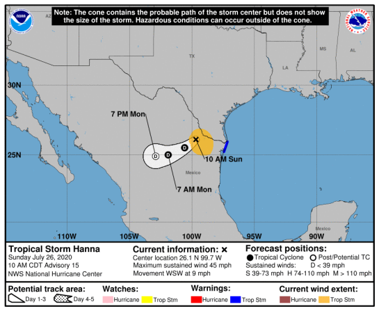
Europe: ESTOFEX Storm Forecast: Level 2 for NW France, S Germany, Czechia, N Switzerland and N Austria mainly for severe convective wind gusts and tornadoes. Valid until 281013 06:00 UTC – 271013 1000z

Storm Forecast


Storm Forecast
Valid: Sun 27 Oct 2013 06:00 to Mon 28 Oct 2013 06:00 UTC
Issued: Sun 27 Oct 2013 05:14
Forecaster: VAN DER VELDE

A level 2 was issued for northeastern France, southern Germany, Czechia, northern Switzerland and northern Austria mainly for severe convective wind gusts and tornadoes.

A level 1 was issued for parts of France, Belgium, Netherlands, Germany, Czech Republic, Poland, as well as Ireland, mainly for severe convective wind gusts and tornadoes.

A level 1 was issued for western France and southern UK for severe convective gust and tornado chances after midnight.

SYNOPSIS

A large depression centered west of Scotland has transported a broad plume of relatively warm low level air deep into Europe. A sharp shortwave trough dramatically visible in IPV fields is racing from western France to eastern Poland during the period. Together with a northwesterly jet axis left exit region, it forces rising air with steepening lapse rates between central France and the Netherlands in the morning, which shifts into Germany during the afternoon and Czechia/Poland in the evening. Thedynamic tropopause(PV)/jet axis intersection region moves just north of the Alps. There is a strong wind field with a corridor over southern Germany with >30 m/s winds in the lowest kilometers.
Late in the night, a side disturbance of the main low arrives in the English Channel region with signs of rapid cyclogenesis en-route to Denmark, producing gale conditions on Monday.

DISCUSSION

…Ireland…

In the first 6 hours of the period, convection and conditions of strong low-level winds and shear 15-20 m/s are present. The jetstream passes over the southern half of Ireland. Expect some convective gusts greater than 25 m/s. An isolated tornado cannot be ruled out as well.

…western France, southern UK…

This region will be affected by two disturbances in 24 hours. At 06Z, unstable air under the influence of the shortwave trough is present as well as 25 m/s mean winds in the low levels, and some 20 m/s 0-1 km shear. Mesoscale convective development is not yet expected to begin, but these conditions combined with low LCL heights can lead to tornadoes, aside from severe wind gusts.
After 00/03Z, the cold front of the second low comes in. It seems to become somewhat convectively active, likely as a forced convective line (there is little CAPE and EL at only -15), this time with 30-40 m/s mean winds in the low levels over NW France capable of producing damaging gusts at the ground. The front bends back over the southern UK with less strong wind field but enhanced shear and instability sufficient for a tornado or two. The 00Z GFS run predicts the low to take a much more northerly and faster course with more stable conditions than the 18Z run.

…northeastern France to southwestern Poland…

Synoptic and mesoscale lifting appears to increase in tyhe GFS model over northern France and enhance CAPE to about 200 J/kg. A linear PV intrusion is likely to shape the convection as a line, although WRF models suggest more cellular/short line segment modes instead. Indeed even in the GFS model there is a large region of deep convergence but no sharp line at the surface. The jet exit region affects most directly the zone immediately north of the Alps. In entire southern Germany more than 20 m/s of 0-1 km shear should exist, which aids tornadogenesis (with >250 m²/s² of 0-3 km SREH also predicted) and bow echoes with strong to very strong gusts during convective storms. The 00Z GFS run predicts the same timing as the 18Z run but with the PV intrusion displaced slightly to the north, as well as more positive rather than negative tilt.

UK: Reports of tornado in Cragg Vale, West Yorkshire (Sat AM) – 271013 0010z (GMT/UTC)

People in Cragg Vale have been likening yesterdays severe weather to a ‘mini tornado’.

Felled trees in Cragg Vale as a tornado hit the valley.

(Photo: halifaxcourier) Felled trees in Cragg Vale as a tornado hit the valley.

(G: NB – There is no such thing as a mini tornado, it is either a tornado or not a tornado)

Roads are reportedly still shut this morning (Saturday) following the freak weather – which saw strong winds and floods hit locations across Calderdale.

Cyclists are currently being warned to approach the popular Cragg Vale route with care – after trees fell down and the road was filled with debris.

A clean up of the area is reportedly underway. It’s believed Cragg Vale is closed just above the 5km mark due to a clearing of trees which came down last night (Friday).

The goings on have sparked a web frenzy, with readers venting on twitter and facebook over the weather.

Saturday, 26 October, 2013 at 14:03 (02:03 PM) UTC RSOE

On Twitter: Western MA Wx ‏(@WMassWx): Another tornado strikes the U.K. on the eastern side of a powerful low in the Northern Atlantic. 964mb to be exact

(Image: Western MA Wx ‏(@WMassWx))


Europe: ESTOFEX Storm Forecast: Level 1 for Portugal, W Spain, Bay of Biscay, & SW British Isles mainly for tornadoes and excessive rain valid until to 251013 0600Z.- 241013 1425Z

Storm Forecast


Storm Forecast
Valid: Thu 24 Oct 2013 06:00 to Fri 25 Oct 2013 06:00 UTC
Issued: Wed 23 Oct 2013 22:44
Forecaster: GATZEN

A level 1 was issued for Portugal, western Spain, Bay of Biscay, and south-western British Isles mainly for tornadoes and excessive rain.

SYNOPSIS

South-westerly flow continues across Europe given rather weak geopotential across the Atlantic Ocean. An embedded short-wave trough will move from southern Scandinavia to the Baltic States, affecting Germany and even the Adriatic Sea with its trough axis. Cold air will spread into central Europe in the wake of this trough. From the west, a weak ridge will follow that affects especially France during the daytime. A new Atlantic trough will enter western Europe until the end of the period.

Ahead of the central European short-wave trough, a tongue of moist and locally unstable air spreads into eastern Europe. Low-level moisture will also increase across western Europe. Steep lapse rates are expected from the Mediterranean to the central Balkans. The central European trough will provide DCVA across the Mediterranean and northern/eastern Europe, whereas warm air advection will increase across Iberia and France late in the period.

DISCUSSION

Portugal and western Spain, Bay of Biscay, south-western British Isles

Ahead of the new approaching trough, another tongue of warm subtropical air spreads into western Europe. Low-level moisture will reach more than 10 g/kg. Whereas rather weak lift is expected near the ridge axis from eastern Spain to southern France, a couple of vort-maxima will travel north-east from Portugal across the Bay of Biscay into south-western Ireland and England. Late in the period, a strong 30 m/s mid-level jet streak will spread across the Bay of Biscay.

Given this strong DCVA and WAA over the region, large ageostrophic flow and low-level convergence is expected. Excessive rain seems to be quite likely from Portugal into the British Isles. In the wake of the leading warm front, lapse rates will increase due to lift along the cyclonically-sheared flank of the jet, and CAPE is forecast.

Current thinking is that thunderstorms will first affect Portugal and will spread north-east, reaching south-west England at the end of the period. Storms will be capable of producing excessive rain. Tornadoes will be an additional threat due to the strong low-level vertical wind shear and low LCL heights. A strong tornado is not ruled out. Tornado potential is expected to spread into the central British Isles on Friday (after the forecast period).

North Mediterranean to southern Austria and Slovakia

The central European trough will pass by leaving a cold front that becomes quasi-stationary at the flank of the south-east European ridge. To the south of the front, a warm and well-mixed airmass with steep lapse rates will affect the Balkans. Along the frontal boundary, a tongue of rich low-level moisture will spread into eastern Europe with 0-1 km mixing ratio exceeding 9 g/kg from northern Italy to Hungary and Slovakia. This moisture will partly overlap with the good lapse rates, resulting in CAPE.

Main uncertainty is the low-level buoyancy due to diurnal heating. The highest potential of storms clearly exists across the Mediterranean Sea in the morning hours, and numerous storms are expected to go on from the Ligurian Sea to the northern Adriatic. Due to the slowly eastward movement of the upper trough, storms will gradually spread south-east into the Tyrrhenian Sea and central Adriatic. Some storms may also evolve across northern and central Italy in the noon/afternoon hours, but low-level stable air masses will limit the potential over most places.

The storms that form across southern Europe will be affected by weak shear. Therefore, well organized storms are not forecast. However, an isolated excessive rain event or a waterspout is not ruled out.

Further north-east, storms are expected to develop along the frontal boundary in the noon and afternoon hours. Main limiting factor will be again the weak low-level buoyancy and CIN may be too large for initiation. Storms that my form can become severe given 15 to 20 m/s 0-3 km vertical wind shear. Especially Mesocyclones may produce large hail and severe wind gusts. The potential decreases from Austria to Slovakia, but a few events are expected. Storms will rapidly weaken after sunset.

Related:

Meteoalarm – severe weather warnings for Europe

UK SEVERE WEATHER and FLOOD WARNINGS Updated 24 Oct 20131345z

Europe: ESTOFEX Storm Forecast: Level 1 for parts of France, Benelux, Germany, Italy and Iberia valid until 241013 0600Z. Tornadoes, Heavy rain and hail possible – 231013 1348z

Storm Forecast

Storm Forecast
Valid: Wed 23 Oct 2013 06:00 to Thu 24 Oct 2013 06:00 UTC
Issued: Tue 22 Oct 2013 21:15
Forecaster: PUCIK

A level 1 was issued for Central France, BENELUX and Northwestern Germany mainly for tornadoes and severe wind gusts.

A level 1 was issued for Southern France and Northern Italy mainly for excessive precipitation and tornadoes.

A level 1 was issued for Western Iberia mainly for excessive precipitation.

SYNOPSIS

General macrosynoptic pattern will remain more or less the same as during the previous days – a broad southwesterly flow is forecast over much of Western and Central Europe situated between deep trough over the Atlantic and ridge over Eastern Europe. This trough will translate towards northeast, slightly de-amplifying the ridge but no major reconfiguration is expected. Unseasonably warm airmass has spread all the way up to Southern Scandinavia, while a weak CAA is expected behind the insignificant cold front that will move from France towards Germany. Another significant trough will approach the Iberian penninsula towards the Thursday morning hours.

DISCUSSION

… Central, NE France, BENELUX, NW Germany …

With cooler, moist airmass overspreading the region, low LCLs are forecast. Only moderately steep mid-level lapse rates will very likely limit the instability build-up, so that only few hundreds J/kg of CAPE are expected at best. Strong, unidirectional wind shear is simulated, with much of the shear within the lowest 1 km, yielding LLS values between 10-15 m/s in the region. With the belt of enhanced PV approaching the area, scattered DMC will initiate. In the strong shear regime, low-topped supercells are well possible, capable of severe wind gusts, tornadoes or some mostly sub-severe hail.

… S France, N / NW Italy ….

In the strong southwesterly flow, a belt of steep mid-level lapse rates is forecast to advect over the Mediterranean Sea along with moist low-level airmass. Moist flow experiencing uplift near the coastline or near the Alps will likely initiate widespread DMC – possibly featuring one or more MCS. In case of the training pattern, moist conditions might enhance precipitation efficiency and locally excessive rainfall is expected. Threat will shift from Southern France towards Northern Italy. MCS will likely start building southwards towards the unstable airmass during the Wednesday night hours. Enhanced low level shear near the coastline along with low cloud bases also point at the elevated tornado risk in the region, albeit this threat should be less prominent than the precipitation risk.

… W Iberia …

During the late afternoon / evening hours, tongue of moist and unstable airmass ahead of the trough is expected to initiate widespread DMC near the coastline. With strong low level convergence and enhanced mixing ratios, isolated excessive precipitation event is quite possible. Tornadoes can not be ruled out in this setup with stronger low level shear inland, albeit CAPE here will be likely mostly elevated, thus possibly rendering this shear ineffective.

Related:

Severe Weather Warnings for Europe. Orange Alerts for Switzerland, France, Italy and Netherlands http://www.meteoalarm.eu