
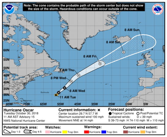
POST-TROPICAL CYCLONE OSCAR
Oscar is a storm equiv to a CAT1 Hurricane on the Saffir Simpson
Hurricane Wind Scale
…..OSCAR BECOMES A HURRICANE-FORCE POST-TROPICAL CYCLONE…
…HIGH SURF TO SUBSIDE ON BERMUDA TONIGHT…….Hurricane-force winds extend outward up to 80 miles (130 km) from the center and tropical-storm-force winds extend outward up to 320
miles (520 km) – NHC FL
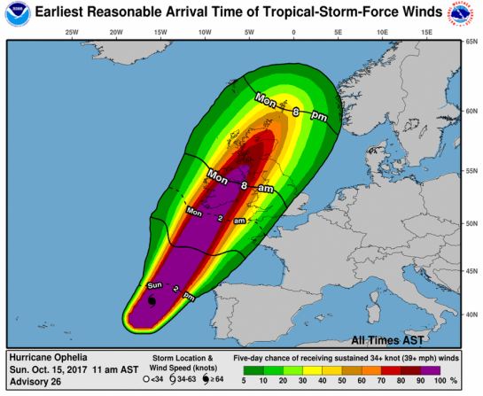
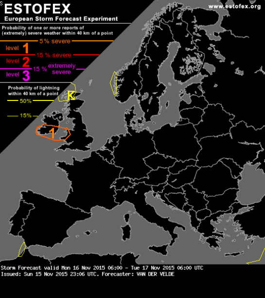
#FaeroeIslands #Iceland #Scotland #Ireland #NorthernIreland be aware!
NATIONAL HURRICANE CENTER FL

ZCZC MIATCPAT1 ALL
TTAA00 KNHC DDHHMM
BULLETIN
Post-Tropical Cyclone Oscar Advisory Number 20
NWS National Hurricane Center Miami FL AL162018
500 PM AST Wed Oct 31 2018
…OSCAR BECOMES A HURRICANE-FORCE POST-TROPICAL CYCLONE…
…HIGH SURF TO SUBSIDE ON BERMUDA TONIGHT…
SUMMARY OF 500 PM AST…2100 UTC…INFORMATION
———————————————-
LOCATION…39.3N 49.6W
ABOUT 540 MI…870 KM SSE OF CAPE RACE NEWFOUNDLAND
ABOUT 975 MI…1570 KM NE OF BERMUDA
MAXIMUM SUSTAINED WINDS…75 MPH…120 KM/H
PRESENT MOVEMENT…NNE OR 30 DEGREES AT 35 MPH…56 KM/H
MINIMUM CENTRAL PRESSURE…976 MB…28.82 INCHES
WATCHES AND WARNINGS
——————–
There are no coastal watches or warnings in effect.
DISCUSSION AND OUTLOOK
———————-
At 500 PM AST (2100 UTC), the center of Post-Tropical Cyclone Oscar
was located near latitude 39.3 North, longitude 49.6 West. The
post-tropical cyclone is moving toward the north-northeast near
35 mph (56 km/h), and a motion toward the northeast with some
decrease in forward speed is expected during the next two to three
days.
Maximum sustained winds are near 75 mph (120 km/h) with higher
gusts. Although gradual weakening is forecast during the next
several days, Oscar is expected to remain a powerful post-tropical
cyclone over the north-central and northeastern Atlantic Ocean into
the weekend.
Hurricane-force winds extend outward up to 80 miles (130 km) from
the center and tropical-storm-force winds extend outward up to 320
miles (520 km).
The estimated minimum central pressure is 976 mb (28.82 inches).
HAZARDS AFFECTING LAND
———————-
SURF: Swells generated by Oscar that are affecting Bermuda will
subside tonight. Please consult products from your local weather
office.
NEXT ADVISORY
————-
This is the last public advisory issued by the National Hurricane
Center on Oscar. Additional information on this system can be found
in High Seas Forecasts issued by the National Weather Service, under
AWIPS header NFDHSFAT1, WMO header FZNT01 KWBC, and available on the
Web at https://ocean.weather.gov/shtml/NFDHSFAT1.shtml.
$$
Forecaster Beven
NNNN
 Canadian Hurricane Centre
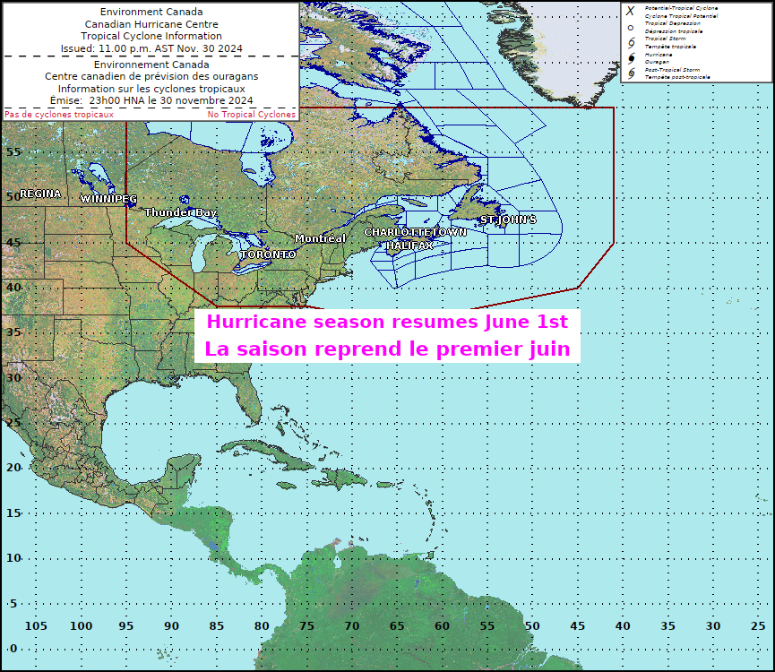
No statements currently issued.

6 pm Wed, Oct 31, 2018 (2100 UTC Wed, Oct 31, 2018)

| Current Position: | 39.3N 49.6W approx. 849 nm NE of Bermuda |
| Recent Movement: | NNE or 30 degrees at 30 kt |
| Central Pressure: | 976 mb / 28.82 in |
| Max Winds: | 65kt gusts 80kt |
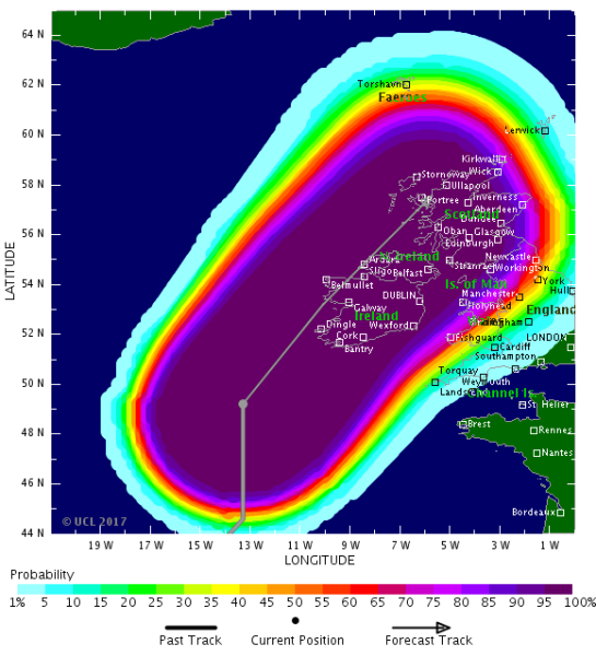
Tropical Storm Risk (TSR)
N Atlantic: Storm Alert issued at 31 Oct, 2018 15:00 GMT
Hurricane OSCAR is currently located near 36.6 N 51.6 W with maximum 1-min sustained winds of 65 kts (75 mph). OSCAR is a category 1 storm on the Saffir Simpson Hurricane Wind Scale. OSCAR is forecast to affect land to the following likelihood(s) at the given lead time(s):
Yellow Alert Country(s) or Province(s)
the Faeroe Islands
probability for TS is 95% in about 93 hours
Iceland
probability for TS is 90% in about 93 hours
Scotland
probability for TS is 90% in about 93 hours
Ireland
probability for TS is 75% in about 93 hours
Northern Ireland
probability for TS is 65% in about 93 hours
Yellow Alert City(s) and Town(s)
Torshavn (62.0 N, 6.8 W)
probability for TS is 95% in about 93 hours
Stornoway (58.3 N, 6.3 W)
probability for TS is 90% in about 93 hours
Ullapool (58.0 N, 5.2 W)
probability for TS is 85% in about 93 hours
Portree (57.5 N, 6.2 W)
probability for TS is 85% in about 93 hours
Lerwick (60.2 N, 1.2 W)
probability for TS is 80% in about 93 hours
Kirkwall (59.0 N, 3.0 W)
probability for TS is 80% in about 93 hours
Wick (58.5 N, 3.1 W)
probability for TS is 80% in about 93 hours
Belmullet (54.2 N, 10.0 W)
probability for TS is 80% in about 93 hours
Inverness (57.3 N, 4.3 W)
probability for TS is 75% in about 93 hours
Oban (56.3 N, 5.5 W)
probability for TS is 75% in about 93 hours
Ardara (54.8 N, 8.4 W)
probability for TS is 75% in about 93 hours
Reykjavik (64.1 N, 21.9 W)
probability for TS is 70% in about 93 hours
Sligo (54.3 N, 8.4 W)
probability for TS is 70% in about 93 hours
Aberdeen (57.2 N, 2.1 W)
probability for TS is 65% in about 93 hours
Dundee (56.5 N, 3.0 W)
probability for TS is 60% in about 93 hours
Glasgow (55.9 N, 4.3 W)
probability for TS is 60% in about 93 hours
Stranraer (55.0 N, 5.0 W)
probability for TS is 55% in about 93 hours
Belfast (54.6 N, 5.9 W)
probability for TS is 55% in about 93 hours
Galway (53.3 N, 9.1 W)
probability for TS is 55% in about 93 hours
Green Alert Country(s) or Province(s)
Jan Mayen
probability for TS is 50% in about 93 hours
England
probability for TS is 35% in about 93 hours
the Isle of Man
probability for TS is 35% in about 93 hours
Green Alert City(s) and Town(s)
Edinburgh (55.8 N, 3.1 W)
probability for TS is 50% in about 93 hours
Workington (54.6 N, 3.4 W)
probability for TS is 35% in about 93 hours
Dublin (53.3 N, 6.3 W)
probability for TS is 35% in about 93 hours
Note that
Yellow Alert (Elevated) is CAT 1 or above to between 10% and 30% probability, or TS to above 50% probability.
Green Alert (Low) is TS to between 31% and 50% probability.
CAT 1 means Hurricane strength winds of at least 74 mph, 119 km/h or 64 knots 1-min sustained.
TS means Tropical Storm strength winds of at least 39 mph, 63 km/h or 34 knots 1-min sustained.
For graphical forecast information and further details please visit http://www.tropicalstormrisk.com/


Current probability of tropical storm winds


Probability of tropical storm winds to 69 hours lead

Probability of tropical storm winds to 93 hours lead

MARITIME/SHIPPING
WTNT21 KNHC 312033
TCMAT1
POST-TROPICAL CYCLONE OSCAR FORECAST/ADVISORY NUMBER 20
NWS NATIONAL HURRICANE CENTER MIAMI FL AL162018
2100 UTC WED OCT 31 2018
THERE ARE NO COASTAL WATCHES OR WARNINGS IN EFFECT.
POST-TROPICAL CYCLONE CENTER LOCATED NEAR 39.3N 49.6W AT 31/2100Z
POSITION ACCURATE WITHIN 20 NM
PRESENT MOVEMENT TOWARD THE NORTH-NORTHEAST OR 30 DEGREES AT 30 KT
ESTIMATED MINIMUM CENTRAL PRESSURE 976 MB
MAX SUSTAINED WINDS 65 KT WITH GUSTS TO 80 KT.
64 KT……. 0NE 70SE 70SW 0NW.
50 KT……. 70NE 100SE 100SW 100NW.
34 KT…….230NE 240SE 240SW 280NW.
12 FT SEAS..330NE 420SE 330SW 360NW.
WINDS AND SEAS VARY GREATLY IN EACH QUADRANT. RADII IN NAUTICAL
MILES ARE THE LARGEST RADII EXPECTED ANYWHERE IN THAT QUADRANT.
REPEAT…CENTER LOCATED NEAR 39.3N 49.6W AT 31/2100Z
AT 31/1800Z CENTER WAS LOCATED NEAR 38.0N 50.5W
FORECAST VALID 01/0600Z 42.6N 46.6W…POST-TROP/EXTRATROP
MAX WIND 65 KT…GUSTS 80 KT.
64 KT… 30NE 60SE 60SW 30NW.
50 KT…100NE 150SE 100SW 90NW.
34 KT…300NE 330SE 240SW 240NW.
FORECAST VALID 01/1800Z 46.8N 41.4W…POST-TROP/EXTRATROP
MAX WIND 65 KT…GUSTS 80 KT.
64 KT… 0NE 30SE 30SW 0NW.
50 KT… 90NE 110SE 120SW 90NW.
34 KT…330NE 360SE 390SW 270NW.
FORECAST VALID 02/0600Z 50.7N 35.1W…POST-TROP/EXTRATROP
MAX WIND 60 KT…GUSTS 75 KT.
50 KT… 40NE 100SE 120SW 90NW.
34 KT…300NE 420SE 390SW 300NW.
FORECAST VALID 02/1800Z 54.2N 28.4W…POST-TROP/EXTRATROP
MAX WIND 60 KT…GUSTS 75 KT.
50 KT… 0NE 120SE 150SW 60NW.
34 KT…360NE 450SE 420SW 300NW.
FORECAST VALID 03/1800Z 59.5N 15.0W…POST-TROP/EXTRATROP
MAX WIND 55 KT…GUSTS 65 KT.
50 KT… 0NE 180SE 120SW 0NW.
34 KT…360NE 480SE 540SW 450NW.
EXTENDED OUTLOOK. NOTE…ERRORS FOR TRACK HAVE AVERAGED NEAR 150 NM
ON DAY 4 AND 175 NM ON DAY 5…AND FOR INTENSITY NEAR 15 KT EACH DAY
OUTLOOK VALID 04/1800Z 67.0N 2.0W…POST-TROP/EXTRATROP
MAX WIND 45 KT…GUSTS 55 KT.
OUTLOOK VALID 05/1800Z…DISSIPATED
REQUEST FOR 3 HOURLY SHIP REPORTS WITHIN 300 MILES OF 39.3N 49.6W
THIS IS THE LAST FORECAST/ADVISORY ISSUED BY THE NATIONAL HURRICANE
CENTER ON OSCAR. ADDITIONAL INFORMATION ON THIS SYSTEM CAN BE FOUND
IN HIGH SEAS FORECASTS ISSUED BY THE NATIONAL WEATHER SERVICE…
UNDER AWIPS HEADER NFDHSFAT1 AND WMO HEADER FZNT01 KWBC.
$$
FORECASTER BEVEN
Canada Hurricane Centre
FZNT01 KWBC 312139
HSFAT1
HIGH SEAS FORECAST FOR METAREA IV
NWS OCEAN PREDICTION CENTER WASHINGTON DC
2230 UTC WED OCT 31 2018
CCODE/1:31:04:01:00/AOE/NWS/CCODE
SUPERSEDED BY NEXT ISSUANCE IN 6 HOURS
SEAS GIVEN AS SIGNIFICANT WAVE HEIGHT…WHICH IS THE AVERAGE
HEIGHT OF THE HIGHEST 1/3 OF THE WAVES. INDIVIDUAL WAVES MAY
BE MORE THAN TWICE THE SIGNIFICANT WAVE HEIGHT.
SEE ANNOUNCEMENT OF PLANNED INMARSAT I-3 TO I-4 MIGRATION
IN 2018 AT OCEAN.WEATHER.GOV/GMDSS_NOTICE.PHP (LOWERCASE).
ONLY YOU KNOW THE WEATHER AT YOUR POSITION. REPORT IT TO THE
NATIONAL WEATHER SERVICE. EMAIL US AT
VOSOPS@NOAA.GOV(LOWERCASE).
FOR INFORMATION ON ATLANTIC ICEBERGS SEE INFORMATION FROM NORTH
AMERICAN ICE SERVICE AT HTTPS://OCEAN.WEATHER.GOV/ATL_TAB.SHTML
PAN PAN
NORTH ATLANTIC NORTH OF 31N TO 67N AND WEST OF 35W
SYNOPSIS VALID 1800 UTC OCT 31.
24 HOUR FORECAST VALID 1800 UTC NOV 01.
48 HOUR FORECAST VALID 1800 UTC NOV 02.
.WARNINGS.
…HURRICANE FORCE WIND WARNING…
.POST-TROPICAL CYCLONE OSCAR NEAR 39.3N 49.6W 976 MB AT 2100 UTC
OCT 31 MOVING NNE OR 030 DEG AT 30 KT. MAXIMUM SUSTAINED WINDS
65 KT GUSTS 80 KT. TROPICAL STORM FORCE WINDS WITHIN 240 NM S
SEMICIRCLE…230 NM NE QUADRANT AND 280 NM NW QUADRANT. SEAS 12
FT OR GREATER WITHIN 330 NM NE AND SW QUADRANTS…360 NM NW
QUADRANT AND 420 NM SE QUADRANT WITH SEAS TO 42 FT. ELSEWHERE
FROM 31N TO 44N BETWEEN 37W AND 64W WINDS 20 TO 33 KT. SEAS 8 TO
12 FT.
.24 HOUR FORECAST POST-TROPICAL CYCLONE OSCAR NEAR 46.8N
41.4W. MAXIMUM SUSTAINED WINDS 65 KT GUSTS 80 KT. TROPICAL STORM
FORCE WINDS WITHIN 330 NM NE QUADRANT…360 NM SE QUADRANT…390
NM SW QUADRANT…AND 270 NM NW QUADRANT. SEAS 12 FT OR GREATER
WITHIN 600 NM NE…660 NM SE…960 NM SW…AND 360 NM NW
QUADRANTS WITH SEAS TO 46 FT. ELSEWHERE FROM 32N TO 54N BETWEEN
35W AND 54W WINDS 20 TO 33 KT. SEAS 8 TO 12 FT.
.48 HOUR FORECAST POST-TROPICAL CYCLONE OSCAR E OF AREA NEAR
54.2N 28.4W. MAXIMUM SUSTAINED WINDS 60 KT GUSTS 75 KT. TROPICAL
STORM FORCE WINDS WITHIN 360 NM NE QUADRANT…450 NM SE
QUADRANT…420 NM SW QUADRANT…AND 300 NM NW QUADRANT. SEAS 12
FT OR GREATER WITHIN 720 NM NE…660 NM SE…1440 NM SW…AND
540 NM NW QUADRANTS WITH SEAS TO 48 FT. ELSEWHERE FROM 41N TO
58N BETWEEN 35W AND 45W WINDS 20 TO 33 KT. SEAS 8 TO 12 FT.
.72 HOUR FORECAST POST-TROPICAL CYCLONE OSCAR NEAR 59.5N
15.0W. MAXIMUM SUSTAINED WINDS 55 KT GUSTS 65 KT.
EXTENDED OUTLOOK…USE FOR GUIDANCE ONLY…ERRORS MAY BE LARGE.
.96 HOUR FORECAST POST-TROPICAL CYCLONE OSCAR NEAR 67.0N
2.0W. MAXIMUM SUSTAINED WINDS 45 KT GUSTS 55 KT.
.120 HOUR FORECAST…DISSIPATED.
…STORM WARNING…
.06 HOUR FORECAST NEW LOW 64N38W 993 MB. WITHIN 120 NM N
SEMICIRCLE WINDS 35 TO 50 KT. SEAS 18 TO 30 FT.
.24 HOUR FORECAST LOW 60N37W 999 MB. N OF 64N AND E OF GREENLAND
WINDS 25 TO 40 KT. SEAS 12 TO 22 FT.
.48 HOUR FORECAST LOW DISSIPATED. WITHIN 60 NM E AND 120 NM SE
OF THE GREENLAND COAST WINDS 25 TO 40 KT. SEAS 10 TO 18 FT.
.SYNOPSIS AND FORECAST.
.COMPLEX LOW WITH MAIN CENTER E OF AREA 50N31W 1001 MB MOVING E
30 KT AND SECOND CENTER 50N45W 1001 MB MOVING E 30 KT. WITHIN
360 NM SW QUADRANT OF MAIN CENTER AND 180 NM NW SEMICIRCLE OF
SECOND CENTER WINDS 20 TO 30 KT. SEAS 8 TO 12 FT.
.24 HOUR FORECAST LOW AND CONDITIONS E OF AREA.
.WITHIN 120 NM W AND SW OF THE GREENLAND COAST S OF 64N WINDS 20
TO 30 KT. SEAS TO 12 FT.
.24 HOUR FORECAST LITTLE CHANGE.
.48 HOUR FORECAST CONDITIONS DIMINISHED.
.24 HOUR FORECAST WITHIN 240 NM NW OF A LINE FROM 40N60W TO
35N75W WINDS TO 25 KT. SEAS TO 8 FT.
.48 HOUR FORECAST NEW LOW 45N45W 1012 MB. WITHIN 300 NM S
QUADRANT WINDS 20 TO 30 KT. SEAS 8 TO 12 FT.
.48 HOUR FORECAST W AND NW OF A LINE FROM 31N70W TO 40N60W WINDS
20 TO 30 KT. SEAS TO 8 TO 12 FT.
.DENSE FOG. VSBY OCCASIONALLY LESS THAN 1 NM FROM 43N TO 47N
BETWEEN 44W AND 50W.
.24 HOUR FORECAST DENSE FOG FROM 46N TO 51N BETWEEN 35W AND 38W.
.48 HOUR FORECAST CONDITIONS E OF AREA.
.DENSE FOG. 48 HOUR FORECAST VSBY OCCASIONALLY LESS THAN 1 NM
FROM 40N TO 44N BETWEEN 66W AND 70W.
.LIGHT FREEZING SPRAY NW OF A LINE FROM 62N62W TO 67N53W.
.24 HOUR FORECAST LITTLE CHANGE.
.48 HOUR FORECAST LITTLE CHANGE.
.HIGH 33N75W 1023 MB MOVING E 15 KT.
.24 HOUR FORECAST HIGH 33N65W 1024 MB.
.48 HOUR FORECAST HIGH 36N54W 1029 MB.
.HIGH 58N62W 1020 MB MOVING E 10 KT.
.24 HOUR FORECAST HIGH 57N54W 1016 MB.
.48 HOUR FORECAST HIGH DISSIPATED.
.FORECASTER ACHORN. OCEAN PREDICTION CENTER.
NATIONAL HURRICANE CENTER MIAMI FL
ATLANTIC FROM 07N TO 31N W OF 35W INCLUDING CARIBBEAN SEA AND
GULF OF MEXICO
SYNOPSIS VALID 1800 UTC WED OCT 31.
24 HOUR FORECAST VALID 1800 UTC THU NOV 01.
48 HOUR FORECAST VALID 1800 UTC FRI NOV 02.
.WARNINGS.
.NONE.
.SYNOPSIS AND FORECAST.
.ATLC OSCAR WELL N OF AREA. COLD FRONT FROM 31N52W TO 22N68W
THEN STATIONARY TO 20N75W. E OF FRONT TO A LINE FROM 31N40W TO
27N47W S TO SW WINDS 20 TO 30 KT. SEAS 8 TO 15 FT. N OF 29N W OF
FRONT TO 60W WINDS 20 TO 30 KT. SEAS 10 TO 16 FT. ELSEWHERE N OF
A LINE FROM 31N38W TO 23N53W TO 28N62W TO 26N72W WINDS 20 KT OR
LESS. SEAS 8 TO 12 FT IN MIXED SWELL.
.24 HOUR FORECAST COLD FRONT FROM 31N43W TO 24N50W TO 22N57W
THEN STATIONARY TO 21N66W. N OF 29N E OF FRONT TO 37W S TO SW
WINDS 20 TO 25 KT. SEAS 8 TO 11 FT. ELSEWHERE N OF A LINE FROM
31N37W TO 27N45W TO 27N57W TO 31N62W WINDS 20 KT OR LESS. SEAS 8
TO 11 FT IN PRIMARILY NW SWELL.
.48 HOUR FORECAST WEAKENING COLD FRONT FROM 31N36W TO 22N48W TO
20N55W THEN DISSIPATING STATIONARY FRONT TO 20N64W. N OF FRONT
WINDS 20 KT OR LESS. SEAS 8 TO 11 FT IN NW SWELL.
.ATLC FROM 16N TO 26N E OF 39W WINDS 20 KT OR LESS. SEAS 8 TO 9
FT IN MIXED NE AND E SWELL.
.24 HOUR FORECAST WINDS 20 KT OR LESS. SEAS LESS THAN 8 FT.
.CARIBBEAN 18 HOUR FORECAST FROM 11N TO 13N BETWEEN 73W AND 77W
NE TO E WINDS 20 TO 25 KT. SEAS TO 8 FT.
.24 HOUR FORECAST WINDS 20 KT OR LESS. SEAS LESS THAN 8 FT.
.36 HOUR FORECAST FROM 11N TO 14N BETWEEN 69W AND 76W E WINDS 20
TO 25 KT. SEAS TO 8 FT.
.48 HOUR FORECAST WINDS 20 KT OR LESS. SEAS LESS THAN 8 FT.
.GULF OF MEXICO 18 HOUR FORECAST N OF 26N W OF 89W S WINDS 20 TO
25 KT. SEAS TO 8 FT.
.24 HOUR FORECAST COLD FRONT FROM 30N93W TO 25N98W. N OF 25N E
OF FRONT TO 85W S TO SW WINDS 20 TO 30 KT. SEAS TO 10 FT. W OF
FRONT NW WINDS 20 TO 25 KT. SEAS TO 8 FT.
.48 HOUR FORECAST COLD FRONT FROM 30N86W TO 22N92W TO 19N96W. W
OF A LINE FROM 23N93W TO 19N96W N TO NW WINDS 20 TO 25 KT. SEAS
TO 8 FT.
.REMAINDER OF AREA WINDS 20 KT OR LESS. SEAS LESS THAN 8 FT.
$$
.FORECASTER LATTO. NATIONAL HURRICANE CENTER.
Latest Watches, Warnings & Advisories
Small Craft Warning
Updated: 4:30 pm Wednesday, October 31, 2018
Issued when winds of mean speed 20 to 33 knots and/or seas of 9 feet or greater are forecast to affect the marine area within the next 36 hours.
The above warning(s) will be updated as conditions warrant.
FQNT21 EGRR 312000
SECURITE
HIGH SEAS BULLETIN FOR METAREA 1
ISSUED AT 2000 UTC ON WEDNESDAY 31 OCTOBER 2018
BY THE MET OFFICE, EXETER, UNITED KINGDOM
FOR THE PERIOD 2000 UTC ON WEDNESDAY 31 OCTOBER UNTIL
2000 UTC ON THURSDAY 01 NOVEMBER 2018
STORM WARNING
AT 311200UTC, NEW LOW MOVING RATHER QUICKLY NORTHEAST
EXPECTED 45 NORTH 45 WEST 968 BY 011200UTC. SOUTHERLY
WINDS ARE EXPECTED TO REACH STORM FORCE 10 IN THE
SOUTHWEST OF THE WEST CENTRAL SECTION AFTER 011600UTC
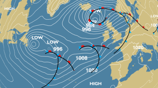
GENERAL SYNOPSIS
AT 311200UTC, NEW LOW MOVING RATHER QUICKLY NORTHEAST
EXPECTED 45 NORTH 45 WEST 968 BY 011200UTC. LOW 64 NORTH
28 WEST 990 EXPECTED 63 NORTH 30 WEST 999 BY SAME TIME.
LOW 51 NORTH 38 WEST 999 EXPECTED 48 NORTH 15 WEST 1008
BY THAT TIME. AT 311200UTC, LOW 59 NORTH 13 WEST 989
EXPECTED 62 NORTH 09 WEST 995 BY 011200UTC. LOW 65 NORTH
00 WEST 986 EXPECTED 68 NORTH 09 WEST 989 BY SAME TIME.
HIGH 66 NORTH 47 WEST 1021 DISSIPATING BY THAT TIME
AREA FORECASTS FOR THE NEXT 24 HOURS
SOLE
NORTHWESTERLY BACKING WESTERLY 4 OR 5, BECOMING VARIABLE
4 LATER. MODERATE OR ROUGH. RAIN OR SHOWERS. MODERATE OR
GOOD
SHANNON ROCKALL
WEST OR NORTHWEST 5 OR 6. ROUGH, OCCASIONALLY MODERATE
LATER. SHOWERS. GOOD
BAILEY
CYCLONIC BECOMING NORTHWEST, 5 TO 7. MODERATE OR ROUGH.
SHOWERS. GOOD
FAEROES SOUTHEAST ICELAND
CYCLONIC 5 TO 7, BECOMING WESTERLY OR NORTHWESTERLY 5 OR
6 LATER. MODERATE OR ROUGH. RAIN OR SHOWERS. MODERATE OR
GOOD
EAST NORTHERN SECTION
CYCLONIC IN FAR NORTHWEST, OTHERWISE NORTHERLY OR
NORTHWESTERLY, 5 TO 7, BACKING SOUTHWESTERLY 4 OR 5 LATER
IN WEST. MODERATE OR ROUGH, OCCASIONALLY VERY ROUGH FOR A
TIME IN FAR NORTHWEST. RAIN OR SHOWERS. MODERATE OR GOOD,
OCCASIONALLY POOR
WEST NORTHERN SECTION
IN NORTH, CYCLONIC 6 TO GALE 8, OCCASIONALLY SEVERE GALE
9 UNTIL LATER IN FAR NORTHWEST. ROUGH OR VERY ROUGH,
OCCASIONALLY HIGH FOR A TIME IN FAR NORTH. RAIN OR
SHOWERS, WITH SNOW IN FAR NORTHWEST. MODERATE OR POOR,
OCCASIONALLY VERY POOR IN FAR NORTHWEST.
IN SOUTH, NORTHWESTERLY BACKING SOUTHWESTERLY 4 OR 5,
BECOMING VARIABLE 3 OR 4 LATER IN FAR SOUTH, THEN
BECOMING EASTERLY OR NORTHEASTERLY 5 OR 6 IN FAR SOUTH.
MODERATE OR ROUGH. SHOWERS, RAIN LATER IN FAR SOUTH.
GOOD, OCCASIONALLY POOR LATER IN FAR SOUTH
EAST CENTRAL SECTION
IN NORTH, NORTHWESTERLY 5 OR 6, BECOMING VARIABLE 3 OR 4,
BECOMING SOUTHEASTERLY 5 TO 7 LATER IN WEST. MODERATE OR
ROUGH. OCCASIONAL RAIN, FOG PATCHES. MODERATE OR GOOD,
OCCASIONALLY VERY POOR.
IN SOUTH, WESTERLY OR SOUTHWESTERLY, BACKING SOUTHERLY
LATER IN WEST, 5 TO 7. MODERATE OR ROUGH. OCCASIONAL
RAIN, FOG PATCHES. MODERATE OR GOOD, OCCASIONALLY VERY
POOR
WEST CENTRAL SECTION
IN NORTH, NORTHERLY OR NORTHEASTERLY 5 OR 6, BECOMING
CYCLONIC 6 TO GALE 8 LATER, OCCASIONALLY SEVERE GALE 9 IN
WEST. MODERATE OR ROUGH, BECOMING ROUGH OR VERY ROUGH
LATER. RAIN OR SHOWERS, FOG PATCHES. MODERATE OR POOR,
OCCASIONALLY VERY POOR.
IN SOUTH, SOUTHWESTERLY 5 TO 7, BACKING SOUTHERLY 6 TO
GALE 8, INCREASING SEVERE GALE 9 OR STORM 10 LATER IN
SOUTHWEST. ROUGH OR VERY ROUGH, BECOMING VERY ROUGH OR
HIGH LATER IN SOUTHWEST. RAIN OR SHOWERS, FOG PATCHES.
MODERATE OR POOR, OCCASIONALLY VERY POOR
DENMARK STRAIT
IN AREA NORTH OF 70 NORTH, NORTHERLY 6 TO GALE 8,
OCCASIONALLY SEVERE GALE 9 IN SOUTH. MODERATE OR ROUGH,
OCCASIONALLY VERY ROUGH IN SOUTH. OCCASIONAL SNOW, FAIR
LATER. MODERATE OCCASIONALLY VERY POOR, BECOMING GOOD
LATER. MODERATE OR SEVERE ICING WITH TEMPERATURES MS05 TO
MS08.
IN AREA SOUTH OF 70 NORTH, EASTERLY OR NORTHEASTERLY 6 TO
GALE 8, OCCASIONALLY SEVERE GALE 9 UNTIL LATER. VERY
ROUGH OR HIGH, BECOMING ROUGH OR VERY ROUGH LATER.
OCCASIONAL RAIN OR SNOW. MODERATE OR POOR, OCCASIONALLY
VERY POOR. MODERATE OR SEVERE ICING IN NORTH WITH
TEMPERATURES MS03 TO MS05
NORTH ICELAND
IN NORTH, NORTHERLY OR NORTHEASTERLY 5 TO 7, INCREASING
GALE 8 OR SEVERE GALE 9 LATER. MODERATE OR ROUGH,
BECOMING ROUGH OR VERY ROUGH LATER. OCCASIONAL RAIN OR
SNOW. MODERATE OR POOR, OCCASIONALLY VERY POOR. SEVERE OR
VERY SEVERE ICING DEVELOPING IN NORTHWEST WITH
TEMPERATURES MS06 TO MS09.
IN SOUTH, NORTHEASTERLY 5 TO 7, BECOMING CYCLONIC 6 TO
GALE 8 LATER, OCCASIONALLY SEVERE GALE 9 IN NORTHWEST.
ROUGH OR VERY ROUGH, OCCASIONALLY MODERATE IN SOUTHEAST.
OCCASIONAL RAIN, WITH SNOW IN NORTHWEST. MODERATE OR
POOR, OCCASIONALLY VERY POOR IN NORTHWEST. LIGHT TO
MODERATE ICING IN NORTHWEST WITH TEMPERATURES AROUND MS02
NORWEGIAN BASIN
SOUTHWESTERLY BACKING SOUTHERLY OR SOUTHEASTERLY, 5 TO 7
INCREASING GALE 8 AT TIMES, DECREASING 3 OR 4 LATER IN
WEST. MODERATE OR ROUGH. RAIN OR SHOWERS. MODERATE OR
GOOD, OCCASIONALLY POOR
OUTLOOK FOR FOLLOWING 24 HOURS:
VIOLENT STORMS EXPECTED IN WEST CENTRAL SECTION. STORMS
EXPECTED IN EAST CENTRAL SECTION AND NORTH ICELAND. GALES
OR SEVERE GALES EXPECTED IN SHANNON, ROCKALL, BAILEY,
EAST NORTHERN SECTION, WEST NORTHERN SECTION, DENMARK
STRAIT AND NORWEGIAN BASIN
UNSCHEDULED STORM WARNINGS ARE BROADCAST VIA SAFETYNET
AND IN
BULLETIN WONT54 EGRR AVAILABLE VIA SOME INTERNET AND
FTPMAIL
OUTLETS=
PassageWeather is a FREE sailing weather website:
http://www.passageweather.com/
=============================================================================================================
Do not use any information on this site for life or death decisions. All information is intended as supplementary to official sources. Kindly refer to your country’s official weather agency/government website for local warnings, advisories and bulletins.


![[Image of 3-day forecast and coastal areas under a warning or a watch]](http://www.nhc.noaa.gov/storm_graphics/AT03/refresh/AL0314W_NL_sm2+gif/174431W_NL_sm.gif)


 INCIDENT AT TOWER BRIDGE


 General Mountain/Moorland Advice from Mountain Rescue England & Wales:

