
HURRICANE DOUGLAS (08E)
………DANGEROUS HURRICANE DOUGLAS CLOSING IN ON THE HAWAIIAN ISLANDS……HURRICANE WARNING ISSUED FOR MAUI COUNTY……NHC FL
DOUGLAS is a category 1 storm on the Saffir Simpson Hurricane Wind Scale (TSR UCL London data)
A Hurricane Warning is in effect for…
* Maui County, including the islands of Maui, Lanai, Molokai and
Kahoolawe
* Oahu
* Kauai County, including the islands of Kauai and Niihau
A Tropical Storm Warning is in effect for…
* Hawaii County
Interests elsewhere in the Papahanaumokuakea Marine National
Monument should monitor the progress of this system.
Douglas will pass near, or over, the islands from
Maui to Kauai today and tonight.
Hawaii /Hawaiian Islands beware
Central Pacific Hurricane Center (FL)


000
WTPA32 PHFO 261439
TCPCP2
BULLETIN
Hurricane Douglas Advisory Number 25
NWS Central Pacific Hurricane Center Honolulu HI EP082020
500 AM HST Sun Jul 26 2020
…DANGEROUS HURRICANE DOUGLAS CLOSING IN ON THE HAWAIIAN ISLANDS…
…HURRICANE WARNING ISSUED FOR MAUI COUNTY…
SUMMARY OF 500 AM HST…1500 UTC…INFORMATION
———————————————-
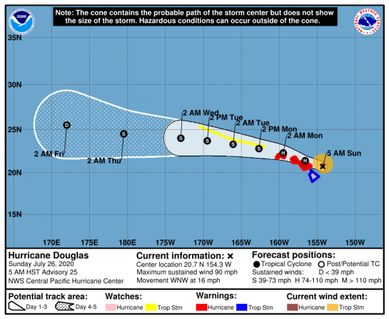
LOCATION…20.7N 154.3W
ABOUT 145 MI…230 KM E OF KAHULUI HAWAII
ABOUT 235 MI…380 KM E OF HONOLULU HAWAII
MAXIMUM SUSTAINED WINDS…90 MPH…150 KM/H
PRESENT MOVEMENT…WNW OR 285 DEGREES AT 16 MPH…26 KM/H
MINIMUM CENTRAL PRESSURE…983 MB…29.03 INCHES
WATCHES AND WARNINGS
——————–
CHANGES WITH THIS ADVISORY…
The Hurricane Watch for Maui County, including the islands of Maui,
Lanai, Molokai and Kahoolawe has been upgraded to a Hurricane
Warning.
The Hurricane Watch has been canceled for Hawaii County.
A Tropical Storm Watch has been issued for portions of the
Papahanaumokuakea Marine National Monument from French Frigate
Shoals to Maro Reef.
SUMMARY OF WATCHES AND WARNINGS IN EFFECT…
A Hurricane Warning is in effect for…
* Maui County, including the islands of Maui, Lanai, Molokai and
Kahoolawe
* Oahu
* Kauai County, including the islands of Kauai and Niihau
A Tropical Storm Warning is in effect for…
* Hawaii County
A Tropical Storm Watch is in effect for…
* Portions of the Papahanaumokuakea Marine National Monument from
Nihoa to French Frigate Shoals to Maro Reef.
A Hurricane Warning means that hurricane conditions are expected
somewhere within the warning area, in this case within the next
24 hours.
A Tropical Storm Warning means that tropical storm conditions are
expected somewhere within the warning area, in this case within the
next 12 hours.
A Tropical Storm Watch means that tropical storm conditions are
possible within the watch area, in this case within the next 36 to
48 hours.
Interests elsewhere in the Papahanaumokuakea Marine National
Monument should monitor the progress of this system.
For storm information specific to your area, please monitor
products issued by the National Weather Service office in
Honolulu Hawaii.
DISCUSSION AND OUTLOOK
———————-
At 500 AM HST (1500 UTC), the center of Hurricane Douglas was
located near latitude 20.7 North, longitude 154.3 West. Douglas is
moving toward the west-northwest near 16 mph (26 km/h) and this
motion is expected to continue over the next couple of days. On the
forecast track, Douglas will pass near, or over, the islands from
Maui to Kauai today and tonight.
Maximum sustained winds are near 90 mph (150 km/h) with higher
gusts. Gradual weakening is forecast during the next 48 hours, but
Douglas is expected to remain a hurricane as it moves through the
islands.
Hurricane-force winds extend outward up to 30 miles (45 km) from the
center and tropical-storm-force winds extend outward up to 105 miles
(165 km).
The estimated minimum central pressure is 983 mb (29.03 inches).
HAZARDS AFFECTING LAND
———————-
WIND: Hurricane conditions are expected in portions of Maui County
today, on Oahu by this afternoon, and on Kauai and Niihau tonight.
Tropical Storm conditions are imminent across the Big Island.
Due to the steep terrain of the islands, hurricane-force wind
gusts are possible even within the tropical storm warning area.
SURF: Large swells generated by Douglas will affect the Hawaiian
Islands into Monday, producing life-threatening and potentially
destructive surf along exposed shores.
STORM SURGE: The combination of higher than predicted water
levels, dangerous storm surge, and large breaking waves will raise
water levels by as much as 3 feet above normal tides near the center
of Douglas.
RAINFALL: Heavy rainfall associated with Douglas is expected to
affect portions of the main Hawaiian Islands from early this
morning into Monday. Total rain accumulations of 5 to 10 inches are
possible from Maui County westward to Kauai County, with the
greatest amounts up to 15 inches in elevated terrain. This rain may
result in life-threatening flash flooding and land slides, as well
as rapid water level rises on small streams. Douglas could produce
an additional 2 to 4 inches of rainfall over the northern half of
the Big Island.
Key messages for Douglas can be found in the Tropical Cyclone
Discussion under AWIPS header HFOTCDCP2 and WMO header WTPA32 PHFO.
NEXT ADVISORY
————-
Next intermediate advisory at 800 AM HST.
Next complete advisory at 1100 AM HST.
$$
Forecaster Birchard


TROPICAL STORM RISK
University College London, UK
NE Pacific: Storm Alert issued at 25 Jul, 2020 9:00 GMT
NE Pacific: Storm Alert issued at 26 Jul, 2020 15:00 GMT
Hurricane DOUGLAS is currently located near 20.7 N 154.3 W with maximum 1-min sustained winds of 80 kts (92 mph). DOUGLAS is a category 1 storm on the Saffir Simpson Hurricane Wind Scale. DOUGLAS is forecast to affect land to the following likelihood(s) at the given lead time(s):
Red Alert City(s) and Town(s)
Honolulu (21.3 N, 157.8 W)
probability for CAT 1 or above is 40% in about 21 hours
probability for TS is 60% within 9 hours
Yellow Alert City(s) and Town(s)
Hilo (19.7 N, 155.1 W)
probability for TS is 60% within 9 hours
Note that
Red Alert (Severe) is CAT 1 or above to between 31% and 100% probability.
Yellow Alert (Elevated) is CAT 1 or above to between 10% and 30% probability, or TS to above 50% probability.
CAT 1 means Hurricane strength winds of at least 74 mph, 119 km/h or 64 knots 1-min sustained.
TS means Tropical Storm strength winds of at least 39 mph, 63 km/h or 34 knots 1-min sustained.
For graphical forecast information and further details please visit http://www.tropicalstormrisk.com/


Current probability of tropical storm wind

Current probability of Cat 1 or above winds

MARITIME/SHIPPING
WTPA22 PHFO 261434
TCMCP2
HURRICANE DOUGLAS FORECAST/ADVISORY NUMBER 25
NWS CENTRAL PACIFIC HURRICANE CENTER HONOLULU HI EP082020
1500 UTC SUN JUL 26 2020
CHANGES IN WATCHES AND WARNINGS WITH THIS ADVISORY…
THE HURRICANE WATCH FOR MAUI COUNTY…INCLUDING THE ISLANDS OF
MAUI…LANAI…MOLOKAI AND KAHOOLAWE HAS BEEN UPGRADED TO A
HURRICANE WARNING.
THE HURRICANE WATCH HAS BEEN CANCELED FOR HAWAII COUNTY.
A TROPICAL STORM WATCH HAS BEEN ISSUED FOR PORTIONS OF THE
PAPAHANAUMOKUAKEA MARINE NATIONAL MONUMENT FROM FRENCH FRIGATE
SHOALS TO MARO REEF.
SUMMARY OF WATCHES AND WARNINGS IN EFFECT…
A HURRICANE WARNING IS IN EFFECT FOR…
* MAUI COUNTY…INCLUDING THE ISLANDS OF MAUI…LANAI…MOLOKAI AND
KAHOOLAWE
* OAHU
* KAUAI COUNTY…INCLUDING THE ISLANDS OF KAUAI AND NIIHAU
A TROPICAL STORM WARNING IS IN EFFECT FOR…
* HAWAII COUNTY
A TROPICAL STORM WATCH IS IN EFFECT FOR…
* PORTIONS OF THE PAPAHANAUMOKUAKEA MARINE NATIONAL MONUMENT FROM
NIHOA TO FRENCH FRIGATE SHOALS TO MARO REEF.
A HURRICANE WARNING MEANS THAT HURRICANE CONDITIONS ARE EXPECTED
SOMEWHERE WITHIN THE WARNING AREA…IN THIS CASE WITHIN THE NEXT
36 HOURS.
A TROPICAL STORM WARNING MEANS THAT TROPICAL STORM CONDITIONS ARE
EXPECTED SOMEWHERE WITHIN THE WARNING AREA…IN THIS CASE WITHIN THE
NEXT 12 HOURS.
A TROPICAL STORM WATCH MEANS THAT TROPICAL STORM CONDITIONS ARE
POSSIBLE WITHIN THE WATCH AREA…IN THIS CASE WITHIN THE NEXT 36 TO
48 HOURS.
INTERESTS ELSEWHERE IN THE PAPAHANAUMOKUAKEA MARINE NATIONAL
MONUMENT SHOULD MONITOR THE PROGRESS OF THIS SYSTEM.
HURRICANE CENTER LOCATED NEAR 20.7N 154.3W AT 26/1500Z
POSITION ACCURATE WITHIN 10 NM
PRESENT MOVEMENT TOWARD THE WEST-NORTHWEST OR 285 DEGREES AT 14 KT
ESTIMATED MINIMUM CENTRAL PRESSURE 983 MB
MAX SUSTAINED WINDS 80 KT WITH GUSTS TO 100 KT.
64 KT……. 25NE 15SE 10SW 25NW.
50 KT……. 40NE 35SE 20SW 40NW.
34 KT……. 90NE 60SE 40SW 90NW.
12 FT SEAS..240NE 150SE 150SW 240NW.
WINDS AND SEAS VARY GREATLY IN EACH QUADRANT. RADII IN NAUTICAL
MILES ARE THE LARGEST RADII EXPECTED ANYWHERE IN THAT QUADRANT.
REPEAT…CENTER LOCATED NEAR 20.7N 154.3W AT 26/1500Z
AT 26/1200Z CENTER WAS LOCATED NEAR 20.5N 153.6W
FORECAST VALID 27/0000Z 21.4N 156.6W
MAX WIND 75 KT…GUSTS 90 KT.
64 KT… 20NE 10SE 10SW 20NW.
50 KT… 40NE 30SE 20SW 40NW.
34 KT… 90NE 60SE 40SW 90NW.
FORECAST VALID 27/1200Z 22.3N 159.5W
MAX WIND 70 KT…GUSTS 85 KT.
64 KT… 10NE 0SE 0SW 10NW.
50 KT… 30NE 20SE 10SW 30NW.
34 KT… 80NE 50SE 30SW 80NW.
FORECAST VALID 28/0000Z 22.8N 162.7W
MAX WIND 60 KT…GUSTS 75 KT.
50 KT… 20NE 10SE 10SW 20NW.
34 KT… 80NE 40SE 30SW 80NW.
FORECAST VALID 28/1200Z 23.3N 166.1W
MAX WIND 55 KT…GUSTS 65 KT.
50 KT… 20NE 10SE 5SW 20NW.
34 KT… 80NE 20SE 10SW 80NW.
FORECAST VALID 29/0000Z 23.7N 169.5W
MAX WIND 50 KT…GUSTS 60 KT.
50 KT… 10NE 0SE 0SW 10NW.
34 KT… 70NE 20SE 10SW 70NW.
FORECAST VALID 29/1200Z 24.0N 173.0W
MAX WIND 45 KT…GUSTS 55 KT.
34 KT… 70NE 20SE 10SW 70NW.
EXTENDED OUTLOOK. NOTE…ERRORS FOR TRACK HAVE AVERAGED NEAR 150 NM
ON DAY 4 AND 200 NM ON DAY 5…AND FOR INTENSITY NEAR 20 KT EACH DAY
OUTLOOK VALID 30/1200Z 24.5N 179.5E
MAX WIND 35 KT…GUSTS 45 KT.
OUTLOOK VALID 31/1200Z 25.5N 172.0E
MAX WIND 30 KT…GUSTS 40 KT.
REQUEST FOR 3 HOURLY SHIP REPORTS WITHIN 300 MILES OF 20.7N 154.3W
INTERMEDIATE PUBLIC ADVISORY…WTNT32 PHFO/HFOTCPCP2…AT 26/1800Z
NEXT ADVISORY AT 26/2100Z
$$
FORECASTER BIRCHARD
=========================================================================

