
Post-Tropical Cyclone LORENZO
…LORENZO BECOMES EXTRATROPICAL BUT STILL EXPECTED TO BRING WINDS
AND RAINFALL TO IRELAND AND PORTIONS OF THE UNITED KINGDOM…
Interests in Ireland should monitor products issued by Met Eireann,
and interests in the United Kingdom should monitor products issued
by the UK Met Office.
IRELAND, NORTHERN IRELAND, UNITED KINGDOM, ISLE OF MAN, FRANCE, CHANNEL ISLANDS, NETHERLANDS, BELGIUM, GERMANY, and LUXEMBOURG BE AWARE!
NATIONAL HURRICANE CENTER FL


000
WTNT33 KNHC 021435
TCPAT3
BULLETIN
Post-Tropical Cyclone Lorenzo Advisory Number 41
NWS National Hurricane Center Miami FL AL132019
1100 AM AST Wed Oct 02 2019
…LORENZO BECOMES EXTRATROPICAL BUT STILL EXPECTED TO BRING WINDS
AND RAINFALL TO IRELAND AND PORTIONS OF THE UNITED KINGDOM…
SUMMARY OF 1100 AM AST…1500 UTC…INFORMATION
———————————————–
LOCATION…44.4N 25.8W
ABOUT 945 MI…1525 KM WSW OF CORK IRELAND
ABOUT 970 MI…1565 KM WSW OF GALWAY IRELAND
MAXIMUM SUSTAINED WINDS…80 MPH…130 KM/H
PRESENT MOVEMENT…NE OR 40 DEGREES AT 43 MPH…69 KM/H
MINIMUM CENTRAL PRESSURE…962 MB…28.41 INCHES
WATCHES AND WARNINGS
——————–
CHANGES WITH THIS ADVISORY:
The Portuguese Institute for the Sea and the Atmosphere has
discontinued all warnings for the Azores.
SUMMARY OF WATCHES AND WARNINGS IN EFFECT:
There are no coastal watches and warnings in effect.
Interests in Ireland should monitor products issued by Met Eireann,
and interests in the United Kingdom should monitor products issued
by the UK Met Office.
DISCUSSION AND OUTLOOK
———————-
At 1100 AM AST (1500 UTC), the center of Post-Tropical Cyclone
Lorenzo was located near latitude 44.4 North, longitude 25.8 West.
The post-tropical cyclone is moving toward the northeast near 43 mph
(69 km/h). A continued fast motion toward the northeast is expected
through Thursday morning. The cyclone is forecast to slow down and
turn eastward and then southeastward Thursday night and Friday. On
the forecast track, the center of post-tropical Lorenzo will move
near western Ireland on Thursday, then pass over Ireland and England
on Thursday night and Friday.
Maximum sustained winds are near 80 mph (130 km/h) with higher
gusts. Only slow weakening is forecast during the next day or so,
and the system is expected to be a strong extratropical cyclone when
it approaches Ireland Thursday afternoon and evening. A faster rate
of weakening is expected when the cyclone moves over Ireland and
England.
Lorenzo is a very large cyclone. Hurricane-force winds extend
outward up to 150 miles (240 km) from the center and tropical-storm-
force winds extend outward up to 390 miles (630 km).
The estimated minimum central pressure is 962 mb (28.41 inches).
HAZARDS AFFECTING LAND
———————-
For hazard information for Lorenzo in Ireland and the United Kingdom
see products issued by Met Eireann and the United Kingdom Met
Office.
SURF: Swells generated by Lorenzo have spread across much of the
North Atlantic basin, and are affecting the east coast of the United
States, Atlantic Canada, the Bahamas, portions of the Greater and
Lesser Antilles, the Azores, and portions of the coast of Europe.
These swells are likely to cause life-threatening surf and rip
current conditions. Please consult products from your local weather
office.
NEXT ADVISORY
————-
This is the last public advisory issued by the National Hurricane
Center on this system. Additional information on this system can be
found in High Seas Forecasts issued by the UK Met Office under WMO
header FQNT21 EGRR and on the web at
https://www.metoffice.gov.uk/weather/specialist-forecasts/coast-and-
sea/high-seas-forecast.
Local forecasts and warnings for Ireland can be found on the website
of Met Eireann, the Irish Meteorological Service, at
http://www.met.ie/.
Local forecasts and warnings for the United Kingdom can be found on
the website of the UK Met Office at http://www.metoffice.gov.uk/.
$$
Forecaster Brown
Ireland
![]()
National Warnings
Status Orange – Wind warning for Galway, Mayo, Clare, Cork, Kerry and Limerick
Southwesterly winds veering westerly will reach mean speeds 65 to 80km/h with gusts generally of 100 to 130km/h, higher in coastal regions.
Storm surges will produce coastal flooding and damage.
Valid: Thursday 03 October 2019 18:00 to Friday 04 October 2019 03:00
Status Yellow – Wind warning for Ireland
Southeasterly winds later veering southwesterly will reach mean speeds 50 to 65km/h with gusts to 100km/h resulting in some disruptive impacts.
Valid: Thursday 03 October 2019 09:00 to Friday 04 October 2019 06:00
Status: Yellow Rainfall warning for Ireland
Status Yellow – Rainfall warning for Ireland
Spells of heavy rain (in excess of 50mm in parts of the west and northwest) will result in some flooding.
Valid: Thursday 03 October 2019 09:00 to Friday 04 October 2019 09:00
Weather Advisory for Ireland
The effects of Storm Lorenzo will begin to be felt across Ireland from Thursday morning, easing Friday morning. The main impacts will include disruptive winds, falling trees and flooding.
In early October, trees are mostly in full leaf with a large surface area, so even moderate strength winds can bring down weakened trees and/or tree limbs. In addition, some trees may be compromised due to saturated soils at the moment, and with more rain forecast with Storm Lorenzo some disruption due to falling trees/branches is likely. Heavy rain, coupled with falling leaves may block drains and gullies, leading to surface flooding.
Coastal:
Storm Lorenzo will produce significant swell, high waves and sizeable storm surges. This will lead to wave overtopping, some coastal flooding and damage, especially along western and southern coasts.
Surface Flooding:
Saturated soils and the expected heavy/thundery rainfall may lead to surface flooding.
River:
River levels are currently elevated across the country and the rainfall may lead to river flooding, especially in parts of the midlands and west. River levels will continue to rise after Storm Lorenzo has passed.
Valid: Thursday 03 October 2019 09:00 to Friday 04 October 2019 09:00
United kingdom
UK Weather Warnings
Issued by the Met Office
-
Yellow warning of wind
Areas affected: Northern Ireland
Starts: 15:00 BST on Thu 3 October
Ends: 22:00 BST on Thu 3 October
A spell of strong south-easterly winds may bring some transport disruption later on Thursday. – Some delays to road, rail, air and ferry transport are likely – Probably some bus and train services affected, with some journeys taking longer – Delays for high-sided vehicles on exposed routes and bridges likely – It’s likely that some coastal routes, sea fronts and coastal communities affected by spray and/or large waves – Some short term loss of power and other services is possible
Issued at: 09:43 BST on Wed 2 October
-
Yellow warning of wind
Areas affected: South West England | Wales
Starts: 04:00 BST on Fri 4 October
Ends: 16:00 BST on Fri 4 October
Strong winds may cause some transport disruption on Friday. – Some delays to road, rail, air and ferry transport are likely – Delays for high-sided vehicles on exposed routes and bridges likely – Some short term loss of power and other services is possible – It’s likely that some coastal routes, sea fronts and coastal communities are affected by spray and/or large waves
Issued at: 09:57 BST on Wed 2 October

Source: http://www.meteociel.fr/observations-meteo/satellite.php
Source: https://ocean.weather.gov/shtml/satellite_imagery.php


TROPICAL STORM RISK
University College London, UK
N Atlantic: Storm Alert issued at 2 Oct, 2019 15:00 GMT (Final Warning)
Hurricane LORENZO is currently located near 44.4 N 25.8 W with maximum 1-min sustained winds of 70 kts (81 mph). LORENZO is a category 1 storm on the Saffir Simpson Hurricane Wind Scale. LORENZO is forecast to affect land to the following likelihood(s) at the given lead time(s):
Red Alert Country(s) or Province(s)
Ireland
probability for CAT 1 or above is 50% in about 33 hours
probability for TS is 100% in about 33 hours
Red Alert City(s) and Town(s)
Belmullet (54.2 N, 10.0 W)
probability for CAT 1 or above is 45% in about 33 hours
probability for TS is 100% in about 33 hours
Galway (53.3 N, 9.1 W)
probability for CAT 1 or above is 35% in about 33 hours
probability for TS is 100% in about 33 hours
Yellow Alert Country(s) or Province(s)
Northern Ireland
probability for CAT 1 or above is 30% in about 45 hours
probability for TS is 100% in about 33 hours
Scotland
probability for TS is 90% in about 33 hours
Wales
probability for TS is 75% in about 33 hours
the Isle of Man
probability for TS is 60% in about 33 hours
England
probability for TS is 55% in about 33 hours
Yellow Alert City(s) and Town(s)
Dingle (52.2 N, 10.2 W)
probability for CAT 1 or above is 30% in about 33 hours
probability for TS is 100% in about 33 hours
Bantry (51.7 N, 9.4 W)
probability for CAT 1 or above is 15% in about 33 hours
probability for TS is 100% in about 33 hours
Ardara (54.8 N, 8.4 W)
probability for CAT 1 or above is 30% in about 33 hours
probability for TS is 100% in about 33 hours
Sligo (54.3 N, 8.4 W)
probability for CAT 1 or above is 30% in about 33 hours
probability for TS is 100% in about 33 hours
Cork (51.9 N, 8.5 W)
probability for CAT 1 or above is 10% in about 33 hours
probability for TS is 100% in about 33 hours
Dublin (53.3 N, 6.3 W)
probability for TS is 95% in about 33 hours
Wexford (52.3 N, 6.5 W)
probability for TS is 95% in about 33 hours
Belfast (54.6 N, 5.9 W)
probability for TS is 90% in about 33 hours
Stranraer (55.0 N, 5.0 W)
probability for TS is 75% in about 45 hours
Oban (56.3 N, 5.5 W)
probability for TS is 70% in about 45 hours
Fishguard (51.9 N, 5.0 W)
probability for TS is 70% in about 33 hours
Portree (57.5 N, 6.2 W)
probability for TS is 65% in about 45 hours
Holyhead (53.3 N, 4.5 W)
probability for TS is 65% in about 33 hours
Lands End (50.1 N, 5.6 W)
probability for TS is 55% in about 33 hours
Green Alert City(s) and Town(s)
Stornoway (58.3 N, 6.3 W)
probability for TS is 50% in about 45 hours
Glasgow (55.9 N, 4.3 W)
probability for TS is 45% in about 45 hours
Cardiff (51.5 N, 3.2 W)
probability for TS is 35% in about 45 hours
Note that
Red Alert (Severe) is CAT 1 or above to between 31% and 100% probability.
Yellow Alert (Elevated) is CAT 1 or above to between 10% and 30% probability, or TS to above 50% probability.
Green Alert (Low) is TS to between 31% and 50% probability.
CAT 1 means Hurricane strength winds of at least 74 mph, 119 km/h or 64 knots 1-min sustained.
TS means Tropical Storm strength winds of at least 39 mph, 63 km/h or 34 knots 1-min sustained.
For graphical forecast information and further details please visit http://www.tropicalstormrisk.com/


Current probability of tropical storm winds

Current probability of Cat 1 or above winds

UK Met Office
We discuss Lorenzo – the process from Hurricane to mid latitude depression, and impacts over the UK. https://t.co/w4BgEfm0Ou
— Met Office (@metoffice) October 1, 2019
MARITIME/SHIPPING
WTNT23 KNHC 021435
TCMAT3
POST-TROPICAL CYCLONE LORENZO FORECAST/ADVISORY NUMBER 41
NWS NATIONAL HURRICANE CENTER MIAMI FL AL132019
1500 UTC WED OCT 02 2019
CHANGES IN WATCHES AND WARNINGS WITH THIS ADVISORY…
THE PORTUGUESE INSTITUTE FOR THE SEA AND THE ATMOSPHERE HAS
DISCONTINUED ALL WARNINGS FOR THE AZORES.
SUMMARY OF WATCHES AND WARNINGS IN EFFECT…
THERE ARE NO COASTAL WATCHES AND WARNINGS IN EFFECT.
INTERESTS IN IRELAND SHOULD MONITOR PRODUCTS ISSUED BY MET
EIREANN…AND INTERESTS IN THE UNITED KINGDOM SHOULD MONITOR
PRODUCTS ISSUED BY THE UK MET OFFICE.
POST-TROPICAL CYCLONE CENTER LOCATED NEAR 44.4N 25.8W AT 02/1500Z
POSITION ACCURATE WITHIN 30 NM
PRESENT MOVEMENT TOWARD THE NORTHEAST OR 40 DEGREES AT 37 KT
ESTIMATED MINIMUM CENTRAL PRESSURE 962 MB
MAX SUSTAINED WINDS 70 KT WITH GUSTS TO 85 KT.
64 KT…….100NE 130SE 120SW 80NW.
50 KT…….200NE 240SE 220SW 150NW.
34 KT…….300NE 340SE 300SW 270NW.
12 FT SEAS..300NE 720SE 840SW 600NW.
WINDS AND SEAS VARY GREATLY IN EACH QUADRANT. RADII IN NAUTICAL
MILES ARE THE LARGEST RADII EXPECTED ANYWHERE IN THAT QUADRANT.
REPEAT…CENTER LOCATED NEAR 44.4N 25.8W AT 02/1500Z
AT 02/1200Z CENTER WAS LOCATED NEAR 43.0N 28.0W
FORECAST VALID 03/0000Z 48.6N 20.8W…POST-TROP/EXTRATROP
MAX WIND 70 KT…GUSTS 85 KT.
64 KT…100NE 130SE 120SW 60NW.
50 KT…180NE 210SE 210SW 120NW.
34 KT…300NE 340SE 300SW 240NW.
FORECAST VALID 03/1200Z 52.8N 14.3W…POST-TROP/EXTRATROP
MAX WIND 65 KT…GUSTS 80 KT.
64 KT…100NE 100SE 120SW 60NW.
50 KT…160NE 160SE 180SW 90NW.
34 KT…300NE 300SE 300SW 240NW.
FORECAST VALID 04/0000Z 54.0N 9.5W…POST-TROP/EXTRATROP
MAX WIND 60 KT…GUSTS 75 KT.
50 KT… 0NE 100SE 120SW 0NW.
34 KT…270NE 300SE 240SW 200NW.
FORECAST VALID 04/1200Z 52.5N 3.5W…POST-TROP/EXTRATROP
MAX WIND 40 KT…GUSTS 50 KT.
34 KT… 0NE 0SE 140SW 0NW.
EXTENDED OUTLOOK. NOTE…ERRORS FOR TRACK HAVE AVERAGED NEAR 150 NM
ON DAY 4 AND 175 NM ON DAY 5…AND FOR INTENSITY NEAR 15 KT EACH DAY
OUTLOOK VALID 05/1200Z…DISSIPATED
REQUEST FOR 3 HOURLY SHIP REPORTS WITHIN 300 MILES OF 44.4N 25.8W
THIS IS THE LAST FORECAST/ADVISORY ISSUED BY THE NATIONAL HURRICANE
CENTER ON THIS SYSTEM. ADDITIONAL INFORMATION ON THIS SYSTEM CAN BE
FOUND IN HIGH SEAS FORECASTS ISSUED BY THE UK MET OFFICE…UNDER WMO
HEADER FQNT21 EGRR.
$$
FORECASTER BROWN
METAREA1 / HIGH_SEAS_WARNING / 022000
WONT54 EGRR 022000
SECURITE
STORM WARNING
AT 021200UTC, HURRICANE LORENZO 43 NORTH 28 WEST BECOMING
EXTRATROPICAL LOW 53 NORTH 13 WEST 968 BY 031200UTC.
WINDS WILL REACH STORM FORCE 10 OR VIOLENT STORM FORCE 11
WITHIN 200 MILES OF THE CENTRE IN THE SOUTHERN SEMICIRCLE
AND WITHIN 150 MILES OF THE CENTRE IN THE NORTHEAST
QUADRANT THROUGHOUT THE FORECAST PERIOD. LOW 57 NORTH 40
WEST 984 EXPECTED 58 NORTH 44 WEST 984 BY SAME TIME.
EASTERLY OR NORTHEASTERLY WINDS ARE EXPECTED TO REACH
STORM FORCE 10 AT TIMES IN THE FAR NORTHWEST OF EAST
NORTHERN SECTION, THE FAR NORTH OF WEST NORTHERN SECTION
AND THE WEST OF DENMARK STRAIT FROM 030300UTC UNTIL
031800UTC
AZORES
bulletins Marine
0000254301
FQAZ67 LPMG 020300
INSTITUTO PORTUGUES DO MAR E DA ATMOSFERA.
WEATHER BULLETIN FOR SHIPPING FOR THE ATLANTIC ZONES
LIMITED BY MERIDIANS 40W-22W AND BY PARALLELS 30N-45N.
I TTT TTT TTT.
HURRICANE WARNING IN ZONES 3(ALTAIR) AND 5(ACORES).
GALE WARNING IN ZONES 30(MILNE) AND 31(MARSALA).
VERY POOR VIS WARNING IN ZONES 3(ALTAIR)E 5(ACORES.
HEAVY WAVES WARNING IN ZONES 3(ALTAIR), 5(ACORES),
7(IRVING), 30(MILNE) AND 31(MARSALA).
HURRICANE WARNING UP TO 20 MILES FROM THE COAST OF
FLORES AND CORVO ISLANDS FROM ACORES
IN ZONE 5(ACORES).
VIOLENT STORM WARNING UP TO 20 MILES FROM
THE COAST OF PICO, FAIAL, S.JORGE, GRACIOSA
AND TERCEIRA ISLANDS FROM ACORES IN ZONE 5(ACORES).
NEAR GALE WARNING UP TO 20 MILES FROM THE COAST
OF S.MIGUEL AND STA. MARIA ISLANDS FROM ACORES
IN ZONE 5(ACORES).
BAD VISIBILITY WARNING UP TO 20 MILES FROM THE COAST
OF FLORES AND CORVO ISLANDS FROM ACORES
IN ZONE 5(ACORES).
HEAVY WAVES WARNING UP TO 20 MILES FROM THE COAST
OF ALL ISLANDS FROM ACORES IN ZONE 5(ACORES).
II – WEATHER SUMMARY AT 020000UTC:
HIGH/ 1023HPA/ 35N15W/ EXP 030000UTC/ 1023HPA/ 35N14W.
HURRICANE LORENZO/ 960HPA/ 38N34W/ MOV NE 20KT/
LITTLE CHANGE.
W-FRONT/ 38N38W/ 42N36W/ 44N32W/ 46N29W/
MOV E/NE 20KT/ MOD TO STGR ACTIVITY.
III – FORECAST VALID TO 030600UTC:
3 – ALTAIR:
CYCLONIC 7 TO 12, BECMG W/NW 5 TO 7
IN W AND 7 TO 10 IN E, DECR TO 4 TO 6 LATER.
POOR TO VERY POOR VIS, BECMG GOOD TO MOD FM
LATE AFTERNOON.
S/SW WAVES 3 TO 5 M, TEMPO INCR TO 9 TO 14 M,
BECMG W WAVES 4 TO 5 M IN W AND 5 TO 7 M IN E LATER.
5 – ACORES:
S QUAD 7 TO 12, BECMG W QUAD 6 TO 8 DURING
AFTERNOON, DECR TO 2 TO 4 LATER.
GOOD TO MOD VIS, BEING POOR TO VERY POOR IN
NW UNTIL MIDDLE AFTERNOON.
SW WAVES 4 TO 8 M, INCR TO 9 TO 14 M, BEING W/SW
WAVES 2 TO 4 M IN E SOON, BECMG W/NW WAVES 5 TO 8 M
FM AFTERNOON, DECR TO 3 TO 5 M LATER.
7 – IRVING:
W/SW 5 TO 7, GRADUALLY DECR TO 2 TO 4
DURING AFTERNOON, BECMG VAR 2 TO 3 FM LATE
AFTERNOON.
GOOD TO MOD VIS.
W/SW WAVES 5 TO 7 M, BEING 2 TO 4 M IN E,
GRADUALLY BECMG W/NW WAVES 3 TO 4 M.
30 – MILNE:
NW 6 TO 8, TEMPO W 4 TO 6, BACK SW AND INCR
TO 6 TO 8 IN N.
GOOD TO MOD VIS.
W QUAD WAVES 4 TO 6 M, BEING 6 TO 9 M IN S,
GRADUALLY DECR TO 3 TO 4 M.
31 – MARSALA:
NW 4 TO 6, BEING 6 TO 8 IN NE, BECMG N/NW 3 TO 4,
BECMG VAR 2 TO 4 LATER.
GOOD TO MOD VIS.
NW WAVES 4 TO 6 M, BEING 6 TO 8 M IN NE,
GRADUALLY DECR TO 3 M.
FORECASTERS: LOURENCO/MEDEIROS/VIEIRA.
SOURCE: INSTITUTO PORTUGUES DO MAR E DA ATMOSFERA –
PORTUGAL.
Source: https://www.ipma.pt/en/maritima/boletins/
Ireland
Status Orange – Gale Warning
Southeast gales or strong gales on Thursday morning on all Irish Coastal Waters and on the Irish Sea, veering southwest and reaching storm force at times in the west.
Issued: Wednesday 02 October 2019 15:00
United Kingdom
Coastal Forecast
A 24 hour weather forecast for 24 UK coastal areas
Tide Tables
Tidal information supplied by the UK Hydrographic Office
Inshore Waters
There are strong wind warnings in 16 areas.
There is a gale warning in 1 area.
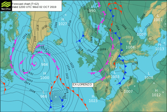
A ridge of high pressure will gradually build from the west tonight. The ridge gradually declining eastwards on Thursday as the remnant low of ex-hurricane Lorenzo moves in to the west of Ireland later in the day. The filling low is then expected to move steadily southeastwards into southwest England during Friday morning.
Shipping Forecast
There are gale warnings in 10 areas.
The general synopsis at midday
Hurricane lorenzo 550 miles west of Fitzroy becoming extratropical, expected Shannon 968 by midday tomorrow
Extended Outlook
The Extended Outlook aims to signpost expected hazards for the Cullercoats, Niton and Portpatrick areas for the three days beyond the 24 hour shipping forecast.
High Seas
There are storm warnings in 8 areas.
The general synopsis at 2 October 19:00 UTC
At 021200UTC, hurricane lorenzo 43 north 28 west becoming extratropical low 53 north 13 west 968 by 031200UTC. Low 57 north 40 west 984 expected 58 north 44 west 984 by same time. Low 46 north 58 west 999 expected 50 north 40 west 977 by that time. at 021200UTC, high 74 north 07 east 1027 expected 70 north 03 east 1027 by 031200UTC. High 41 north 12 west 1023 dissipating
===========================================================================================================
Do not use any information on this site for life or death decisions. All information is intended as supplementary to official sources. Kindly refer to your country’s official weather agency/government website for local warnings, advisories and bulletins.

