
Tropical Depression Harvey
…FLOODING RAINS CONTINUE OVER EXTREME EASTERN TEXAS AND WESTERN
LOUISIANA…
…HEAVY RAINS EXPECTED TO SPREAD NORTHEASTWARD OVER THE MISSISSIPPI
AND TENNESSEE VALLEYS DURING THE NEXT DAY OR TWO…
Catastrophic and life-threatening flooding continues in southeastern
Texas and portions of southwestern Louisiana.
…..catastrophic and life-threatening flooding
will continue in and around Houston, Beaumont/Port Arthur,
and eastward into southwest Louisiana for the rest of the week
(Image: @wunderground)

(Image: @wunderground)
National Hurricane Center (FL)
ZCZC MIATCPAT4 ALL
TTAA00 KNHC DDHHMM
BULLETIN
Tropical Depression Harvey Advisory Number 43
NWS National Hurricane Center Miami FL AL092017
1000 PM CDT Wed Aug 30 2017
…FLOODING RAINS CONTINUE OVER EXTREME EASTERN TEXAS AND WESTERN
LOUISIANA…
…HEAVY RAINS EXPECTED TO SPREAD NORTHEASTWARD OVER THE MISSISSIPPI
AND TENNESSEE VALLEYS DURING THE NEXT DAY OR TWO…
SUMMARY OF 1000 PM CDT…0300 UTC…INFORMATION
———————————————–
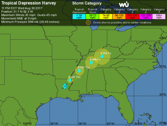
LOCATION…31.7N 92.3W
ABOUT 30 MI…50 KM NNE OF ALEXANDRIA LOUISIANA
ABOUT 100 MI…160 KM SE OF SHREVEPORT LOUISIANA
MAXIMUM SUSTAINED WINDS…35 MPH…55 KM/H
PRESENT MOVEMENT…NNE OR 30 DEGREES AT 9 MPH…15 KM/H
MINIMUM CENTRAL PRESSURE…998 MB…29.47 INCHES
WATCHES AND WARNINGS
——————–
CHANGES WITH THIS ADVISORY:
None
SUMMARY OF WATCHES AND WARNINGS IN EFFECT:
There are no coastal watches or warnings in effect.
Catastrophic and life-threatening flooding continues in southeastern
Texas and portions of southwestern Louisiana. Please see warnings
and other products issued by your local National Weather Service
office for additional information on this life-threatening
situation.
DISCUSSION AND 48-HOUR OUTLOOK
——————————
At 1000 PM CDT (0300 UTC), the center of Tropical Depression Harvey
was located near latitude 31.7 North, longitude 92.3 West. The
depression is moving toward the north-northeast near 9 mph (15 km/h)
and this motion is expected to continue tonight. A turn toward the
northeast is expected Thursday or Thursday night. On the forecast
track, the center of Harvey should move through central Louisiana
tonight, then move through northeastern Louisiana and northwestern
Mississippi Thursday and Thursday night, and over the Tennessee
Valley region on Friday.
Maximum sustained winds are near 35 mph (55 km/h) with higher gusts.
Gradual weakening is expected over the next 48 hours.
The estimated minimum central pressure is 998 mb (29.47 inches).
HAZARDS AFFECTING LAND
———————-
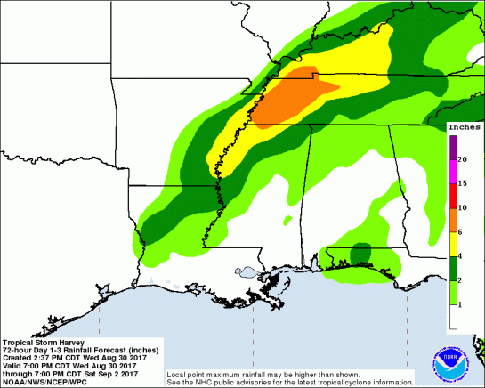
RAINFALL: Harvey is expected to produce additional rainfall
accumulations of 4 to 8 inches from southwestern Louisiana and the
adjacent border of eastern Texas northeastward into western
Tennessee and Kentucky through Friday with isolated amounts up to 12
inches. The threat of heavy rains has ended in the Houston/
Galveston area. However catastrophic and life-threatening flooding
will continue in and around Houston, Beaumont/Port Arthur,
and eastward into southwest Louisiana for the rest of the week. The
expected heavy rains spreading northeastward from Louisiana into
western Kentucky may also lead to flash flooding and increased river
and small stream flooding. DO NOT ATTEMPT TO TRAVEL IN THE AFFECTED
AREA IF YOU ARE IN A SAFE PLACE. DO NOT DRIVE INTO FLOODED
ROADWAYS. Please see warnings and products issued by your local
National Weather Service office for additional information on this
life-threatening situation.
Elsewhere, the outer bands of Harvey are expected to produce
additional rainfall amounts of 3 to 6 inches over portions of the
central and eastern Gulf States and 2 to 4 inches farther north into
parts of the Tennessee Valley, Ohio Valley and southern Mid Atlantic
through Saturday. These rains may lead to flooding concerns across
these areas.
A list of preliminary rainfall observations compiled by the NOAA
Weather Prediction Center can be found at:
http://www.wpc.ncep.noaa.gov/discussions/nfdscc1.html
STORM SURGE: Water levels along the northwestern and northern
Gulf coast should subside very slowly over the next day or two.
TORNADOES: Isolated tornadoes are possible tonight across parts of
Mississippi, southern Alabama, and southwest Georgia. Additional
tornadoes are possible on Thursday afternoon and evening across
northern portions of Mississippi, Alabama, Georgia, and into parts
of Tennessee.
NEXT ADVISORY
————-
This is the last public advisory issued by the National Hurricane
Center on Harvey. Future information on this system can be found in
Public Advisories issued by the Weather Prediction Center beginning
at 4 AM CDT, under AWIPS header TCPAT4, WMO header WTNT34 KWNH, and
on the web at http://www.wpc.ncep.noaa.gov. These advisories will
also continue to be found on the National Hurricane Center website
at hurricanes.gov.
$$
Forecaster Brown
NNNN
=============================================================================
MARITIME/SHIPPING
 METAREA4 / HURRICANE_ADVISORY / 300850
WTNT24 KNHC 310254
TCMAT4
TROPICAL DEPRESSION HARVEY FORECAST/ADVISORY NUMBER 43
NWS NATIONAL HURRICANE CENTER MIAMI FL AL092017
0300 UTC THU AUG 31 2017
CHANGES IN WATCHES AND WARNINGS WITH THIS ADVISORY…
NONE
SUMMARY OF WATCHES AND WARNINGS IN EFFECT…
THERE ARE NO COASTAL WATCHES OR WARNINGS IN EFFECT.
CATASTROPHIC AND LIFE-THREATENING FLOODING CONTINUES IN SOUTHEASTERN
TEXAS AND PORTIONS OF SOUTHWESTERN LOUISIANA. PLEASE SEE WARNINGS
AND OTHER PRODUCTS ISSUED BY YOUR LOCAL NATIONAL WEATHER SERVICE
OFFICE FOR ADDITIONAL INFORMATION ON THIS LIFE-THREATENING
SITUATION.
TROPICAL DEPRESSION CENTER LOCATED NEAR 31.7N 92.3W AT 31/0300Z
POSITION ACCURATE WITHIN 25 NM
PRESENT MOVEMENT TOWARD THE NORTH-NORTHEAST OR 30 DEGREES AT 8 KT
ESTIMATED MINIMUM CENTRAL PRESSURE 998 MB
MAX SUSTAINED WINDS 30 KT WITH GUSTS TO 40 KT.
WINDS AND SEAS VARY GREATLY IN EACH QUADRANT. RADII IN NAUTICAL
MILES ARE THE LARGEST RADII EXPECTED ANYWHERE IN THAT QUADRANT.
REPEAT…CENTER LOCATED NEAR 31.7N 92.3W AT 31/0300Z
AT 31/0000Z CENTER WAS LOCATED NEAR 31.3N 92.6W
FORECAST VALID 31/1200Z 32.8N 91.4W…INLAND
MAX WIND 25 KT…GUSTS 35 KT.
FORECAST VALID 01/0000Z 34.5N 89.7W…INLAND
MAX WIND 25 KT…GUSTS 35 KT.
FORECAST VALID 01/1200Z 35.9N 87.6W…INLAND
MAX WIND 25 KT…GUSTS 35 KT.
FORECAST VALID 02/0000Z 37.0N 85.7W…INLAND
MAX WIND 20 KT…GUSTS 30 KT.
FORECAST VALID 03/0000Z…DISSIPATED
REQUEST FOR 3 HOURLY SHIP REPORTS WITHIN 300 MILES OF 31.7N 92.3W
THIS IS THE LAST FORECAST/ADVISORY ISSUED BY THE NATIONAL HURRICANE
CENTER ON THIS SYSTEM. FUTURE INFORMATION ON THIS SYSTEM CAN BE
FOUND IN PUBLIC ADVISORIES ISSUED BY THE WEATHER PREDICTION CENTER
BEGINNING AT 0900 UTC, UNDER AWIPS HEADER TCPAT4, WMO HEADER
WTNT34 KWNH, AND ON THE WEB AT HTTP://WWW.WPC.NCEP.NOAA.GOV.
$$
FORECASTER BROWN
=============================================================================
000
FZNT24 KNHC 310857
OFFNT4
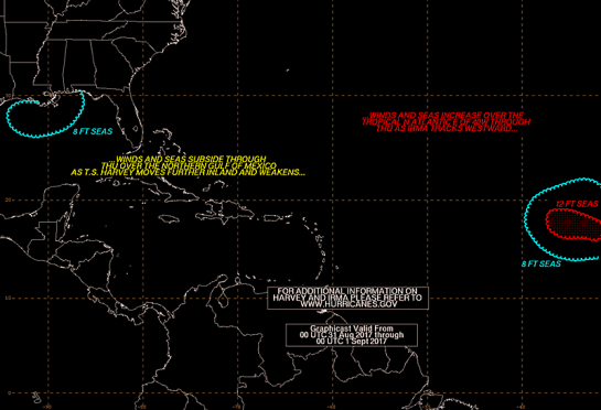
Offshore Waters Forecast for the Gulf of Mexico
NWS National Hurricane Center Miami, FL
457 AM EDT Thu Aug 31 2017
Offshore Waters Forecast for the Gulf of Mexico
Seas given as significant wave height, which is the average
height of the highest 1/3 of the waves. Individual waves may be
more than twice the significant wave height.
GMZ001-312100-
Synopsis for the Gulf of Mexico
457 AM EDT Thu Aug 31 2017
.SYNOPSIS…Tropical Depression Harvey is inland over Louisiana.
As Harvey moves farther inland, a ridge will slowly build back
across the Gulf through the remainder of the week before a trough
develops over the western Gulf this weekend. An area of low pressure
could form along this trough over the southwestern Gulf by the
weekend.
$$
GMZ011-312100-
NW Gulf including Stetson Bank-
457 AM EDT Thu Aug 31 2017
.TODAY…W winds 5 to 10 kt. Seas 2 ft or less.
.TONIGHT…W to NW winds 5 to 10 kt, shifting to SE to S. Seas
2 ft or less.
.FRI…S winds less than 5 kt, shifting to NE to E. Seas 2 ft or
less.
.FRI NIGHT…E winds 5 to 10 kt. Seas 2 ft or less.
.SAT…E winds 5 to 10 kt. Seas 2 ft or less.
.SAT NIGHT…E winds 10 kt. Seas 2 ft or less.
.SUN…E winds 10 kt. Seas 2 ft or less, building to 3 ft in the
afternoon.
.SUN NIGHT…E winds 10 to 15 kt. Seas 3 ft.
.MON…E to SE winds 10 to 15 kt. Seas 3 to 4 ft.
.MON NIGHT…SE winds 10 to 15 kt. Seas 4 to 6 ft.
$$
GMZ013-312100-
N Central Gulf including Flower Garden Banks Marine Sanctuary-
457 AM EDT Thu Aug 31 2017
.TODAY…SW winds 15 to 20 kt. Seas 4 to 6 ft.
.TONIGHT…SW to W winds 10 to 15 kt. Seas 3 to 5 ft.
.FRI…SW winds 5 to 10 kt. Seas 3 ft, subsiding to 2 ft or
less.
.FRI NIGHT…SW winds 5 to 10 kt, shifting to NE to E late. Seas
2 ft or less.
.SAT…E to SE winds 5 to 10 kt. Seas 2 ft or less.
.SAT NIGHT…SE winds 5 to 10 kt. Seas 2 ft or less.
.SUN…E to SE winds 5 to 10 kt. Seas 2 ft or less.
.SUN NIGHT…SE winds 5 to 10 kt. Seas 2 ft or less.
.MON…E to SE winds 10 to 15 kt. Seas 2 ft or less, building to
3 ft in the afternoon.
.MON NIGHT…E to SE winds 10 to 15 kt. Seas 3 to 4 ft.
$$
GMZ015-312100-
NE Gulf N of 25N E of 87W-
457 AM EDT Thu Aug 31 2017
.TODAY…SE to S winds 10 to 15 kt. Seas 4 to 6 ft.
.TONIGHT…SE winds 5 to 10 kt S of 27N, and S to SW 10 to 15 kt
elsewhere. Seas 3 to 5 ft.
.FRI…S to SW winds 5 to 10 kt. Seas 3 to 4 ft.
.FRI NIGHT…W winds 5 to 10 kt, shifting to SE to S late. Seas 3 ft, subsiding to 2 ft or less.
.SAT…SE winds less than 5 kt. Seas 2 ft or less.
.SAT NIGHT…NE winds less than 5 kt. Seas 2 ft or less.
.SUN…NE to E winds 5 to 10 kt. Seas 2 ft or less.
.SUN NIGHT…NE to E winds 5 to 10 kt. Seas 2 ft or less.
.MON…NE to E winds 5 to 10 kt. Seas 2 ft or less.
.MON NIGHT…NE to E winds 10 to 15 kt. Seas 2 ft or less.
$$
GMZ017-312100-
W Central Gulf from 22N to 26N W of 94W-
457 AM EDT Thu Aug 31 2017
.TODAY…SE winds 5 to 10 kt. Seas 2 ft or less.
.TONIGHT…E winds 5 to 10 kt. Seas 2 ft or less.
.FRI…E winds 5 to 10 kt. Seas 2 ft or less. Scattered showers
and isolated thunderstorms.
.FRI NIGHT…E to SE winds 5 to 10 kt. Seas 2 ft or less.
.SAT…E winds 5 to 10 kt. Seas 2 ft or less.
.SAT NIGHT…NE to E winds 5 to 10 kt. Seas 3 ft.
.SUN…NE to E winds 5 to 10 kt. Seas 3 ft.
.SUN NIGHT…E winds 10 to 15 kt. Seas 3 to 5 ft.
.MON…E to SE winds 15 to 20 kt. Seas 4 to 6 ft.
.MON NIGHT…E to SE winds 15 to 20 kt. Seas 4 to 6 ft.
$$
GMZ019-312100-
Central Gulf from 22N to 26N between 87W and 94W-
457 AM EDT Thu Aug 31 2017
.TODAY…SE to S winds 5 to 10 kt. Seas 3 to 4 ft.
.TONIGHT…E winds 10 to 15 kt S of 24N, and E to SE 5 to 10 kt
elsewhere. Seas 3 ft, subsiding to 2 ft or less.
.FRI…SE winds 10 to 15 kt. Seas 2 ft or less, building to
3 ft. Scattered showers and isolated thunderstorms.
.FRI NIGHT…E winds 15 to 20 kt S of 24N, and E 5 to 10 kt
elsewhere. Seas 3 to 4 ft.
.SAT…E to SE winds 10 to 15 kt. Seas 3 to 4 ft.
.SAT NIGHT…E to SE winds 10 to 15 kt. Seas 3 to 4 ft.
.SUN…E to SE winds 10 to 15 kt. Seas 3 to 4 ft.
.SUN NIGHT…E to SE winds 15 to 20 kt. Seas 3 to 5 ft.
.MON…E to SE winds 15 to 20 kt. Seas 4 to 6 ft.
.MON NIGHT…E winds 15 to 20 kt. Seas 4 to 6 ft.
$$
GMZ021-312100-
E Gulf from 22N to 25N E of 87W including Straits of Florida-
457 AM EDT Thu Aug 31 2017
.TODAY…E to SE winds 5 to 10 kt. Seas 3 ft. Scattered showers
and isolated thunderstorms.
.TONIGHT…E to SE winds 5 to 10 kt. Seas 3 ft.
.FRI…SE winds 5 to 10 kt. Seas 3 ft.
.FRI NIGHT…SE winds 5 to 10 kt, shifting to E. Seas 3 ft,
subsiding to 2 ft or less.
.SAT…E to SE winds 5 to 10 kt. Seas 2 ft or less.
.SAT NIGHT…NE to E winds 5 to 10 kt. Seas 2 ft or less.
.SUN…NE to E winds 10 to 15 kt. Seas 2 ft or less.
.SUN NIGHT…NE to E winds 10 to 15 kt. Seas 3 ft.
.MON…E winds 10 to 15 kt. Seas 3 to 4 ft.
.MON NIGHT…NE to E winds 10 to 15 kt. Seas 3 ft.
$$
GMZ023-312100-
SW Gulf S of 22N W of 94W-
457 AM EDT Thu Aug 31 2017
.TODAY…NE to E winds 5 to 10 kt. Seas 3 ft, subsiding to 2 ft
or less.
.TONIGHT…E winds 5 to 10 kt. Seas 2 ft or less.
.FRI…NE winds 5 to 10 kt. Seas 2 ft or less. Scattered showers
and isolated thunderstorms.
.FRI NIGHT…N winds 5 to 10 kt S of 21N W of 95W, and NE to E
10 to 15 kt elsewhere. Seas 2 ft or less. Scattered showers and
isolated thunderstorms.
.SAT…NE winds 10 to 15 kt, shifting to NW 5 to 10 kt in the
afternoon. Seas 2 ft or less.
.SAT NIGHT…N to NE winds 5 to 10 kt. Seas 3 ft.
.SUN…E to SE winds 10 to 15 kt, shifting to W to NW in the
afternoon. Seas 3 to 4 ft.
.SUN NIGHT…N winds 10 to 15 kt. Seas 3 to 4 ft.
.MON…SW to W winds 10 to 15 kt. Seas 3 to 5 ft.
.MON NIGHT…N to NE winds 10 to 15 kt, shifting to E to SE
late. Seas 3 to 5 ft.
$$
GMZ025-312100-
E Bay of Campeche including Campeche Bank-
457 AM EDT Thu Aug 31 2017
.TODAY…E to SE winds 5 to 10 kt. Seas 3 ft.
.TONIGHT…E winds 10 to 15 kt. Seas 3 ft.
.FRI…E to SE winds 10 to 15 kt. Seas 3 ft in the morning,
subsiding to 2 ft or less. Scattered showers and isolated thunderstorms.
.FRI NIGHT…NE to E winds 15 to 20 kt. Seas 2 ft or less,
building to 3 to 4 ft late. Scattered showers and
isolated thunderstorms.
.SAT…SE winds 10 to 15 kt. Seas 3 to 4 ft.
.SAT NIGHT…E winds 10 to 15 kt. Seas 3 ft in the evening,
subsiding to 2 ft or less.
.SUN…SE winds 10 to 15 kt. Seas 3 ft.
.SUN NIGHT…E winds 15 to 20 kt. Seas 3 to 4 ft.
.MON…E to SE winds 15 to 20 kt. Seas 3 to 5 ft.
.MON NIGHT…NE to E winds 10 to 15 kt. Seas 3 to 4 ft.
$$
Forecaster GR
=============================================================================
Do not use any information on this site for life or death decisions. All information is intended as supplementary to official sources. Kindly refer to your country’s official weather agency/government website for local warnings, advisories and bulletins.


#Trump signs #disaster proclamation as #HurricaneHarvey hits #Texas. #SevereWx #News http://news.sky.com/story/donald-trump-signs-disaster-proclamation-as-hurricane-harvey-hits-11005943
LikeLike
Don’t play with the Alligators!!
LikeLike
//platform.twitter.com/widgets.js
LikeLike
//platform.twitter.com/widgets.js
LikeLike