
==UK==
STORM BARNEY
SKYWARN
Severe Weather Alert #54 issued (See below)
Met Office Severe Weather Warnings:
Met Office Weather Warnings for mobile
Highlands & Eilean Siar Yellow Warning
London & South East England Yellow Warning
North West England Yellow Warning
South West England Yellow Warning
Yorkshire & Humber Yellow Warning
Orkney & Shetland Yellow Warning
East of England Yellow Warning
North East England Yellow Warning
(For details follow above links)
20 Flood Warnings in England and Wales – 6 in Scotland
at
22:52 on 16 Nov 2015 GMT
29 Flood Alerts in England and Wales – 5 in Scotland
at
22:52 on 16 Nov 2015 GMT
( Check for interim updates in comments at bottom of page)
Severe Weather Warnings for Europe are now toward the bottom of the page

UK Visible Satellite (meteocentre.com)
UK Infra Red Satellite (meteocentre.com)
Weather Radar Europe (meteox.co.uk)
Channel Islands (Jersey) Weather Radar Latest Animation
Jersey Radar also covers much of South/South West of England & N France
CI weather warnings
![]()
SkyWarn UK’s mission is to forecast, report, and record severe weather.
SKYWARN UK CURRENT ALERT (Link)
Severe Weather Alert #54
SWUK has issued a Severe Weather Alert for strong winds in excess of 70mph
Valid from 1300hrs Tuesday 17th November to 0300hrs Wednesday 18th November.
for
South and South Western England & Wales
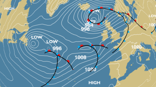
An easterly moving low pressure system (officially named ‘Barney’ by the MetO) will track across southern UK on Tuesday afternoon and evening.
Wind gusts could exceed SWUK criteria of 70mph along exposed coasts on the southern flank of the low.
Wales and the Bristol Channel could see gusts of 80mph
Spotters in the alert area are requested to report any breaches of SWUK criteria in the normal manner.
For details on SkyWarn UK’s alert criteria, click HERE.
 The Tornado & Storm Research Organisation (TORRO)
The latest Severe Weather Reports from TORRO can be found by following this link:
SEVERE WEATHER FORECAST
Report Severe Weather
Latest news reports (see bottom of page)
 Weather
Monday
Tuesday
Wednesday
UK Warnings
Warnings
Monday 16 November Published at 16:54
UK Warnings
Weather Warning
Issued by the Met Office
YELLOW WARNING OF WIND for NORTHWEST SCOTLAND
Issued at 10:35 on Mon 16 Nov
Valid from 11:00 on Mon 16 Nov
Valid until 23:55 on Mon 16 Nov
Southwesterly winds will increase during Monday, when severe gales will affect parts of the northwest mainland of Scotland, the Western Isles and Northern Isles. The strongest winds will initially develop across the Western Isles and northwest coast this afternoon before extending into the Northern Isles during the evening. Winds will quickly ease on Tuesday.
Gusts of wind of 65-75 mph are expected in places, so be aware that there may be some further disruption to travel. Additionally, large waves may cause some overtopping of sea defences.
This an update to the warning issued on Sunday morning.
Further updates will appear here.
YELLOW WARNING OF RAIN for NORTH WALES and NORTH ENGLAND
Issued at 10:23 on Mon 16 Nov
Valid from 10:00 on Tue 17 Nov
Valid until 23:45 on Tue 17 Nov
Further rain is expected on Tuesday as a frontal system runs across the UK from the west. The largest accumulations are expected across the hills of northwest England and northwest Wales though low lying areas will also see a period of heavy rain. On the southern side of this system some very strong winds are expected and a separate warning for winds is likely to be issued.
The public should be aware that, given the already saturated conditions, flooding is possible either from standing water or from rivers already swollen by recent rainfall. This could lead to disruption to travel and perhaps localised flooding to properties.
This is a further update to the warning originally issued on Friday, reducing the northern extent of the warning and moving into minor impacts.
Further updates will appear here.
YELLOW WARNING of WIND for much of WALES and SOUTHERN ENGLAND
Issued at 10:46 on Mon 16 Nov
Valid from 15:00 on Tue 17 Nov
Valid until 23:30 on Tue 17 Nov
West to southwesterly gales and locally severe gales are likely to sweep eastwards across parts of Wales, southern, central and eastern England later on Tuesday. Gusts could reach 60-70 mph inland and possibly 80 mph along exposed coasts, particularly Wales and through the Bristol Channel.
Be aware of the risk of disruption to travel and that gusts of this strength could bring down trees and lead to some damage to weakened structures.
Further updates will appear here.
YELLOW EARLY WARNING OF RAIN for NORTH WALES and NORTH ENGLAND
Issued at 12:17 on Sun 15 Nov
Valid from 16:00 on Wed 18 Nov
Valid until 23:45 on Wed 18 Nov
Another spell of heavy rain, accompanied by gale force winds in places, will cross the country on Wednesday, with largest rainfall over the high ground areas already saturated from recent wet weather. Up to 50 mm is expected in the wettest spots in North Wales and NW England.
The public should be aware of the potential for further impacts such as disruption to travel and local flooding.
Further updates will appear here.
When a warning is in force, full information can be found at Met Office Weather Warnings
Northern Ireland: Addition information available from https://www.facebook.com/northernirelandweather?fref=ts
Early Warnings will be issued more than 24 hours ahead of severe weather.
What is a Sudden Stratospheric Warming (SSW)?
Peter Gibbs explains sudden stratospheric warming and why it is often linked to outbreaks of cold weather: Sudden stratospheric warming
Surface Analyses & Observations UK and Europe
https://embed.windyty.com/?surface,wind,now,53.801,3.076,4,,menu,,
Animated map of global wind conditions
Zoomable version live (real-time) lightning map
BE READY FOR BAD WEATHER and other emergencies – Advice and resources
News at bottom of page
FLOOD WARNINGS & ALERTS
There are NO SEVERE FLOOD WARNING currently in force in England & Wales at
22:52 on 16 Nov 2015 GMT
There are NO SEVERE FLOOD WARNINGS currently in force in Scotland at
22:52 on 16 Nov 2015 GMT
 |
Flood Warning Flooding is expected. Immediate action required |
|---|
There are 20 FLOOD WARNINGS currently in force in England & Wales at
22:52 on 16 Nov 2015 GMT
http://apps.environment-agency.gov.uk/flood/31618.aspx
There are 6 FLOOD WARNINGS currently in force in Scotland at
22:52 on 16 Nov 2015 GMT
 |
Flood AlertFlooding is possible. Be prepared. |
|---|
There are 29 FLOOD ALERTS currently in force in England & Wales at
22:52 on 16 Nov 2015 GMT
There are 5 FLOOD ALERTS currently in force in Scotland at
22:52 on 16 Nov 2015 GMT
About the Environment Agency Flood Warnings
The flood warnings are issued by the Environment Agency and the Scottish Environment Protection Agency and sent to the BBC Weather Centre, we then issue a compendium of warnings based on the latest information available. When severe flood warnings are issued they will also be highlighted on TV broadcasts.
Find out more about Flood Warnings
There are a number of ways you find out whether your area is at risk from flooding. Both the Environment Agency (for England and Wales) and the Scottish Environment Protection Agency update their warnings 24 hours a day via the Floodline number.
Floodline 0845 988 1188
Coastal Forecast
A 24 hour weather forecast for 24 UK coastal areas
Tide Tables
Tidal information supplied by the UK Hydrographic Office
Inshore Waters
There are strong wind warnings in 19 areas.
There is a gale warning in 1 area.
The next few days will be dominated by severeal areas of low pressure tracking across the British Isles bringing strong winds, large waves and changeable weather to all parts.
Shipping Forecast
There are gale warnings in 29 areas.
The general synopsis at midday
Low Bailey 964 expected Norwegian Basin 973 by midday tomorrow. New low expected Shannon 983 by same time.
Extended Outlook
The Extended Outlook aims to signpost expected hazards for the Cullercoats, Niton and Portpatrick areas for the three days beyond the 24 hour shipping forecast.
High Seas
There are storm warnings in 8 areas.
The general synopsis at 16 November 20:00 UTC
At 161200UTC low 60 north 13 west 964 expected 63 north 02 east 973 by 171200UTC. Low 48 north 39 west 987 expected 53 north 12 west 983 by same time. Low 50 north 20 west 998 losing its identity by that time. New low moving slowly east expected 53 north 32 west 988 by 171200UTC
PassageWeather is a FREE sailing weather website: http://www.passageweather.com/maps/britisles/mappage.htm
Avalanche Information for the Scottish Mountains (SAIS)
Avalanche Information Service publish the daily forecasts of the avalanche, snow, and mountain conditions at the 5 most popular areas of Scotland during the season.
Latest Forecasts:
![]()
Mountain Weather Information Service
MWIS currently produce forecasts for 8 different mountain areas of the UK as an aid to mountain safety.
Forecasts are produced manually using information from a range of forecast models and forecasters knowledge of mountain weather. New forecasts, for the next three days are produced by 4:30pm daily, normally earlier in the winter, and amended as necessary.
===============================================
News Reports
Storm Barney to hit UK with winds of up to 80mph

Winds of up to 80mph look set to hit parts of the UK as the second storm to be named by the public – Storm Barney – sweeps in this week.
Yellow “be aware” warnings for wind have been issued for Wales, along with southern, central and eastern England on Tuesday afternoon and evening.
It comes as heavy rain brought flooding to parts of England and Wales.
Rivers burst their banks in Cumbria over the weekend with roads, farmland and train services affected.
In mid and north Wales, train services have been disrupted due to flooding.
Low pressure
The Met Office said gusts could reach 70mph inland and up to 80mph along exposed coastal areas, particularly in Wales and through the Bristol Channel, on Tuesday.
Forecasters said the unsettled weather was the result of a series of low pressure systems moving in from the Atlantic.
North-west Scotland, meanwhile, could see severe gales on Monday, with warnings of gusts of up to 75mph.
The Met Office said in Scotland the strongest winds would initially develop across the Western Isles and north-west coast before extending into the Northern Isles during the evening and easing on Tuesday.
More flooding and disruption could be caused when heavy rain falls on already saturated ground in the next few days, the Met Office also warned.
- Up-to-date information on weather warnings and a live flood warning map can be found on the BBC website
The Environment Agency said the overall flood risk remained low and the number of flood warnings was decreasing – but gale-force winds were expected to produce large waves which could top coastal defences, and river levels will remain high over the next week.
Craig Woolhouse, of the EA, urged people to remain alert to the risk and “stay away from raging rivers”.
“With so much standing water around, we ask people to stay out of flood water and not attempt to walk or drive through it,” he added.
Widespread damage
Barney is the second storm considered strong enough to be given a name under a new “name our storms” campaign between the Met Office and Met Eireann.
Storm Abigail caused widespread damage last week, leaving more than 20,000 homes without power and forcing schools to close in Shetland and the Western Isles.
The Highlands and Islands were worst hit by gusts of 84mph, while the rest of the UK experienced thundery showers, gales and flooding
Forecasters say there is due to be a change in the weather at the end of the week, with colder air spreading from the north and bringing wintry showers to northern parts of the UK, particularly over the hills.
![]()
Monday 16 November Published at 10:00
Monthly Outlook
Summary
Turning colder at times – and not so wet
Wet, windy and unusually mild sums up the first half of November for most parts of the UK, although as often happens with these spells of disturbed south-westerly winds the south east of England has escaped with much less rain than elsewhere. The last week has featured both Abigail and Kate – Abigail being the first winter storm in the new Met Office naming scheme, which brought severe gales to N and NW Scotland. Meanwhile the warmth and moisture which were the remnants of Hurricane Kate, swept across the Atlantic and contributed to the worst of this month’s rainfall over the weekend. Parts of Cumbria saw over 200 mm of rain over that period, and so far this month Capel Curig in Snowdonia has received more than 330 mm of rain.
Monday 16 November—Sunday 22 November
More rain and strong winds – colder by the weekend
For most of the week, the spell of very unsettled weather will continue unabated. Severe gales will affect NW Scotland on Monday while most places have a cooler day of sunshine and showers. Further bursts of rain, heavy in places, will spread across England, Wales and Northern Ireland on Monday night and on Tuesday. There will be gales for a time in the south, while Scotland remains in cooler, showery weather. Yet another low pressure system will sweep in on Wednesday, this one dumping most of its rain over Scotland and Northern Ireland, but also threatening N Wales and NW England again. Thursday and Friday will be brighter but windy with showers, and by Friday much colder air will be moving into northern Scotland with showers there turning to snow. The week ends with this much colder air extending south to all parts on Saturday, with a scattering of wintry showers and some sunshine in many areas, so giving a completely different feel to the weekend just gone.
Monday 23 November—Sunday 29 November
Cold start but will it last long?
The last week of November will begin with cold air over the whole country and with sleet or snow showers in some parts – chiefly over Scotland.There will be sunshine by day and frost is likely overnight. Cloudy, milder weather with some rain is expected to return by Tuesday or Wednesday. Beyond that, there could well be a swing back to brighter, showery weather with northerly winds again. But this return to colder weather is also set to be short-lived as we look to the Atlantic for another change.
Monday 30 November—Sunday 13 December
Typical early winter variability
After the likelihood of a couple of settled days around the turn of the month, a return to unsettled weather is expected in the first week of December, with a mixture of rain and showers. With sometimes large fluctuations in temperature forecast, some snow can be expected over high ground at least – particularly in Scotland. The north will have strong winds at times, with gales likely in the northwest. The south is likely to turn more settled again for a while, allowing overnight frost and fog in any calmer periods. For the fortnight as a whole, temperatures are expected to average out around the normal, but the north may be on the cold side.
Next week
Is there any hint of a prolonged mild or cold spell for December?
Monthly forecasting
The weather beyond about a week ahead stretches even the most experienced weather forecaster. Complex numerical weather forecast models from the Met Office and the European Centre for Medium-Range Weather Forecasts (ECMWF) are run many times for the month (and season) ahead to build up a picture of the likelihood of different weather types affecting the UK.
End
*Europe Severe Weather Warnings*
 White:
Missing, insufficient, outdated or suspicious data.Green:
No particular awareness of the weather is required.Yellow:
The weather is potentially dangerous. The weather phenomena that have been forecast are not unusual, but be attentive if you intend to practice activities exposed to meteorological risks. Keep informed about the expected meteorological conditions and do not take any avoidable risk.Orange:
The weather is dangerous. Unusual meteorological phenomena have been forecast. Damage and casualties are likely to happen. Be very vigilant and keep regularly informed about the detailed expected meteorological conditions. Be aware of the risks that might be unavoidable. Follow any advice given by your authorities.Red:
The weather is very dangerous. Exceptionally intense meteorological phenomena have been forecast. Major damage and accidents are likely, in many cases with threat to life and limb, over a wide area. Keep frequently informed about detailed expected meteorological conditions and risks. Follow orders and any advice given by your authorities under all circumstances, be prepared for extraordinary measures.
European Storm Forecast Experiment
The European Storm Forecast Experiment is an initiative of a team of European meteorologists, and students in meteorology, and serves as a platform for exchange of knowledge about forecasting severe convective storms in Europe and elsewhere.

Storm Forecast
Valid: Tue 17 Nov 2015 06:00 to Wed 18 Nov 2015 06:00 UTC
Issued: Mon 16 Nov 2015 22:35
Forecaster: GROENEMEIJER
A level 2 was issued for the Benelux countries, a large part of Germany, the NW Czech Republic and W Poland mainly for severe wind gusts and to a lesser extent for tornadoes.
A level 1 was issued for and area surrounding the level 1, including S Ireland, the S United Kingdom, larger parts of Poland and the Czech Republic, all of Germany and parts of Denmark, France, Switzerland, and Austria, mainly for severe wind gusts and to a lesser extent for tornadoes.
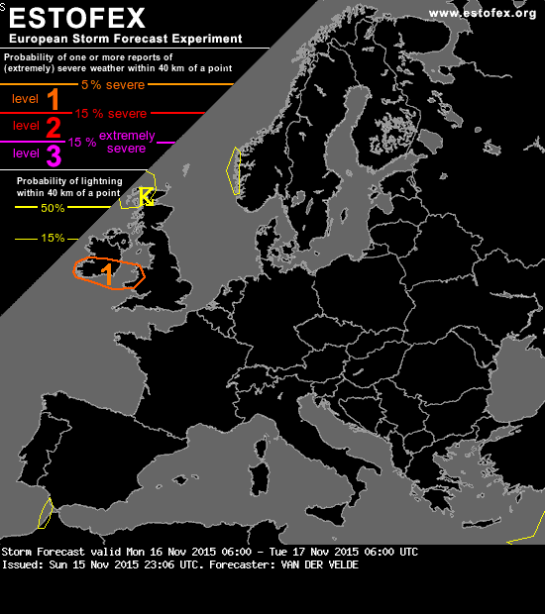
Storm Forecast
Valid: Mon 16 Nov 2015 06:00 to Tue 17 Nov 2015 06:00 UTC
Issued: Sun 15 Nov 2015 23:06
Forecaster: VAN DER VELDE
A level 1 was issued for southern Ireland mainly for chances of a tornado and severe wind gusts.
Satellite: Europe
Do not use any information on this site for life or death decisions. All information is intended as supplementary to official sources. Kindly refer to your country’s official weather agency/government website for local warnings, advisories and bulletins.


Storm Abigail: Schools to be closed and ferries cancelled
“Every school in the Western Isles and Shetland will be closed to pupils on Friday because of the expected arrival of Storm Abigail.
Nearly 60 primary and secondary schools will be affected.
Ferries on the Clyde and Hebrides network have been disrupted already by bad weather with more than half of the services on the 25 routes cancelled.” – BBC News
http://www.bbc.co.uk/news/uk-scotland-highlands-islands-34794583
LikeLike
//platform.twitter.com/widgets.js
LikeLike
//platform.twitter.com/widgets.js
LikeLike
//platform.twitter.com/widgets.js
LikeLike
SEVERE FLOOD WARNINGS (DANGER TO LIFE) mostly in Cumbria:
http://apps.environment-agency.gov.uk/flood/34678.aspx?type=Severity&term=1
LikeLike
AMBER WARNING of RAIN for central & eastern #Scotland. #FloodAware #Wx #News https://t.co/EoPU4qO4A3
— Goaty's News (UK) (@Goatys_News) January 2, 2016
LikeLike
#Scotland #NI #England #Wales #UKstorm #FloodAware #Wx #News/ #UK Severe #Weather Warnings https://t.co/DapgMDpe1K
— Goaty's News (UK) (@Goatys_News) January 2, 2016
LikeLike
BBC WEATHER
Sunday 10 January Published at 20:46
UK Warnings
Weather Warning
Issued by the Met Office
YELLOW WARNING of RAIN for southern England.
Issued at:1723 on Sun 10 Jan 2016
Valid from: 2100 on Sun 10 Jan 2016
Valid to:0900 on Mon 11 Jan 2016
Bands of heavy showers, with localised hail and thunder, will affect parts of southern Britain throughout Sunday evening and overnight, some places affected more than others. The heaviest showers are expected to clear the eastern edge of the warning area, into the North Sea, during Monday morning.
The warning has been updated to extend the area west and slightly north again, which also means the original focus on southeast England looks less certain than it did. Whilst some areas will miss the heaviest rain, please be aware of the potential for surface water flooding causing localised disruption to travel, especially given the saturated ground.
Flood Warning
Issued by the Environment Agency or by SEPA in Scotland and Natural Resources Wales in Wales
FLOOD WARNINGS
Updated 10 January at 20:45
There are flood warnings in force in the following regions:
MIDLANDS (5)
NORTHEAST ENG (10)
NORTHWEST ENG (1)
SOUTHWEST (3)
WALES (1)
SCOTLAND (9)
Further updates will appear here.
About the Met Office Weather Warnings
BBC Weather carries two types of weather warnings issued by the Met Office: Warnings and Early Warnings.
Warnings will be issued when severe weather is expected within the next 24 hours.
Early Warnings will be issued more than 24 hours ahead of severe weather.
There are three categories of event Red, Amber and Yellow – the most severe is Red.
A Warning and an Early Warning of the same colour have the same severity but are forecast to arrive at different times. Thus, the difference between a Red Warning and a Red Early Warning is the lead time of the event.
When a warning is in force, full information can be found at Met Office Weather Warnings
About Flood Warnings
The flood warnings are issued by the Environment Agency, the Scottish Environment Protection Agency and Natural Resources Wales, and sent to the BBC Weather Centre. We then issue a compendium of warnings based on the latest information available. When severe flood warnings are issued they will also be highlighted on TV broadcasts.
Find out more about Flood Warnings
There are a number of ways you find out whether your area is at risk from flooding. The Environment Agency, the Scottish Environment Protection Agency and Natural Resources Wales update their warnings 24 hours a day via the Floodline number.
Floodline – 0345 988 1188
LikeLike
BBC WEATHER
Monday 25 January Published at 12:03
UK Warnings
Weather Warning
Issued by the Met Office
YELLOW WARNING of RAIN for southern, central and western Scotland.
Issued at:1017 on Mon 25 Jan 2016
Valid from:0400 on Tue 26 Jan 2016
Valid to:1800 on Tue 26 Jan 2016
Rain will become persistent and at times heavy early on Tuesday, clearing from the west later in the day. The rain will be accompanied by gales with a risk of severe gales for exposed coasts and hills for a time.
Please be aware of the potential for disruption to travel due to localised flooding.
This is an update to the Alert issued on Sunday, with only minor adjustments to the area and the end time.
YELLOW WARNING of RAIN for Wales. northwest England and southwest England.
Issued at:1049 on Mon 25 Jan 2016
Valid from:0600 on Tue 26 Jan 2016
Valid to:1500 on Wed 27 Jan 2016
Rain will become heavy and persistent at times during Tuesday and into Wednesday. The rain will also be accompanied by south or southwesterly gales and possibly severe gales at times, especially along Irish Sea coasts and over high ground. It looks as if the heaviest rain and strongest winds will occur in two main bouts – one late morning and afternoon on Tuesday and another Tuesday night into Wednesday, before clearing to the southeast on Wednesday afternoon.
Please be aware of the risk of flooding and thus the potential for disruption to travel through this period.
This warning has been updated to adjust the rainfall totals slightly downwards and to remove Lancashire from the warning area.
YELLOW EARLY WARNING of RAIN for Northern Ireland and Scotland.
Issued at:1153 on Mon 25 Jan 2016
Valid from:0300 on Wed 27 Jan 2016
Valid to:1200 on Wed 27 Jan 2016
Another area of heavy rain is expected to move northeast across parts of Northern Ireland and Scotland during Wednesday morning. The rain may also be accompanied by gales or even severe gales briefly later on Wednesday morning, as it clears eastwards. Snow could also affect the Grampians and Northwest Highlands.
Please be aware of the potential for difficult traveling conditions on Wednesday morning, mainly from surface water on roads.
YELLOW EARLY WARNING of RAIN for central and southern England.
Issued at:1115 on Mon 25 Jan 2016
Valid from:0300 on Wed 27 Jan 2016
Valid to:1800 on Wed 27 Jan 2016
An area of rain will move southeastwards across southern England during Wednesday. Some locally heavy rainfall is possible and with this falling on saturated ground some localised flooding is possible. Southwesterly gales are likely along south coasts for a time.
Please be aware of the potential for local disruption to travel from flooding and some difficult driving conditions.
YELLOW EARLY WARNING of RAIN for Wales, northwest England, southern and western Scotland and eastern parts of Northern Ireland.
Issued at:1057 on Mon 25 Jan 2016
Valid from:0005 on Fri 29 Jan 2016
Valid to:2345 on Fri 29 Jan 2016
A further spell of heavy rain is likely to affect many western parts of the UK during Friday, with the largest rainfall totals over west to southwest facing hills. The rain will be accompanied by southwesterly gales.
Please be aware of the risk of further localised flooding and potential impacts on travel.
Flood Warning
Issued by the Environment Agency or by SEPA in Scotland and Natural Resources Wales in Wales
FLOOD WARNINGS
Updated 25 January at 11:45
There are flood warnings in force in the following regions:
SOUTHWEST (3)
SCOTLAND (10)
Further updates will appear here.
About the Met Office Weather Warnings
BBC Weather carries two types of weather warnings issued by the Met Office: Warnings and Early Warnings.
Warnings will be issued when severe weather is expected within the next 24 hours.
Early Warnings will be issued more than 24 hours ahead of severe weather.
There are three categories of event Red, Amber and Yellow – the most severe is Red.
A Warning and an Early Warning of the same colour have the same severity but are forecast to arrive at different times. Thus, the difference between a Red Warning and a Red Early Warning is the lead time of the event.
When a warning is in force, full information can be found at Met Office Weather Warnings
About Flood Warnings
The flood warnings are issued by the Environment Agency, the Scottish Environment Protection Agency and Natural Resources Wales, and sent to the BBC Weather Centre. We then issue a compendium of warnings based on the latest information available. When severe flood warnings are issued they will also be highlighted on TV broadcasts.
Find out more about Flood Warnings
There are a number of ways you find out whether your area is at risk from flooding. The Environment Agency, the Scottish Environment Protection Agency and Natural Resources Wales update their warnings 24 hours a day via the Floodline number.
Floodline – 0345 988 1188
LikeLike